
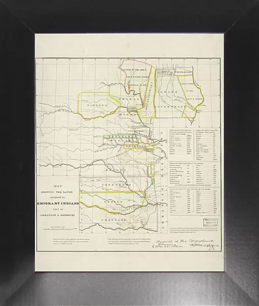
Framed Print : Map showing the lands assigned to emigrant Indians west of Arkansas and Missouri, 1836. Creator: Topographical Bureau


![]()
Framed Photos from Heritage Images
Map showing the lands assigned to emigrant Indians west of Arkansas and Missouri, 1836. Creator: Topographical Bureau
Map showing the lands assigned to emigrant Indians west of Arkansas and Missouri, 1836. Following passage of the Indian Removal Act in 1830, President Andrew Jackson implemented a policy of land exchanges and forced expulsion of the eastern Native Americans to regions west of the Mississippi River. It shows the approximate boundaries of the lands assigned to the relocated tribes in territories west of the Mississippi by 1836. Different shades of color are used to indicate the various tribes. The map also shows the southwestern border of the United States with Mexico, which at that time included the territory that was soon to become the independent Republic of Texas. Forced cession of land by tribes indigenous to the American West, such as the Sioux, is also shown. Approximate geographical boundaries are indicated by rivers, trails, and forts, as territories and states had yet to form in this area. The number of Indians who "emigrated" is listed in the lower right margin, as well as the number of "resident" Indians already living in these regions and the number of Indian tribes remaining east of the Mississippi. Included as well is the total acreage of lands granted by the federal government to the new immigrants according to each tribe
Media ID 35130315
© Heritage Art/Heritage Images
1830s Arkansas Boundary Cartographic Cartography Cherokee Choctaw Creek Delaware Emigrant Expulsion Immigrant Immigration Indians Land Map Making Mapmaking Mississippi Mississippi River Missouri North America North American Omaha Osage Otoe Ottoe Pawnee Pawnees Plains Indian Ponca Removal River Mississippi Sac And Fox Sauk And Fox Shawano Shawnee Sioux Territorial Territory Tribe
12"x10" Modern Frame
10x8 Print in an MDF Wooden Frame with 180 gsm Satin Finish Paper. Glazed using shatter proof thin plexi glass. Frame thickness is 1 inch and depth 0.75 inch. Fluted cardboard backing held with clips. Supplied ready to hang with sawtooth hanger and rubber bumpers. Spot clean with a damp cloth. Packaged foam wrapped in a card.
Contemporary Framed and Mounted Prints - Professionally Made and Ready to Hang
Estimated Image Size (if not cropped) is 25.4cm x 25.4cm (10" x 10")
Estimated Product Size is 25.4cm x 30.5cm (10" x 12")
These are individually made so all sizes are approximate
Artwork printed orientated as per the preview above, with landscape (horizontal) or portrait (vertical) orientation to match the source image.
MADE IN THE USA
Safe Shipping with 30 Day Money Back Guarantee
FREE PERSONALISATION*
We are proud to offer a range of customisation features including Personalised Captions, Color Filters and Picture Zoom Tools
SECURE PAYMENTS
We happily accept a wide range of payment options so you can pay for the things you need in the way that is most convenient for you
* Options may vary by product and licensing agreement. Zoomed Pictures can be adjusted in the Cart.