mail_outline sales@mediastorehouse.com
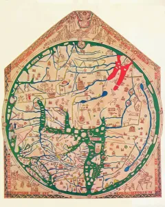
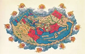
The Hereford Mappa Mundi, (c1285), 1912. Artist: Richard de BelloThe Hereford Mappa Mundi c1285. The Hereford Mappa Mundi is currently on display at Hereford Cathedral in Hereford, England. It is the largest medieval map known to still exist
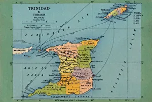
Trinidad & Tobago Map, c1940s. Creator: UnknownTrinidad & Tobago Map, c1940s. From " Trinidad - British West Indies, Land of the Humming Bird". [Tichnor Quality Views, Boston]
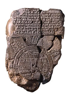
The Babylonian Map of the World, c. 510-c. 500 BC. Artist: Assyrian ArtThe Babylonian Map of the World, c. 510-c. 500 BC. Found in the collection of British Museum
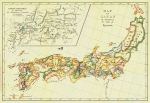
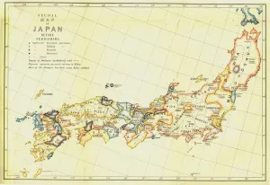
Map of Japan in Provinces in time of Iyeyasu, 1903. Creator: UnknownMap of Japan in Provinces in time of Iyeyasu, 1903. Tokugawa Ieyasu (1543-1616) first shogun of the Tokugawa shogunate which ruled Japan from 1600-1868 and is known as the Edo period
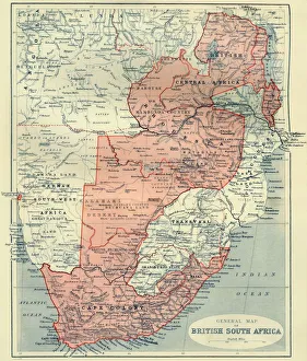
General Map of British South Africa, 1900. Creator: UnknownGeneral Map of British South Africa, 1900. From " South Africa and the Transvaal War, Vol. I", by Louis Creswicke. [T. C. & E. C. Jack, Edinburgh, 1900]
The Selden Map of China. Artist: Chinese MasterThe Selden Map of China. Found in the collection of the Bodleian Library, Oxford
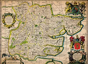
Map of Essex, 1678. Artists: John Ogilby, William MorganMap of Essex, 1678. From Essex, actually surveyed, with the several Roads from London &c. by Francis Lamb. [Philip Lea, Essex, 1678]
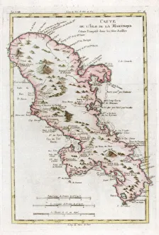
Map of the Caribbean island of Martinique, c1783
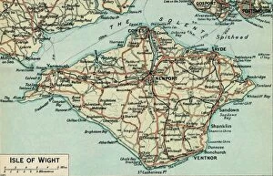
Isle of Wight. c20th Century. Artist: John BartholomewIsle of Wight. c20th Century. [John Bartholomew & Son, Edinburgh]
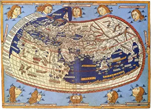
Ptolemys Map of the World cA. D 150. (1912) Artist: Claudius PtolemyPtolemys Map of the World cA.D 150. The Ptolemy world map is a map of the known world to Hellenistic society in the 2nd century AD
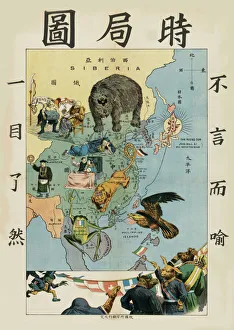
The Situation in the Far East, um 1900-1904. Creator: Tse Tsan-tai (1872-1938)The Situation in the Far East, um 1900-1904. Private Collection
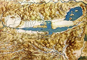
Topographic View of the Countryside around the Plain of Arezzo and the Val di Chiana, Early16th cen.. Found in the collection of the Royal Library, Windsor Castle
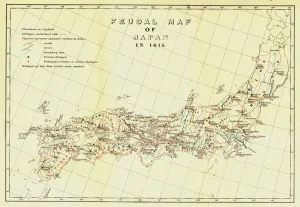
Feudal Map of Japan in 1615, (1903). Creator: UnknownFeudal Map of Japan in 1615, (1903). The feudal period of Japanese history was a time when powerful families (daimyo) and military warlords (shogun) ruled Japan
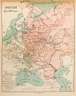
Map of Russia in the 16th and 17th century, 1914. Private Collection
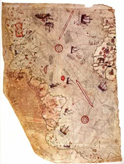
The Piri Reis world map, 1513. Artist: Piri Reis (1470-1553)The Piri Reis world map, 1513. Found in the collection of the Topkapı Palace, Istanbul
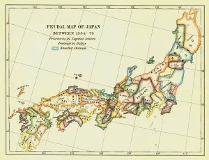
Feudal Map of Japan between 1564 -73, (1903). Creator: UnknownFeudal Map of Japan between 1564 -73, (1903). The feudal period of Japanese history was a time when powerful families (daimyo) and military warlords (shogun) ruled Japan
Feudal Map of Japan before Sekigahara, 1903. Creator: UnknownFeudal Map of Japan before Sekigahara, 1903. The feudal period of Japanese history was a time when powerful families (daimyo) and military warlords (shogun) ruled Japan
Ptolemy World map, 1467. Found in the collection of Biblioteka Narodowa, Warszawa
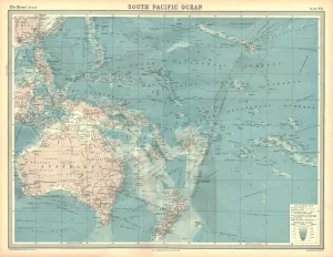
Map of the South Pacific Ocean. Map showing the Philippines, Indonesia, Papua New Guinea, Australia and New Zealand, and Pacific islands. Plate 102 from The Times Atlas
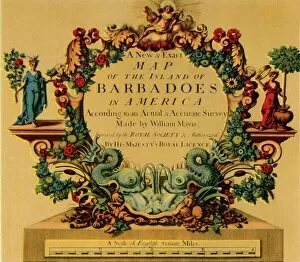
Cartouche on W. Mayos Map of Barbados, 1722, (1944). Creator: William MayoCartouche on W. Mayos Map of Barbados, 1722, (1944). A New & Exact Map of the Island of Barbadoes in America. According to an Actual & Accurate Survey
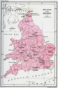
Map of the Wars of the Roses, 15th century (1893). The Wars of the Roses was a civil war fought over the throne of England between adherents of the House of Lancaster and the House of York
The Cantino planisphere, 1502. Artist: Anonymous masterThe Cantino planisphere, 1502. Found in the collection of the Biblioteca Estense Universitaria, Modena
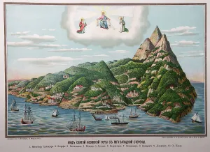
The Holy Mountain Athos, 1885. Artist: Fesenko, Yefim Ivanovich (1850-1926)The Holy Mountain Athos, 1885. Found in the collection of the State History Museum, Moscow
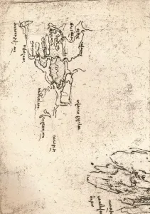
Sketch map of Armenia, c1472-c1519 (1883). Artist: Leonardo da VinciSketch map of Armenia, c1472-c1519 (1883). From the Codex Atlanticus. From The Literary Works of Leonardo Da Vinci, Vol. II by Jean Paul Richter, PH. DR
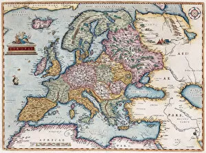
Europae (From: Theatrum Orbis Terrarum), 1579. Artist: Ortelius, Abraham (1527-1598)Europae (From: Theatrum Orbis Terrarum), 1579. From a private collection
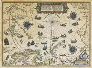
Map of Willem Barentsz Third Voyage, 1598. Artist: Claesz, Cornelis (ca. 1551-1609)Map of Willem Barentsz Third Voyage, 1598. Private Collection
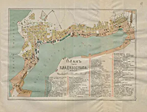
Map of Vladivostok, 1902. Artist: AnonymousMap of Vladivostok, 1902. Private Collection
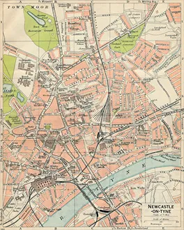
Newcastle-on-Tyne, c20th Century. Artist: John BartholomewNewcastle-on-Tyne, c20th Century. [John Bartholomew & Son, Edinburgh]
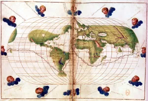
Map of Magellans round the world voyage, 1519-1521. A Portuguese-born navigator sponsored by Spain, Ferdinand Magellan (c1480-1521)
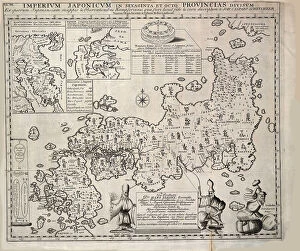
Map of Japan, 1727. Creator: Kaempfer, Engelbert (1651-1716)Map of Japan, 1727. Private Collection
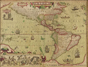
America. From Mercator-Hondius Atlas, c.1620. Creator: Hondius, Jodocus (1563-1612)America. From Mercator-Hondius Atlas, c.1620. Private Collection
The siege of Vienna in 1683, c.1860. Creator: Unknown artistThe siege of Vienna in 1683, c.1860. Private Collection
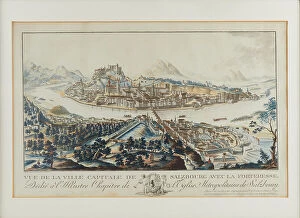
General view over the Salzach to Salzburg with the Hohensalzburg Fortress, c.1790. Creator: Amon, Anton (1761-1798)General view over the Salzach to Salzburg with the Hohensalzburg Fortress, c.1790. Private Collection
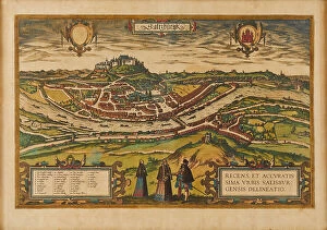
General view of the city of Salzburg. From "Civitates Orbis Terrarum", 1581. Private Collection
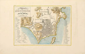
Plan of the city of Rio de Janeiro. From "Voyage pittoresque et historique au Brésil", 1830sPlan of the city of Rio de Janeiro. From "Voyage pittoresque et historique au Bresil", 1830s. Private Collection
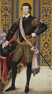
Sir Robert Dudley, Duke of Northumberland, c1600. Creator: Nicholas HilliardSir Robert Dudley, Duke of Northumberland, c1600
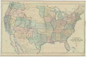
Stanford's railway & county Map of the United States, 1861. Creator: Stanford, Edward (1827-1904)Stanford's railway & county Map of the United States, 1861. Found in the collection of the Bibliotheque Nationale de France
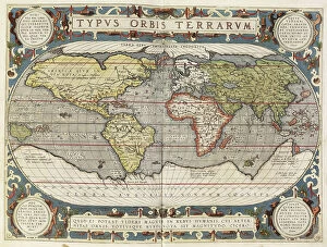
Theatrum Orbis Terrarium, 1592. Creator: UnknownTheatrum Orbis Terrarium, 1592. Called the first modern atlas, adapted from Mercator's world map; large coloured atlas with Ptolemy's Geographia, 1592; continents
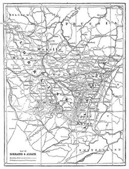
Map of Lorraine and Alsace; Alsace and Lorraine, 1875. Creator: UnknownMap of Lorraine and Alsace; Alsace and Lorraine, 1875. From Illustrated Travels by H.W. Bates. [Cassell, Petter, and Galpin, c1880, London] and Galpin
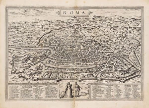
Rome. From Civitates orbis terrarum, 1572. Creator: Braun, Georg (1541-1622)Rome. From Civitates orbis terrarum, 1572. Private Collection
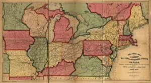
Railroad map of the eastern, western and northern states, and Canada, 1859. Creator: Anonymous masterRailroad map of the eastern, western and northern states, and Canada, 1859. Private Collection
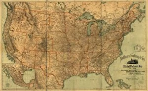
Official railroad map of the United States, Dominion of Canada and Mexico, 1890. Private Collection
Map of the Zurich area, 1566. Creator: Murer, Jos (1530-1580)Map of the Zurich area, 1566. Private Collection
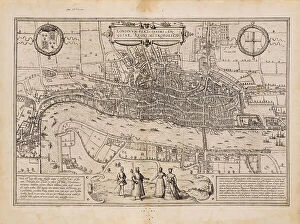
London. From Civitates orbis terrarum, 1572. Creator: Braun, Georg (1541-1622)London. From Civitates orbis terrarum, 1572. Private Collection
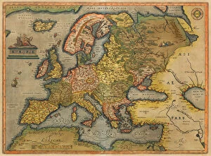
Europae. From Theatrum Orbis Terrarum, 1572. Creator: Ortelius, Abraham (1527-1598)Europae. From Theatrum Orbis Terrarum, 1572. Private Collection
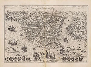
Constantinople. From Civitates orbis terrarum, 1572. Creator: Braun, Georg (1541-1622)Constantinople. From Civitates orbis terrarum, 1572. Private Collection
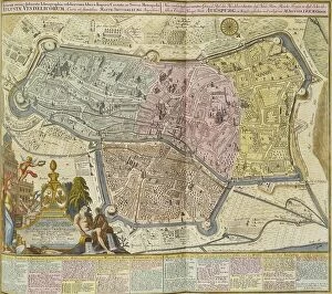
Augsburg, 1742. Creator: Seutter, Matthaeus (1678-1757)Augsburg, 1742. Private Collection
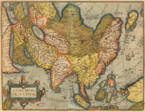
Asiae Nova Descriptio. From Theatrum Orbis Terrarum, 1572. Creator: Ortelius, Abraham (1527-1598)Asiae Nova Descriptio. From Theatrum Orbis Terrarum, 1572. Private Collection