
Map Making Collection

Background imageMap Making Collection: The Hereford Mappa Mundi, (c1285), 1912. Artist: Richard de Bello

The Hereford Mappa Mundi, (c1285), 1912. Artist: Richard de Bello
The Hereford Mappa Mundi c1285. The Hereford Mappa Mundi is currently on display at Hereford Cathedral in Hereford, England. It is the largest medieval map known to still exist

Background imageMap Making Collection: Trinidad & Tobago Map, c1940s. Creator: Unknown

Trinidad & Tobago Map, c1940s. Creator: Unknown
Trinidad & Tobago Map, c1940s. From " Trinidad - British West Indies, Land of the Humming Bird". [Tichnor Quality Views, Boston]

Background imageMap Making Collection: Map of Japan in Provinces in time of Iyeyasu, 1903. Creator: Unknown

Map of Japan in Provinces in time of Iyeyasu, 1903. Creator: Unknown
Map of Japan in Provinces in time of Iyeyasu, 1903. Tokugawa Ieyasu (1543-1616) first shogun of the Tokugawa shogunate which ruled Japan from 1600-1868 and is known as the Edo period

Background imageMap Making Collection: General Map of British South Africa, 1900. Creator: Unknown

General Map of British South Africa, 1900. Creator: Unknown
General Map of British South Africa, 1900. From " South Africa and the Transvaal War, Vol. I", by Louis Creswicke. [T. C. & E. C. Jack, Edinburgh, 1900]

Background imageMap Making Collection: Map of Essex, 1678. Artists: John Ogilby, William Morgan

Map of Essex, 1678. Artists: John Ogilby, William Morgan
Map of Essex, 1678. From Essex, actually surveyed, with the several Roads from London &c. by Francis Lamb. [Philip Lea, Essex, 1678]

Background imageMap Making Collection: Map of the Caribbean island of Martinique, c1783

Map of the Caribbean island of Martinique, c1783

Background imageMap Making Collection: Isle of Wight. c20th Century. Artist: John Bartholomew

Isle of Wight. c20th Century. Artist: John Bartholomew
Isle of Wight. c20th Century. [John Bartholomew & Son, Edinburgh]

Background imageMap Making Collection: Ptolemys Map of the World cA. D 150. (1912) Artist: Claudius Ptolemy

Ptolemys Map of the World cA. D 150. (1912) Artist: Claudius Ptolemy
Ptolemys Map of the World cA.D 150. The Ptolemy world map is a map of the known world to Hellenistic society in the 2nd century AD

Background imageMap Making Collection: Feudal Map of Japan in 1615, (1903). Creator: Unknown

Feudal Map of Japan in 1615, (1903). Creator: Unknown
Feudal Map of Japan in 1615, (1903). The feudal period of Japanese history was a time when powerful families (daimyo) and military warlords (shogun) ruled Japan

Background imageMap Making Collection: Feudal Map of Japan between 1564 -73, (1903). Creator: Unknown

Feudal Map of Japan between 1564 -73, (1903). Creator: Unknown
Feudal Map of Japan between 1564 -73, (1903). The feudal period of Japanese history was a time when powerful families (daimyo) and military warlords (shogun) ruled Japan

Background imageMap Making Collection: Feudal Map of Japan before Sekigahara, 1903. Creator: Unknown

Feudal Map of Japan before Sekigahara, 1903. Creator: Unknown
Feudal Map of Japan before Sekigahara, 1903. The feudal period of Japanese history was a time when powerful families (daimyo) and military warlords (shogun) ruled Japan

Background imageMap Making Collection: Map of the South Pacific Ocean

Map of the South Pacific Ocean. Map showing the Philippines, Indonesia, Papua New Guinea, Australia and New Zealand, and Pacific islands. Plate 102 from The Times Atlas

Background imageMap Making Collection: Cartouche on W. Mayos Map of Barbados, 1722, (1944). Creator: William Mayo

Cartouche on W. Mayos Map of Barbados, 1722, (1944). Creator: William Mayo
Cartouche on W. Mayos Map of Barbados, 1722, (1944). A New & Exact Map of the Island of Barbadoes in America. According to an Actual & Accurate Survey

Background imageMap Making Collection: Map of the Wars of the Roses, 15th century (1893)

Map of the Wars of the Roses, 15th century (1893). The Wars of the Roses was a civil war fought over the throne of England between adherents of the House of Lancaster and the House of York

Background imageMap Making Collection: Sketch map of Armenia, c1472-c1519 (1883). Artist: Leonardo da Vinci

Sketch map of Armenia, c1472-c1519 (1883). Artist: Leonardo da Vinci
Sketch map of Armenia, c1472-c1519 (1883). From the Codex Atlanticus. From The Literary Works of Leonardo Da Vinci, Vol. II by Jean Paul Richter, PH. DR

Background imageMap Making Collection: Newcastle-on-Tyne, c20th Century. Artist: John Bartholomew

Newcastle-on-Tyne, c20th Century. Artist: John Bartholomew
Newcastle-on-Tyne, c20th Century. [John Bartholomew & Son, Edinburgh]

Background imageMap Making Collection: Map of Magellans round the world voyage, 1519-1521

Map of Magellans round the world voyage, 1519-1521. A Portuguese-born navigator sponsored by Spain, Ferdinand Magellan (c1480-1521)

Background imageMap Making Collection: Theatrum Orbis Terrarium, 1592. Creator: Unknown

Theatrum Orbis Terrarium, 1592. Creator: Unknown
Theatrum Orbis Terrarium, 1592. Called the first modern atlas, adapted from Mercator's world map; large coloured atlas with Ptolemy's Geographia, 1592; continents

Background imageMap Making Collection: Map of Lorraine and Alsace; Alsace and Lorraine, 1875. Creator: Unknown

Map of Lorraine and Alsace; Alsace and Lorraine, 1875. Creator: Unknown
Map of Lorraine and Alsace; Alsace and Lorraine, 1875. From Illustrated Travels by H.W. Bates. [Cassell, Petter, and Galpin, c1880, London] and Galpin

Background imageMap Making Collection: 'Upper Nile Basin Map; The regions of the Cazembe, 1875. Creator: Charles Tilstone Beke

'Upper Nile Basin Map; The regions of the Cazembe, 1875. Creator: Charles Tilstone Beke
Upper Nile Basin Map; The regions of the Cazembe, 1875. From, Illustrated Travels by H.W. Bates. [Cassell, Petter, and Galpin, c1880, London]

Background imageMap Making Collection: Map of the Lower Orinoco; A Journey up the Orinoco, 1875. Creator: Unknown

Map of the Lower Orinoco; A Journey up the Orinoco, 1875. Creator: Unknown
Map of the Lower Orinoco; A Journey up the Orinoco, 1875. From, Illustrated Travels by H.W. Bates. [Cassell, Petter, and Galpin, c1880, London]

Background imageMap Making Collection: Map of the North Polar Regions; North Polar Discovery, 1875. Creator: Unknown

Map of the North Polar Regions; North Polar Discovery, 1875. Creator: Unknown
Map of the North Polar Regions; North Polar Discovery, 1875. From, Illustrated Travels by H.W. Bates. [Cassell, Petter, and Galpin, c1880, London]

Background imageMap Making Collection: Le grand effort ennemi de la Derniere Annee, 1918. Creator: Unknown

Le grand effort ennemi de la Derniere Annee, 1918. Creator: Unknown
Le grand effort ennemi de la Derniere Annee, 1918. From "L'Album de la Guerre 1914-1919, Volume 2" [L'Illustration, Paris, 1924]

Background imageMap Making Collection: Map of the island of Urk, 1720. Creator: Maurits Walraven

Map of the island of Urk, 1720. Creator: Maurits Walraven
Map of the island of Urk, 1720. Map hand-drawn in 1720 by surveyor Maurits Walraven based on two anonymous maps. Bottom centre: scale of 160 Rhineland rods

Background imageMap Making Collection: Map of the Baronie van Breda, c.1780. Creator: Nicolaes Visscher

Map of the Baronie van Breda, c.1780. Creator: Nicolaes Visscher
Map of the Baronie van Breda, c.1780. At the top left list of towns and villages. At the top right the scale in German and French miles

Background imageMap Making Collection: Map of North Flanders, c.1695. Creator: Nicolaes Visscher

Map of North Flanders, c.1695. Creator: Nicolaes Visscher
Map of North Flanders, c.1695. Showing part of Zeeland. Top right the scale in German and French miles

Background imageMap Making Collection: Map of Brabant, 1635. Creator: Michael van Langren

Map of Brabant, 1635. Creator: Michael van Langren
Map of Brabant, 1635. Prima pars Brabantiae cuius caput Lovanivm'. Top right: a coat of arms; bottom right: title in a cartouche with King David playing the harp

Background imageMap Making Collection: Carte des bassins miniers et des usines metallurgiques de la Lorraine et de la Sarre, 1916

Carte des bassins miniers et des usines metallurgiques de la Lorraine et de la Sarre, 1916. Creator: Unknown
Carte des bassins miniers et des usines metallurgiques de la Lorraine et de la Sarre. 1916. From "Collection de la Guerre IV. L'Illustration Tome CXLVII

Background imageMap Making Collection: A la memoire de Miss Edith Cavell; les Montagnes Rocheuses canadiennes et le Mont Cavell, 1916

A la memoire de Miss Edith Cavell; les Montagnes Rocheuses canadiennes et le Mont Cavell, 1916. Creator: Unknown
A la memoire de Miss Edith Cavell; les Montagnes Rocheuses canadiennes et le Mont Cavell. 1916. From "Collection de la Guerre IV. L'Illustration Tome CXLVII

Background imageMap Making Collection: Portrait of Petrus Bertius, Professor at Leiden, 1700-1732. Creator: Arnoud van Halen

Portrait of Petrus Bertius, Professor at Leiden, 1700-1732. Creator: Arnoud van Halen
Portrait of Petrus Bertius, Professor at Leiden, 1700-1732

Background imageMap Making Collection: Fleury-devant-Douamont: Fleury et le terrain environnant, 1916. Creator: Unknown

Fleury-devant-Douamont: Fleury et le terrain environnant, 1916. Creator: Unknown
Fleury-devant-Douamont: Fleury et le terrain environnant. 1916. From "Collection de la Guerre IV. L'Illustration Tome CXLVII

Background imageMap Making Collection: Map of Noord-Holland and part of Friesland, 1726-1750. Creator: Anon

Map of Noord-Holland and part of Friesland, 1726-1750. Creator: Anon
Map of Noord-Holland and part of Friesland, 1726-1750. At the bottom right the title cartouche with figures around it including a man with a horse, satyrs, putti

Background imageMap Making Collection: Map of a part of the head of North Holland, c.1620-c.1699. Creator: Anon

Map of a part of the head of North Holland, c.1620-c.1699. Creator: Anon
Map of a part of the head of North Holland, southern Texel and the surrounding sandbanks, c.1620-c.1699

Background imageMap Making Collection: Vlieland map, Terschelling, part of Friesland and the surrounding sandbanks, c.1620-c.1699

Vlieland map, Terschelling, part of Friesland and the surrounding sandbanks, c.1620-c.1699. Creator: Anon
Vlieland map, Terschelling, part of Friesland and the surrounding sandbanks, c.1620-c.1699

Background imageMap Making Collection: Map of the island of Dieuw or DieWij on the Coromandel coast, India, 1675-1725. Creator: Anon

Map of the island of Dieuw or DieWij on the Coromandel coast, India, 1675-1725. Creator: Anon
Map of the island of Dieuw or DieWij on the Coromandel coast, India, 1675-1725. River delta and various settlements with names

Background imageMap Making Collection: Map of Vlieland, Terschelling and the surrounding sandbanks, 1708 or later. Creator: Isaak de Graaf

Map of Vlieland, Terschelling and the surrounding sandbanks, 1708 or later. Creator: Isaak de Graaf
Map of Vlieland, Terschelling and the surrounding sandbanks, 1708 or later. At top left the title: Flie en Schellinger stroom [stream], and a comment: Note the cyffers with black

Background imageMap Making Collection: Map of Noord-Holland, Texel, Vlieland, Terschelling, part of Friesland... 1712

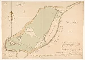
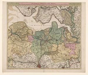
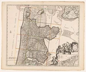
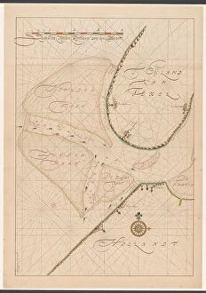
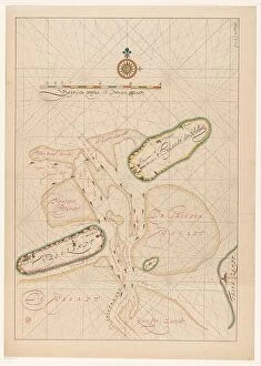
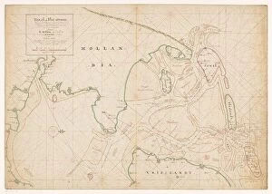
Map of Noord-Holland, Texel, Vlieland, Terschelling, part of Friesland... 1712. Creator: Isaak de Graaf
Map of Noord-Holland, Texel, Vlieland, Terschelling, part of Friesland and the surrounding sandbanks, 1712. Top left, cartouche with the title Texel en Flie-stroom (Texel and the Flie-stream)

Background imageMap Making Collection: Johan François Adriaan Cateau van Rosevelt... 1885. Creator: Lovera

Johan François Adriaan Cateau van Rosevelt... 1885. Creator: Lovera
Johan Francois Adriaan Cateau van Rosevelt, Chief of the Construction Department and Agent General of Immigration in Suriname, 1885

Background imageMap Making Collection: Frontiere greco-serbe; terrain ou s'est deployee l'offensive de septembre a la frontiere... 1916

Frontiere greco-serbe; terrain ou s'est deployee l'offensive de septembre a la frontiere... 1916
Frontiere greco-serbe; terrain ou s'est deployee l'offensive de septembre a la frontiere greco-serbe, de part et d'autre du lac d'Ostrovo. 1916. From "Collection de la Guerre IV

Background imageMap Making Collection: 'L'Imerina; Iles Africaines de la mer des Indes, 1914. Creator: Unknown

'L'Imerina; Iles Africaines de la mer des Indes, 1914. Creator: Unknown
'L'Imerina; Iles Africaines de la mer des Indes, 1914. From "Grande Geographie Bong Illustree", 1914

Background imageMap Making Collection: 'Kilima Ndjaro et Meru; Afrique Australe, 1914. Creator: Unknown

'Kilima Ndjaro et Meru; Afrique Australe, 1914. Creator: Unknown
'Kilima Ndjaro et Meru; Afrique Australe, 1914. From "Grande Geographie Bong Illustree", 1914

Background imageMap Making Collection: 'Grande vallee de fracture de lAfrique orientale; Afrique Australe, 1914. Creator: Unknown

'Grande vallee de fracture de lAfrique orientale; Afrique Australe, 1914. Creator: Unknown
'Grande vallee de fracture de lAfrique orientale; Afrique Australe, 1914. From "Grande Geographie Bong Illustree", 1914

Background imageMap Making Collection: 'Region septentrionale du Nyassa; Afrique Australe, 1914. Creator: Unknown

'Region septentrionale du Nyassa; Afrique Australe, 1914. Creator: Unknown
'Region septentrionale du Nyassa; Afrique Australe, 1914. From "Grande Geographie Bong Illustree", 1914

Background imageMap Making Collection: 'Beira. Sofala; Afrique Australe, 1914. Creator: Unknown

'Beira. Sofala; Afrique Australe, 1914. Creator: Unknown
'Beira. Sofala; Afrique Australe, 1914. From "Grande Geographie Bong Illustree", 1914

Background imageMap Making Collection: 'Lourenco-Marques; Afrique Australe, 1914. Creator: Unknown

'Lourenco-Marques; Afrique Australe, 1914. Creator: Unknown
'Lourenco-Marques; Afrique Australe, 1914. From "Grande Geographie Bong Illustree", 1914

Background imageMap Making Collection: 'Le plateau de Bihe; Afrique Australe, 1914. Creator: Unknown

'Le plateau de Bihe; Afrique Australe, 1914. Creator: Unknown
'Le plateau de Bihe; Afrique Australe, 1914. From "Grande Geographie Bong Illustree", 1914

Background imageMap Making Collection: 'Baie de Luderitz; Afrique Australe, 1914. Creator: Unknown

'Baie de Luderitz; Afrique Australe, 1914. Creator: Unknown
'Baie de Luderitz; Afrique Australe, 1914. From "Grande Geographie Bong Illustree", 1914

Background imageMap Making Collection: 'Chutes Victoria; Afrique Australe, 1914. Creator: Unknown

'Chutes Victoria; Afrique Australe, 1914. Creator: Unknown
'Chutes Victoria; Afrique Australe, 1914. From "Grande Geographie Bong Illustree", 1914


All Professionally Made to Order for Quick Shipping