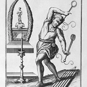
Use of the magnetic compass in map making, 1643

![]()
Wall Art and Photo Gifts from Heritage Images
Use of the magnetic compass in map making, 1643
Use of the magnetic compass in map making, 1643. Diagram of the use of the compass by cartographers and surveyors. Bor (Borealis) is north and Aust (Australis) is south. From Magnes: sive de arte magnetica by Athanasius Kircher. (Rome, 1643)
Media ID 14865934
© Oxford Science Archive / Heritage-Images
Arithmetic Athanasius Athanasius Kircher Athanasius Kirchner Cartography Compass Innovation Kircher Kirchner Athanasius Magnetic Magnetism Map Making Mathematics Maths Navigation Navigational Device North Oxford Science Archive Physics South Surveying World
MADE IN THE UK
Safe Shipping with 30 Day Money Back Guarantee
FREE PERSONALISATION*
We are proud to offer a range of customisation features including Personalised Captions, Color Filters and Picture Zoom Tools
FREE COLORIZATION SERVICE
You can choose advanced AI Colorization for this picture at no extra charge!
SECURE PAYMENTS
We happily accept a wide range of payment options so you can pay for the things you need in the way that is most convenient for you
* Options may vary by product and licensing agreement. Zoomed Pictures can be adjusted in the Basket.