mail_outline sales@mediastorehouse.com
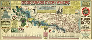
Touring map of the Custer Battlefield Hiway: the scenic route to the west, 1925. Creators: John C. Mulford, C. CTouring map of the Custer Battlefield Hiway: the scenic route to the west, 1925. The Custer Battlefield Highway was created in 1925 as a scenic route between Iowa and Montana
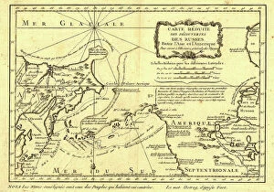
Carte re´duite des de´couvertes des Russes, entre l'Asie et l'Amerique, (1747?). This French map of Alaska, Siberia, and the North Pacific, published in 1747
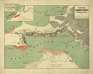
Plan Vladivostokskago torgovago porta, 1916. Creator: Ministerstvo torgovli i promyshlennostiPlan Vladivostokskago torgovago porta, 1916. Karta t?s?vetnai?a?, nakleena na tkan'. Dop. karta: Likhternai?a? gavan na beregu Amurskago zal. u Pervoi? rechki. M. [1:8 400]
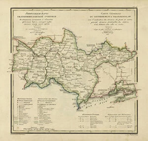
General Map of Ekaterinoslav Province: Showing Postal and Major Roads, Stations and the... 1821General Map of Ekaterinoslav Province: Showing Postal and Major Roads, Stations and the Distance in Versts between Them, 1821
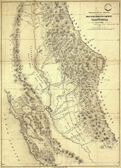
Topographical sketch of the gold & quicksilver district of California, 1848. Creator: Edward OrdTopographical sketch of the gold & quicksilver district of California, 1848. Published in July 1848 after the first gold strikes at Sutter's Mill on the American River in northern California
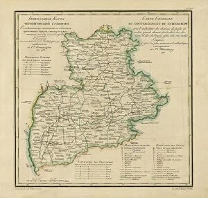
General Map of Chernigov Province: Showing Postal and Major Roads, Stations and... 1821General Map of Chernigov Province: Showing Postal and Major Roads, Stations and the Distance in Versts between Them, 1821
Millroy's map of Alaska and the Klondyke gold fields, 1897. Creator: J. J. MillroyMillroy's map of Alaska and the Klondyke gold fields, 1897. The Klondike Gold Rush of 1898 began in earnest within 18 months of a major gold strike on Bonanza Creek
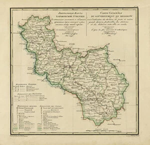
General Map of Kharkiv Province: Showing Postal and Major Roads, Stations and the... 1821General Map of Kharkiv Province: Showing Postal and Major Roads, Stations and the Distance in Versts between Them, 1821. This 1821 map of Kharkiv Provinceis from a larger work
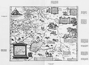
Carte de Tartarie, 1706. Creator: Guillaume DelisleCarte de Tartarie, 1706
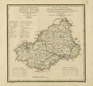
General Map of Vladimir Province: Showing Postal and Major Roads, Stations and the... 1822General Map of Vladimir Province: Showing Postal and Major Roads, Stations and the Distance in Versts between Them, 1822. This 1822 map of Vladimir Provinceis from a larger work
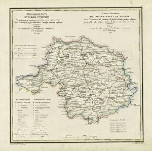
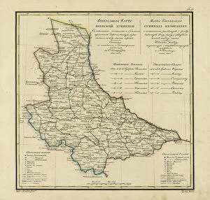
General Map of Kursk Province: Showing Postal and Major Roads, Stations and the... 1822General Map of Kursk Province: Showing Postal and Major Roads, Stations and the Distance in Versts between Them, 1822. This 1822 map of Kursk Provinceis from a larger work
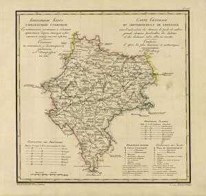
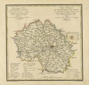
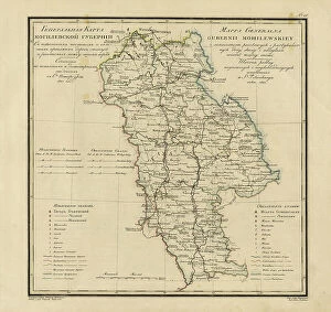
General Map of Moscow Province: Showing Postal and Major Roads, Stations and the.. 1821General Map of Moscow Province: Showing Postal and Major Roads, Stations and the Distance in Versts between Them, 1821. This 1821 map of Smolensk Provinceis from a larger work
General Map of Tver Province: Showing Postal and Major Roads, Stations and the... 1821General Map of Tver Province: Showing Postal and Major Roads, Stations and the Distance in Versts between Them, 1821. This 1821 map of Tver Provinceis from a larger work
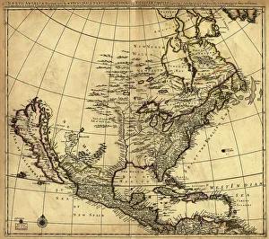
North America divided into its III principall [sic] parts, 1685. Creator: Philip LeaNorth America divided into its III principall [sic] parts, 1685. This map, North America Divided into its III Principal Parts
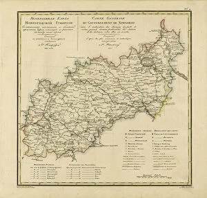
General Map of Novgorod Province: Showing Postal and Major Roads, Stations and the... 1821General Map of Novgorod Province: Showing Postal and Major Roads, Stations and the Distance in Versts between Them, 1821. This 1821 map of Novgorod Provinceis from a larger work
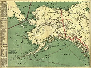
Map of the Alaskan gold fields, 1897. Creator: T. S. LeeMap of the Alaskan gold fields, 1897. Beginning in the mid-19th century, gold was discovered in a succession of strikes along the western coast of the United States in an ascending arc
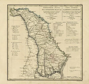
General Map of Bessarabia: Showing Postal and Major Roads, Stations and the... 1821General Map of Bessarabia: Showing Postal and Major Roads, Stations and the Distance in Versts between Them, 1821. This 1821 map of Bessarabia is from a larger work
The Five-Year Plan of New Construction of Industry of the USSR: Map of the Asiatic Part... 1930 Creator: I. AThe Five-Year Plan of New Construction of Industry of the USSR: Map of the Asiatic Part of the USSR, 1930. Supplement to the map of the Five-Year plan of the European part of the USSR
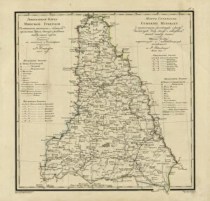
General Map of Minsk Province: Showing Postal and Major Roads, Stations and the... 1821General Map of Minsk Province: Showing Postal and Major Roads, Stations and the Distance in Versts between Them, 1821. This 1821 map of Minsk Province is from a larger work
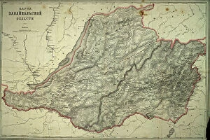
Map of Zabaikal'sk Province, Before 1914. Creator: A. IlinaMap of Zabaikal'sk Province, Before 1914
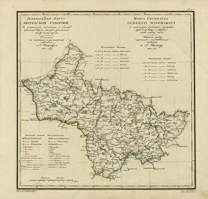
General Map of Vitebsk Province: Showing Postal and Major Roads, Stations and the... 1820General Map of Vitebsk Province: Showing Postal and Major Roads, Stations and the Distance in Versts between Them, 1820. This 1820 map of Vitebsk Provinceis from a larger work
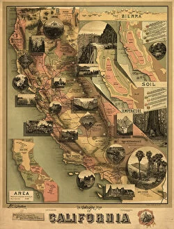
The unique map of California, 1888. Creator: E. McD. JohnstoneThe unique map of California, 1888. It was issued in 1888 by the Southern Pacific Railroad Company and the California State Board of Trade as part of a campaign to promote the economic, cultural
General Map of Moscow Province: Showing Postal and Major Roads, Stations and... 1821General Map of Moscow Province: Showing Postal and Major Roads, Stations and the Distance in Versts between Them, 1821. This 1821 map of Moscow Province is from a larger work
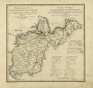
General Map of Saint Petersburg Province: Showing Postal and Major Roads, Stations and the... 1820General Map of Saint Petersburg Province: Showing Postal and Major Roads, Stations and the Distance in Versts between Them, 1820
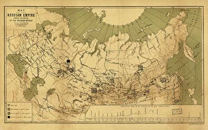
Map of the Russian Empire showing the regions of the precious metals, 1890. Creator: A. JlyneMap of the Russian Empire showing the regions of the precious metals, 1890
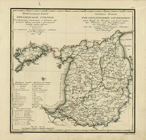
General Map of Livland Province: Showing Postal and Major Roads, Stations and the... 1820General Map of Livland Province: Showing Postal and Major Roads, Stations and the Distance in Versts between Them, 1820. This 1820 map of Livland Provinceis from a larger work
Russiae, Moskoviae et Tartariae descriptio, 1562. Creator: Anthony JenkinsonRussiae, Moskoviae et Tartariae descriptio, 1562. No. 1 Karta iz izdaniia: Atlas Aziatskoi Rossii.- SPb. Pereselencheskoe Upravlenie, kartogr. art. Zav. A.F. Marks, 1914
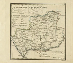
General Map of Kherson Province: Showing Postal and Major Roads, Stations and... 1821General Map of Kherson Province: Showing Postal and Major Roads, Stations and the Distance in Versts between Them, 1821. This 1821 map of Kherson Provinceis from a larger work
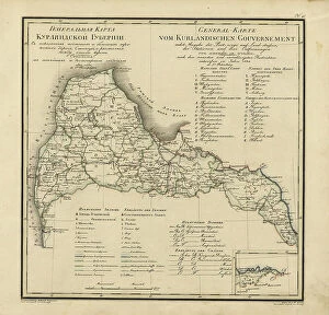
General Map of Courland Province: Showing Postal and Major Roads, Stations and the... 1820General Map of Courland Province: Showing Postal and Major Roads, Stations and the Distance in Versts between Them, 1820. This 1820 map of Courland Province is from a larger work
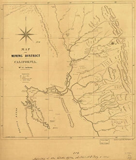
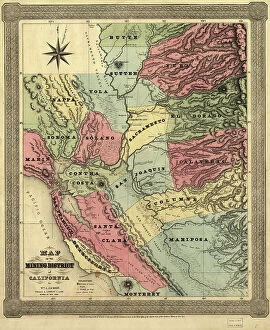
Map of the mining district of California, 1850. Creator: William A. JacksonMap of the mining district of California, 1850. The California gold rush of 1849 began with the strikes at Sutter's Mill on the American River near Sacramento
General Map of Kiev Province: Showing Postal and Major Roads, Stations and.. 1821General Map of Kiev Province: Showing Postal and Major Roads, Stations and the Distance in Versts between Them, 1821. This 1821 map of Kiev Province is from a larger work
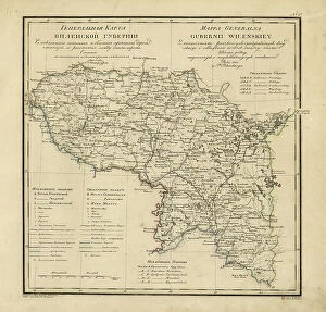
General Map of Vilnius Province: Showing Postal and Major Roads, Stations and the... 1820General Map of Vilnius Province: Showing Postal and Major Roads, Stations and the Distance in Versts between Them, 1820. This 1820 map of Vilnius Provinceis from a larger work
Map of the mining district of California, 1851. Creator: William A. JacksonMap of the mining district of California, 1851. This map, produced in two parts in the early years after the California Gold Rush of 1849
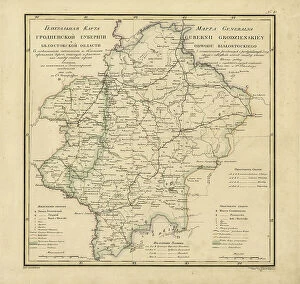
General Map of Grodno Province and the Belostok Region: Showing Postal and Major Roads... 1820General Map of Grodno Province and the Belostok Region: Showing Postal and Major Roads, Stations and the Distance in Versts between Them, 1820
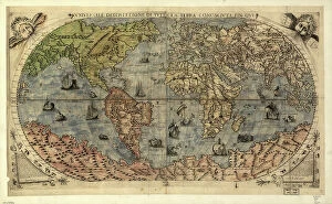
Vniversale descrittione di tvtta la terra conoscivta fin qvi, 1565. Creators: Paolo Forlani, Ferrando BertelliVniversale descrittione di tvtta la terra conoscivta fin qvi, 1565. Relief shown pictorially. Based on an earlier map by Giacomo Gastaldi. From the Rosenwald Collection, Library of Congress, no
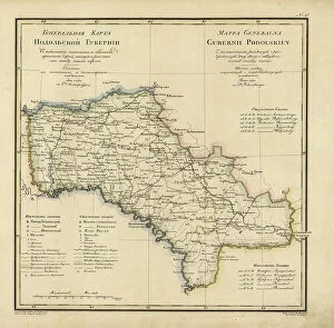
General Map of Podolsk Province: Showing Postal and Major Roads, Stations and the... 1820General Map of Podolsk Province: Showing Postal and Major Roads, Stations and the Distance in Versts between Them, 1820. This 1820 map of Podolsk Provinceis from a larger work
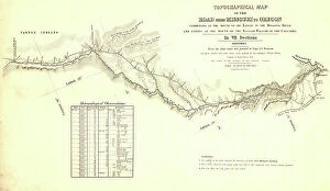
Topographical map of the road from Missouri to Oregon, commencing at the mouth of the Kansas...1846 CreatorsTopographical map of the road from Missouri to Oregon, commencing at the mouth of the Kansas in the Missouri River and ending at the mouth of the Walla-Wallah in the Columbia, 1846
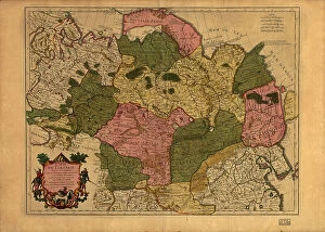
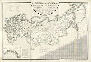
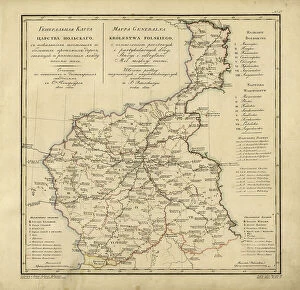
General Map of the Russian Empire and the Neighboring Polish.. 1827. Creators: Vasilii Petrovich Piadyshev, IereminGeneral Map of the Russian Empire and the Neighboring Polish Empire and Grand Duchy of Finland: With the Distance in Versts on Postal Roads between Provincial Cities;
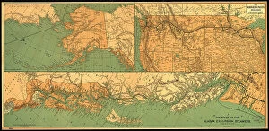
The route of the Alaska excursion steamers, 1891. Creator: Charles Sumner FeeThe route of the Alaska excursion steamers, 1891. This map, published in 1891, shows the excursion steamship routes from Seattle
General Map of Yaroslavl Province: Showing Postal and Major Roads, Stations and the... 1822General Map of Yaroslavl Province: Showing Postal and Major Roads, Stations and the Distance in Versts between Them, 1822
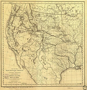
Map of the Trans-Mississippi of the United States during the period of the American fur... 1902Map of the Trans-Mississippi of the United States during the period of the American fur trade as conducted from St. Louis between the years 1807 and 1843, 1902. This map, published in 1902 in H.M
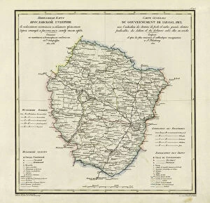
General Map of Mogilev Province: Showing Postal and Major Roads, Stations and... 1821General Map of Mogilev Province: Showing Postal and Major Roads, Stations and the Distance in Versts between Them, 1821. This 1821 map of Mogilev Provinceis from a larger work
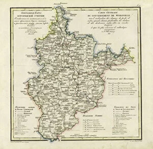
General Map of Voronezh Province: Showing Postal and Major Roads, Stations and the... 1822General Map of Voronezh Province: Showing Postal and Major Roads, Stations and the Distance in Versts between Them, 1822. This 1822 map of Voronezh Provinceis from a larger work
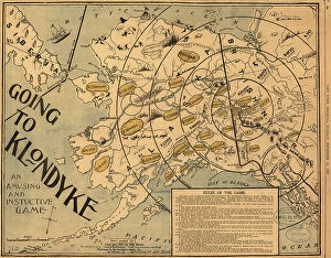
Going to Klondyke, 1897. Creator: May BloomGoing to Klondyke, 1897. The Klondike Gold Rush of 1898 was one of the largest gold frenzies in history. Tens of thousands of prospectors from around the world streamed north to Alaska
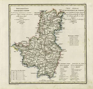
General Map of Tambov Province: Showing Postal and Major Roads, Stations and the... 1822General Map of Tambov Province: Showing Postal and Major Roads, Stations and the Distance in Versts between Them, 1822. This 1822 map of Tambov Provinceis from a larger work
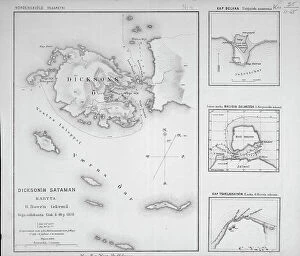
Dickson'in sataman. Kartta. G. Boven tekema, 1878. Creator: G. BovenDickson'in sataman. Kartta. G. Boven tekema, 1878. Dikson, o-v. Karta puteshestvii?a? Nordenshel'da na karable "Vega" u beregov Diksona v 1878 godu
General Map of the Polish Empire: Showing Postal and Major Roads, Stations and the... 1820General Map of the Polish Empire: Showing Postal and Major Roads, Stations and the Distance in Miles Between Them, 1820. This 1820 map of the Polish Empire, then part of the Russian Empire
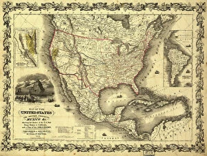
Map of the United States, the British provinces, Mexico &c. 1849. Creator: John M. AtwoodMap of the United States, the British provinces, Mexico &c. 1849. Shows California's gold region and western trails. Includes illustration of "Pyramid Lake