mail_outline sales@mediastorehouse.com
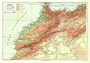
Relief Map of Maroc, 1914. Creator: UnknownRelief Map of Maroc, 1914. From "Grande Geographie Bong Illustree", 1914
Relief Map of Tunisie, 1914. Creator: UnknownRelief Map of Tunisie, 1914. From "Grande Geographie Bong Illustree", 1914
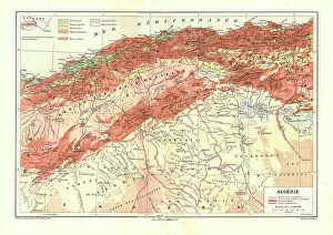
Relief Map of Algerie, 1914. Creator: UnknownRelief Map of Algerie, 1914. From "Grande Geographie Bong Illustree", 1914
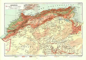
Relief Map of Berberie, 1914. Creator: UnknownRelief Map of Berberie, 1914. From "Grande Geographie Bong Illustree", 1914
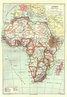
Map of Afrique showing Possessions et protectorats d'Europe, 1914. Creator: UnknownMap of Afrique showing Possessions et protectorats d'Europe, 1914. From "Grande Geographie Bong Illustree", 1914
Sur le front des balkans. -- Vue panaoramique du terrain des operations dans les Balkans... 1916. Creator: L. TrinquierSur le front des balkans. -- Vue panaoramique du terrain des operations dans les Balkans, de Doiran a Florina et a Kastoria. 1916. From "Collection de la Guerre IV
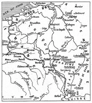
Du front a Essen. -- Les noms soulignes sont ceux de points bombardes par nos escadrilles, 1916. Creator: UnknownDu front a Essen. -- Les noms soulignes sont ceux de points bombardes par nos escadrilles. 1916. From "Collection de la Guerre IV. L'Illustration Tome CXLVII
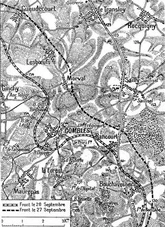
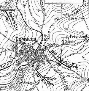
Terrain de l'operation combinee franco-britannique de part et d'autre de Combles, 1916. Creator: UnknownTerrain de l'operation combinee franco-britannique de part et d'autre de Combles. 1916. From "Collection de la Guerre IV. L'Illustration Tome CXLVII
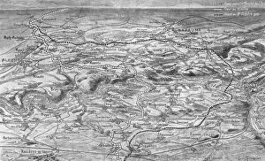
Les progres de l'offensive Franco-Britannique sur la Somme; Trace approximatif sur le... 1916. Creator: LLes progres de l'offensive Franco-Britannique sur la Somme; Trace approximatif sur le terrain du nouveau front apres la prise de Combles et de Thiepval. 1916
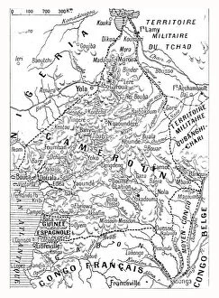
Le Cameroun Francais; Carte du Cameroun franco-britannique, 1916. Creator: UnknownLe Cameroun Francais; Carte du Cameroun franco-britannique. 1916. From "Collection de la Guerre IV. L'Illustration Tome CXLVII
L'offensive de la Somme; L'avance franco-britannique sur la Somme a la date 20 septembre, 1916L'offensive de la Somme; L'avance franco-britannique sur la Somme a la date 20 septembre. 1916. From "Collection de la Guerre IV. L'Illustration Tome CXLVII
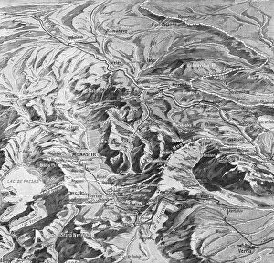
La Campagne Macedonienne; De Salonique a Monastir, 1916. Creator: UnknownLa Campagne Macedonienne; De Salonique a Monastir. 1916. From "Collection de la Guerre IV. L'Illustration Tome CXLVII
La bataille de la Somme; La prise de Combles, 1916. Creator: UnknownLa bataille de la Somme; La prise de Combles. 1916. From "Collection de la Guerre IV. L'Illustration Tome CXLVII. La Guerre Juillet, Aout, Septembre, Octobre, Novembre, Decembre 1916"
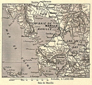
Baie de Manille; Les Terres Du Pacifique, 1914. Creator: UnknownBaie de Manille; Les Terres Du Pacifique, 1914. From "Grande Geographie Bong Illustree", 1914
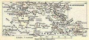
Detroit de San Bernardino; Les Terres Du Pacifique, 1914. Creator: UnknownDetroit de San Bernardino; Les Terres Du Pacifique, 1914. From "Grande Geographie Bong Illustree", 1914
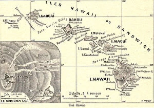
Iles Hawai; Les Terres Du Pacifique, 1914. Creator: UnknownIles Hawai; Les Terres Du Pacifique, 1914. From "Grande Geographie Bong Illustree", 1914
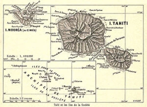
Tahiti et les iles de la Societe; Les Terres Du Pacifique, 1914. Creator: UnknownTahiti et les iles de la Societe; Les Terres Du Pacifique, 1914. From "Grande Geographie Bong Illustree", 1914
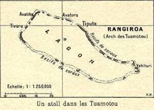
Un atoll dans les Tuamotou; Les Terres Du Pacifique, 1914. Creator: UnknownUn atoll dans les Tuamotou; Les Terres Du Pacifique, 1914. From "Grande Geographie Bong Illustree", 1914
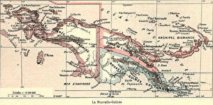
La Nouvelle-Guinee; Les Terres Du Pacifique, 1914. Creator: UnknownLa Nouvelle-Guinee; Les Terres Du Pacifique, 1914. From "Grande Geographie Bong Illustree", 1914
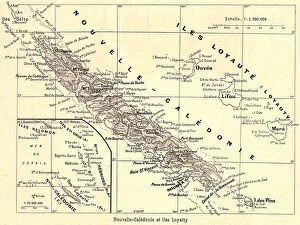
Nouvelle-Caledonie et iles Loyalty; Les Terres Du Pacifique, 1914. Creator: UnknownNouvelle-Caledonie et iles Loyalty; Les Terres Du Pacifique, 1914. From "Grande Geographie Bong Illustree", 1914
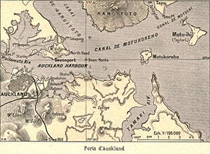
Ports d'Auckland; Les Terres Du Pacifique, 1914. Creator: UnknownPorts d'Auckland; Les Terres Du Pacifique, 1914. From "Grande Geographie Bong Illustree", 1914
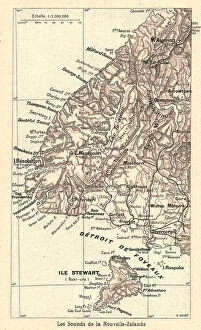
Les Sounds de la Nouvelle-Zelande; Les Terres Du Pacifique, 1914. Creator: UnknownLes Sounds de la Nouvelle-Zelande; Les Terres Du Pacifique, 1914. From "Grande Geographie Bong Illustree", 1914
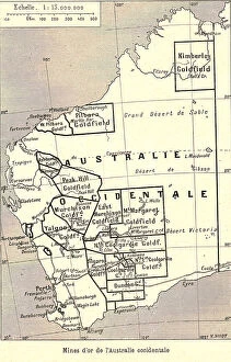
Mines d'or de l'Australie occidentale; Les Terres Du Pacifique, 1914. Creator: UnknownMines d'or de l'Australie occidentale; Les Terres Du Pacifique, 1914. From "Grande Geographie Bong Illustree", 1914
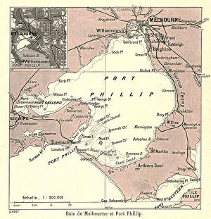
Baie de Melbourne et Port Phillip; Les Terres Du Pacifique, 1914. Creator: UnknownBaie de Melbourne et Port Phillip; Les Terres Du Pacifique, 1914. From "Grande Geographie Bong Illustree", 1914
Sydney et Botany-Bay; Les Terres Du Pacifique, 1914. Creator: UnknownSydney et Botany-Bay; Les Terres Du Pacifique, 1914. From "Grande Geographie Bong Illustree", 1914
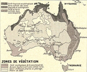
Australie Zones de Vegetation; Les Terres Du Pacifique, 1914. Creator: UnknownAustralie Zones de Vegetation; Les Terres Du Pacifique, 1914. From "Grande Geographie Bong Illustree", 1914
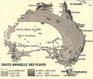
Australie Chute Annuelle des Pluies; Les Terres Du Pacifique, 1914. Creator: UnknownAustralie Chute Annuelle des Pluies; Les Terres Du Pacifique, 1914. From "Grande Geographie Bong Illustree", 1914
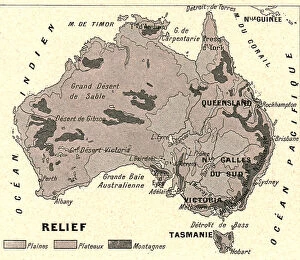
Australie Relief; Les Terres Du Pacifique, 1914. Creator: UnknownAustralie Relief; Les Terres Du Pacifique, 1914. From "Grande Geographie Bong Illustree", 1914
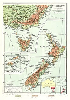
Australie Meridionale et Tasmanie. Iles Fidji ou Viti. Nouvelle- Zelande; Les Terres Du... 1914. Creator: UnknownAustralie Meridionale et Tasmanie. Iles Fidji ou Viti. Nouvelle- Zelande; Les Terres Du Pacifique, 1914. From "Grande Geographie Bong Illustree", 1914
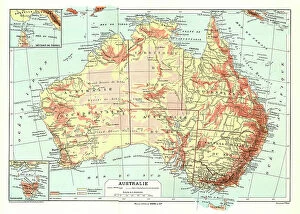
Australie; Les Terres Du Pacifique, 1914. Creator: UnknownAustralie; Les Terres Du Pacifique, 1914. From "Grande Geographie Bong Illustree", 1914
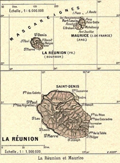
La Reunion et Maurice; Iles Africaines de la mer des Indes, 1914. Creator: UnknownLa Reunion et Maurice; Iles Africaines de la mer des Indes, 1914. From "Grande Geographie Bong Illustree", 1914
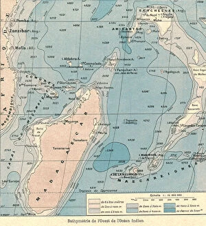
Bathymetrie de l'Ouest de l'Ocean Indien; Iles Africaines de la mer des Indes, 1914. Creator: UnknownBathymetrie de l'Ouest de l'Ocean Indien; Iles Africaines de la mer des Indes, 1914. From "Grande Geographie Bong Illustree", 1914
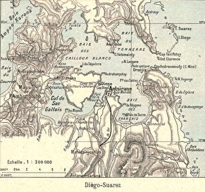
Diego- Suarez; Iles Africaines de la mer des Indes, 1914. Creator: UnknownDiego- Suarez; Iles Africaines de la mer des Indes, 1914. From "Grande Geographie Bong Illustree", 1914
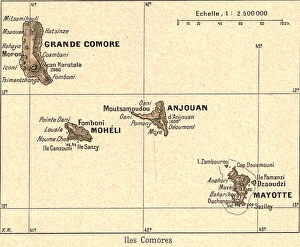
Iles Comores; Iles Africaines de la mer des Indes, 1914. Creator: UnknownIles Comores; Iles Africaines de la mer des Indes, 1914. From "Grande Geographie Bong Illustree", 1914
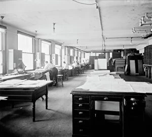
Geological Survey art room, between 1910 and 1920. Creator: Harris & EwingGeological Survey art room, [Washington, DC], between 1910 and 1920. [Map-making]
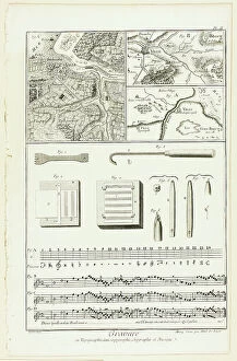
Topographic, Geographic and Music Engraving, from Encyclopédie, 1762/77. Creators: A. J. Defehrt, Madame de LusseTopographic, Geographic and Music Engraving, from Encyclopedie, 1762/77
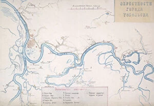
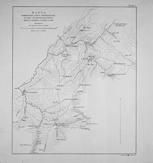
Map of the Irtysh region from the village of Zashchitina to the Epanchinsky yurts... 1880. Creator: Mikhail ZnamenskyMap of the Irtysh region from the village of Zashchitina to the Epanchinsky yurts, 1880. The third page of the album "Walks through the historical environs of the city of Tobolsk.", 1880
Map of the Nerchinsk Region from the Office of His Majesty, 1914. CreatorMap of the Nerchinsk Region from the Office of His Majesty, 1914. From the atlas "Atlas of Asian Russia."
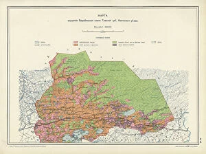
Map on the drainage of the Barabinsk steppe in the Tomsk province, Kainsk district, 1914. From the atlas "Atlas of Asian Russia."
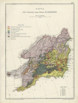
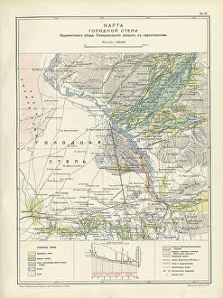
Map of the barren steppe of the Khodzhentsk distric, Samarkand region, with its environs, 1914. From the atlas "Atlas of Asian Russia."
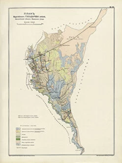
Plan Murgabskogo Gosudareva imeniia, Zakaspiiskoi oblasti, Mervskogo uezda, 1914. From the atlas "Atlas of Asian Russia."
Map of the Altai Region from the Office of His Majesty, 1914. Creator: Resettlement Department of the Land RegulationMap of the Altai Region from the Office of His Majesty, 1914. From the atlas "Atlas of Asian Russia."
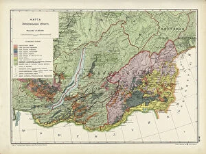
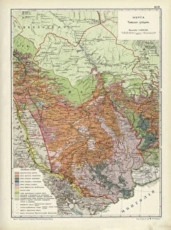
Map of Zabaikal Province, 1914. Creator: Resettlement Department of the Land Regulation and Agriculture AdministrationMap of Zabaikal Province, 1914. From the atlas "Atlas of Asian Russia."
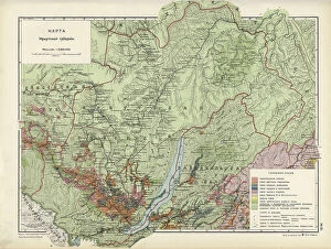
Map of Enisei Province, 1914. Creator: Resettlement Department of the Land Regulation and Agriculture AdministrationMap of Enisei Province, 1914. From the atlas "Atlas of Asian Russia."
Map of Irkutsk Province, 1914. Creator: Resettlement Department of the Land Regulation and Agriculture AdministrationMap of Irkutsk Province, 1914. From the atlas "Atlas of Asian Russia."
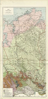
Map of Tomsk Province, 1914. Creator: Resettlement Department of the Land Regulation and Agriculture AdministrationMap of Tomsk Province, 1914. From the atlas "Atlas of Asian Russia."
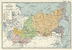
Map of the Military Districts of Asiatic Russia, 1914. Creator: Resettlement Department of the Land RegulationMap of the Military Districts of Asiatic Russia, 1914. From the atlas "Atlas of Asian Russia."
Map of exploration work carried out in 1895 in the Mariinsky District. Ubienka.. 1895. Creator: UnknownMap of exploration work carried out in 1895 in the Mariinsky District. Ubienka, B. Barandat, lake; Pike and so on, 1895