mail_outline sales@mediastorehouse.com
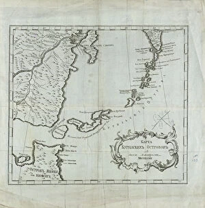
Map of the Kuril Islands with Surrounding Areas, 1700-1799. Creator: UnknownMap of the Kuril Islands with Surrounding Areas, 1700-1799. This 18th century Russian map depicts the Kurile Islands archipelago, located on the far eastern edge of the Russian Empire
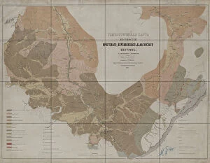
Geognostic Map of the Localities of Irkutsk, Verkholensk, and Balagansk Districts, 1873. The first geological (geognostic) maps in Russia were produced in the 1850s
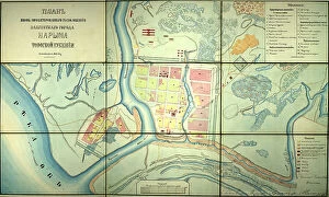
Plan of the newly designed location of the provincial town of Narym, Tomsk province, 1868. Creator: UnknownPlan of the newly designed location of the provincial town of Narym, Tomsk province, 1868
Projecting Plan of a District City Tomsk, Made in 1872, 1873. Creator: UnknownProjecting Plan of a District City Tomsk, Made in 1872, 1873
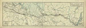
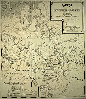
Map of the Route of the Siberian Railway Line, 1891-1916.. Creator: UnknownMap of the Route of the Siberian Railway Line, 1891-1916
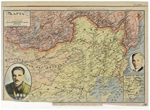
Map of the Far East of the USSR, Northern China (Manchuria) and Mongolia, 1930. Creator: UnknownMap of the Far East of the USSR, Northern China (Manchuria) and Mongolia, 1930. This Soviet-era map is intended to serve a propaganda purpose
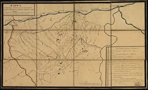
Karta I?A?kutskoi? oblasti chasti Olekminskago okruga i Irkutskoi? guberni¯i? Kirenskogo... 1853. Creator: UnknownKarta I?A?kutskoi? oblasti chasti Olekminskago okruga i Irkutskoi? guberni¯i? Kirenskogo [sic] chast okrugas pokazani¯em zolotosoderzhashchikh pri¯i?skov razrabatyvaemyi?a? : gg
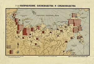
The direction of reindeer husbandry and dog breeding, 1932. Creator: UnknownThe direction of reindeer husbandry and dog breeding, 1932. Conventional signs: adult reindeer with the distinction of sled dogs, adult dogs with the distinction of sled dogs, herding dogs
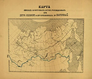
[Karty pochtovykh soobshcheni¯i? uchrezhdennykh v Rossi¯i?skoi? Imperi¯i pri T?S?ari?e... (186-?). Creator: Unknown[Karty pochtovykh soobshcheni¯i? uchrezhdennykh v Rossi¯i?skoi? Imperi¯i pri T?S?ari?e? Aleksi?e?i?e? Mikhailovichi?e? i ego preemnikakh do Ekateriny II], (186-?)
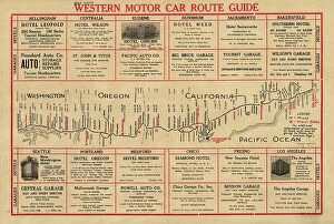
Western motor car route guide, (1915?). Creator: UnknownWestern motor car route guide, (1915?). This automobile guide shows the main highway route between Vancouver, Canada, and San Diego, California, circa 1915
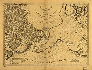
The Russian discoveries from the map published by the Imperial Academy of St. Petersburg, 1775. Creator: UnknownThe Russian discoveries from the map published by the Imperial Academy of St. Petersburg, 1775. This map, showing the known geography of Alaska in the late 18th century
Kartogramma "grippa" : [Russia], 1890. Creator: Unknown. Kartogramma "grippa" : [Russia], 1890Kartogramma "grippa" : [Russia], 1890. Shows occurrence of influenza by province. Each map has a number at head of title, and a month or months at the end of the title: No. 50
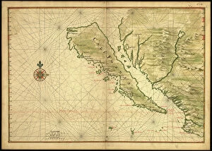
Map of California shown as an island, c 1650. Creator: Johannes VingboonsMap of California shown as an island, c 1650. This map from around 1650 shows California as an island. A half-century would pass before Spanish explorers determined with certainty that California was
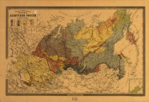
E?tnograficheskai?a? karta Azi¯i?a?tskoi? Rossi¯i, (187-?). Creator: Mikhail VeniukovE?tnograficheskai?a? karta Azi¯i?a?tskoi? Rossi¯i, (187-?). Pulkovo meridian
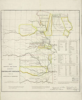
Map showing the lands assigned to emigrant Indians west of Arkansas and Missouri, 1836. Creator: Topographical BureauMap showing the lands assigned to emigrant Indians west of Arkansas and Missouri, 1836. Following passage of the Indian Removal Act in 1830
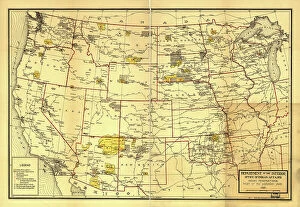
Indian Reservations west of the Mississippi River, 1923. Creator: Office of Indian AffairsIndian Reservations west of the Mississippi River, 1923. This map, created by the Office of Indian Affairs in 1923, shows the location of Indian reservations west of the Mississippi River
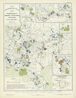
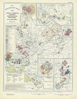
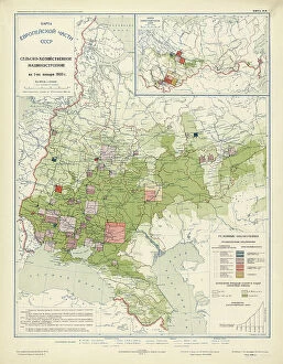
Industry of binding building materials on January 1, 1933, 1934. Creator: Mikhail Alekseevich TSvetkovIndustry of binding building materials on January 1, 1933, 1934. From the atlas "Industry of the USSR at the beginning of the 2nd Five-Year Plan
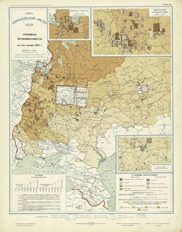
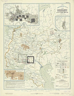
Extraction and primary processing of non-metallic minerals as of January 1, 1933, 1934. From the atlas "Industry of the USSR at the beginning of the 2nd Five-Year Plan
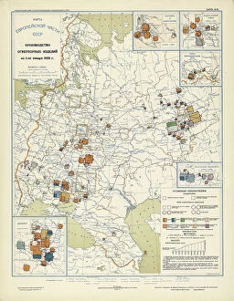
Production of refractory products on January 1, 1933, 1934. Creator: Mikhail Alekseevich TSvetkovProduction of refractory products on January 1, 1933, 1934. From the atlas "Industry of the USSR at the beginning of the 2nd Five-Year Plan
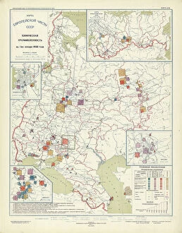
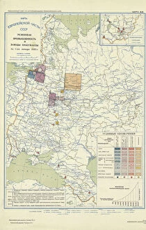
Chemical industry of the USSR on January 1, 1933, 1934. Creator: Mikhail Alekseevich TSvetkovChemical industry of the USSR on January 1, 1933, 1934. From the atlas "Industry of the USSR at the beginning of the 2nd Five-Year Plan
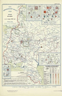
Precision mechanics on January 1, 1933, 1934. Creator: Mikhail Alekseevich TSvetkovPrecision mechanics on January 1, 1933, 1934. From the atlas "Industry of the USSR at the beginning of the 2nd Five-Year Plan
Agricultural engineering as of January 1, 1933, 1934. Creator: Mikhail Alekseevich TSvetkovAgricultural engineering as of January 1, 1933, 1934. From the atlas "Industry of the USSR at the beginning of the 2nd Five-Year Plan
Automotive and tractor manufacturing on January 1, 1933, 1934. Creator: Mikhail Alekseevich TSvetkovAutomotive and tractor manufacturing on January 1, 1933, 1934. From the atlas "Industry of the USSR at the beginning of the 2nd Five-Year Plan
General mechanical engineering on January 1, 1933, 1934. Creator: Mikhail Alekseevich TSvetkovGeneral mechanical engineering on January 1, 1933, 1934. From the atlas "Industry of the USSR at the beginning of the 2nd Five-Year Plan
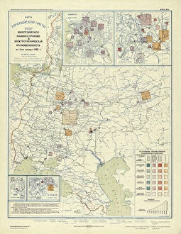
Power engineering and electrical industry as of January 1, 1933, 1934. Creator: Mikhail Alekseevich TSvetkovPower engineering and electrical industry as of January 1, 1933, 1934. From the atlas "Industry of the USSR at the beginning of the 2nd Five-Year Plan
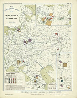
Non-ferrous metallurgy on January 1, 1933, 1934. Creator: Mikhail Alekseevich TSvetkovNon-ferrous metallurgy on January 1, 1933, 1934. From the atlas "Industry of the USSR at the beginning of the 2nd Five-Year Plan
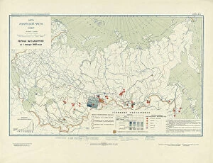
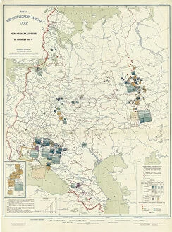
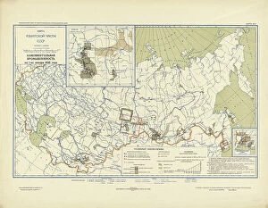
Ferrous metallurgy on January 1, 1933, 1934. Creator: Mikhail Alekseevich TSvetkovFerrous metallurgy on January 1, 1933, 1934. From the atlas "Industry of the USSR at the beginning of the 2nd Five-Year Plan
Peat industry on January 1, 1933, 1934. Creator: Mikhail Alekseevich TSvetkovPeat industry on January 1, 1933, 1934. From the atlas "Industry of the USSR at the beginning of the 2nd Five-Year Plan
Oil industry on January 1, 1933, 1934. Creator: Mikhail Alekseevich TSvetkovOil industry on January 1, 1933, 1934. From the atlas "Industry of the USSR at the beginning of the 2nd Five-Year Plan
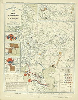
Coal industry on January 1, 1933, 1934. Creator: Mikhail Alekseevich TSvetkovCoal industry on January 1, 1933, 1934. From the atlas "Industry of the USSR at the beginning of the 2nd Five-Year Plan
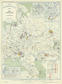
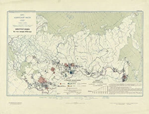
Power plants on January 1, 1933, 1934. Creator: Mikhail Alekseevich TSvetkovPower plants on January 1, 1933, 1934. From the atlas "Industry of the USSR at the beginning of the 2nd Five-Year Plan
Power Plants, 1934. Creator: Mikhail Alekseevich TSvetkovPower Plants, 1934. From the atlas "Industry of the USSR at the beginning of the 2nd Five-Year Plan. Geographical atlas." Conventional signs: borders (5 types), settlements (7 groups)
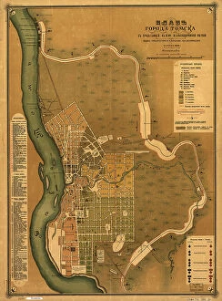
Plan goroda Tomskas prilegai?u?shchei? k nemu zheli?e?znodorozhnoi? vi?e?tv'i?u?, 1898. Creators: M. NPlan goroda Tomskas prilegai?u?shchei? k nemu zheli?e?znodorozhnoi? vi?e?tv'i?u?, 1898. Scale 1:16, 800; Relief shown by land form drawings. Russian. Shows wards and fire districts
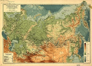
Gipsometricheskai?a? karta Rossi¯i?skoi? Imperi¯i : (opyt izobrazheni¯i?a? rel'efa Imperi¯i), (1912)Gipsometricheskai?a? karta Rossi¯i?skoi? Imperi¯i : (opyt izobrazheni¯i?a? rel'efa Imperi¯i), (1912?). Relief and depths shown by gradient tints. Also shows railroads. In Russian. Pulkovo (St)
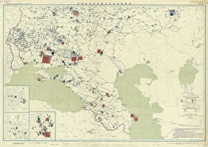
Atlas of the Yakut ASSR (Autonomous Soviet Socialist Republic). Socialist Yakutia, 1982. Creator: Soviet UnionAtlas of the Yakut ASSR (Autonomous Soviet Socialist Republic). Socialist Yakutia, 1982. This atlas was published in 1982 for the commemoration of the 60th anniversary of the formation of the Soviet
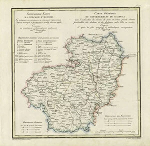
General Map of Kaluga Province: Showing Postal and Major Roads, Stations and... 1822General Map of Kaluga Province: Showing Postal and Major Roads, Stations and the Distance in Versts between Them, 1822. This 1822 map of Kaluga Province is from a larger work
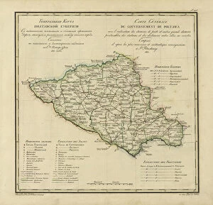
General Map of Poltava Province: Showing Postal and Major Roads, Stations and... 1821General Map of Poltava Province: Showing Postal and Major Roads, Stations and the Distance in Versts between Them, 1821. This 1821 map of Poltava Provinceis from a larger work
Map of Baikal, a Sea, a Lake, or an Angara Gap, Located in the Irkutsk Province... 1814. Creator: UnknownMap of Baikal, a Sea, a Lake, or an Angara Gap, Located in the Irkutsk Province with All the Neighboring [Territory], Whose Mathematical Measurements were Completed and it Became Fully Known in 1806
Map of inland waterways under the jurisdiction of the Tomsk district, 1800. Creator: UnknownMap of inland waterways under the jurisdiction of the Tomsk district, 1800
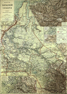
Map of Western Siberia, 1899-1914. Creator: Veniamin PetrovichMap of Western Siberia, 1899-1914
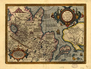
Tartariae sive Magni Chami Regni ty¨pus, 1603. Creators: Abraham Ortelius, Jan Baptist VrientsTartariae sive Magni Chami Regni ty¨pus, 1603. Covers northern Asia. Relief shown pictorially. From Abraham Ortelius's atlas: Theatrvm Orbis Terrarvm, 1603 ed. Hand col
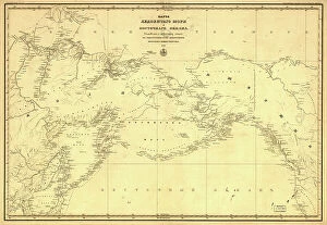
Karta Ledovitago mori?a? i Vostochnago okeana, 1844. Creator: UnknownKarta Ledovitago mori?a? i Vostochnago okeana, 1844. Depths shown by soundings in coastal waters. Also covers Russian Far East and Alaska
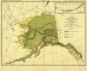
Map of Alaska and adjoining regions, 1882. Creator: Ivan PetrofMap of Alaska and adjoining regions, 1882. This multi-sheet map was produced by Ivan Petroff (also seen as Petroof and Petrof), a U.S
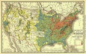
Rand, McNally & Co.'s map of the United States showing, in six degrees the density of pop... 1890Rand, McNally & Co.'s map of the United States showing, in six degrees the density of population, 1890, (1892). This map, published in 1892 by the Chicago-based Rand McNally and Company
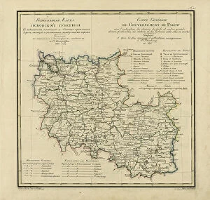
General Map of Pskov Province: Showing Postal and Major Roads, Stations and the Distance... 1820General Map of Pskov Province: Showing Postal and Major Roads, Stations and the Distance in Versts between Them, 1820. This 1820 map of Pskov Provinceis from a larger work
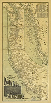
Map showing routes of the Pacific coast Steamship Company, 1891. Creator: Rand McNallyMap showing routes of the Pacific coast Steamship Company, 1891. This foldable tourist brochure, published by Rand McNally and Company in 1891