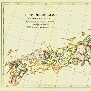
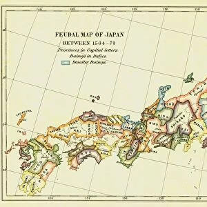
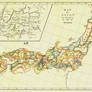
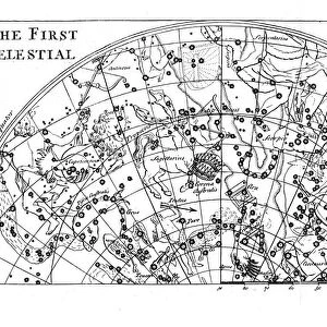
Photographic Print : Feudal Map of Japan in 1615, (1903). Creator: Unknown
. Creator: Unknown")
![]()
Photo Prints from Heritage Images
Feudal Map of Japan in 1615, (1903). Creator: Unknown
Feudal Map of Japan in 1615, (1903). The feudal period of Japanese history was a time when powerful families (daimyo) and military warlords (shogun) ruled Japan. Under control of the Tokugawa shogunate, the Edo period (1600-1868) was characterized by relative peace and stability. From A History of Japan during the century of early foreign intercourse (1542-1651) by James Murdoch, M.A. and Isoh Yamagata. [Kobe, Japan, 1903]
Media ID 19668255
© The Print Collector/Heritage Images
Cartography Control Daimyo Division Edo Bakufu Feudal Feudalism Government Hideyoshi Toyotomi Island Isoh Isoh Yamagata James Murdoch Jurisdiction Map Making Murdoch Murdoch James Nobunaga Oda Oda Nobunaga Pacific Ocean Power Tokugawa Bakufu Tokugawa Shogunate Toyotomi Hideyoshi Unification Yamagata Yamagata Isoh
11"x8.5" Photo Print
Photo prints are produced on Kodak professional photo paper resulting in timeless and breath-taking prints which are also ideal for framing. The colors produced are rich and vivid, with accurate blacks and pristine whites, resulting in prints that are truly timeless and magnificent. Whether you're looking to display your prints in your home, office, or gallery, our range of photographic prints are sure to impress. Dimensions refers to the size of the paper in inches.
Our Photo Prints are in a large range of sizes and are printed on Archival Quality Paper for excellent colour reproduction and longevity. They are ideal for framing (our Framed Prints use these) at a reasonable cost. Alternatives include cheaper Poster Prints and higher quality Fine Art Paper, the choice of which is largely dependant on your budget.
Estimated Image Size (if not cropped) is 27.9cm x 19.2cm (11" x 7.6")
Estimated Product Size is 27.9cm x 21.6cm (11" x 8.5")
These are individually made so all sizes are approximate
Artwork printed orientated as per the preview above, with landscape (horizontal) orientation to match the source image.
MADE IN THE USA
Safe Shipping with 30 Day Money Back Guarantee
FREE PERSONALISATION*
We are proud to offer a range of customisation features including Personalised Captions, Color Filters and Picture Zoom Tools
SECURE PAYMENTS
We happily accept a wide range of payment options so you can pay for the things you need in the way that is most convenient for you
* Options may vary by product and licensing agreement. Zoomed Pictures can be adjusted in the Cart.