Geographical map of the north-eastern section of India, early 20th century

![]()
Wall Art and Photo Gifts from Heritage Images
Geographical map of the north-eastern section of India, early 20th century
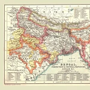
Geographical map of the north-eastern section of India, early 20th century. Pre-partition map showing the Bay of Bengal and the Ganges Delta, and what are now Bangladesh and Myanmar. Plate 57 from The Times Atlas
Media ID 15464834
© The Print Collector / Heritage-Images
Bay Of Bengal Burma Cartography Ganges Indian Ocean Map Making Myanmar River Ganges
MADE IN THE UK
Safe Shipping with 30 Day Money Back Guarantee
FREE PERSONALISATION*
We are proud to offer a range of customisation features including Personalised Captions, Color Filters and Picture Zoom Tools
SECURE PAYMENTS
We happily accept a wide range of payment options so you can pay for the things you need in the way that is most convenient for you
* Options may vary by product and licensing agreement. Zoomed Pictures can be adjusted in the Basket.