mail_outline sales@mediastorehouse.com
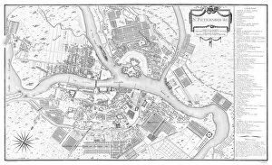
Map of Saint Petersburg, 1783. Creator: Tardieu, Pierre Francois (1752-1798)Map of Saint Petersburg, 1783. Private Collection
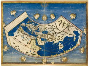
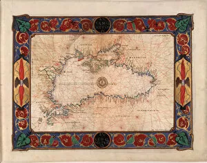
Atlas of Borso d Este, ca 1466-1467. Creator: Germanus, Donnus Nicolaus (ca. 1420-caAtlas of Borso d Este, ca 1466-1467. Found in the collection of Biblioteca Estense Universitaria, Modena
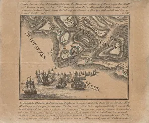
Map of the capture of the sea fortress Anapa by Russian troops on the Black Sea in June 1791, 1791. Private Collection
Naval battle between the Russian and Ottoman fleets on June 22, 1788, 1788. Private Collection
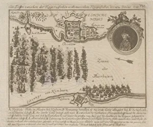
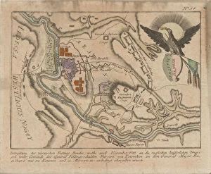
Plan of the siege of the Turkish fortress of Bender by the Russian army in November 1789, 1789. Private Collection
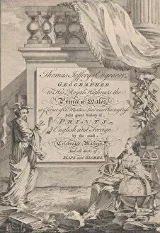
Trade Card for Thomas Jefferys, Engraver, Geographer, and Printseller, 18th century
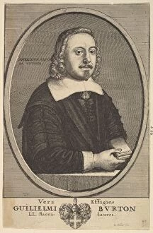
Vera Effigies Guilielmi Burton / L. L. Baccalaurei, 1657-58. Creator: Wenceslaus HollarVera Effigies Guilielmi Burton / L.L. Baccalaurei, 1657-58
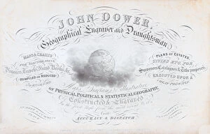
Trade card for John Dower, geographical engraver and draughtsman, 19th century
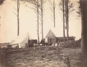
Copying Maps, Photographic Headquarters, Petersburg, Virginia, March 1865
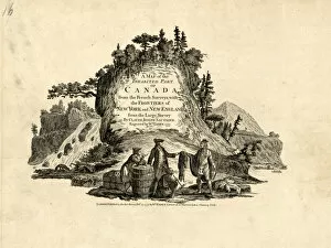
Indians in the Fur Trade in Canada, 1777. Creator: Faden, William (1749-1836)Indians in the Fur Trade in Canada. From: " A map of the Inhabited Part of Canada from the French Surveys", 1777. Private Collection
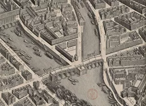
Pont Neuf. Plan de Paris, dit Turgot, 1739. Creator: AnonymousPont Neuf. Plan de Paris, dit Turgot, 1739. Found in the Collection of Bibliotheque Nationale de France
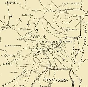
Matabeleland, 1900. Creator: UnknownMatabeleland, 1900. From " South Africa and the Transvaal War, Vol. I", by Louis Creswicke. [T. C. & E. C. Jack, Edinburgh, 1900]
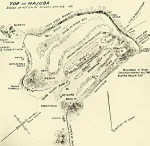
Top of Majuba - Scene of Action of Sunday 27th Feb 1881, 1900. Creator: UnknownTop of Majuba - Scene of Action of Sunday 27th Feb 1881, 1900. From " South Africa and the Transvaal War, Vol. I", by Louis Creswicke. [T. C. & E. C. Jack, Edinburgh, 1900]
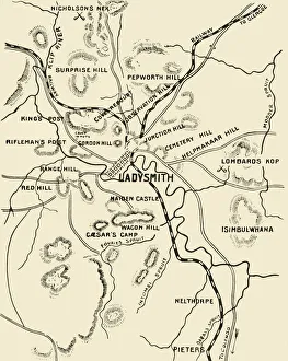
Map of Ladysmith and Surrounding Heights, 1900. Creator: UnknownMap of Ladysmith and Surrounding Heights, 1900. From " South Africa and the Transvaal War, Vol. II", by Louis Creswicke. [T. C. & E. C. Jack, Edinburgh, 1900]
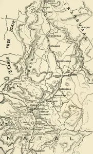
Map of Northern Natal. Scale 15 Statute Miles to the Inch, 1900. Creator: UnknownMap of Northern Natal. Scale 15 Statute Miles to the Inch, 1900. From " South Africa and the Transvaal War, Vol. II", by Louis Creswicke. [T. C. & E. C. Jack, Edinburgh, 1900]
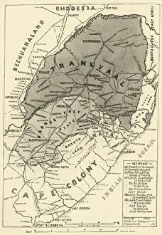
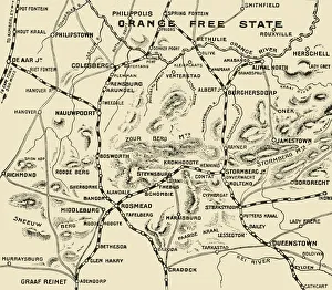
Map of the Boer Republics, 1900. Creator: UnknownMap of the Boer Republics, 1900. From " South Africa and the Transvaal War, Vol. I", by Louis Creswicke. [T. C. & E. C. Jack, Edinburgh, 1900]
Map Illustrating the Operations on the South of the Orange River, 1900. Creator: UnknownMap Illustrating the Operations on the South of the Orange River, 1900. From " South Africa and the Transvaal War, Vol. II", by Louis Creswicke. [T. C. & E. C. Jack, Edinburgh, 1900]
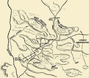
Plan of battle of Elandslaagte, 1900. Creator: UnknownPlan of battle of Elandslaagte, 1900. From " South Africa and the Transvaal War, Vol. II", by Louis Creswicke. [T. C. & E. C. Jack, Edinburgh, 1900]
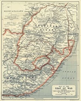
Map of the Seat of War, 1900. Creator: UnknownMap of the Seat of War, 1900. From " South Africa and the Transvaal War, Vol. II", by Louis Creswicke. [T. C. & E. C. Jack, Edinburgh, 1900]
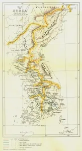
Map of Korea, 1903. Creator: UnknownMap of Korea, 1903. The Korean Empire proclaimed in October 1897 by Emperor Gojong of the Joseon dynasty stood until Japans annexation of Korea in August 1910
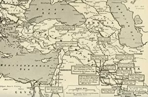
Map of Two and a Half Years Campaign in Mesopotamia, 1917. Creator: UnknownMap of Two and a Half Years Campaign in Mesopotamia, 1917. From " The War Illustrated Album De Luxe - Volume VIII. Ending The First Three Years", edited by J. A. Hammerton
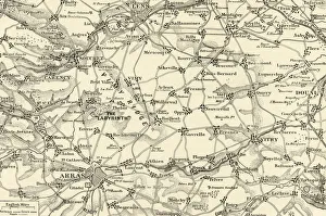
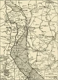
Detailed Map of the Arras Fighting Area, 1917. Creator: UnknownDetailed Map of the Arras Fighting Area, 1917. From " The War Illustrated Album De Luxe - Volume VIII. Ending The First Three Years", edited by J. A. Hammerton
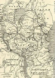
The Campaign in German East Africa, 1917. Creator: UnknownThe Campaign in German East Africa, 1917. From " The War Illustrated Album De Luxe - Volume VIII. Ending The First Three Years", edited by J. A. Hammerton
The Great Arras Battle Area, 1917. Creator: UnknownThe Great Arras Battle Area, 1917. From " The War Illustrated Album De Luxe - Volume VIII. Ending The First Three Years", edited by J. A. Hammerton
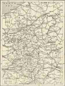
Map Showing German Retreat in the West, 1917, 1917. Creator: UnknownMap Showing German Retreat in the West, 1917, 1917. From " The War Illustrated Album De Luxe - Volume VIII. Ending The First Three Years", edited by J. A. Hammerton
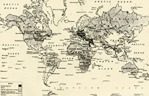
Map of the World After Three Years of War, 1917. Creator: UnknownMap of the World After Three Years of War, 1917.From " The War Illustrated Album De Luxe - Volume VIII. Ending The First Three Years", edited by J. A. Hammerton
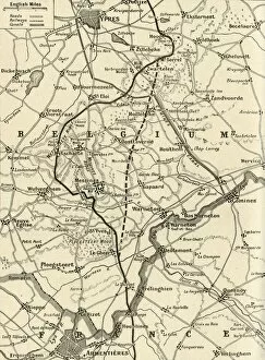
The Battle of Messines, 1917. Creator: UnknownThe Battle of Messines, 1917. From " The War Illustrated Album De Luxe - Volume VIII. Ending The First Three Years", edited by J. A. Hammerton. [The Amalgamated Press, Limited, London, 1917]
The Globes (From the Grand Atlas of all the World), 1725. Creator: Homann, Johann BaptistThe Globes (From the Grand Atlas of all the World), 1725. Private Collection
General map of Estonia and Latvia. (Atlas de la Livonie), 1798. Private Collection
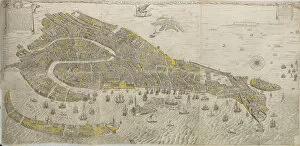
Vero e real disegno della inclita cita di Venetia. (Panorama of Venice), 1676. Creator: ScolariVero e real disegno della inclita cita di Venetia. (Panorama of Venice), 1676. Private Collection
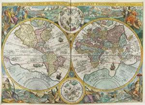
Itinerarium. World map with costumes, natives, ships, plants and animals, 1644. CreatorItinerarium. World map with costumes, natives, ships, plants and animals, 1644. Private Collection
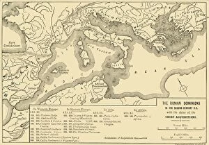
The Roman Dominions in the Second Century B. C. with the dates of the Chief Acquistions, 1890The Roman Dominions in the Second Century B.C. with the dates of the Chief Acquistions, 1890. From " Cassells Illustrated Universal History Vol. II - Rome", by Edmund Ollier
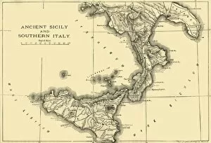
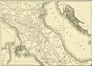
Ancient Sicily and Southern Italy, 1890. Creator: UnknownAncient Sicily and Southern Italy, 1890. From " Cassells Illustrated Universal History Vol. II - Rome", by Edmund Ollier. [Cassell and Company, Limited, London, Paris and Melbourne, 1890]
Map of Northern and Central Italy, 1890. Creator: UnknownMap of Northern and Central Italy, 1890. From " Cassells Illustrated Universal History Vol. II - Rome", by Edmund Ollier. [Cassell and Company, Limited, London, Paris and Melbourne, 1890]
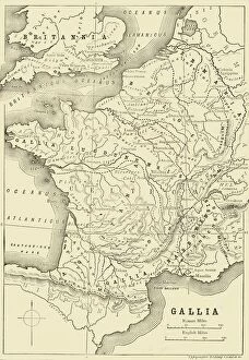
Map of Gaul and Part of Britain, 1890. Creator: UnknownMap of Gaul and Part of Britain, 1890. From " Cassells Illustrated Universal History Vol. II - Rome", by Edmund Ollier. [Cassell and Company, Limited, London, Paris and Melbourne, 1890]
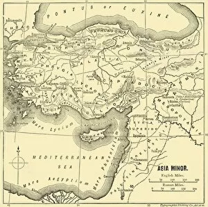
Asia Minor - Map, 1890. Creator: UnknownAsia Minor - Map, 1890. From " Cassells Illustrated Universal History Vol. II - Rome", by Edmund Ollier. [Cassell and Company, Limited, London, Paris and Melbourne, 1890]
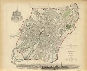
Plan of Moscow, 1836. Creator: Davies, Benjamin Rees (1789-1872)Plan of Moscow, 1836. Private Collection
General Map of Kazan Governorate, 1779. Creator: Chernoi (Cherny), Fyodor Osipovich (1745-1790)General Map of Kazan Governorate, 1779. Private Collection
Plan of Moscow, 1916. Creator: Ilyin, Alexei Alexeevich (1858-1942)Plan of Moscow, 1916. Private Collection
Map of the Black Sea including part of present-day Romania, Bulgaria, Turkey, Ukraine, and Russia, c. 1544. Private Collection
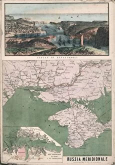
Map of southern Russia with view of Sevastopol Bay and its fortifications, 1853. Creator: CivelliMap of southern Russia with view of Sevastopol Bay and its fortifications, 1853. Private Collection
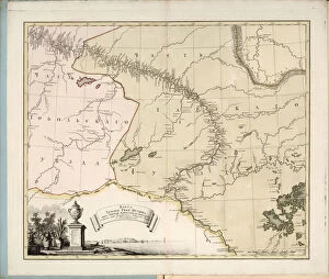
Map of the flow of the Irtysh River from Omsk fortress into Tobolsk, 1780. Creator: IslenyevMap of the flow of the Irtysh River from Omsk fortress into Tobolsk, 1780. Private Collection
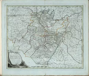
General Map of Nizhny Novgorod Governorate, 1788. Creator: Chernoi (Cherny), Fyodor OsipovichGeneral Map of Nizhny Novgorod Governorate, 1788. Private Collection
Panoramic view of Kronstadt, 1853. Creator: Civelli, Giuseppe (1816-1882)Panoramic view of Kronstadt, 1853. Private Collection
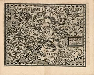
Moscoviae Imperium, 1600. Creator: Quad, Matthias (1557-1613)Moscoviae Imperium, 1600. Private Collection
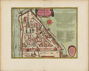
The Moscow Kremlin Map of the 16th century (Castellum Urbis Moskvae), ca. 1600. Creator: BlaeuThe Moscow Kremlin Map of the 16th century (Castellum Urbis Moskvae), ca. 1600. Private Collection
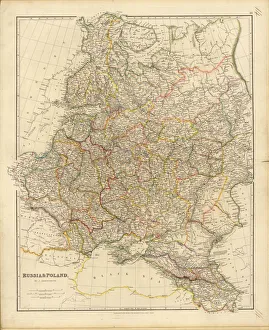
Map of Russia and Poland, 1832. Creator: Arrowsmith, John (1790-1873)Map of Russia and Poland, 1832. Private Collection
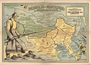
Mongolia and Manchukuo, 1936. Creator: Hix, John (1907-1944)Mongolia and Manchukuo, 1936. Private Collection