mail_outline sales@mediastorehouse.com
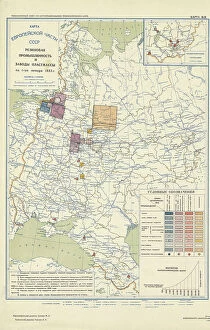
Automotive and tractor manufacturing on January 1, 1933, 1934. Creator: Mikhail Alekseevich TSvetkovAutomotive and tractor manufacturing on January 1, 1933, 1934. From the atlas "Industry of the USSR at the beginning of the 2nd Five-Year Plan
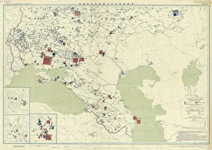
General mechanical engineering on January 1, 1933, 1934. Creator: Mikhail Alekseevich TSvetkovGeneral mechanical engineering on January 1, 1933, 1934. From the atlas "Industry of the USSR at the beginning of the 2nd Five-Year Plan
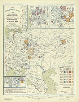
Power engineering and electrical industry as of January 1, 1933, 1934. Creator: Mikhail Alekseevich TSvetkovPower engineering and electrical industry as of January 1, 1933, 1934. From the atlas "Industry of the USSR at the beginning of the 2nd Five-Year Plan
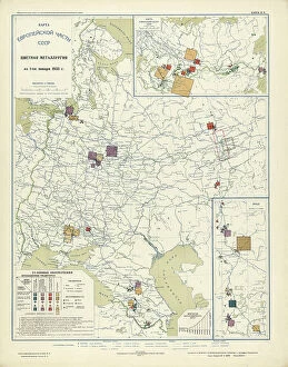
Non-ferrous metallurgy on January 1, 1933, 1934. Creator: Mikhail Alekseevich TSvetkovNon-ferrous metallurgy on January 1, 1933, 1934. From the atlas "Industry of the USSR at the beginning of the 2nd Five-Year Plan
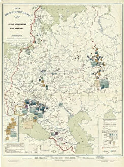
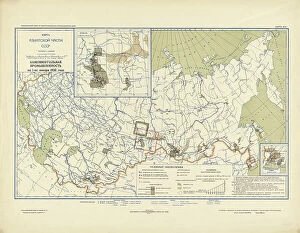
Ferrous metallurgy on January 1, 1933, 1934. Creator: Mikhail Alekseevich TSvetkovFerrous metallurgy on January 1, 1933, 1934. From the atlas "Industry of the USSR at the beginning of the 2nd Five-Year Plan
Peat industry on January 1, 1933, 1934. Creator: Mikhail Alekseevich TSvetkovPeat industry on January 1, 1933, 1934. From the atlas "Industry of the USSR at the beginning of the 2nd Five-Year Plan
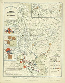
Oil industry on January 1, 1933, 1934. Creator: Mikhail Alekseevich TSvetkovOil industry on January 1, 1933, 1934. From the atlas "Industry of the USSR at the beginning of the 2nd Five-Year Plan
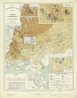
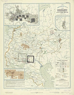
Coal industry on January 1, 1933, 1934. Creator: Mikhail Alekseevich TSvetkovCoal industry on January 1, 1933, 1934. From the atlas "Industry of the USSR at the beginning of the 2nd Five-Year Plan
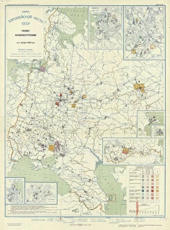
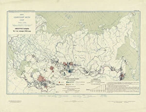
Power plants on January 1, 1933, 1934. Creator: Mikhail Alekseevich TSvetkovPower plants on January 1, 1933, 1934. From the atlas "Industry of the USSR at the beginning of the 2nd Five-Year Plan
Power Plants, 1934. Creator: Mikhail Alekseevich TSvetkovPower Plants, 1934. From the atlas "Industry of the USSR at the beginning of the 2nd Five-Year Plan. Geographical atlas." Conventional signs: borders (5 types), settlements (7 groups)
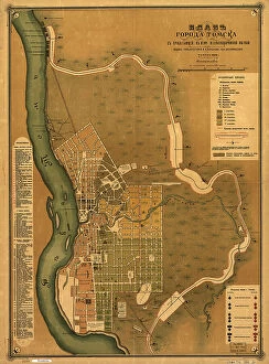
Plan goroda Tomskas prilegai?u?shchei? k nemu zheli?e?znodorozhnoi? vi?e?tv'i?u?, 1898. Creators: M. NPlan goroda Tomskas prilegai?u?shchei? k nemu zheli?e?znodorozhnoi? vi?e?tv'i?u?, 1898. Scale 1:16, 800; Relief shown by land form drawings. Russian. Shows wards and fire districts
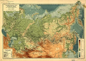
Gipsometricheskai?a? karta Rossi¯i?skoi? Imperi¯i : (opyt izobrazheni¯i?a? rel'efa Imperi¯i), (1912)Gipsometricheskai?a? karta Rossi¯i?skoi? Imperi¯i : (opyt izobrazheni¯i?a? rel'efa Imperi¯i), (1912?). Relief and depths shown by gradient tints. Also shows railroads. In Russian. Pulkovo (St)
Atlas of the Yakut ASSR (Autonomous Soviet Socialist Republic). Socialist Yakutia, 1982. Creator: Soviet UnionAtlas of the Yakut ASSR (Autonomous Soviet Socialist Republic). Socialist Yakutia, 1982. This atlas was published in 1982 for the commemoration of the 60th anniversary of the formation of the Soviet
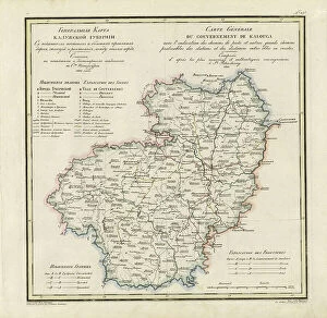
General Map of Kaluga Province: Showing Postal and Major Roads, Stations and... 1822General Map of Kaluga Province: Showing Postal and Major Roads, Stations and the Distance in Versts between Them, 1822. This 1822 map of Kaluga Province is from a larger work
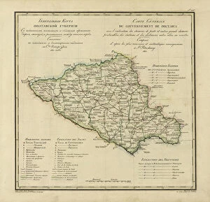
General Map of Poltava Province: Showing Postal and Major Roads, Stations and... 1821General Map of Poltava Province: Showing Postal and Major Roads, Stations and the Distance in Versts between Them, 1821. This 1821 map of Poltava Provinceis from a larger work
Map of Baikal, a Sea, a Lake, or an Angara Gap, Located in the Irkutsk Province... 1814. Creator: UnknownMap of Baikal, a Sea, a Lake, or an Angara Gap, Located in the Irkutsk Province with All the Neighboring [Territory], Whose Mathematical Measurements were Completed and it Became Fully Known in 1806
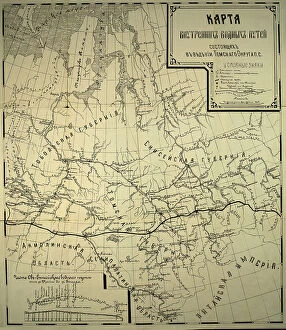
Map of inland waterways under the jurisdiction of the Tomsk district, 1800. Creator: UnknownMap of inland waterways under the jurisdiction of the Tomsk district, 1800
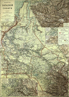
Map of Western Siberia, 1899-1914. Creator: Veniamin PetrovichMap of Western Siberia, 1899-1914
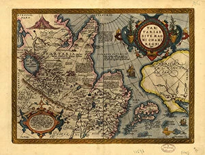
Tartariae sive Magni Chami Regni ty¨pus, 1603. Creators: Abraham Ortelius, Jan Baptist VrientsTartariae sive Magni Chami Regni ty¨pus, 1603. Covers northern Asia. Relief shown pictorially. From Abraham Ortelius's atlas: Theatrvm Orbis Terrarvm, 1603 ed. Hand col
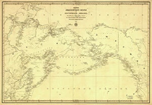
Karta Ledovitago mori?a? i Vostochnago okeana, 1844. Creator: UnknownKarta Ledovitago mori?a? i Vostochnago okeana, 1844. Depths shown by soundings in coastal waters. Also covers Russian Far East and Alaska
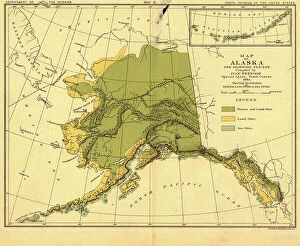
Map of Alaska and adjoining regions, 1882. Creator: Ivan PetrofMap of Alaska and adjoining regions, 1882. This multi-sheet map was produced by Ivan Petroff (also seen as Petroof and Petrof), a U.S
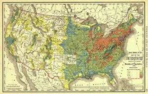
Rand, McNally & Co.'s map of the United States showing, in six degrees the density of pop... 1890Rand, McNally & Co.'s map of the United States showing, in six degrees the density of population, 1890, (1892). This map, published in 1892 by the Chicago-based Rand McNally and Company
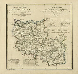
General Map of Pskov Province: Showing Postal and Major Roads, Stations and the Distance... 1820General Map of Pskov Province: Showing Postal and Major Roads, Stations and the Distance in Versts between Them, 1820. This 1820 map of Pskov Provinceis from a larger work
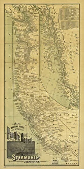
Map showing routes of the Pacific coast Steamship Company, 1891. Creator: Rand McNallyMap showing routes of the Pacific coast Steamship Company, 1891. This foldable tourist brochure, published by Rand McNally and Company in 1891
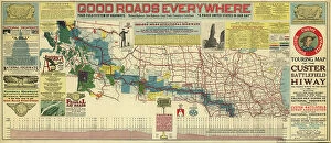
Touring map of the Custer Battlefield Hiway: the scenic route to the west, 1925. Creators: John C. Mulford, C. CTouring map of the Custer Battlefield Hiway: the scenic route to the west, 1925. The Custer Battlefield Highway was created in 1925 as a scenic route between Iowa and Montana
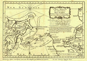
Carte re´duite des de´couvertes des Russes, entre l'Asie et l'Amerique, (1747?). This French map of Alaska, Siberia, and the North Pacific, published in 1747
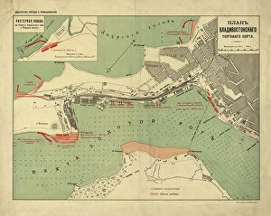
Plan Vladivostokskago torgovago porta, 1916. Creator: Ministerstvo torgovli i promyshlennostiPlan Vladivostokskago torgovago porta, 1916. Karta t?s?vetnai?a?, nakleena na tkan'. Dop. karta: Likhternai?a? gavan na beregu Amurskago zal. u Pervoi? rechki. M. [1:8 400]
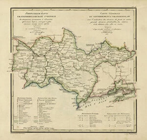
General Map of Ekaterinoslav Province: Showing Postal and Major Roads, Stations and the... 1821General Map of Ekaterinoslav Province: Showing Postal and Major Roads, Stations and the Distance in Versts between Them, 1821
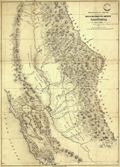
Topographical sketch of the gold & quicksilver district of California, 1848. Creator: Edward OrdTopographical sketch of the gold & quicksilver district of California, 1848. Published in July 1848 after the first gold strikes at Sutter's Mill on the American River in northern California
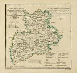
General Map of Chernigov Province: Showing Postal and Major Roads, Stations and... 1821General Map of Chernigov Province: Showing Postal and Major Roads, Stations and the Distance in Versts between Them, 1821
Millroy's map of Alaska and the Klondyke gold fields, 1897. Creator: J. J. MillroyMillroy's map of Alaska and the Klondyke gold fields, 1897. The Klondike Gold Rush of 1898 began in earnest within 18 months of a major gold strike on Bonanza Creek
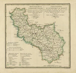
General Map of Kharkiv Province: Showing Postal and Major Roads, Stations and the... 1821General Map of Kharkiv Province: Showing Postal and Major Roads, Stations and the Distance in Versts between Them, 1821. This 1821 map of Kharkiv Provinceis from a larger work
Carte de Tartarie, 1706. Creator: Guillaume DelisleCarte de Tartarie, 1706
General Map of Vladimir Province: Showing Postal and Major Roads, Stations and the... 1822General Map of Vladimir Province: Showing Postal and Major Roads, Stations and the Distance in Versts between Them, 1822. This 1822 map of Vladimir Provinceis from a larger work
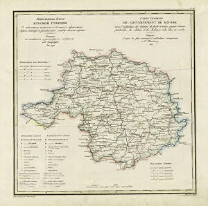
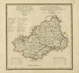
General Map of Kursk Province: Showing Postal and Major Roads, Stations and the... 1822General Map of Kursk Province: Showing Postal and Major Roads, Stations and the Distance in Versts between Them, 1822. This 1822 map of Kursk Provinceis from a larger work
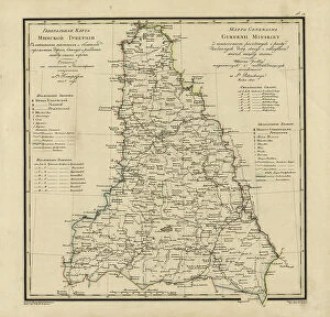
General Map of Moscow Province: Showing Postal and Major Roads, Stations and the.. 1821General Map of Moscow Province: Showing Postal and Major Roads, Stations and the Distance in Versts between Them, 1821. This 1821 map of Smolensk Provinceis from a larger work
General Map of Tver Province: Showing Postal and Major Roads, Stations and the... 1821General Map of Tver Province: Showing Postal and Major Roads, Stations and the Distance in Versts between Them, 1821. This 1821 map of Tver Provinceis from a larger work
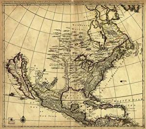
North America divided into its III principall [sic] parts, 1685. Creator: Philip LeaNorth America divided into its III principall [sic] parts, 1685. This map, North America Divided into its III Principal Parts
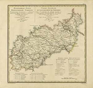
General Map of Novgorod Province: Showing Postal and Major Roads, Stations and the... 1821General Map of Novgorod Province: Showing Postal and Major Roads, Stations and the Distance in Versts between Them, 1821. This 1821 map of Novgorod Provinceis from a larger work
Map of the Alaskan gold fields, 1897. Creator: T. S. LeeMap of the Alaskan gold fields, 1897. Beginning in the mid-19th century, gold was discovered in a succession of strikes along the western coast of the United States in an ascending arc
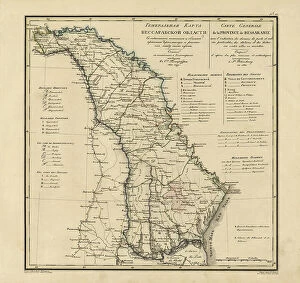
General Map of Bessarabia: Showing Postal and Major Roads, Stations and the... 1821General Map of Bessarabia: Showing Postal and Major Roads, Stations and the Distance in Versts between Them, 1821. This 1821 map of Bessarabia is from a larger work
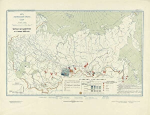
The Five-Year Plan of New Construction of Industry of the USSR: Map of the Asiatic Part... 1930 Creator: I. AThe Five-Year Plan of New Construction of Industry of the USSR: Map of the Asiatic Part of the USSR, 1930. Supplement to the map of the Five-Year plan of the European part of the USSR
General Map of Minsk Province: Showing Postal and Major Roads, Stations and the... 1821General Map of Minsk Province: Showing Postal and Major Roads, Stations and the Distance in Versts between Them, 1821. This 1821 map of Minsk Province is from a larger work
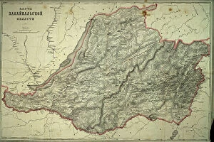
Map of Zabaikal'sk Province, Before 1914. Creator: A. IlinaMap of Zabaikal'sk Province, Before 1914
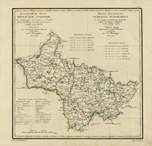
General Map of Vitebsk Province: Showing Postal and Major Roads, Stations and the... 1820General Map of Vitebsk Province: Showing Postal and Major Roads, Stations and the Distance in Versts between Them, 1820. This 1820 map of Vitebsk Provinceis from a larger work
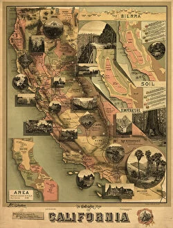
The unique map of California, 1888. Creator: E. McD. JohnstoneThe unique map of California, 1888. It was issued in 1888 by the Southern Pacific Railroad Company and the California State Board of Trade as part of a campaign to promote the economic, cultural