mail_outline sales@mediastorehouse.com
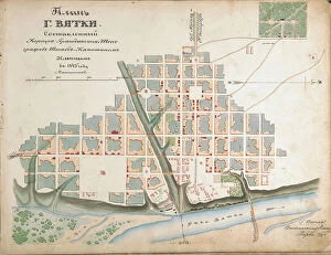
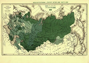
Plan of the city of Vyatka, 1843. Creator: Ilyin, Alexey Afinogenovich (1832-1889)Plan of the city of Vyatka, 1843. Private Collection
Map of the Holy Land Divided into the Twelve Tribes of Israel, 1580s. Creator: AdrichemMap of the Holy Land Divided into the Twelve Tribes of Israel, 1580s. Private Collection
Map of the Holy Land Divided into the Twelve Tribes of Israel, um 1700. Creator: Nolin, Jean-Baptiste (1657-1708)Map of the Holy Land Divided into the Twelve Tribes of Israel, um 1700. Private Collection
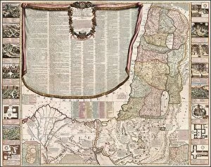
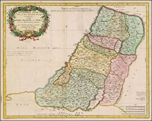
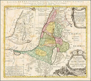
Map of the Holy Land Divided into the Twelve Tribes of Israel, c. 1710. Creator: Homann, Johann Baptist (1663-1724)Map of the Holy Land Divided into the Twelve Tribes of Israel, c. 1710. Private Collection
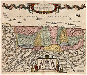
Map of the Holy Land Divided into the Twelve Tribes of Israel, 1679. Creator: Anonymous masterMap of the Holy Land Divided into the Twelve Tribes of Israel, 1679. Private Collection
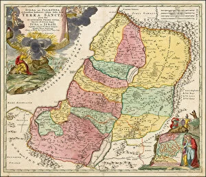
Map of the Holy Land Divided into the Twelve Tribes of Israel, 1670. Creator: Wit, Frederik de (1630-1706)Map of the Holy Land Divided into the Twelve Tribes of Israel, 1670. Private Collection
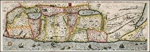
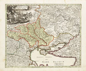
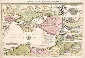
Map of Ukraine and surroundings of the Black Sea, um 1700. Creator: Weigel, Christoph, the Elder (1654-1725)Map of Ukraine and surroundings of the Black Sea, um 1700. Private Collection
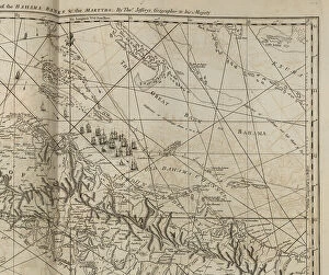
The part of the Bahama banks, from The West-India atlas, 1771. Creator: Jefferys, Thomas (ca. 1719-1771)The part of the Bahama banks, from The West-India atlas, 1771. Private Collection
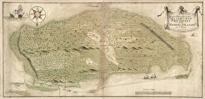
Map of the island of New Providence one of the Bahamas Islands in the West Indies, Mid 18th cenMap of the island of New Providence one of the Bahamas Islands in the West Indies, Mid of the 18th. Private Collection
Map of the Holy Land Divided into the Twelve Tribes of Israel, ca 1730. Creator: Homann, Johann Baptist (1663-1724)Map of the Holy Land Divided into the Twelve Tribes of Israel, ca 1730. Private Collection
A military map depicting Russo-Turkish War of 1735-1739, 1737. Creator: AnonymousA military map depicting Russo-Turkish War of 1735-1739, 1737. Private Collection
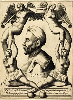
Portrait of Girolamo Ruscelli, 1566. Creator: Nicolo NelliPortrait of Girolamo Ruscelli, 1566
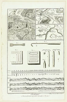
Topographic, Geographic and Music Engraving, from Encyclopédie, 1762/77. Creators: A. J. Defehrt, Madame de LusseTopographic, Geographic and Music Engraving, from Encyclopedie, 1762/77
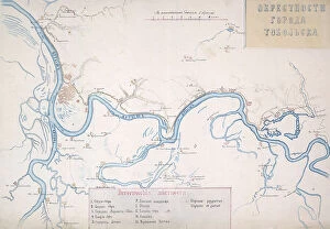
Map of the Irtysh region from the village of Zashchitina to the Epanchinsky yurts... 1880. Creator: Mikhail ZnamenskyMap of the Irtysh region from the village of Zashchitina to the Epanchinsky yurts, 1880. The third page of the album "Walks through the historical environs of the city of Tobolsk.", 1880
Map of the Nerchinsk Region from the Office of His Majesty, 1914. CreatorMap of the Nerchinsk Region from the Office of His Majesty, 1914. From the atlas "Atlas of Asian Russia."
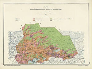
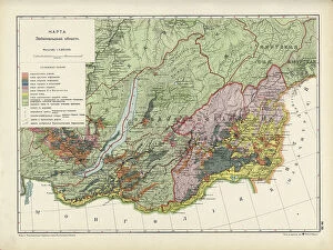
Map on the drainage of the Barabinsk steppe in the Tomsk province, Kainsk district, 1914. From the atlas "Atlas of Asian Russia."
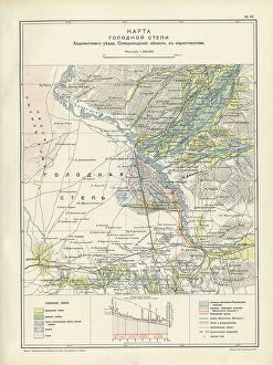
Map of the barren steppe of the Khodzhentsk distric, Samarkand region, with its environs, 1914. From the atlas "Atlas of Asian Russia."
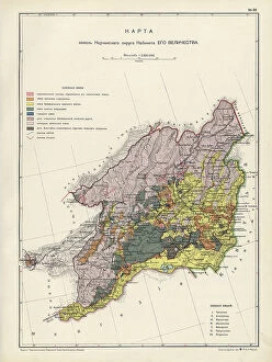
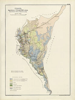
Plan Murgabskogo Gosudareva imeniia, Zakaspiiskoi oblasti, Mervskogo uezda, 1914. From the atlas "Atlas of Asian Russia."
Map of the Altai Region from the Office of His Majesty, 1914. Creator: Resettlement Department of the Land RegulationMap of the Altai Region from the Office of His Majesty, 1914. From the atlas "Atlas of Asian Russia."
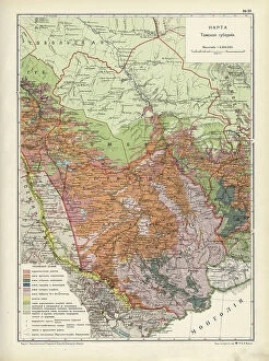
Map of Zabaikal Province, 1914. Creator: Resettlement Department of the Land Regulation and Agriculture AdministrationMap of Zabaikal Province, 1914. From the atlas "Atlas of Asian Russia."
Map of Enisei Province, 1914. Creator: Resettlement Department of the Land Regulation and Agriculture AdministrationMap of Enisei Province, 1914. From the atlas "Atlas of Asian Russia."
Map of Irkutsk Province, 1914. Creator: Resettlement Department of the Land Regulation and Agriculture AdministrationMap of Irkutsk Province, 1914. From the atlas "Atlas of Asian Russia."
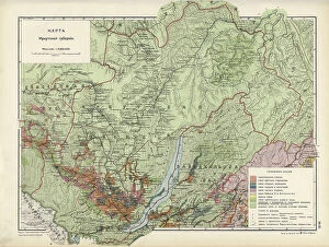
Map of Tomsk Province, 1914. Creator: Resettlement Department of the Land Regulation and Agriculture AdministrationMap of Tomsk Province, 1914. From the atlas "Atlas of Asian Russia."
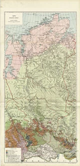
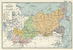
Map of the Military Districts of Asiatic Russia, 1914. Creator: Resettlement Department of the Land RegulationMap of the Military Districts of Asiatic Russia, 1914. From the atlas "Atlas of Asian Russia."
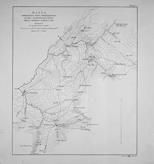
Map of exploration work carried out in 1895 in the Mariinsky District. Ubienka.. 1895. Creator: UnknownMap of exploration work carried out in 1895 in the Mariinsky District. Ubienka, B. Barandat, lake; Pike and so on, 1895
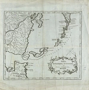
Map of the Kuril Islands with Surrounding Areas, 1700-1799. Creator: UnknownMap of the Kuril Islands with Surrounding Areas, 1700-1799. This 18th century Russian map depicts the Kurile Islands archipelago, located on the far eastern edge of the Russian Empire
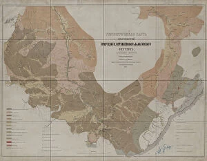
Geognostic Map of the Localities of Irkutsk, Verkholensk, and Balagansk Districts, 1873. The first geological (geognostic) maps in Russia were produced in the 1850s
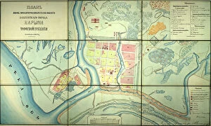
Plan of the newly designed location of the provincial town of Narym, Tomsk province, 1868. Creator: UnknownPlan of the newly designed location of the provincial town of Narym, Tomsk province, 1868
Projecting Plan of a District City Tomsk, Made in 1872, 1873. Creator: UnknownProjecting Plan of a District City Tomsk, Made in 1872, 1873
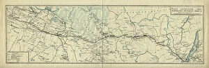
Map of the Route of the Siberian Railway Line, 1891-1916.. Creator: UnknownMap of the Route of the Siberian Railway Line, 1891-1916
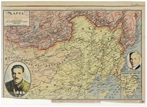
Map of the Far East of the USSR, Northern China (Manchuria) and Mongolia, 1930. Creator: UnknownMap of the Far East of the USSR, Northern China (Manchuria) and Mongolia, 1930. This Soviet-era map is intended to serve a propaganda purpose
Karta I?A?kutskoi? oblasti chasti Olekminskago okruga i Irkutskoi? guberni¯i? Kirenskogo... 1853. Creator: UnknownKarta I?A?kutskoi? oblasti chasti Olekminskago okruga i Irkutskoi? guberni¯i? Kirenskogo [sic] chast okrugas pokazani¯em zolotosoderzhashchikh pri¯i?skov razrabatyvaemyi?a? : gg
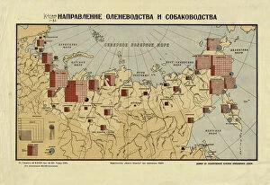
The direction of reindeer husbandry and dog breeding, 1932. Creator: UnknownThe direction of reindeer husbandry and dog breeding, 1932. Conventional signs: adult reindeer with the distinction of sled dogs, adult dogs with the distinction of sled dogs, herding dogs
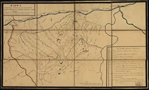
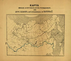
[Karty pochtovykh soobshcheni¯i? uchrezhdennykh v Rossi¯i?skoi? Imperi¯i pri T?S?ari?e... (186-?). Creator: Unknown[Karty pochtovykh soobshcheni¯i? uchrezhdennykh v Rossi¯i?skoi? Imperi¯i pri T?S?ari?e? Aleksi?e?i?e? Mikhailovichi?e? i ego preemnikakh do Ekateriny II], (186-?)
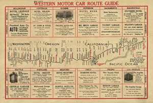
Western motor car route guide, (1915?). Creator: UnknownWestern motor car route guide, (1915?). This automobile guide shows the main highway route between Vancouver, Canada, and San Diego, California, circa 1915
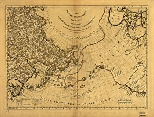
The Russian discoveries from the map published by the Imperial Academy of St. Petersburg, 1775. Creator: UnknownThe Russian discoveries from the map published by the Imperial Academy of St. Petersburg, 1775. This map, showing the known geography of Alaska in the late 18th century
Kartogramma "grippa" : [Russia], 1890. Creator: Unknown. Kartogramma "grippa" : [Russia], 1890Kartogramma "grippa" : [Russia], 1890. Shows occurrence of influenza by province. Each map has a number at head of title, and a month or months at the end of the title: No. 50
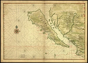
Map of California shown as an island, c 1650. Creator: Johannes VingboonsMap of California shown as an island, c 1650. This map from around 1650 shows California as an island. A half-century would pass before Spanish explorers determined with certainty that California was
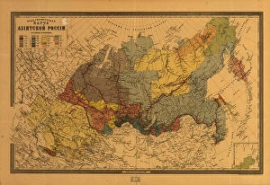
E?tnograficheskai?a? karta Azi¯i?a?tskoi? Rossi¯i, (187-?). Creator: Mikhail VeniukovE?tnograficheskai?a? karta Azi¯i?a?tskoi? Rossi¯i, (187-?). Pulkovo meridian
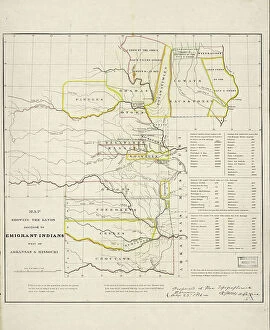
Map showing the lands assigned to emigrant Indians west of Arkansas and Missouri, 1836. Creator: Topographical BureauMap showing the lands assigned to emigrant Indians west of Arkansas and Missouri, 1836. Following passage of the Indian Removal Act in 1830
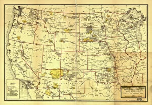
Indian Reservations west of the Mississippi River, 1923. Creator: Office of Indian AffairsIndian Reservations west of the Mississippi River, 1923. This map, created by the Office of Indian Affairs in 1923, shows the location of Indian reservations west of the Mississippi River
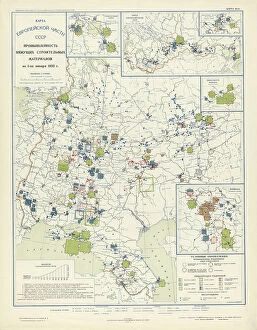
Industry of binding building materials on January 1, 1933, 1934. Creator: Mikhail Alekseevich TSvetkovIndustry of binding building materials on January 1, 1933, 1934. From the atlas "Industry of the USSR at the beginning of the 2nd Five-Year Plan
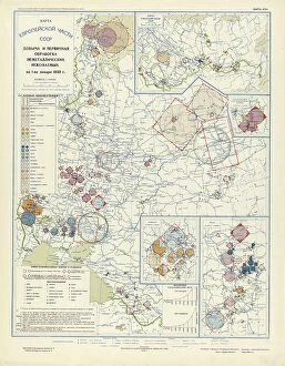
Extraction and primary processing of non-metallic minerals as of January 1, 1933, 1934. From the atlas "Industry of the USSR at the beginning of the 2nd Five-Year Plan
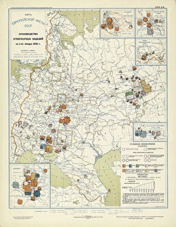
Production of refractory products on January 1, 1933, 1934. Creator: Mikhail Alekseevich TSvetkovProduction of refractory products on January 1, 1933, 1934. From the atlas "Industry of the USSR at the beginning of the 2nd Five-Year Plan
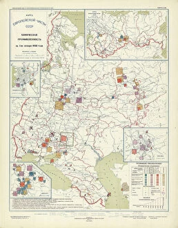
Chemical industry of the USSR on January 1, 1933, 1934. Creator: Mikhail Alekseevich TSvetkovChemical industry of the USSR on January 1, 1933, 1934. From the atlas "Industry of the USSR at the beginning of the 2nd Five-Year Plan
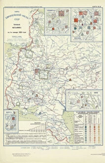
Precision mechanics on January 1, 1933, 1934. Creator: Mikhail Alekseevich TSvetkovPrecision mechanics on January 1, 1933, 1934. From the atlas "Industry of the USSR at the beginning of the 2nd Five-Year Plan
Agricultural engineering as of January 1, 1933, 1934. Creator: Mikhail Alekseevich TSvetkovAgricultural engineering as of January 1, 1933, 1934. From the atlas "Industry of the USSR at the beginning of the 2nd Five-Year Plan