mail_outline sales@mediastorehouse.com
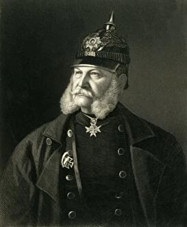
William I, King of Prussia & Emperor of Germany, c1872. Creator: William HollWilliam I, King of Prussia & Emperor of Germany, c1872. Portrait of Wilhelm (1797-1888) who became King of Prussia in 1861 and was proclaimed Emperor of Germany in 1871 after the Franco-Prussian War
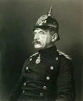
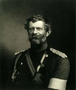
Von Roon, c1872. Creator: William HollVon Roon, c1872. Portrait of Albrecht Theodor Graf Emil von Roon (1803-1879), Prussian soldier and politician who was Minister of War from 1859 to 1873
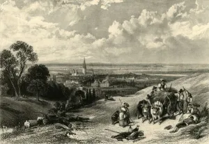
Bonn, c1872. Creator: Thomas Abiel PriorBonn, c1872. Farming scene in the German countryside, with the city of Bonn and Bonn Minster in the distance. From " The Franco-Prussian War: its causes, incidents and consequences"
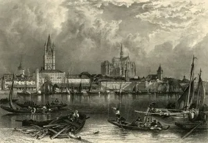
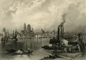
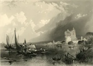
Cologne, c1872. Creator: E I RobertsCologne, c1872. Boats on the River Rhine at Cologne in northern Germany, with Great St Martin Church and Cologne Cathedral on the far bank
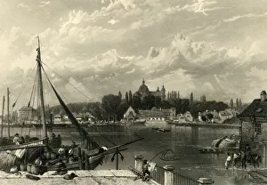
Mayence, c1872. Creator: E I RobertsMayence, c1872. View of sailing boats and steamships on the River Rhine in the city of Mainz, Germany. On the far bank is St Martins Cathedral
Bacharach, c1872. Creator: Thomas Abiel PriorBacharach, c1872. Boats on the River Rhine in the Rhine Gorge, Germany. On the far shore is the town of Bacharach am Rhein
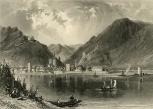
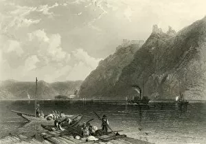
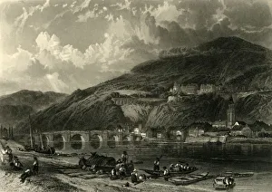
Ehrenbreitstein, c1872. Creator: E I RobertsEhrenbreitstein, c1872. View of the fortress at Ehrenbreitstein in Germany, at the junction of the Mosel and Rhine rivers
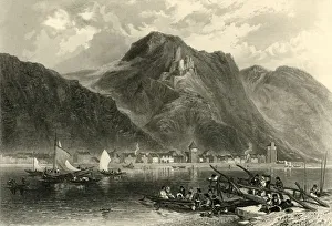
St. Goarhausen, c1872. Creator: Samuel BradshawSt. Goarhausen, c1872. Boats on the River Rhine at Sankt Goarshausen in the Rhine Gorge, Germany. The ruined Katz Castle can be seen above the town
Elfeldt, c1872. Creator: E I RobertsElfeldt, c1872. View of boats on the River Rhine at Eltville am Rhein in Germany. On the right is the Electoral Castle, with a lift net in the foreground
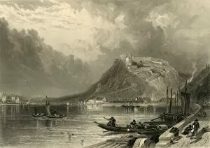
Liebenstein-Sternenfels, c1872. Creator: E I RobertsLiebenstein-Sternenfels, c1872. Boats on the River Rhine in Germany. On the cliffs above is Liebenstein Castle. From " The Franco-Prussian War: its causes, incidents and consequences"
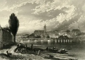
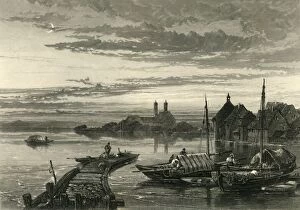
Mannheim, c1872. Creator: E I RobertsMannheim, c1872. View of the town of Mannheim, which sits at the confluence of the Rhine and the Neckar in Germany. A cargo ship is moored at the quayside
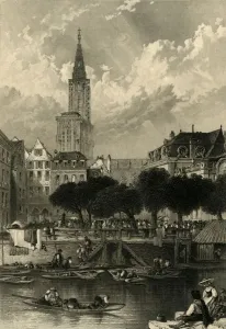
Strasburg, c1872. Creator: A WillmoreStrasburg, c1872. View of Strasbourg Cathedral and the River Ill. The city of Strasbourg was captured by the Prussians during the Franco-Prussian War of 1870-1871
Heidelberg, c1872. Creator: E I RobertsHeidelberg, c1872. View of the town of Heidelberg in Germany, with boats in the foreground, and the Old Bridge over the River Neckar beyond
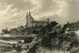
Speier, c1872. Creator: W. H. CaponSpeier, c1872. View of the town of Speyer in Germany. In the foreground is a bridge over a tributary of the River Rhine, with Speyer Cathedral, which dates from the 11th century, beyond
Basle, c1872. Creator: E I RobertsBasle, c1872. View of the city of Basel in Switzerland. In the centre is the Middle Bridge over the River Rhine, with Basel Minster beyond
Freiburg, c1872. Creator: A WillmoreFreiburg, c1872. View of a ford on the Dreisam river and the city of Freiburg im Breisgau, Germany. From " The Franco-Prussian War: its causes, incidents and consequences", Volume II
Laufenburg, c1872. Creator: E I RobertsLaufenburg, c1872. View of the town of Laufenburg, Switzerland, with a covered bridge over the River Rhine on the left, and the parish church tower and ruined castle on the right
Eglisau, c1872. Creator: Samuel BradshawEglisau, c1872. View of the town of Eglisau in Switzerland, with the covered bridge over the River Rhine. From " The Franco-Prussian War: its causes, incidents and consequences", Volume II
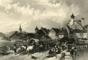
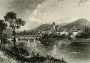
Schaffhausen, c1872. Creator: E I RobertsSchaffhausen, c1872. View of the town of Schaffhausen in Switzerland, showing the bridge over the High Rhine and the Munot, a 16th century fortress
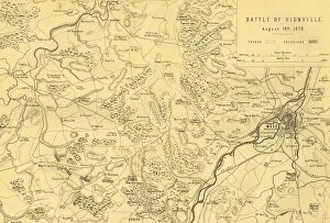
Map of the Battle of Vionville, 16 August 1870, (c1872). Creator: R. WalkerMap of the Battle of Vionville, 16 August 1870, (c1872). Map: Drawn under the Superintendance of Captain Hozier, showing the enemy positions
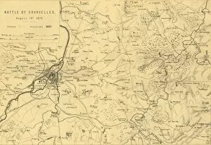
Map of the Battle of Courcelles, 14 August 1870, (c1872). Creator: R. WalkerMap of the Battle of Courcelles, 14 August 1870, (c1872). Map: Drawn under the Superintendance of Captain Hozier, showing the enemy positions
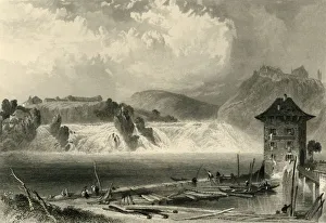
Rhine Falls, Schaffhausen, c1872. Creator: A WillmoreRhine Falls, Schaffhausen, c1872. View of Europes largest waterfall on the High Rhine, near the town of Schaffhausen in Switzerland
Rheinfelden, c1872. Creator: E I RobertsRheinfelden, c1872. View of the town of Rheinfelden, Switzerland, with the covered bridge over the High Rhine and the parish church
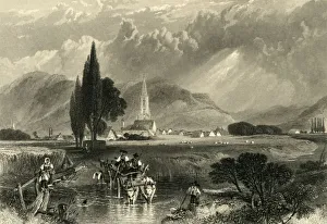
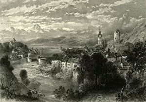
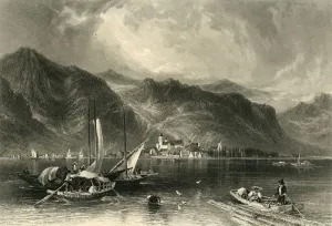
Bregenz, c1872. Creator: E I RobertsBregenz, c1872. View of the town of Bregenz on the eastern shores of Lake Constance, Austria, with boats in the foreground
Friedrichshafen, c1872. Creator: Edward Paxman BrandardFriedrichshafen, c1872. Boats on Lake Constance at Friedrichshafen in southern Germany. From " The Franco-Prussian War: its causes, incidents and consequences", Volume II
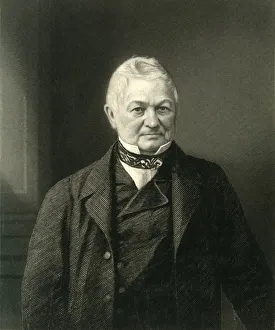
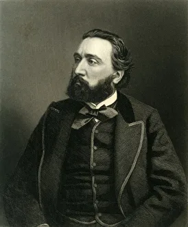
Thiers, c1872. Creator: William HollThiers, c1872. Portrait of French statesman and historian Louis Adolphe Thiers(1797-1877), the first President of the French Third Republic
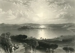
Lake of Constanz, c1872. Creator: A WillmoreLake of Constanz, and the islands of Mainau and Reichenau, c1872. View of Lake Constance through which the Rhine flows, situated where Germany, Switzerland, and Austria meet
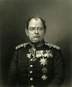
General Von Werder, c1872. Creator: CookGeneral Von Werder, c1872. Portrait of Prussian general Karl Wilhelm Friedrich August Leopold Graf von Werder (1808-1887)
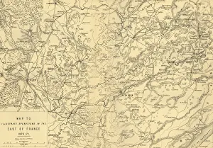
Map to Illustrate Operations in the East of France 1870-71, c1872. Creator: R. WalkerMap to Illustrate Operations in the East of France 1870-71, (c1872). Map: Drawn under the Superintendence of Captain Hozier, showing the towns of Dijon and Besancon
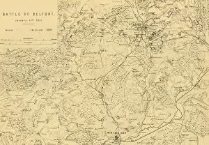
Map of the Battle of Belfort, 15 January 1871, (c1872). Creator: R. WalkerMap of the Battle of Belfort, 15 January 1871, (c1872). Map: Drawn under the Superintendence of Captain Hozier, showing the enemy positions
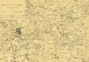
Map of the Battle of Le Mans, 11 January 1871, (c1872). Creator: R. WalkerMap of the Battle of Le Mans, 11 January 1871, (c1872). Map: Drawn under the Superintendence of Captain Hozier, showing the enemy positions
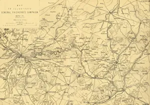
Map to Illustrate General Faidherbes Campaign 1870-71, c1872. Creator: R. WalkerMap to Illustrate General Faidherbes Campaign 1870-71, (c1872). Map of northern France: Drawn under the Superintendance of Captain Hozier, showing the towns of Amiens, Cambrai, St Quentin and Laon
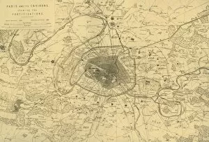
Paris and its Environs, showing the Fortifications, (c1872). Creator: R. WalkerParis and its Environs, showing the Fortifications, (c1872). Map: Drawn under the Superintendence of Captain Hozier, showing French and Prussian batteries (artillery positions)
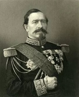
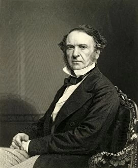
Manteuffel, c1872. Creator: H. CrickmoreManteuffel, c1872. Portrait of Edwin Freiherr von Manteuffel (1809-1885), German military commander noted for his victories in the Franco-Prussian War
General Bourbaki, c1872. Creator: UnknownGeneral Bourbaki, c1872. Portrait of French general Charles Denis Sauter Bourbaki (1816-1897). From " The Franco-Prussian War: its causes, incidents and consequences", Volume II
Gambetta, c1872. Creator: William HollGambetta, c1872. Portrait of French politician Leon Gambetta (1838-1882), an opponent of the French Second Empire. In 1870 he proclaimed the Third Republic after Napoleon III was captured by
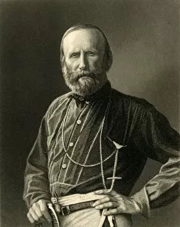
Garibaldi, c1872. Creator: William HollGaribaldi, c1872. Portrait of Italian general, politician and nationalist Guiseppe Garibaldi (1807-1882). Leading his 1, 000 Red Shirts, Garibaldi conquered Sicily and Naples
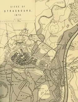
Map of the Siege of Strasbourg, 1870, (c1872). Creator: R. WalkerMap of the Siege of Strasbourg, 1870, (c1872). Drawn under the Superintendence of Captain Hozier. The city of Strasbourg (in France) underwent bombardment from Prussian general August von Werder
The Rt. Hon. William Ewart Gladstone, M. P. c1872. Creator: William HollThe Rt. Hon. William Ewart Gladstone, M.P. c1872. Portrait of British Liberal politician William Ewart Gladstone (1809-1898) who served as Prime Minister four times
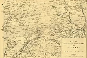
Map to Illustrate Operations by Orleans, (c1872). Creator: R. WalkerMap to Illustrate Operations by Orleans, (c1872). Map: Drawn under the Superintendence of Captain Hozier, showing the enemy positions
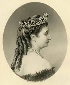
Eugenie, Empress Regent of France, c1872. Creator: Francis HollEugenie, Empress Regent of France, c1872. Portrait of Spanish-born Empress Eugenie (1826-1920). She became Empress Consort after she married Emperor Napoleon III of France in 1853
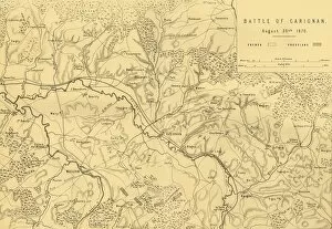
Map of the Battle of Carignan, 30 August 1870, (c1872). Creator: R. WalkerMap of the Battle of Carignan, 30 August 1870, (c1872). Map: Drawn under the Superintendence of Captain Hozier, showing the enemy positions
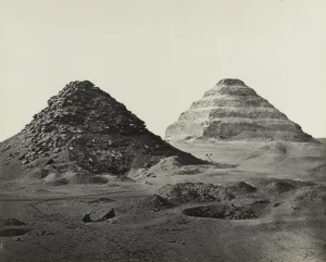
The Pyramids of Saqqara, from the Northeast, 1858. Creator: Francis Frith (BritishThe Pyramids of Saqqara, from the Northeast, 1858. Frith was the first photographer in Egypt to successfully use the wet collodion process, introduced in 1851
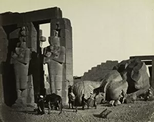
Fallen Statue at the Ramesseum, Thebes, 1857. This mammoth print conveys the epic scale of the memorial temple of Ramesses the Great while disclosing its smallest details
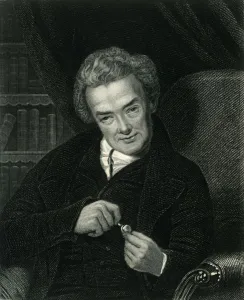
William Wilberforce, c1800, (c1884). Creator: UnknownWilliam Wilberforce, c1800, (c1884). William Wilberforce (1759-1833), British politician and philanthropist educated at Hull Grammar School and St Johns College, Cambridge
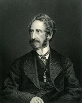
Edward G. E. L. Bulwer-Lytton, Lord Lytton, (1850), c1884. Creator: UnknownEdward G.E.L. Bulwer-Lytton, Lord Lytton, (1850), c1884. Edward Bulwer-Lytton (1803 -1873), English writer and politician educated at Trinity College, Cambridge
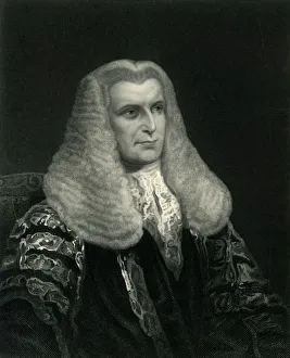
Lord Lyndhurst, c1830, (c1884). Creator: UnknownLord Lyndhurst, c1830, (c1884). John Copley, 1st Baron Lyndhurst (1772-1863), British lawyer and politician educated at a private school and Trinity College, Cambridge
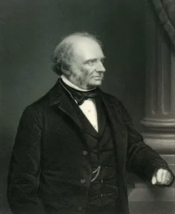
Earl Russell, c1860, (c1884). Creator: UnknownEarl Russell, c1860, (c1884). John Russell, 1st Earl Russell (1792-1878), Whig and Liberal politician, educated at Westminster School and Edinburgh University