mail_outline sales@mediastorehouse.com
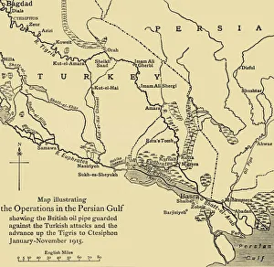
British oil pipeline in the Middle East, First World War, 1915, (c1920). Creator: UnknownBritish oil pipeline in the Middle East, First World War, 1915, (c1920). Map illustrating the Operations in the Persian Gulf; showing the British oil pipe guarded against the Turkish attacks
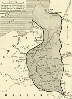
Land taken by Germany from Russia, First World War, 1915, (c1920). Creator: UnknownLand taken by Germany from Russia, First World War, 1915, (c1920). The Germanic Slice out of Russian Territory to the end of the Summer Campaign of 1915...territory gained by the Germans
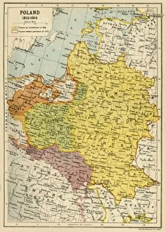
Poland, 1815-1914, (c1920). Creator: John Bartholomew & SonPoland, 1815-1914, (c1920). Map showing Polish territory from the end of the 18th century until the First World War: Poland as constituted in 1815, and Poland before partition of 1772
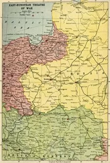
East-European Theatre of War, 1914-1918, (c1920). Creator: John Bartholomew & SonEast-European Theatre of War, 1914-1918, (c1920). Map of Eastern Europe during the First World War, showing parts of Germany, Russia and Austria-Hungary
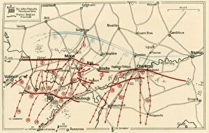
Sketch of the Chief Operations Near Mons and Charleroi, c1914, (c1920). Creator: UnknownSketch of the Chief Operations Near Mons and Charleroi, c1914, (c1920). British, French and German positions in northern France and Belgium at the start of the First World War
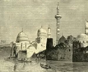
Mosul, Chief Town of Al-Jezireh (Mesopotamia), 1890. Creator: UnknownMosul, Chief Town of Al-Jezireh (Mesopotamia), 1890. Mosul city on the Tigris river in Iraq, in late 9th century was seized by Turkish dynasts
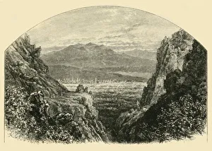
Approach to Antioch, 1890. Creator: UnknownApproach to Antioch, 1890. Ancient Greek city on the eastern side of the Orontes River, founded 4th century BC by Seleucus I Nicator
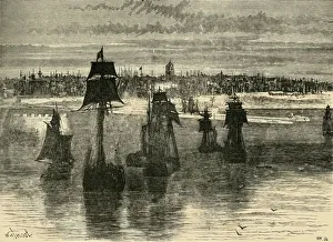
Dunkirk, 1890. Creator: UnknownDunkirk, 1890. Disputed territory between Spain, the Netherlands, England and France in 16th century, Dunkirk wassold to France by Charles II for £ 320, 000 in 1662
Napoleons troops during the war against Austria, October 1805, (1936). Creator: UnknownNapoleons troops during the war against Austria, October 1805, (1936). Die Truppen Napoleons I Uberschreiten Im Kriege Gegen Osterreich, Oktober 1805
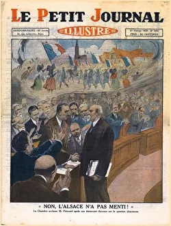
No, Alsace did not lie!, 1929. Creator: UnknownNo, Alsace did not lie!, 1929. Non, l Alsace n a Pas Menti!. Fellow politicians congratulate President of the French Republic Raymond Poincare after his moving speech on the Alsace question
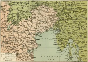
Map of the Italian Fighting Front, 1919. Creator: George Philip & Son LtdMap of the Italian Fighting Front, 1919. Map showing north-eastern Italy, the Trentino and part of southern Austria during the First World War, 1914-1919
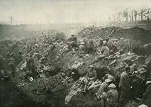
Consolidating A Captured Position, (1919). Creator: UnknownConsolidating A Captured Position, (1919). Scene from the First World War, 1914-1919, British soldiers in enemy trenches: Not the least important part of " consolidating" a captured
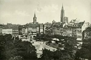
Strasburg, (1919). Creator: UnknownStrasburg, (1919). View of the city of Strasbourg which has at different periods in history been part of Germany and of France
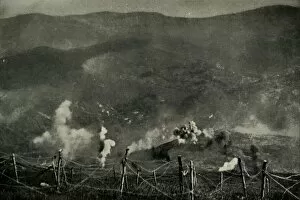
Fighting for the Lost Province of Alsace, (1919). Creator: UnknownFighting for the Lost Province of Alsace, (1919). Scene from the First World War, 1914-1919: The marvellous effect of the French artillery on the German lines on the Alsatian frontier...An artillery
Governor Stuyvesant Destroying The Summons To Surrender, (1877). Creator: UnknownGovernor Stuyvesant Destroying The Summons To Surrender, (1877). Dutch soldier and colonial administrator Peter Stuyvesant (c1612-1672)
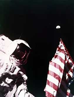
Harrison Schmitt with US flag on the surface of the Moon, Apollo 17 mission, December 1972Astronaut Harrison Schmitt with US flag on the surface of the Moon, Apollo 17 mission, December 1972. Earth can be seen floating above the flag
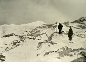
Taking Possession of Cape Bernacchi, Victoria Land, c1908, (1909). Anglo-Irish explorer Ernest Shackleton (1874-1922) made three expeditions to the Antarctic
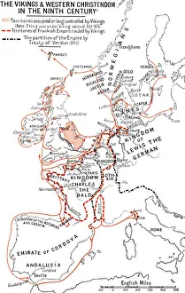
Map of the Vikings & Western Christendom in the Ninth Century, (1935). Modern map showing territories occupied, controlled or raided by the Vikings (roughly 793-1066 AD)
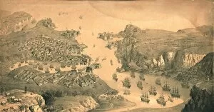
The town, forts and harbours of Sebastopol, 1854. Artist: Edmund WalkerThe town, forts and harbours of Sebastopol, 1854. View of Sevastopol, a major port and naval base on the Crimean Peninsula, looking towards the Black Sea
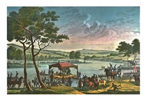
Meeting of the two Emperors, 25 June 1807, (c1850). Artist: Francois-Louis CouchéMeeting of the two Emperors, 25 June 1807, (c1850). Napoleon I meets Alexander I, Czar of Russia, on a raft in the middle of the river Niemen, near Tilsit (Russia)
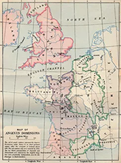
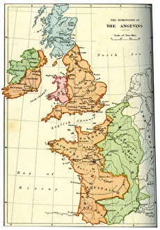
Map of Angevin Dominions, 1902. Artist: FS WellerMap of Angevin Dominions, 1902. From Social England, edited by H.D. Traill, D.C.L. and J. S. Mann, M.A. [Cassell and Company, Limited, London, Paris, New York & Melbourne, 1902]
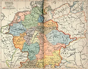
Germany about the Year 1000, c1906, (1907). Artist: Karl WolfGermany about the Year 1000, c1906, (1907). From The Worlds History, Volume VI. Edited by Dr. H. F. Helmolt [William Heinemann, London, 1907]
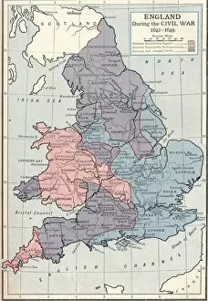
England during the Civil War, 1642-1649 (1905). From Cassells History of England, Vol. IV, [Cassell and Company, Limited, London, Paris, New York & Melbourne, 1905]
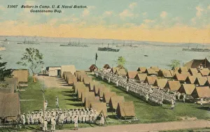
Sailors in Camp, US Naval Station, Guantanamo Bay, c1911. Guantanamo Bay is located at the southeastern end of Cuba and is the largest harbour on the south side of the island
Territorial Divison, (1847), 1920s. Artist: Jose Maria de La TorreTerritorial division. This map was made in1837 by Sir Jose Maria de La Torre, who published another edition in 1847 with the title of History Map old
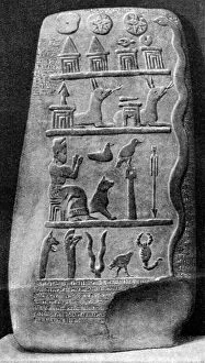
A boundary stone of Babylonia, 1000 BC (1922). Set up to mark the extent of a private individuals estate, the stone is inscribed with certain texts which refer to the ownwership of the land during
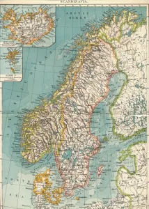
Scandinavia, c1906, (1907). From The Worlds History, Volume VI. Edited by Dr. H. F. Helmolt [William Heinemann, London, 1907]
The dominions of the Angevins, 1892. The territiories ruled by Henry II of England and his successors, Richard I and John
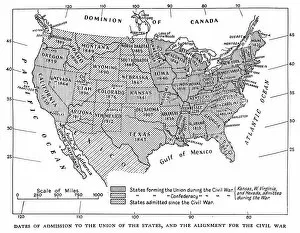
Dates of admission to the Union of the States, and the alignment for the civil war, 1933. Published in The American Presidents, (London, 1933)
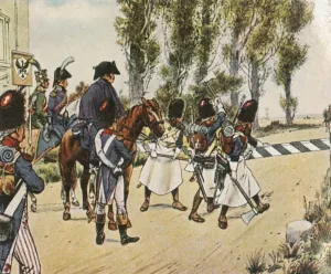
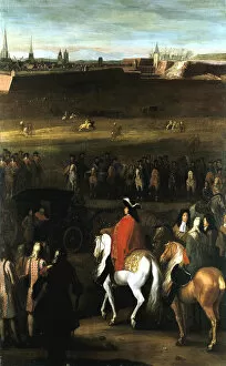
The Great Battles of Louis XIV: Reduction of the Citadel of Cambrai, 1677. King Louis XIV of France (1638-1715), mounted on a white horse, receives the surrender of the city at the end of the siege
North American Huron Indians hunting and preparing food in woodland, 1686North American Huron Indians of what is now Virginia, hunting and preparing food in woodland. From Allain Manesson Mallet Description de l Universe.. Frankfurt-am-Main, 1686. Copperplate engraving
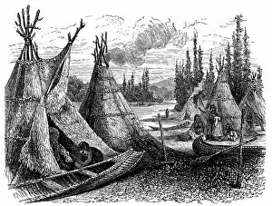
North American Cree Indian settlement in summer, 1874. Wood engraving
North America Indian encampment in Oklahoma, 1889North America Indian encampment in Oklahoma Indian territory, 1889. Wood engraving
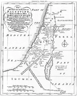
Map of Palestine based on ancient authors, c1830Map of Palestine showing distances in Roman miles, based on various ancient authors and the Jerusalem Itinerary. Engraving c1830