mail_outline sales@mediastorehouse.com
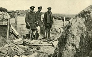
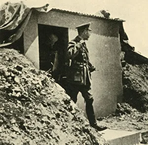
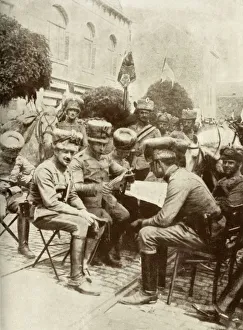
Inspecting One of the German Trenches after its Capture, First World War, 1917, (c1920)Inspecting One of the German Trenches after its Capture by the British Troops, First World War, 1917, (c1920). British army officers on the Western Front
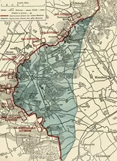
Map to illustrate the Battle of Messines, First World War, June 1917, (c1920). Creator: UnknownMap to illustrate the Battle of Messines, First World War, June 1917, (c1920). The blue area shows ground gained from the Germans by the British under General Sir Herbert Plumer, 7-14 June 1917
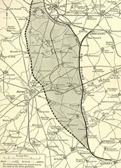
The Battlefield of Arras, First World War, c1917, (c1920) Creator: UnknownThe Battlefield of Arras, First World War, c1917, (c1920)...map showing approximately (by the shaded portion) the ground won by the British armies up to the [German Field Marshal von] Hindenburg
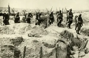
French soldiers... Champagne, France, First World War, 1915-1916, (c1920). Creator: UnknownFrench soldiers occupy captured German trenches, Champagne, northern France, First World War, 1915-1916, (c1920). The Armoured Man and the Armoured Trench: French soldiers
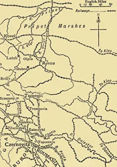
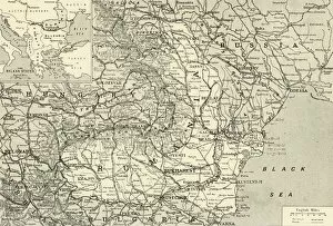
Map illustrating General Ivanoffs operations... First World War, 1915, (c1920)Map illustrating General Ivanoffs operations south of the Pripet Marshes and in Galicia, Eastern Europe, First World War, 1915, (c1920)
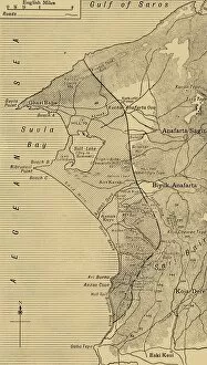
The Suvla and Anzac Line, First World War, August 1915, (c1920). Creator: UnknownThe Suvla and Anzac Line, First World War, August 1915, (c1920)....map showing approximately by the shaded portion the area occupied after the linking up of the two armies in August, 1915
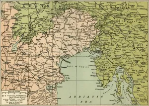
Map showing the Area over which the Italians advanced into Austrian Territory... 1915, (c1920)Map showing the Area over which the Italians advanced into Austrian Territory on the Isonzo Front in 1915, (c1920). The city of Trieste, which had been part the Austro-Hungarian Empire
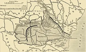
Map illustrating the Roumanian Campaign to the end of 1916, (c1920). Creator: UnknownMap illustrating the Roumanian Campaign to the end of 1916, (c1920). Map of part of eastern Europe, showing German occupation of Rumania during the First World War
King George V visits the front, northern France, First World War, 1917, (c1920). Creator: UnknownKing George V visits the front, northern France, First World War, 1917, (c1920). His Majestys Fourth Visit to his Armies in the Field
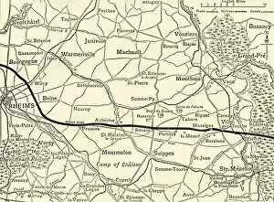
The Battle-fields of Champagne, First World War, 1915, (c1920). Creator: UnknownThe Battle-fields of Champagne, First World War, 1915, (c1920)....map showing approximately the French line between Rheims
Map indicating the Position of the Allied Naval Victory in the Baltic, 1916. Creator: UnknownMap indicating the Position of the Allied Naval Victory in the Baltic, 1916. A British submarine flotilla operated in the Baltic Sea for three years during the First World War, on 19 August 1915
The First V. C. ever Won by a Territorial, 1916. Creator: UnknownThe First V.C. ever Won by a Territorial, 1916. Second-Lieut. G. H. Woolley s. defence of Hill 60 made him the first British Territorial Army officer to be awarded the Victoria Cross
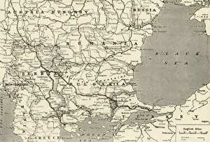
Map Showing the Relation of Serbia to Neighbouring States, 1916. Creator: UnknownMap Showing the Relation of Serbia to Neighbouring States, 1916. The Serbian campaign was fought from late July 1914, when Austria-Hungary invaded Serbia at the outset of World War I
German Troops Occupying the City of Liege, 1915 Creator: UnknownGerman Troops Occupying the City of Liege While the Forts Still Thundered Defiance of the Invaders Advance, 1915. The attack on Liege, a town protected by a ring fortress
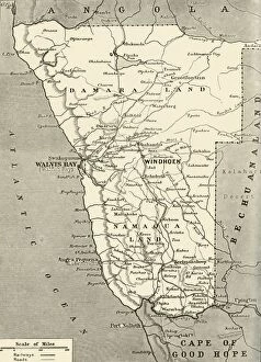
The New Territory which General Botha added to the Empire, 1916. Creator: UnknownThe New Territory which General Botha added to the Empire, 1916. General Botha declared the Transvaal to the British Empire and represented the Boers in peace negotiations
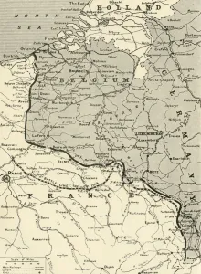
The French Battle-Front in 1914 and 1915, 1916. Creator: UnknownThe French Battle-Front in 1914 and 1915, 1916. Following the outbreak of war in August 1914, the German Army opened the Western Front by invading Luxembourg and Belgium
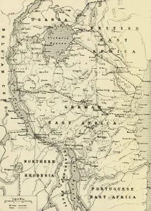
The Last German Colony, East Africa, 1916. Creator: UnknownThe Last German Colony, East Africa, 1916. General Lettow-Vorbeck led the German military in East Africa, his guerilla tactics compelled Britain to commit significant resources to a minor colonial
Map Indicating the Area of the Rumanian Campaign, 1917. Creator: UnknownMap Indicating the Area of the Rumanian Campaign, 1917. From " The War Illustrated Album De Luxe - Volume VII. The Autumn Campaign of 1916", edited by J. A. Hammerton
The Flower of the German Army in the Brussels Parade, 1915. Creator: UnknownThe Flower of the German Army in the Brussels Parade, 1915. The German occupation of Belgium began in August 1914, hussars prepare for a parade
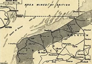
The Belgian Court, 1915. Creator: UnknownThe Belgian Court, 1915. In November 1914, the British declared the entire North Sea a war zone and from then it was mined
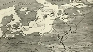
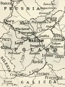
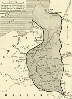
Map of Poland Showing Russian Territory Occupied by Germany in August, 1915, 1916. By the end of 1915, the Germans had occupied the entire Russian sector, including Warsaw
General Map of the Balkan Operations in the Autumn of 1916, 1917. Creator: UnknownGeneral Map of the Balkan Operations in the Autumn of 1916, 1917. The Balkans campaign was fought between the Central Powers and the Allies
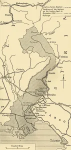
Area of General Cadornas Triumph on the Lower Isonzo, 1917. Creator: UnknownArea of General Cadornas Triumph on the Lower Isonzo, 1917. The Battles of the Isonzo were fought between Austro-Hungarian
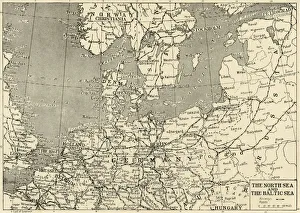
The North Sea and The Baltic Sea, 1915. Creator: UnknownThe North Sea and The Baltic Sea, 1915. The Netherlands remained neutral during World War I but following the Race to the Sea, both sides dug fortified trenches
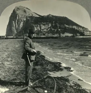
The Rock of Gibraltar, Great Britains Stronghold at the Tip of Spain, c1930s. Creator: UnknownThe Rock of Gibraltar, Great Britains Stronghold at the Tip of Spain, c1930s. From " Tour of the World". [Keystone View Company, Meadville, Pa. New York, Chicago, London]
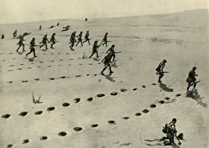
The Desert Phase of the South-West African Campaign... First World War, 1915, (c1920)The Desert Phase of the South-West African Campaign: Union Troops plodding forward under fire, First World War, 1915, (c1920)
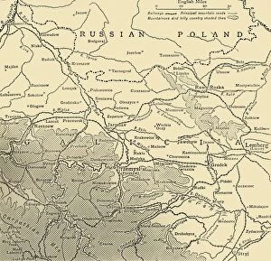
The Galician Campaign, First World War, c1915, (c1920). Creator: UnknownThe Galician Campaign, First World War, c1915, (c1920). Map showing Przemysl in relation to Lemberg. Austrian prisoners of war marched the sixty miles to Lemberg after surrendering to the Russians at
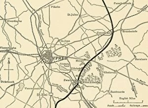
German positions near Ypres, Flanders, First World War, 1915, (c1920). Creator: UnknownGerman positions near Ypres, Flanders, First World War, 1915, (c1920). Map of the Environs of Ypres, showing approximately the German line after the battles of St. Eloi and Hill 60
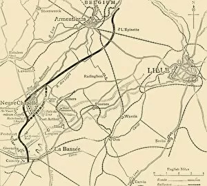
The Battleground of Neuve Chapelle, First World War, 1915, (c1920). Creator: UnknownThe Battleground of Neuve Chapelle, First World War, 1915, (c1920). Map showing the British positions on the eve of the attack, and the British line before and after the fighting of March 10-14
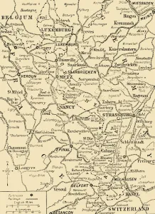
Map showing the border between France and Germany, First World War, c1915, (c1920). The Franco-German Frontier, disputed territory
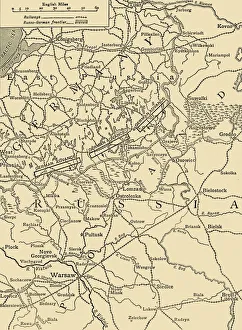
Sketch Map to Illustrate the German Attack north of Warsaw in February, 1915, (c1920). Map showing German positions near the Russo-German frontier during the First World War
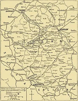
The Polish Campaign, 1914, (c1920). Creator: UnknownThe Polish Campaign, 1914, (c1920)....map illustrating the struggle for Warsaw, October-December (1914), showing German and Austro-Hungarian lines of advance during the First World War
Belgian, British and French positions, First World War, 1915, (c1920). Creator: UnknownBelgian, British and French positions, First World War, 1915, (c1920). " Joffres Wall" : the Allies line in France and Belgium at the beginning of February
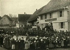
A village in Alsace is occupied by French troops, First World War, c1915, (c1920). " Children of Alsace, salute the Flag of France
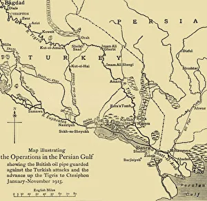
British oil pipeline in the Middle East, First World War, 1915, (c1920). Creator: UnknownBritish oil pipeline in the Middle East, First World War, 1915, (c1920). Map illustrating the Operations in the Persian Gulf; showing the British oil pipe guarded against the Turkish attacks
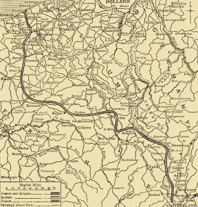
Land taken by Germany from Russia, First World War, 1915, (c1920). Creator: UnknownLand taken by Germany from Russia, First World War, 1915, (c1920). The Germanic Slice out of Russian Territory to the end of the Summer Campaign of 1915...territory gained by the Germans
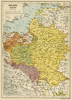
Poland, 1815-1914, (c1920). Creator: John Bartholomew & SonPoland, 1815-1914, (c1920). Map showing Polish territory from the end of the 18th century until the First World War: Poland as constituted in 1815, and Poland before partition of 1772
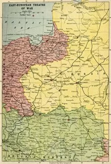
East-European Theatre of War, 1914-1918, (c1920). Creator: John Bartholomew & SonEast-European Theatre of War, 1914-1918, (c1920). Map of Eastern Europe during the First World War, showing parts of Germany, Russia and Austria-Hungary
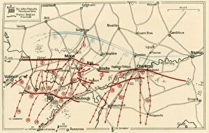
Sketch of the Chief Operations Near Mons and Charleroi, c1914, (c1920). Creator: UnknownSketch of the Chief Operations Near Mons and Charleroi, c1914, (c1920). British, French and German positions in northern France and Belgium at the start of the First World War
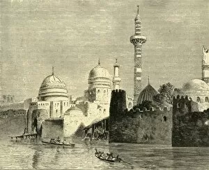
Mosul, Chief Town of Al-Jezireh (Mesopotamia), 1890. Creator: UnknownMosul, Chief Town of Al-Jezireh (Mesopotamia), 1890. Mosul city on the Tigris river in Iraq, in late 9th century was seized by Turkish dynasts
Approach to Antioch, 1890. Creator: UnknownApproach to Antioch, 1890. Ancient Greek city on the eastern side of the Orontes River, founded 4th century BC by Seleucus I Nicator
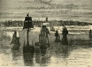
Dunkirk, 1890. Creator: UnknownDunkirk, 1890. Disputed territory between Spain, the Netherlands, England and France in 16th century, Dunkirk wassold to France by Charles II for £ 320, 000 in 1662
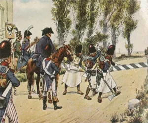
Napoleons troops during the war against Austria, October 1805, (1936). Creator: UnknownNapoleons troops during the war against Austria, October 1805, (1936). Die Truppen Napoleons I Uberschreiten Im Kriege Gegen Osterreich, Oktober 1805
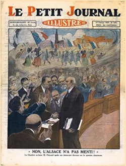
No, Alsace did not lie!, 1929. Creator: UnknownNo, Alsace did not lie!, 1929. Non, l Alsace n a Pas Menti!. Fellow politicians congratulate President of the French Republic Raymond Poincare after his moving speech on the Alsace question
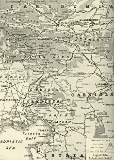
Map of the Italian Fighting Front, 1919. Creator: George Philip & Son LtdMap of the Italian Fighting Front, 1919. Map showing north-eastern Italy, the Trentino and part of southern Austria during the First World War, 1914-1919
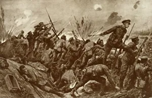
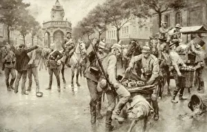
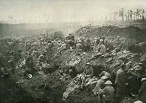
Consolidating A Captured Position, (1919). Creator: UnknownConsolidating A Captured Position, (1919). Scene from the First World War, 1914-1919, British soldiers in enemy trenches: Not the least important part of " consolidating" a captured
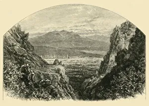
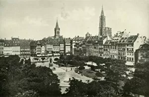
Strasburg, (1919). Creator: UnknownStrasburg, (1919). View of the city of Strasbourg which has at different periods in history been part of Germany and of France
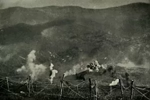
Fighting for the Lost Province of Alsace, (1919). Creator: UnknownFighting for the Lost Province of Alsace, (1919). Scene from the First World War, 1914-1919: The marvellous effect of the French artillery on the German lines on the Alsatian frontier...An artillery