mail_outline sales@mediastorehouse.com
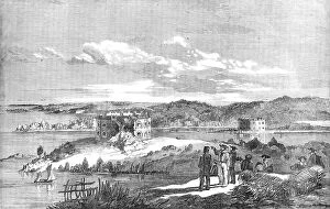
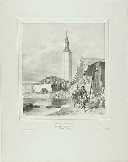
Fort Nottich, Bomarsund - Breach made by an English Three-gun Battery - from a sketch by... 1854. Creator: UnknownFort Nottich, Bomarsund - Breach made by an English Three-gun Battery - from a sketch by O.W. Brierly, 1854. Crimean War: view of the Russian-held Notvik Tower and Prasto Tower in Finland
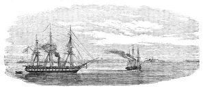
Steam-ships reconnoitring at Sveaborg, in the Gulf of Finland, 1854. Creator: UnknownSteam-ships reconnoitring at Sveaborg, in the Gulf of Finland, 1854. Crimean War: Royal Navy ships off Russian-held Sveaborg [modern Suomenlinna]
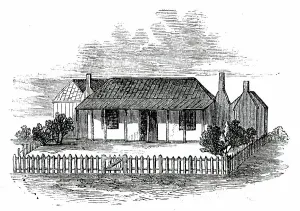
Settler's Station in Port Phillip, 1850. Creator: UnknownSettler's Station in Port Phillip, 1850. Sketch of the usual hut or "station" seen in the interior of the colony of Port Phillip, Australia
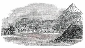
Tigre Island, 1850. Creator: UnknownTigre Island, [now in Honduras], 1850. From "Illustrated London News", 1850. Sketch by "a Traveller in Central America"...of...the interior of the island
Turn by the Belltower, Framework Pending the Turkish Occupation, 1839. Creator: Auguste RaffetTurn by the Belltower, Framework Pending the Turkish Occupation, 1839
Neutralia, 1915. Creator: Edvard MunchNeutralia, 1915
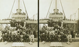
Sailors, probably American, and some civilians posed on a cruiser berthed in New York(?), c1905
Japanese soldiers on a beach in Manchuria, c1905. Creator: Underwood & UnderwoodJapanese soldiers on a beach in Manchuria, c1905
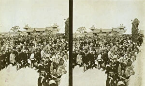
A crowd of Japanese soldiers; Chinese coolies in right foreground, Manchuria, c1905. Creator: Underwood & UnderwoodA crowd of Japanese soldiers; Chinese coolies in right foreground, Manchuria, c1905
Carrying wounded Russian in a jinriksha from the front down to the hospital in Port Arthur, c1905
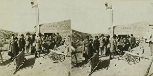
Bicycle stretchers bringing Russian wounded to a surgical station -- siege of Port Arthur, c1905
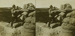
Inside a Russian fort during the siege - shell marks around a dummy gun - Port Arthur, c1905
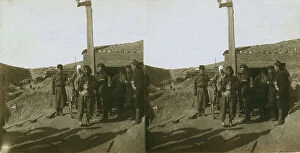
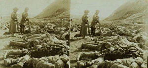
The shattered remains of Russian heroes who were killed near 203 Metre Hill, Port Arthur, c1905
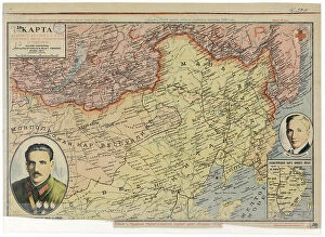
Map of the Far East of the USSR, Northern China (Manchuria) and Mongolia, 1930. Creator: UnknownMap of the Far East of the USSR, Northern China (Manchuria) and Mongolia, 1930. This Soviet-era map is intended to serve a propaganda purpose
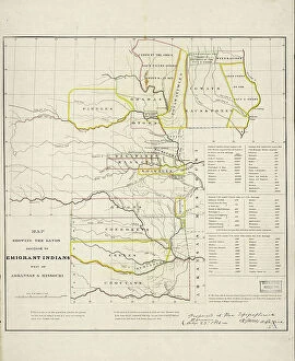
Map showing the lands assigned to emigrant Indians west of Arkansas and Missouri, 1836. Creator: Topographical BureauMap showing the lands assigned to emigrant Indians west of Arkansas and Missouri, 1836. Following passage of the Indian Removal Act in 1830
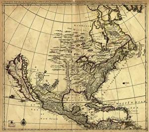
North America divided into its III principall [sic] parts, 1685. Creator: Philip LeaNorth America divided into its III principall [sic] parts, 1685. This map, North America Divided into its III Principal Parts
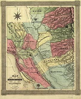
Map of the mining district of California, 1851. Creator: William A. JacksonMap of the mining district of California, 1851. This map, produced in two parts in the early years after the California Gold Rush of 1849
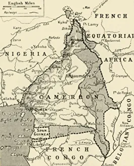
Map Showing the German Cameroon Colony, 1916. Creator: UnknownMap Showing the German Cameroon Colony, 1916. German Cameroon was an African colony of the German Empire from 1884 to 1916
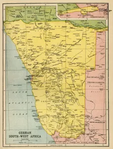
Map of German South West Africa, First World War, (c1920). Creator: John Bartholomew & SonMap of German South West Africa, First World War, (c1920). The German annexation of South West Africa took place in the 1880s
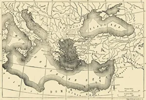
Map of the Byzantine Empire in the Ninth Century, 1890. Creator: UnknownMap of the Byzantine Empire in the Ninth Century, 1890. The Byzantine Empire underwent a revival under Macedonian emperors from Basil I (867-886) in late 9th, 10th, and early 11th centuries
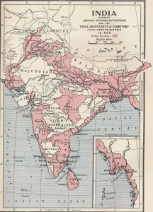
Map of India in 1856 (1906). From Cassells History of England, Vol. VI. [Cassell and Company, Limited, London, Paris, New York & Melbourne, 1906]
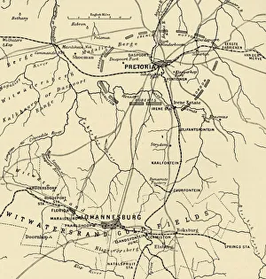
Map Showing District Between Johannesburg and Pretoria, and the Position of the British Forces Round the Latter, 1901. From " South Africa and the Transvaal War, Vol
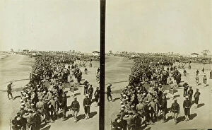
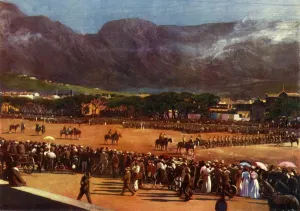
Muster of the Cape Town Guard on the Parade Ground Cape Town, January 12, 1901, 1901Muster of the Cape Town Guard on the Parade Ground Cape Town, for Inspection by General Brabant, January 12, 1901, 1901. British military parade in colonial South Africa
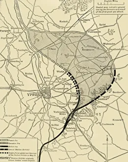
The Ypres Salient before and after the Second Battle of Ypres... First World War, 1915, (c1920)The Ypres Salient before and after the Second Battle of Ypres, April 22-May 13, First World War, 1915, (c1920). Map showing positions of the allied forces around Ypres in Belgium: French
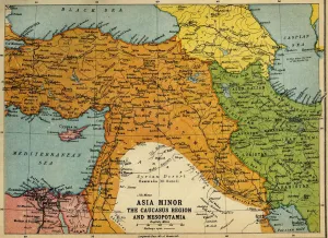
Asia Minor, the Caucasus Region and Mesopotamia, First World War, c1915, (c1920). Map of part of the Middle East, showing eastern Turkey, Cyprus, Syria, Lebanon, Palestine
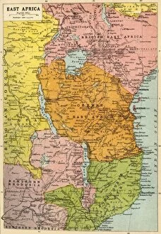
Map of East Africa, First World War, (c1920). Creator: John Bartholomew & SonMap of East Africa, First World War, (c1920). Map showing colonial possessions including the Belgian Congo, British East Africa, German East Africa, Northern Rhodesia and Portuguese East Africa
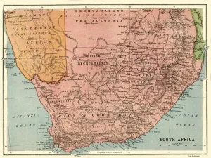
Map of South Africa, c1914, (c1920). Creator: John Bartholomew & SonMap of South Africa, c1914, (c1920). Map of the southern tip of Africa at the start of the First World War, showing German South-West Africa (later Namibia)
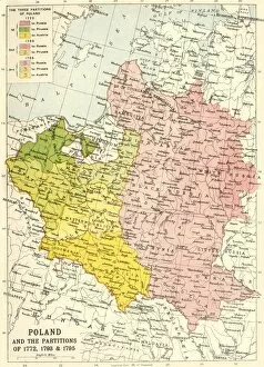
Poland and the Partitions of 1772, 1793 & 1795, (c1920). Creator: John Bartholomew & SonPoland and the Partitions of 1772, 1793 & 1795, (c1920). Map showing how territory in Europe was divided between the empires of Russia, Prussia and Austria in the 18th century
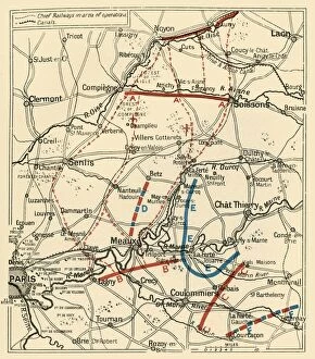
The Second Phase of the Great Retreat... 1914, (c1920). Creator: UnknownThe Second Phase of the Great Retreat: Plan Showing the British Positions from August 28 to September 6, 1914, 1920. The map also indicates the positions of the Allies
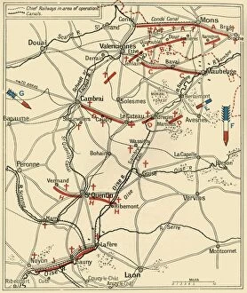
The First Phase of the Great Retreat... 1914, (c1920). Creator: UnknownThe First Phase of the Great Retreat: Plan Showing the British Positions from August 23 to August 28, 1914, (c1920). Map of northern France and Belgium
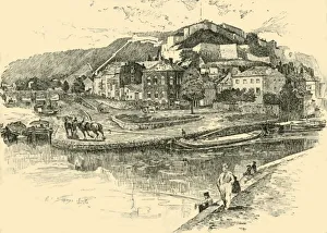
Namur, 1890. Creator: UnknownNamur, 1890. The Citadel of Namur on the confluence of Sambre and Meuse rivers was a disputed territory between Spain, France, England
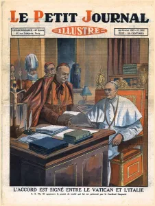
Signing of the accord between the Vatican and Italy, 1929. Creator: UnknownSigning of the accord between the Vatican and Italy, 1929. L Accord Est Signe Entre Le Vatican Et L Italie. The Lateran Treaty, an agreement made between the Kingdom of Italy and the Holy See
The Plantation of Ulster, 17th century, (1948). Creator: UnknownThe Plantation of Ulster, 17th century, (1948). Map: Plan of lands belonging to the Companies of London in Ireland. The Plantation of Ulster was the organised colonisation (plantation)
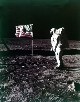
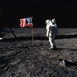
Buzz Aldrin stands next to the American flag on the surface of the Moon, July 1969Buzz Aldrin stands next to the American flag on the surface of the Moon, Apollo 11 mission, July 1969. US astronaut Edwin E " Buzz" Aldrin, Jr
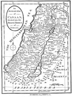
Map of Canaan divided into the twelve tribes of Israel, c1830Map of Canaan divided into the twelve tribes of Israel, 1830. Map of Canaan divided into the territories of the Twelve Tribes of Israel as described in the Bible, Numbers 23:54. Engraving c1830
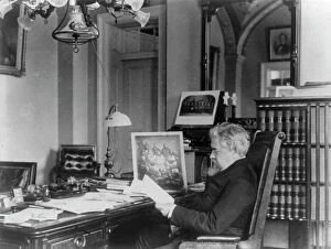
John Willock Noble, 1831-1912, between c1890 and c1910. Creator: Frances Benjamin JohnstonJohn Willock Noble, 1831-1912, between c1890 and c1910. Three-quarter length portrait, seated at desk, left profile. [Politician, lawyer, brigadier general in the Civil War
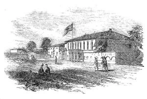
Eupatoria - French Head-Quarters, 1854. Creator: UnknownEupatoria - French Head-Quarters, 1854. Yevpatoria is a city in Western Crimea on the Black Sea. It was the first port landed at by the allies during the Crimean War
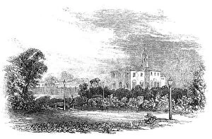
Eupatoria - The Promenade, 1854. Creator: UnknownEupatoria - The Promenade, 1854. Yevpatoria is a city in Western Crimea on the Black Sea. It was the first port landed at by the allies during the Crimean War
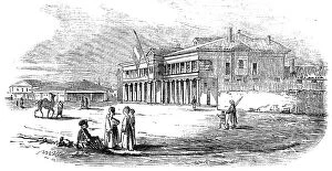
Eupatoria - Jews Synagogue and Schools, 1854. Creator: UnknownEupatoria - Jews Synagogue and Schools, 1854. Yevpatoria is a city in Western Crimea on the Black Sea. It was the first port landed at by the allies during the Crimean War
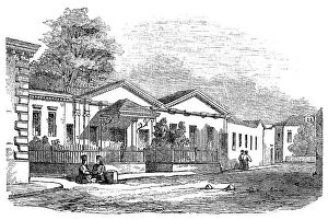
Eupatoria - Residence of Captain Brock, 1854. Creator: UnknownEupatoria - Residence of Captain Brock, 1854. Yevpatoria is a city in Western Crimea on the Black Sea. It was the first port landed at by the allies during the Crimean War
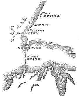
Plan of the Attack at 5.30pm, when these were almost exclusively the Ships engaged with the... 1854 Creator: UnknownPlan of the Attack at 5.30pm, when these were almost exclusively the Ships engaged with the Forts, 1854. Crimean War. Map showing the besieged Black Sea port of Sebastopol
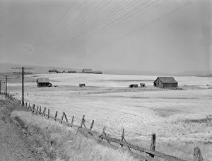
Washington, Klickitat County, near Goldendale, 1939. Creator: Dorothea LangeWashington, Klickitat County, near Goldendale. Wheat country, abandoned farm in foreground, occupied farm beyond. Heard in local filling station: " Well, heck
Buzz Aldrin and the U. S. Flag on the Moon, 1969. Creator: Neil ArmstrongBuzz Aldrin and the U.S. Flag on the Moon, 1969. Astronaut Buzz Aldrin, lunar module pilot of the first lunar landing mission
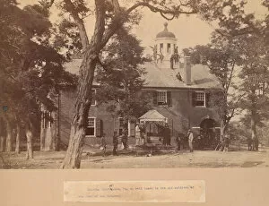
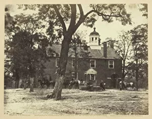
Fairfax Court House, Virginia, with Union Soldiers in Front and on the Roof, 1863. [Fairfax Court House, Va. so well known to the old soldiers of the Army of the Potomac]. Albumen print
Fairfax Court-House, June 1863. Creator: Alexander GardnerFairfax Court-House, June 1863. Union soldiers occupy the court house in Fairfax, Virginia. Albumen print, pl. 3 from the album " Gardners Photographic Sketch Book of the War
Mounting of the Guard, mid 19th century. Creator: RedpathMounting of the Guard, mid 19th century
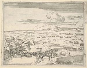
After a Few Days of Seige with the French Army, Francesco I d Este Takes Prossession of Mortara, The Last of his Great Victories, from L Idea di un Principe ed Eroe Cristiano in Francesco I d Este
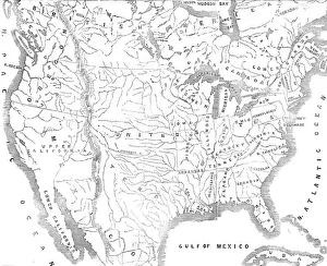
Map of North America, showing the... positions of Texas and Oregon with the United StatesMap of North America, showing the relative positions of Texas and Oregon with the United States, 1845. It may...be requisite to subjoin here a few leading details of the Oregon Territory