mail_outline sales@mediastorehouse.com
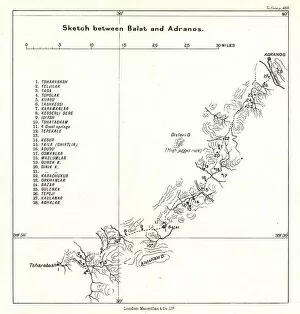
Sketch between Balat and Adranos, c1915. Creator: Stanfords Geographical EstablishmentSketch between Balat and Adranos, c1915. Map showing the journey of British writer, soldier and diplomatic advisor Mark Sykes between Balat and Adranos in Turkey
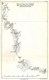
Route to Petra from Teyaha, c1915. Creator: Stanfords Geographical EstablishmentRoute to Petra from Teyaha, c1915. (Note: None of these watercourses contain perennial streams). Map showing the journey of British writer
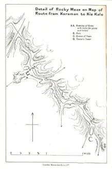
Detail of Rocky Maze on Map of Route from Karaman to Kiz Kale, c1915. Map showing part of the journey of British writer, soldier and diplomatic advisor Mark Sykes between Karaman (in Central Anatolia)
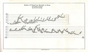
Section of Route from Diarbekir to Sivas and Sivas to Sinope by Aneroid readings, c1915. Map showing the journeys, with altitude above sea level, of British writer
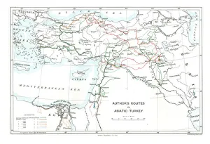
Authors Routes in Asiatic Turkey, c1915. Creator: Stanfords Geographical EstablishmentAuthors Routes in Asiatic Turkey, c1915. Map showing the journeys of British writer, soldier and diplomatic advisor Mark Sykes (1879-1919) who travelled through Palestine, Iraq, Syria
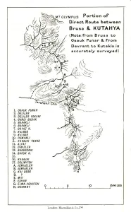
Portion of direct route between Brusa and Kutahya, c1915. (Note: from Brusa to Osauk Punar & from Devrant to Kutakia is accurately surveyed)
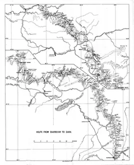
Route from Diarbekir to Zara, c1915. Creator: UnknownRoute from Diarbekir to Zara, c1915. Map showing the journey of British writer, soldier and diplomatic advisor Mark Sykes between Diyarbakir and Zara in Turkey
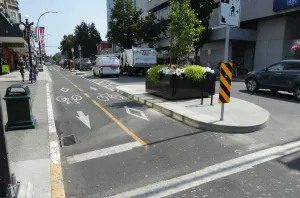
Two-way cycle route in Victoria, Vancouver Island, British Columbia, Canada. Creator: UnknownTwo-way cycle route in Victoria, Vancouver Island, British Columbia, Canada
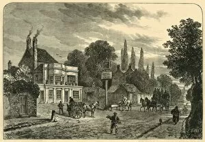
General View of Old Kentish Town, 1820, (c1876). Creator: UnknownGeneral View of Old Kentish Town, 1820, c1876. Originally a small settlement on the River Fleet, Kentish town was modernised from early 20th century with large amounts of land purchased to build
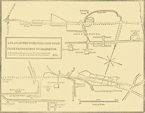
Ground Plan of New Road from Islington to Edgware Road, 1755, (c1876). Creator: UnknownGround Plan of New Road from Islington to Edgware Road, 1755, (c1876). The New Road from Paddington to Islington opened in 1756 as Londons first bypass along which to drive cattle to Smithfield
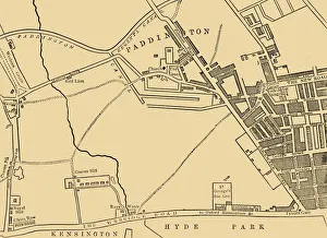
Map of Paddington, in 1815, (c1876). Creator: UnknownMap of Paddington, in 1815, (c1876). Paddington, in the City of Westminster had Roman roads on north-eastern and southern boundaries which became toll roads in 18th century
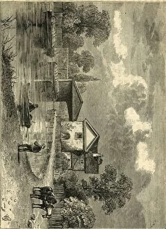
Paddington Canal, 1820, (c1876). Creator: UnknownPaddington Canal, 1820, (c1876). The Paddington arm of the Grand Union Canal was opened on 10 July 1801, authorised by an Act of April 1795 as a water-transport route to the Midlands during
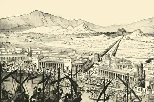
The Piraeus with the Long Walls, Restored, 1890. Creator: UnknownThe Piraeus with the Long Walls, Restored, 1890. The Long Walls connected Athens to the ports of Piraeus and Phalerum. Initially constructed in mid 5th century BC
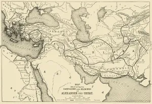
Map Illustrating the Campaigns and Marches of Alexander the Great, 1890. Creator: UnknownMap Illustrating the Campaigns and Marches of Alexander the Great, 1890. Alexander III of Macedon (356-323 BC) spent most of his ruling years on an unprecedented military campaign through Asia
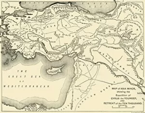
Map of Asia Minor, Expedition of Cyrus the Younger, and Retreat of the Ten Thousand, 1890Map of Asia Minor, showing the Expedition of Cyrus the Younger, and Retreat of the Ten Thousand, 1890. The Ten Thousand were a mainly Greek mercenary force
Map Indicating General Robertss Route to Kabul... and the British and Russian Boundaries, 1901Map Indicating General Robertss Route to Kabul, and Thence to Kandahar, and the British and Russian Boundaries, 1901. The route taken through Afghanistan by British officer Sir Frederick Sleigh
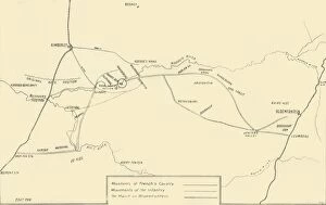
Map Illustrating the Movements for the Relief of Kimberley and the Capture of Bloemfontein, 1901. The key indicates the movements of Major General Frenchs cavalry and of the infantry
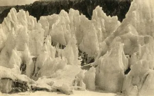
Passage of the East Rongbuk Glacier, c1918-c1939. Creator: UnknownPassage of the East Rongbuk Glacier, c1918-c1939. From an album of postcards
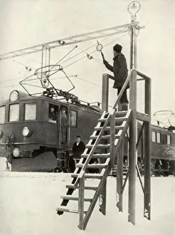
On the Route of the Lapland Express, 1935-36. Creator: UnknownOn the Route of the Lapland Express, 1935-36. From " Railway Wonders of the World, Vol. 2". [The Amalgamated Press Limited, London, 1935-36]
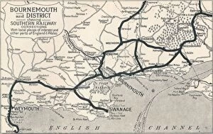
Bournemouth and District, shewing Southern Railway connections, 1929Bournemouth and District, shewing Southern Railway connections. With local places of interest and other parts of England & Wales, 1929
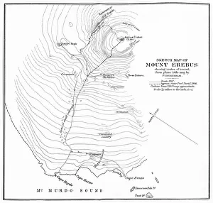
Sketch Map of Mount Erebus showing routes of ascent, c1912, (1913)Sketch Map of Mount Erebus showing routes of ascent, from plane table map by F. Debenham, c1912, (1913). Erebus is the second-highest volcano in Antarctica
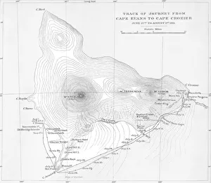
Track of Journey from Cape Evans to Cape Crozier - June 27th to August 1st 1911, (1913). The final expedition of British Antarctic explorer Captain Robert Falcon Scott (1868-1912)
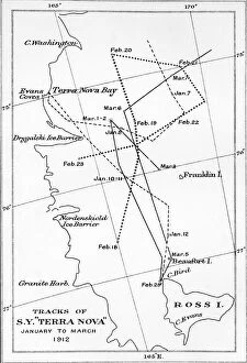
Tracks of S. Y. Terra Nova - January to March 1912, 1913Tracks of S.Y. Terra Nova - January to March 1912, 1913. Map showing routes of the SY (Sailing Yacht or Steam Yacht) Terra Nova which took supplies to expedition members
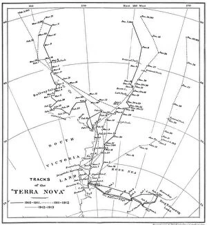
Tracks of the Terra Nova, 1910-1913, (1913). Map showing routes of the SY (Sailing Yacht or Steam Yacht) Terra Nova which took supplies to expedition members
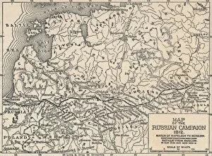
Map of the Russian Campaign, 1812, (1896). Showing the march to and retreat from Moscow of Napoleon Bonaparte (1769-1821) and his French army
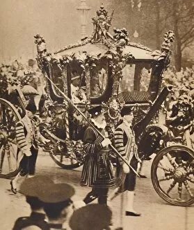
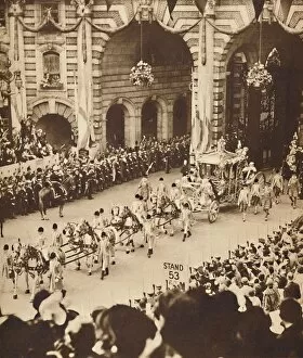
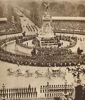
The Golden Coach Leaves the Abbey, May 12 1937. From Coronation Souvenir Book 1937, edited by Gordon Beckles. [Daily Express, London, 1937]
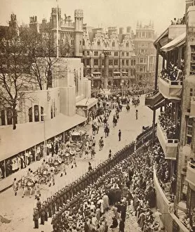
Acclaimed by Thousands at Westminster, May 12 1937. From Coronation Souvenir Book 1937, edited by Gordon Beckles. [Daily Express, London, 1937]
Two Crowns, Two Sceptres, May 12 1937. From Coronation Souvenir Book 1937, edited by Gordon Beckles. [Daily Express, London, 1937]
Sailors Line The Route in Trafalgar Square, May 12 1937. From Coronation Souvenir Book 1937, edited by Gordon Beckles. [Daily Express, London, 1937]
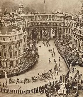
Through the Admiralty Arch, May 12 1937. From Coronation Souvenir Book 1937, edited by Gordon Beckles. [Daily Express, London, 1937]
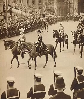
The Kings Personal Aides-De-Camp, May 12 1937. From Coronation Souvenir Book 1937, edited by Gordon Beckles. [Daily Express, London, 1937]
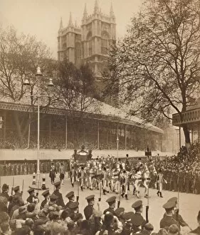
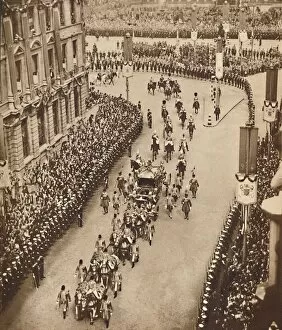
And So Into Whitehall, May 121937And So Into Whitehall, May 12 1937. From Coronation Souvenir Book 1937, edited by Gordon Beckles. [Daily Express, London, 1937]
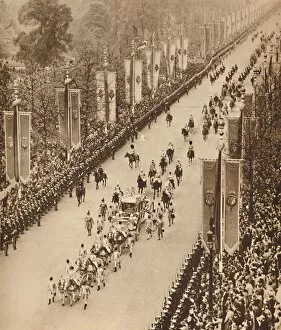
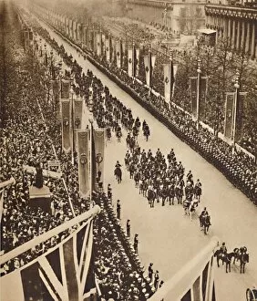
Avenue of Banners, May 12 1937. From Coronation Souvenir Book 1937, edited by Gordon Beckles. [Daily Express, London, 1937]
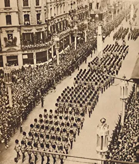
The Guards in Oxford Street, May 12 1937. From Coronation Souvenir Book 1937, edited by Gordon Beckles. [Daily Express, London, 1937]
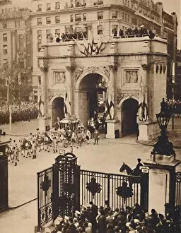
Through the Sovereigns Gate, Marble Arch, May 12 1937. From Coronation Souvenir Book 1937, edited by Gordon Beckles. [Daily Express, London, 1937]
Swinging Down the Mall, May 12 1937. From Coronation Souvenir Book 1937, edited by Gordon Beckles. [Daily Express, London, 1937]
Fanfare of Trumpets, Roll of Drums, May 12 1937. From Coronation Souvenir Book 1937, edited by Gordon Beckles. [Daily Express, London, 1937]
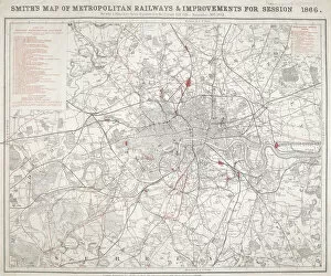
Map of Greater London showing the Metropolitan Railways and improvements in 1866. With a table inset listing the proposed lines
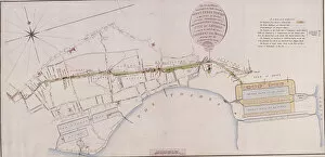
Commercial Road, London, 1801. Artist: William WickingsCommercial Road, London, 1801. A plan of the intended road
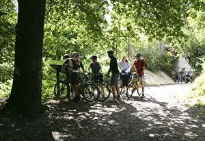
Cyclists, Petts Wood, Kent, 2005
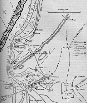
Plans of the Battle of Candahar, (September 1, 1880), c1880. Episode of the Second Anglo-Afghan War, from 1878 to 1880. From British Battles on Land and Sea, Vol. IV, by James Grant
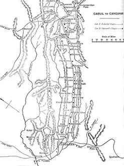
Plan of General Robertss March from Cabul to Candahar, c1880. From British Battles on Land and Sea, Vol. IV, by James Grant. [Cassell Petter & Galpin, London, Paris & Melbourne, c1880]
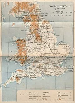
Roman Britain, 1902. Artist: FS WellerRoman Britain, 1902. From Social England, edited by H.D. Traill, D.C.L. and J. S. Mann, M.A. [Cassell and Company, Limited, London, Paris, New York & Melbourne, 1902]
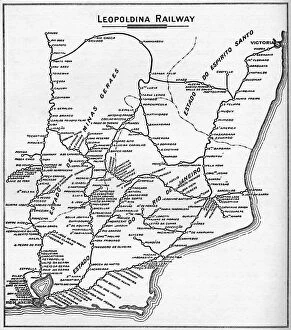
Map of the Leopoldina Railway System, 1914. The three States of Rio de Janeiro, Espirito Santo and Minas Gerais, Brazil. From The Beautiful Rio De Janeiro by Alured Gray Bell
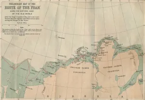
Preliminary Map of the Route of the Fram along Northern Coast of Old World, c1893-1896, (1897)Preliminary Map of the Route of the Fram along Northern Coast of Old World, 1893-1896, (1897). From Farthest North, Vol. 1 by Fridtjof Nansen. [Archibald Constable and Company, London, 1897]
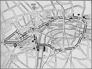
Plan of the route of the Queens procession on Diamond Jubilee Day, London, 1897 (1906). From Cassells History of England, Vol
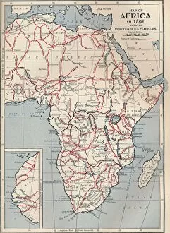
Map of Africa in 1891 showing routes of explorers, 1906. From Cassells Illustrated History of England, Vol. VIII. [Cassell and Company, Limited, London, Paris, New York & Melbourne, 1906]
Pembroke Dockyard and Milford Haven, 1884. From The Illustrated Naval and Military Magazine Volume I [The Illustrated London News, London, 1884]