mail_outline sales@mediastorehouse.com
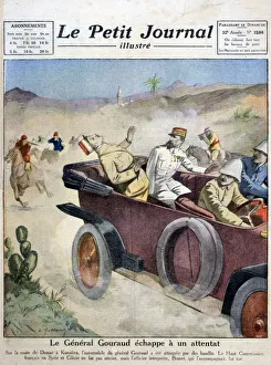
General Gouraud escapes an assassination attempt on route from Damascas to Kunaitra, 1921. General Henri-Joseph-Eugene Gouraud (1867-1946), French High Commissioner of Syria
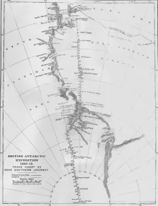
Map - British Antarctic Expedition 1910-13. Track Chart of Main Southern Journey, 1913. The final expedition of British Antarctic explorer Captain Robert Falcon Scott (1868-1912)
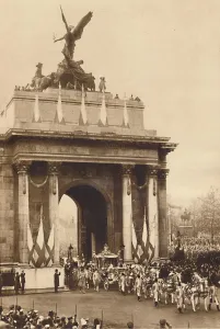
Beneath the Quadriga, May 12 1937. From Coronation Souvenir Book 1937, edited by Gordon Beckles. [Daily Express, London, 1937]
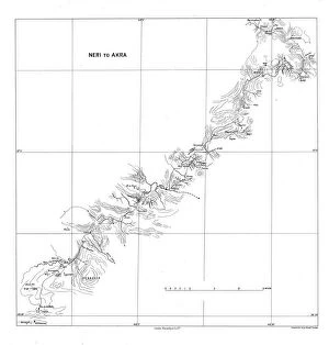
Neri to Akra, c1915. Creator: Stanfords Geographical EstablishmentNeri to Akra, c1915. Map showing the journey of British writer, soldier and diplomatic advisor Mark Sykes in Turkey, (at that time part of the Ottoman Empire)
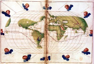
Map of Magellans round the world voyage, 1519-1521. A Portuguese-born navigator sponsored by Spain, Ferdinand Magellan (c1480-1521)
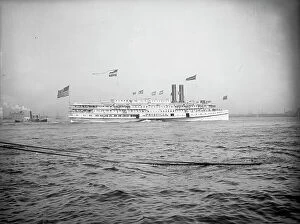
Steamer Priscilla, Fall River Line, c1901. Creator: UnknownSteamer Priscilla, Fall River Line, c1901
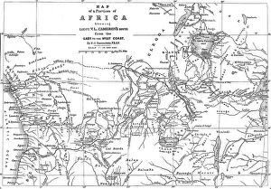
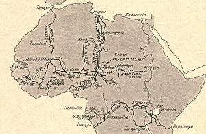
Map of a Portion of Africa, showing...Cameron's Route from the East to the West Coast...1876Map of a Portion of Africa, showing Lieut. V.L. Cameron's Route from the East to the West Coast, 1876. A Map of the entire width of Africa
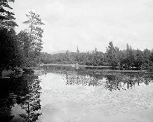
Saranac River below Bartlett's carry, Adirondack Mts. N.Y. between 1900 and 1910. Creator: UnknownSaranac River below Bartlett's carry, Adirondack Mts. N.Y. between 1900 and 1910
Gate of Crawford Notch from below, White Mountains, c1900. Creator: UnknownGate of Crawford Notch from below, White Mountains, c1900
Old studio of artist Hall, near Palenville, Catskill Mountains, N.Y. c1902. Creator: UnknownOld studio of artist Hall, near Palenville, Catskill Mountains, N.Y. c1902
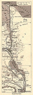
Canal de Suez; Le Nord-Est Africain, 1914. Creator: UnknownCanal de Suez; Le Nord-Est Africain, 1914. From "Grande Geographie Bong Illustree", 1914
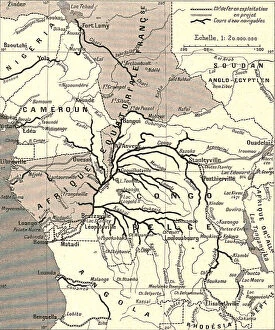
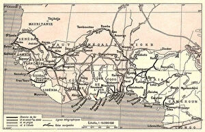
Voies de communication du bassin du Congo; L'Ouest Africain, 1914. Creator: UnknownVoies de communication du bassin du Congo; L'Ouest Africain, 1914. From "Grande Geographie Bong Illustree", 1914
Voies de communication de l'Afrique occidentale francaise; L'Ouest Africain, 1914. Creator: UnknownVoies de communication de l'Afrique occidentale francaise; L'Ouest Africain, 1914. From "Grande Geographie Bong Illustree", 1914
Grands itineraires africains; L'Ouest Africain, 1914. Creator: UnknownGrands itineraires africains; L'Ouest Africain, 1914. From "Grande Geographie Bong Illustree", 1914
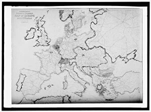
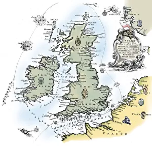
Map of Europe, between 1913 and 1917. Creator: Harris & Ewing. Map of Europe, between 1913 and 1917Map of Europe, between 1913 and 1917. Bartholomew's Railway & Steamship Map of Europe and the Mediterranean
Philip IV Appointing Prince Ferdinand Governor of the Netherlands, plate 25 from Casperius... 1642Philip IV Appointing Prince Ferdinand Governor of the Netherlands, plate 25 from Casperius Gevartius, Pompa Introitus Honori Serenissimi Principis Ferdinandi
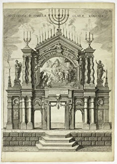
Stage in Memory of Isabella Clara Eugenia, plate 24 from Casperius Gevartius, Pompa Introi... 1642Stage in Memory of Isabella Clara Eugenia, plate 24 from Casperius Gevartius, Pompa Introitus Honori Serenissimi Principis Ferdinandi
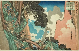
No. 5: Yoshitsune Takes a Shortcut and Scales the Steep and Dangerous Precipice at... c. 1832/34No. 5: Yoshitsune Takes a Shortcut and Scales the Steep and Dangerous Precipice at Hiyodori Pass (Gokai, Kando ni omomuku Yoshitsune Hiyodori goe no kenshun nansho o yojinoboru)
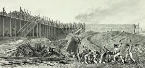
Round Way, from Souvenirs d'Italie: Expédition de Rome, 1859. Creator: Auguste RaffetRound Way, from Souvenirs d'Italie: Expedition de Rome, 1859
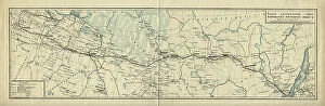
Map of the Route of the Siberian Railway Line, 1891-1916.. Creator: UnknownMap of the Route of the Siberian Railway Line, 1891-1916
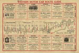
Western motor car route guide, (1915?). Creator: UnknownWestern motor car route guide, (1915?). This automobile guide shows the main highway route between Vancouver, Canada, and San Diego, California, circa 1915
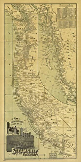
Map showing routes of the Pacific coast Steamship Company, 1891. Creator: Rand McNallyMap showing routes of the Pacific coast Steamship Company, 1891. This foldable tourist brochure, published by Rand McNally and Company in 1891
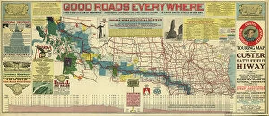
Touring map of the Custer Battlefield Hiway: the scenic route to the west, 1925. Creators: John C. Mulford, C. CTouring map of the Custer Battlefield Hiway: the scenic route to the west, 1925. The Custer Battlefield Highway was created in 1925 as a scenic route between Iowa and Montana
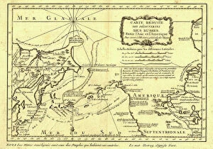
Carte re´duite des de´couvertes des Russes, entre l'Asie et l'Amerique, (1747?). This French map of Alaska, Siberia, and the North Pacific, published in 1747
Millroy's map of Alaska and the Klondyke gold fields, 1897. Creator: J. J. MillroyMillroy's map of Alaska and the Klondyke gold fields, 1897. The Klondike Gold Rush of 1898 began in earnest within 18 months of a major gold strike on Bonanza Creek
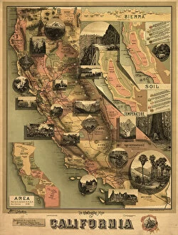
The unique map of California, 1888. Creator: E. McD. JohnstoneThe unique map of California, 1888. It was issued in 1888 by the Southern Pacific Railroad Company and the California State Board of Trade as part of a campaign to promote the economic, cultural
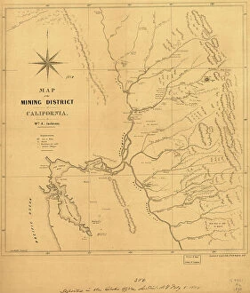
Map of the mining district of California, 1850. Creator: William A. JacksonMap of the mining district of California, 1850. The California gold rush of 1849 began with the strikes at Sutter's Mill on the American River near Sacramento
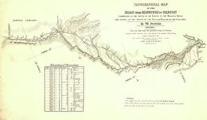
Topographical map of the road from Missouri to Oregon, commencing at the mouth of the Kansas...1846 CreatorsTopographical map of the road from Missouri to Oregon, commencing at the mouth of the Kansas in the Missouri River and ending at the mouth of the Walla-Wallah in the Columbia, 1846
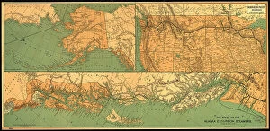
The route of the Alaska excursion steamers, 1891. Creator: Charles Sumner FeeThe route of the Alaska excursion steamers, 1891. This map, published in 1891, shows the excursion steamship routes from Seattle
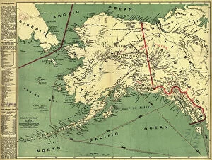
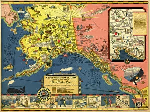
The Alaska Line, 1934. Creator: Alaska Steamship CoThe Alaska Line, 1934. This map, published in 1934 for the tourist market with colorful images and motifs, shows various shipping routes of the Alaska Line
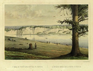
The Amga River on the Route from Yakutsk to Okhotsk, 1856. Creator: Ivan Dem'ianovich BulychevThe Amga River on the Route from Yakutsk to Okhotsk, 1856. From Puteshestviye po Vostochnoy Sibiri I. Bulychova. Chast 1-ya
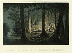
Overnight Camp on the Urak River on the Route to Okhotsk, 1856. Creator: Ivan Dem'ianovich BulychevOvernight Camp on the Urak River on the Route to Okhotsk, 1856. From Puteshestviye po Vostochnoy Sibiri I. Bulychova. Chast 1-ya
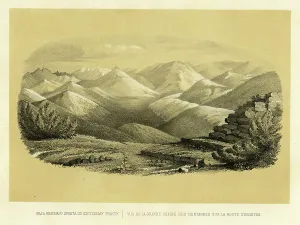
View of the Yablonovy Range on the Route to Okhotsk, 1856. Creator: Ivan Dem'ianovich BulychevView of the Yablonovy Range on the Route to Okhotsk, 1856. From Puteshestviye po Vostochnoy Sibiri I. Bulychova. Chast 1-ya
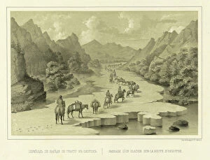
Crossing over the Ice on the Route to Okhotsk, 1856. Creator: Ivan Dem'ianovich BulychevCrossing over the Ice on the Route to Okhotsk, 1856. From Puteshestviye po Vostochnoy Sibiri I. Bulychova. Chast 1-ya. Poyezdka v Kamchatku (A journey across eastern Siberia: Part 1)
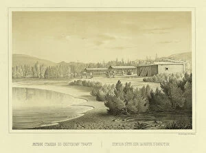
Summer Station on the Route to Okhotsk, 1856. Creator: Ivan Dem'ianovich BulychevSummer Station on the Route to Okhotsk, 1856. From Puteshestviye po Vostochnoy Sibiri I. Bulychova. Chast 1-ya. Poyezdka v Kamchatku (A journey across eastern Siberia: Part 1, Trip to Kamchatka)
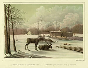
Winter Station on the Route to Okhotsk, 1856. Creator: Ivan Dem'ianovich BulychevWinter Station on the Route to Okhotsk, 1856. From Puteshestviye po Vostochnoy Sibiri I. Bulychova. Chast 1-ya. Poyezdka v Kamchatku (A journey across eastern Siberia: Part 1, Trip to Kamchatka)
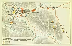
Plan of the Battle of Sekigahara, October 21st 1600, 1903. Creator: UnknownPlan of the Battle of Sekigahara, October 21st 1600, 1903. On October 21, 1600, troops were deployed on the Nakasendo mountain pass for the Battle of Sekigahara
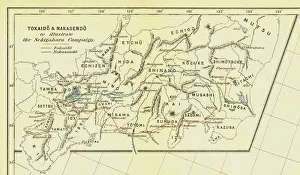
Tokaido & Nakasendo to illustrate the Sekigahara Campaign, 1903. Creator: UnknownTokaido & Nakasendo to illustrate the Sekigahara Campaign, 1903. The Battle of Sekigahara, October 21, 1600 led to establishment of the Tokugawa shogunate
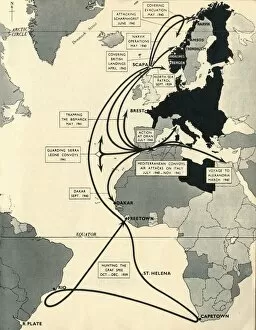
Map showing the movements of HMS Ark Royal, 1939-1941, (1942). Creator: UnknownMap showing the movements of HMS Ark Royal, 1939-1941, (1942). Map of the Atlantic Ocean, western Europe and Africa, indicating journeys
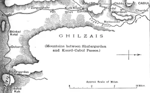
Plan of the Road from the Shutargardan Pass to Cabul, c1880. From British Battles on Land and Sea, Vol. IV, by James Grant. [Cassell Petter & Galpin, London, Paris & Melbourne, c1880]
Chart of the Spanish Armadas course, 1588 (1893). Pines engraving of 1739, of a tapestry then in the House of Lords. An illustration from A Short History of the English People, by John Richard Green
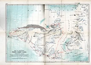
Western Franz Josef Land, 1899. Map showing discoveries and sledge journeys from 1894 to 1897. From an account of the Jackson-Harmsworth Expedition to Franz-Josef Land in the Arctic
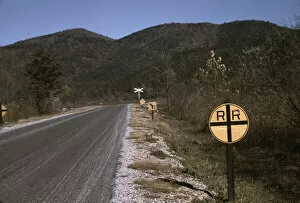
Railroad crossing along the Skyline Drive, Virginia, ca. 1940. Creator: Jack DelanoRailroad crossing along the Skyline Drive, Virginia
View of fields and wooded foothills from the Skyline Drive, Virginia, ca. 1940. Creator: Jack DelanoView of fields and wooded foothills from the Skyline Drive, Virginia
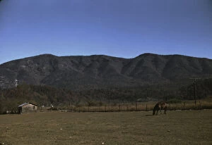
Horse in the pasture of a mountain farm along the Skyline Drive in Virginia, ca. 1940. Creator: Jack DelanoHorse in the pasture of a mountain farm along the Skyline Drive in Virginia
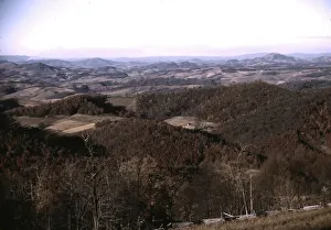
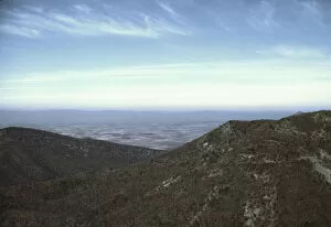
View of a valley from the Skyline Drive, Virginia, ca. 1940. Creator: Jack DelanoView of a valley from the Skyline Drive, Virginia
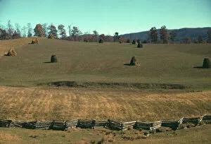
Field of a mountain farm along the Skyline Drive in Virginia, ca. 1940. Creator: Jack DelanoField of a mountain farm along the Skyline Drive in Virginia
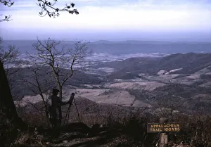
A woman painting a view of the Shenandoah Valley... entrance to the Appalachian Trail, Va, ca. 1940A woman painting a view of the Shenandoah Valley from the Skyline Drive, near an entrance to the Appalachian Trail, Virginia