mail_outline sales@mediastorehouse.com
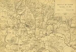
Map of the Battle of Sedan, 1 September 1870, (c1872). Creator: R. WalkerMap of the Battle of Sedan, 1 September 1870, (c1872). Map: Drawn under the Superintendance of Captain Hozier, showing the enemy positions
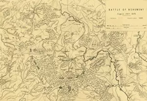
Map of the Battle of Beaumont, 30 August 1870, (c1872). Creator: R. WalkerMap of the Battle of Beaumont, 30 August 1870, (c1872). Map: Drawn under the Superintendance of Captain Hozier, showing the enemy positions
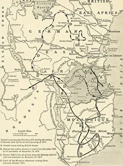
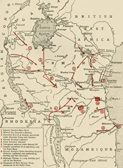
Map illustrating the Closing Phases of the East African Campaign, 1917-18, (c1920). European powers in Africa during the First World War
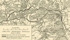
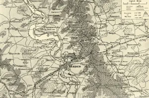
Map illustrating the Operations at Verdun, First World War, August-November, 1917, (c1920). Map of the area around the town of Verdun in northern France, showing Line from which the French started
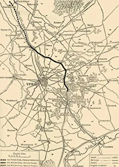
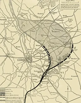
Map of Ypres, West Flanders, Belgium, First World War, (c1920). Creator: UnknownMap of Ypres, West Flanders, Belgium, First World War, (c1920). The Ypres Salient before the Battle of July 31, 1917: map showing the approximate positions of the Franco-British Line
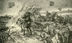
The Pipers at Longueval... July 14, 1916, First World War, (c1920). Creator: UnknownThe Pipers at Longueval: how the Highlanders were led into battle on July 14, 1916, First World War, (c1920). Scots pipers of the 9th (Scottish)
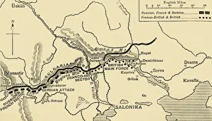
The Allies Line facing the Bulgarians in the closing Campaign of 1916, (c1920). Map of Salonika (Thessaloniki) in Greece, showing Allied positions during the First World War: Russian, French
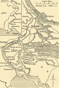
Gorizia and the Carso: map illustrating the Italian advance towards Trieste in 1916, (c1920). Italian lines in northern Italy during the First World War
Colonial possessions in East Africa during the First World War, c1916, (c1920). Creator: UnknownColonial possessions in East Africa during the First World War, c1916, (c1920). Map showing German East Africa, British East Africa, the Belgian Congo, Rhodesia, Uganda
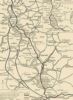
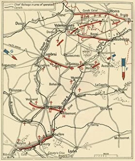
Map illustrating the German Retirement after the Battle of the Somme, (c1920). Creator: UnknownMap illustrating the German Retirement after the Battle of the Somme, (c1920). The First World War Battle of the Somme, fought between the armies of the British Empire
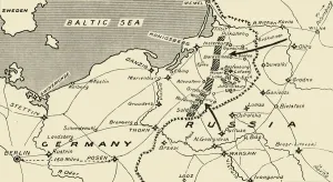
Map illustrating the Russian Invasion of East Prussia, 1915. Creator: UnknownMap illustrating the Russian Invasion of East Prussia, 1915. From August to September 1914, the Russian Empire invaded Germany on the Eastern Front
Large Scale Map of First Phase of the Struggle for Verdun, 1916. Creator: UnknownLarge Scale Map of First Phase of the Struggle for Verdun, 1916. The Battle of Verdun was fought from 21 February to 18 December 1916 on the Western Front
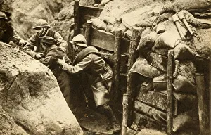
French soldiers raiding a German trench, First World War, 1914-1918, (1933). Creator: UnknownFrench soldiers raiding a German trench, First World War, 1914-1918, (1933). French troops making a daylight raid on the German trenches in search of prisoners for information purposes
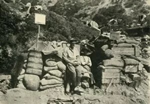
Australian troops in Turkey, First World War, 1915, (c1920). Creator: UnknownAustralian troops in Turkey, First World War, 1915, (c1920). Behind the Firing Line at Anzac Cove: " Splinter Villa", one of the Australian dug-outs
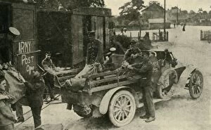
Army post office, First World War, c1915, (c1920). Creator: UnknownArmy post office, First World War, c1915, (c1920). News from Home: the Arrival of the Mails for the Troops at the Front. From " The Great World War - A History" Volume III
The Ypres Salient before and after the Second Battle of Ypres... First World War, 1915, (c1920)The Ypres Salient before and after the Second Battle of Ypres, April 22-May 13, First World War, 1915, (c1920). Map showing positions of the allied forces around Ypres in Belgium: French
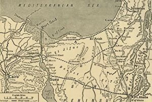
Map of the Turkish attack on the Suez Canal, Egypt, First World War, 1915, (c1920). Map showing approximately the direction of the Turkish Attack on the Suez Canal, January 25 - February 3, 1915
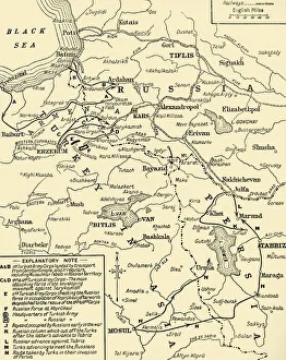
Map of the border between Russia and Turkey, First World War, (c1920). Creator: UnknownMap of the border between Russia and Turkey, First World War, (c1920). Map illustrating Turkeys disastrous Advance in the Caucasus and her Invasion of Persia - December, 1914 - January, 1915
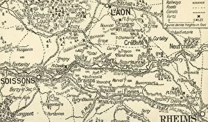
Sketch Map of the Valley of the Aisne above Soissons, 1914, (c1920). Creator: UnknownSketch Map of the Valley of the Aisne above Soissons, 1914, (c1920). Part of northern France, showing Laon and Rheims, at the start of the First World War
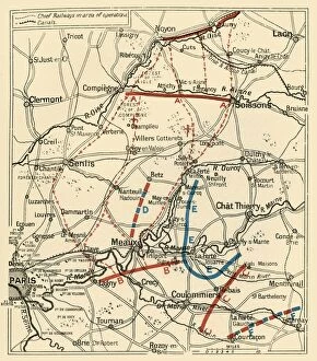
The Second Phase of the Great Retreat... 1914, (c1920). Creator: UnknownThe Second Phase of the Great Retreat: Plan Showing the British Positions from August 28 to September 6, 1914, 1920. The map also indicates the positions of the Allies
The First Phase of the Great Retreat... 1914, (c1920). Creator: UnknownThe First Phase of the Great Retreat: Plan Showing the British Positions from August 23 to August 28, 1914, (c1920). Map of northern France and Belgium
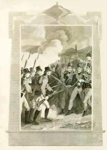
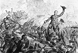
The British attacking French Lines with Bayonets in the Battle of Maida, (1806), 1816The British attacking the French Line with the Bayonet in the Battle of Maida, (1806), 1816. John Stuart led British expeditionary forces against French soldiers under Jean Reynier at the Battle of
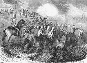
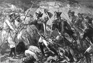
The Black Mountain Expedition, Western Himalayas; Ghazi Fanatics Charging the 18th Royal Irish at Creator: UnknownThe Black Mountain Expedition, Western Himalayas; Ghazi Fanatics Charging the 18th Royal Irish at Kotkai, 1888. From, The Graphic. An Illustrated Weekly Newspaper Volume 38. July to December, 1888
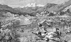
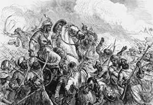
The Battle of Ferozeshah, c1891. Creator: James GrantThe Battle of Ferozeshah, c1891. From " Cassells Illustrated History of India Vol. II.", by James Grant. [Cassell Petter & Galpin, London, Paris and New York]
Fletchers Defence of the Redoubt at Tanjore, c1891. Creator: James GrantFletchers Defence of the Redoubt at Tanjore, c1891. From " Cassells Illustrated History of India Vol. I.", by James Grant. [Cassell Petter & Galpin, London, Paris and New York]
Tippoo Sahib at the Lines of Travancore, c1891. Creator: James GrantTippoo Sahib at the Lines of Travancore, c1891. From " Cassells Illustrated History of India Vol. I.", by James Grant. [Cassell Petter & Galpin, London, Paris and New York]
Captain Yorke Leading the Forlorn Hope at Masulipatam, c1891. Creator: James GrantCaptain Yorke Leading the Forlorn Hope at Masulipatam, c1891. From " Cassells Illustrated History of India Vol. I.", by James Grant. [Cassell Petter & Galpin, London, Paris and New York]
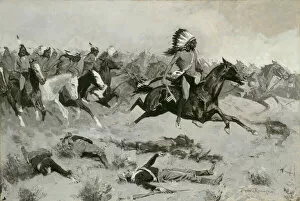
Rushing Red Lodges Passed through the Line, c. 1900. Creator: Frederic RemingtonRushing Red Lodges Passed through the Line, c. 1900
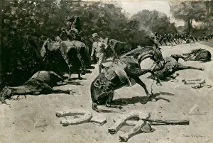
How the Horses Died for Their Country at Santiago, 1899. Creator: Frederic RemingtonHow the Horses Died for Their Country at Santiago, 1899
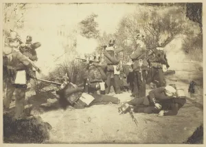
Skirmish between a Prussian Reconnaissance unit and... Faidherbes ArmySkirmish between a Prussian Reconnaissance unit and Advance Troops from Faidherbes Army (Amiens, 21 January 1871) (Escarmouche entre une Reconnaissance prussienne et une Avant-Garde de l Armee de)
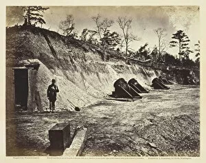
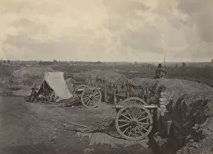
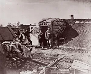
Battery No. 4, Near Yorktown, Virginia, May 1862. Creator: Wood & GibsonBattery No. 4, Near Yorktown, Virginia, May 1862. [Scene from the American Civil War: heavy artillery and earthwork defences]. Albumen print, pl
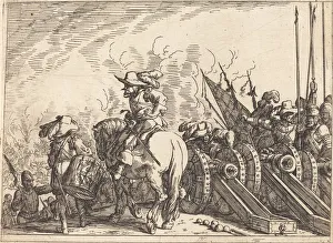
Capricci di varie battaglie, 1635. Creator: Johann Wilhelm BaurCapricci di varie battaglie, 1635
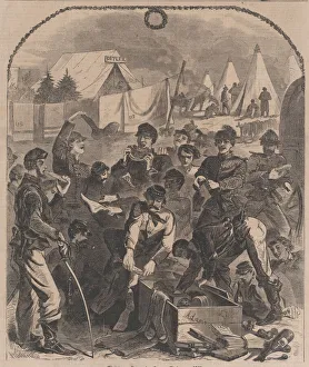
Christmas Boxes in Camp - Christmas, 1861 (Harpers Weekly, Vol. VI), January 4, 1862
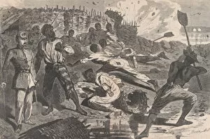
A Shell in Rebel Trenches (Harpers Weekly, Vol. VII), January 17, 1863. Creator: UnknownA Shell in Rebel Trenches (Harpers Weekly, Vol. VII), January 17, 1863
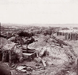
Rebel Works in Front of Atlanta, Georgia No. 4, 1860s. Creator: George N. BarnardRebel Works in Front of Atlanta, Georgia No. 4, 1860s
Rebel Works in Front of Atlanta, Georgia No. 3, 1860s. Creator: George N. BarnardRebel Works in Front of Atlanta, Georgia No. 3, 1860s
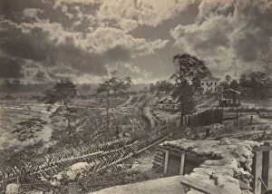
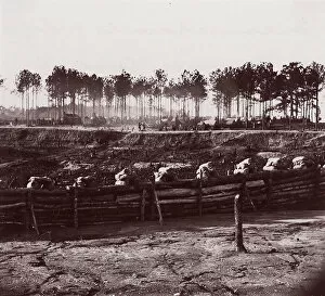
Rebel Works in Front of Atlanta, Georgia No. 1, 1860s. Creator: George N. BarnardRebel Works in Front of Atlanta, Georgia No. 1, 1860s
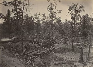
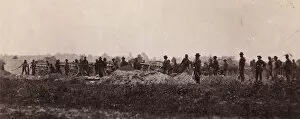
Confederate Earthworks, Centreville, Virginia, 1862. Creator: George N. BarnardConfederate Earthworks, Centreville, Virginia, 1862
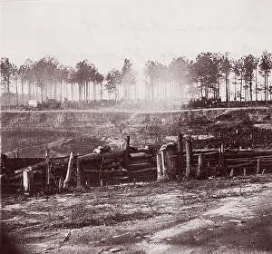
Rebel Works in Front of Atlanta, Georgia No. 2, 1860s. Creator: George N. BarnardRebel Works in Front of Atlanta, Georgia No. 2, 1860s
Battle Field of Atlanta, Georgia, July 22nd 1864 No. 1, 1860s. Creator: George N. BarnardBattle Field of Atlanta, Georgia, July 22nd 1864 No. 1, 1860s
Entrenchments on left of Bermuda Hundred Lines, 1861-65. Creator: Andrew Joseph RussellEntrenchments on left of Bermuda Hundred Lines, 1861-65. Formerly attributed to Mathew B. Brady
Extreme Left of Bermuda Hundred Lines, 1861-65. Creator: Andrew Joseph RussellExtreme Left of Bermuda Hundred Lines, 1861-65. Formerly attributed to Mathew B. Brady
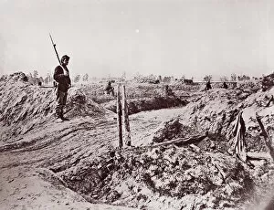
Confederate Fortifications, Petersburg, 1864. Creators: Tim O SullivanConfederate Fortifications, Petersburg, 1864. Formerly attributed to Mathew B. Brady
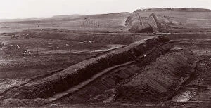
Front of Petersburg Lines, 1864. Creator: Tim O SullivanFront of Petersburg Lines, 1864. Formerly attributed to Mathew B. Brady
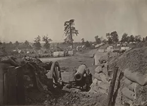
Fort Burnham, front of Petersburg, 1864. Creator: Tim O SullivanFort Burnham, front of Petersburg, 1864. Formerly attributed to Mathew B. Brady
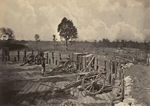
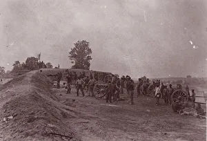
Pennsylvania Light Artillery, Battery B, Petersburg, Virginia, 1864. Formerly attributed to Mathew B. Brady
Outer Confederate Line, Petersburg, Captured June 15, 1864, 1864. Creator: Tim O SullivanOuter Confederate Line, Petersburg, Captured June 15, 1864, 1864. Formerly attributed to Mathew B. Brady
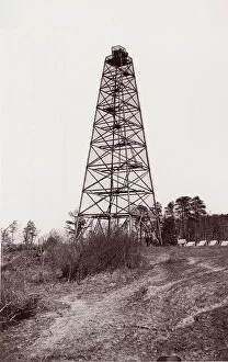
Crows Nest Signal Tower near Bermuda Hundred, 1861-65. Creator: Andrew Joseph RussellCrows Nest Signal Tower near Bermuda Hundred, 1861-65. Formerly attributed to Mathew B. Brady