mail_outline sales@mediastorehouse.com
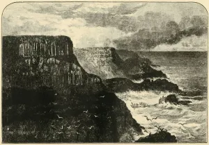
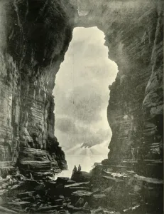
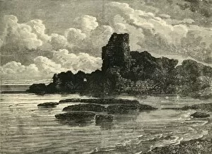
Pleaskin Head, Anrim, 1898. Creator: UnknownPleaskin Head, Anrim, 1898. Pleaskin Head on the Atlantic Ocean at the Giants Causeway in County Antrim with interlocking volcanic basalt columns, is listed as a World Heritage Site
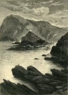
Ilfracombe - View from the Rocks at the Base of the Capstone, 1898. Creator: UnknownIlfracombe - View from the Rocks at the Base of the Capstone, 1898. Natural harbour on the North Devon coast, England a safe harbour since mid-17th century with a light displayed from the 14th
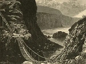
The Bridge, Carrick-A-Rede, 1898. Creator: UnknownThe Bridge, Carrick-A-Rede, 1898. Carrick-a-Rede Rope Bridge near Ballintoy in County Antrim, Northern Ireland connects the mainland with an island over the Atlantic Ocean
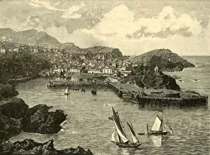
Ilfracombe, 1898. Creator: UnknownIlfracombe, 1898. Seaside resort on the North Devon coast, England, with a small harbour, provided King John with ships and men to invade Ireland in 1208
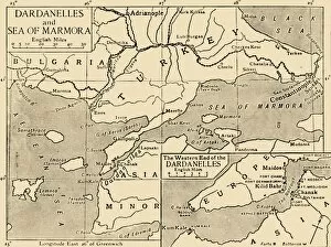
Map of the Dardanelles and Sea of Marmara, c1914, (1920). Creator: UnknownMap of the Dardanelles and Sea of Marmara, c1914, (1920). The coastline around parts of Turkey, Bulgaria, the Black Sea and the Aegean during the First World War
A Coast Scene at Warrnambool, 1901. Creator: UnknownA Coast Scene at Warrnambool, 1901. The first documented European discovery was by Lieutenant James Grant in December 1800, the first settlers arrived in the 1840s
Jubilee Point, Back Beach, Sorrento, 1901. Creator: UnknownJubilee Point, Back Beach, Sorrento, 1901. In 1803, Sullivan Bay in Sorrento became the site of Victorias first mainland European settlement
Low Tide, Shelly Beach, Warrnambool, 1901. Creator: UnknownLow Tide, Shelly Beach, Warrnambool, 1901. The first documented European discovery of Warrnambool was by Lieutenant James Grant
Tasmans Arch, Eagle Hawk Neck, 1901. Creator: UnknownTasmans Arch, Eagle Hawk Neck, 1901. Tasmans arch is a natural bridge on Eaglehawk Neck, an isthmus of the Tasman Peninsula, Tasmania, Australia. From " Federated Australia"
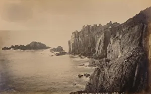
Lands End, Cornwall, 1929. Creator: UnknownLands End, Cornwall, 1929. Headland of granite cliffs at Lands End on the Penwith peninsula, the most westerly point of mainland Cornwall and England
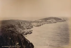
Newquay. The Headland, 1929. Creator: UnknownNewquay. The Headland, 1929
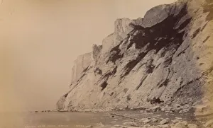
Beachy Head from Beach, 1929. Creator: UnknownBeachy Head from Beach, 1929. The highest chalk sea cliff in Britain, formed in the Late Cretaceous era
Ruins of Caesarea, 1890. Creator: UnknownRuins of Caesarea, 1890. From " Cassells Illustrated Universal History Vol. II - Rome", by Edmund Ollier. [Cassell and Company, Limited, London, Paris and Melbourne, 1890]
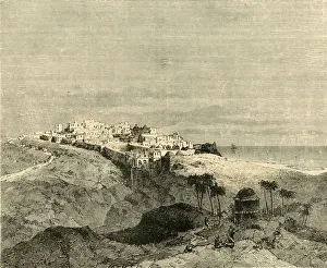
Jaffa, 1890. Creator: UnknownJaffa, 1890. Jaffa, an ancient port city, with a broad view of the Mediterranean Sea, had strategic importance in military history
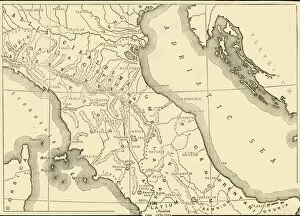
Map of Northern and Central Italy, 1890. Creator: UnknownMap of Northern and Central Italy, 1890. From " Cassells Illustrated Universal History Vol. II - Rome", by Edmund Ollier. [Cassell and Company, Limited, London, Paris and Melbourne, 1890]
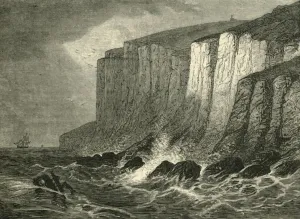
Beachy Head, 1890. Creator: UnknownBeachy Head, 1890. Beachy Head, the highest chalk sea cliff in Britain. From " Cassells Illustrated Universal History, Vol. IV - Modern History", by Edmund Ollier
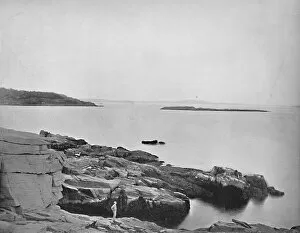
Along the Coast, Bar Harbor, Maine, c1897. Creator: UnknownAlong the Coast, Bar Harbor, Maine, c1897. Bar Harbor, a town on Mount Desert Island in Hancock County, Maine is a popular tourist destination
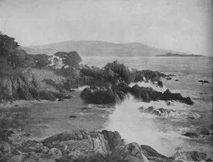
Carmel Bay, California, c1897. Creator: UnknownCarmel Bay, California, c1897. a bay of the Pacific Ocean, along the central coast of California in Monterey County. From " A Tour Through the New World America", by Prof. Geo. R. Cromwell
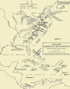
English American Settlements - latter part of 17th Century, 1926. Creators: UnknownEnglish American Settlements - latter part of 17th Century, 1926. Map of the eastern coast of North America, the Caribbean and the north coast of South America, showing areas settled by Europeans
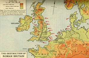
The Destruction of Roman Britain, 1926. Creators: Unknown, Emery Walker LtdThe Destruction of Roman Britain, 1926. Map of Britain showing invasions towards the end of the Roman period (43 to 410 AD)
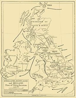
England, Scotland and Ireland - Time of Viking Invasions, 1926. Creators: UnknownEngland, Scotland and Ireland - Time of Viking Invasions, 1926. Map of Britain during the 9th-11th century. Towns of Viking foundation in Ireland underlined
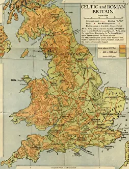
Celtic and Roman Britain, 1926. Creator: Emery Walker LtdCeltic and Roman Britain, 1926. Map of Britain during the Roman (43 to 410 AD) and Celtic periods. All the forts and towns here marked had roads to them, even in the Welsh mountains
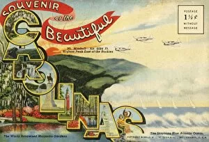
Souvenir of the Beautiful Carolinas postcard, 1942. Creator: UnknownSouvenir of the Beautiful Carolinas postcard, 1942. From " Souvenir of the Beautiful Carolinas". [Curt Teich & Co. Chicago, 1942]
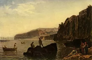
Sorrento, 1828, (1965). Creator: Sil vestr ShchedrinSorrento, 1828, (1965). Men fishing off rocks in the south of Italy. From " Russian Painting of the 18th and 19th Centuries" by Vladimir Fiala. [Artia, Czechoslovakia, 1965]
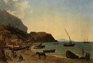
The great Bay of Sorrento - a variation, 1820s, (1965). Creator: Sil vestr ShchedrinThe great Bay of Sorrento - a variation, 1820s, (1965). Boats on the Mediterranean at Marina Grande, Capri, Italy. From " Russian Painting of the 18th and 19th Centuries" by Vladimir Fiala
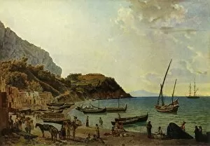
The Great Bay of Sorrento, 1827-1828, (1965). Creator: Sil vestr ShchedrinThe Great Bay of Sorrento, 1827-1828, (1965). The Large Harbour on the Island of Capri. Boats on the Mediterranean at Marina Grande, Capri, Italy. Painting in the State Tretyakov Gallery, Moscow
A Charming View of the Picturesque Coastal Scenery of N. S. W. c1900. Creator: UnknownA Charming View of the Picturesque Coastal Scenery of N.S.W. c1900. From " 50 Picturesque Photographic Views of Sydney and Surroundings". [Swain & Co. Sydney]
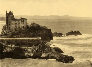
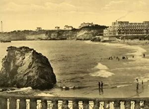
Biarritz - La Cote des Basques, c1930. Creator: UnknownBiarritz - La Cote des Basques, c1930. From " Souvenir de Biarritz". [Labouche Freres - Toulouse]
Biarritz - La Chaine des Pyrenees, c1930. Creator: UnknownBiarritz - La Chaine des Pyrenees, c1930. From " Souvenir de Biarritz". [Labouche Freres, Toulouse]
Biarritz - La Villa Belza et la Chaine des Pyrenees, c1930. Creator: UnknownBiarritz - La Villa Belza et la Chaine des Pyrenees, c1930. From " Souvenir de Biarritz". [Labouche Freres, Toulouse]
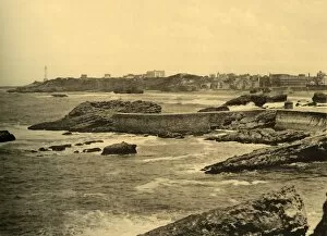
Biarritz - La Digue de la Cafetiere, c1930. Creator: UnknownBiarritz - La Digue de la Cafetiere, c1930. From " Souvenir de Biarritz". [Labouche Freres, Toulouse]
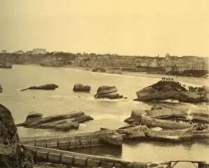
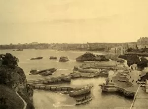
Biarritz - Vue d Ensemble prise de l Atalaye, c1930. Creator: UnknownBiarritz - Vue d Ensemble prise de l Atalaye, c1930. From " Souvenir de Biarritz". [Labouche Freres, Toulouse]
Biarritz - Le Port des Pecheurs, c1930. Creator: UnknownBiarritz - Le Port des Pecheurs, c1930. From " Souvenir de Biarritz". [Labouche Freres, Toulouse]
Biarritz - Hotel du Palais et la Baie, c1930. Creator: UnknownBiarritz - Hotel du Palais et la Baie, c1930. From " Souvenir de Biarritz". [Labouche Freres, Toulouse]
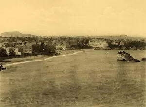
Biarritz - Vue Generale, (General View), c1930. Creator: UnknownBiarritz - Vue Generale, (General View), c1930. From " Souvenir de Biarritz". [Labouche Freres, Toulouse]
The Croisette and Mont Chevalier, Cannes, 1930. Creator: UnknownThe Croisette and Mont Chevalier, Cannes, 1930. From " La Cote d Azur de Marseille a Menton". [Levy & Neurdein, Paris, 1930]
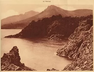
View of Aurelius peak and Cap Roux, Le Trayas, 1930. Creator: UnknownView of Aurelius peak and Cap Roux, Le Trayas, 1930. Cap Roux is a peninsular of Le Trayas, the mountain peak is names after Marcus Aurelius. From " La Cote d Azur de Marseille a Menton"
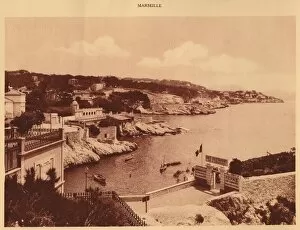
The Corniche, Marseille, 1930. Creator: UnknownThe Corniche, Marseille, 1930. Picturesque seaside roadway that meanders along the Mediterranean coast in Marseille France. From " La Cote d Azur de Marseille a Menton"
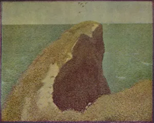
Le Bec Du Hoc, Grandcamp, 1885, (1937). Creator: Georges-Pierre SeuratLe Bec Du Hoc, Grandcamp, 1885, (1937). From " French Painting and the Nineteenth Century", by James Laver. [B. T. Batsford Ltd, London, 1937]
North Coast, Trinidad, B. W. I. c1940s. Creator: UnknownNorth Coast, Trinidad, B.W.I. c1940s. From " Trinidad - British West Indies, Land of the Humming Bird". [Tichnor Quality Views, Boston]
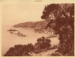
View of the town and Roadstead, Villefranche, 1930. Creator: UnknownView of the town and Roadstead, Villefranche, 1930. From " La Cote d Azur de Marseille a Menton". [Levy & Neurdein, Paris, 1930]
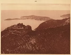
Panorama and Cap Ferrat seen from the Grande Corniche, Eze, 1930. Creator: UnknownPanorama and Cap Ferrat seen from the Grande Corniche, Eze, 1930. From " La Cote d Azur de Marseille a Menton". [Levy & Neurdein, Paris, 1930]
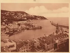
The harbour entrance and Mont-Boron, Nice, 1930. Creator: UnknownThe harbour entrance and Mont-Boron, Nice, 1930. From " La Cote d Azur de Marseille a Menton". [Levy & Neurdein, Paris, 1930]
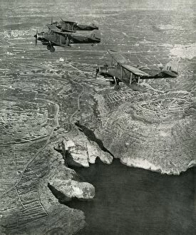
Naval Albacores were part of the striking force, c1942-1943, (1945). Creator: UnknownNaval Albacores were part of the striking force operating from Maltas cratered airfield. In the convoy action shortly to be described, they scored torpedo hits on a cruiser and two destroyers
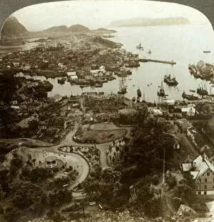
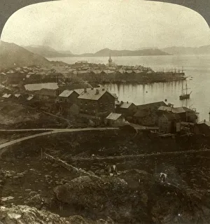
Restoring a burned city - Aalesund, an island port, and important cod-fish market, Norway, c1905. From " The Underwood Travel Library - Norway". [Underwood & Underwood, London ]
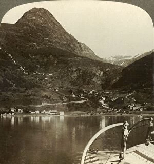
Marok and the giant heights behind it, S. S. E. from Geirangerfjord, Norway, c1905Marok and the giant heights behind it, S.S.E. from Geirangerfjord, Norway, c1905. From " The Underwood Travel Library - Norway". [Underwood & Underwood, London ]
Hammerfest. The worlds northernmost town - no sunset from May 13 to July 29, Norway, c1905. From " The Underwood Travel Library - Norway". [Underwood & Underwood, London ]
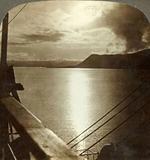
The Midnight Sun in July over cliffs of Spitzbergen and Arctic Ocean, c1905. Creator: UnknownThe Midnight Sun in July over cliffs of Spitzbergen and Arctic Ocean, 78° 15 N. Latitude, c1905. From " The Underwood Travel Library - Norway". [Underwood & Underwood, London ]