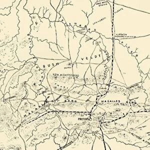
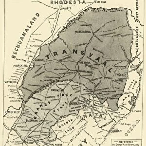
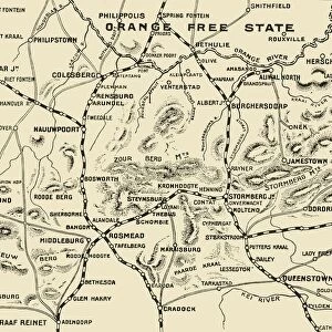
Framed Print : Map Showing District Between Johannesburg and Pretoria, and the Position of the British


![]()
Framed Photos from Heritage Images
Map Showing District Between Johannesburg and Pretoria, and the Position of the British
Map Showing District Between Johannesburg and Pretoria, and the Position of the British Forces Round the Latter, 1901. From " South Africa and the Transvaal War, Vol. V", by Louis Creswicke. [T. C. & E. C. Jack, Edinburgh, 1901]
Media ID 19781233
© The Print Collector/Heritage Images
1899 1902 2nd Boer War Bamp W Boer Wars British Army Creswicke Gauteng Jack Johannesburg Louis Louis Creswicke Occupied Territory Position Pretoria Second Boer War Second Transvaal War South Africa South Africa And The Transvaal War South African Strategic Strategy Tc And Ec Tc And Ec Jack Territorial Territory Transvaal
12"x10" Modern Frame
10x8 Print in an MDF Wooden Frame with 180 gsm Satin Finish Paper. Glazed using shatter proof thin plexi glass. Frame thickness is 1 inch and depth 0.75 inch. Fluted cardboard backing held with clips. Supplied ready to hang with sawtooth hanger and rubber bumpers. Spot clean with a damp cloth. Packaged foam wrapped in a card.
Contemporary Framed and Mounted Prints - Professionally Made and Ready to Hang
Estimated Image Size (if not cropped) is 25.4cm x 25.4cm (10" x 10")
Estimated Product Size is 25.4cm x 30.5cm (10" x 12")
These are individually made so all sizes are approximate
Artwork printed orientated as per the preview above, with landscape (horizontal) or portrait (vertical) orientation to match the source image.
MADE IN THE USA
Safe Shipping with 30 Day Money Back Guarantee
FREE PERSONALISATION*
We are proud to offer a range of customisation features including Personalised Captions, Color Filters and Picture Zoom Tools
SECURE PAYMENTS
We happily accept a wide range of payment options so you can pay for the things you need in the way that is most convenient for you
* Options may vary by product and licensing agreement. Zoomed Pictures can be adjusted in the Cart.