Political Map of Africa, 1914, (1920). Creator: John Bartholomew & Son
. Creator: John Bartholomew & Son")
![]()
Wall Art and Photo Gifts from Heritage Images
Political Map of Africa, 1914, (1920). Creator: John Bartholomew & Son
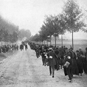
Political Map of Africa, 1914, (1920). Colonial possessions in Africa at the start of the First World War. British colonies are pink, French - green, German - orange, Portuguese - purple, Italian - brown. From " The Great World War - A History" Volume I, edited by Frank A Mumby. [The Gresham Publishing Company Ltd, London, c1920]
Media ID 19174246
© The Print Collector/Heritage Images
Bartholomew Bartholomew And Co Bartholomew Co Bartholomew John Son Colonies Colony Frank Arthur Frank Arthur Mumby French Empire German Empire Gresham Publishing Co Ltd Gresham Publishing Company Imperial Imperialism Jg Bartholomew John And Son John Bartholomew And Co John Bartholomew And Son John Bartholomew And Son Ltd John Bartholomew Co John Bartholomew Son John Bartholomew Son Ltd John Son Keystone Archives Mumby Mumby Frank Arthur The Great World War A History Theatre Of War
MADE IN THE UK
Safe Shipping with 30 Day Money Back Guarantee
FREE PERSONALISATION*
We are proud to offer a range of customisation features including Personalised Captions, Color Filters and Picture Zoom Tools
SECURE PAYMENTS
We happily accept a wide range of payment options so you can pay for the things you need in the way that is most convenient for you
* Options may vary by product and licensing agreement. Zoomed Pictures can be adjusted in the Basket.