Old map of Acadia, 17th century (c1880)
")
![]()
Wall Art and Photo Gifts from Heritage Images
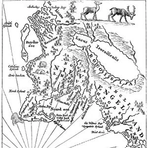
Old map of Acadia, 17th century (c1880)
Old map of Acadia, 17th century (c1880). Acadia (Acadie) was part of the territory claimed by the French in North America from 1604. Corresponding to what is now Nova Scotia, it became a British possession after the Treaty of Utrecht in 1713. A print from Cassells History of the United States, by Edmund Ollier, Volume I, Cassell Petter and Galpin, London, c1880
Media ID 14946121
© The Print Collector / Heritage-Images
Atlantic Ocean Canada Cartography Colony Edmund Edmund Ollier Gulf Map Making Nova Scotia Ocean Ollier
MADE IN THE UK
Safe Shipping with 30 Day Money Back Guarantee
FREE PERSONALISATION*
We are proud to offer a range of customisation features including Personalised Captions, Color Filters and Picture Zoom Tools
SECURE PAYMENTS
We happily accept a wide range of payment options so you can pay for the things you need in the way that is most convenient for you
* Options may vary by product and licensing agreement. Zoomed Pictures can be adjusted in the Basket.