Map showing... the Attack on Verdun northern France, First World War, 1916, (c1920)
")
![]()
Wall Art and Photo Gifts from Heritage Images
Map showing... the Attack on Verdun northern France, First World War, 1916, (c1920)
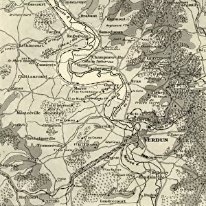
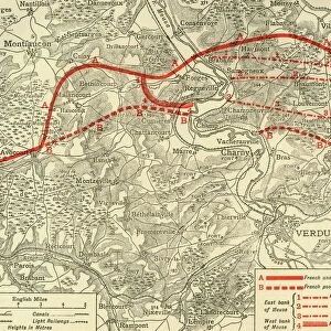
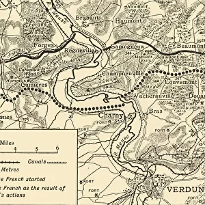
Map showing the Various Stages in the First Phase of the Attack on Verdun northern France, First World War, 1916, (c1920). The German attack on the French lines at Verdun began on the east side of the [River] Meuse at dawn on February 21, 1916. The most northerly line drawn on the map shows the French position at the time of the German onset. The other lines show the successive positions taken up by the French as they were forced back on February 22, 23, 24, and 25. On Friday, February 25, the final adjustment of the French line in the first phase of the struggle east of the Meuse took place. It crossed Poivre Hill and Douaumont Plateau. From " The Great World War: A History", Volume V, edited by Frank A Mumby. [The Gresham Publishing Company Ltd, London, c1920]
Media ID 19664850
© The Print Collector/Heritage Images
Adversary Battle Of Verdun Enemy Frank A Frank A Mumby Frank Arthur Frank Arthur Mumby Front Line Frontline Gresham Publishing Co Ltd Gresham Publishing Company Keystone Archives Lines Lorraine Meuse Mumby Mumby Frank A Mumby Frank Arthur River Maas River Meuse The Great World War A History Theatre Of War Verdun Verdun Meuse Lorraine France
MADE IN THE UK
Safe Shipping with 30 Day Money Back Guarantee
FREE PERSONALISATION*
We are proud to offer a range of customisation features including Personalised Captions, Color Filters and Picture Zoom Tools
SECURE PAYMENTS
We happily accept a wide range of payment options so you can pay for the things you need in the way that is most convenient for you
* Options may vary by product and licensing agreement. Zoomed Pictures can be adjusted in the Basket.