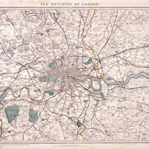
Map of Greater London showing the Metropolitan Railways and improvements in 1866

![]()
Wall Art and Photo Gifts from Heritage Images
Map of Greater London showing the Metropolitan Railways and improvements in 1866
Map of Greater London showing the Metropolitan Railways and improvements in 1866. With a table inset listing the proposed lines. Completed railways are shown in a firm black line, with those in progress or sanctioned represented by a pecked black line. Proposed new lines are shown in red
Media ID 15176032
© London Metropolitan Archives (City of London) / Heritage-Images
London Transport London Underground Metropolitan Railway Plan Proposal Public Transport Railway Line Route
MADE IN THE UK
Safe Shipping with 30 Day Money Back Guarantee
FREE PERSONALISATION*
We are proud to offer a range of customisation features including Personalised Captions, Color Filters and Picture Zoom Tools
SECURE PAYMENTS
We happily accept a wide range of payment options so you can pay for the things you need in the way that is most convenient for you
* Options may vary by product and licensing agreement. Zoomed Pictures can be adjusted in the Basket.