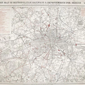
Map of London, c1860. Artist: Benjamin Rees Davies

![]()
Wall Art and Photo Gifts from Heritage Images
Map of London, c1860. Artist: Benjamin Rees Davies
Map of London and surrounding counties along the River Thames from Thames Ditton to Erith, with railway stations marked and the cemeteries coloured in grey
Media ID 15169826
© London Metropolitan Archives (City of London) / Heritage-Images
Cemetery Davies Essex Kent Railway Station Station Surrey Train Station
MADE IN THE UK
Safe Shipping with 30 Day Money Back Guarantee
FREE PERSONALISATION*
We are proud to offer a range of customisation features including Personalised Captions, Color Filters and Picture Zoom Tools
SECURE PAYMENTS
We happily accept a wide range of payment options so you can pay for the things you need in the way that is most convenient for you
* Options may vary by product and licensing agreement. Zoomed Pictures can be adjusted in the Basket.