mail_outline sales@mediastorehouse.com
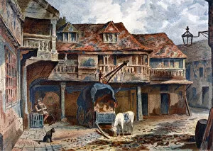
Courtyard of the Tabard Inn, Borough High Street, Southwark, London, 1871. ArtistCourtyard of the Tabard Inn, Borough High Street, Southwark, London, 1871. View with a cart and a horse feeding from a bucket
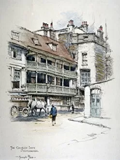
View of the George Inn, Borough High Street, Southwark, London, c1870
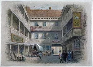
Courtyard of the White Hart Inn, Borough High Street, Southwark, London, c1860. ArtistCourtyard of the White Hart Inn, Borough High Street, Southwark, London, c1860. View with figures and a cart in the yard
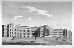
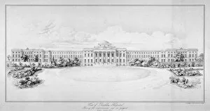
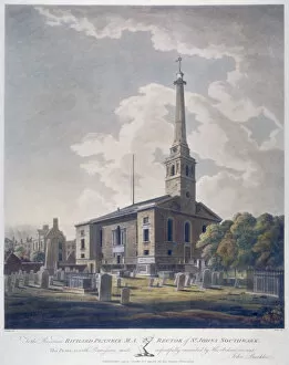
View of the new Bethlem Hospital, St Georges Field, Southwark, London, 1814. ArtistView of the new Bethlem Hospital, St Georges Field, Southwark, London, 1814. The hospital was moved to this site c1815, after the old building was found to be unsound
View of the new Bethlem Hospital, Southwark, London, c1825. The hospital was moved to this site c1815, after the old building was found to be unsound
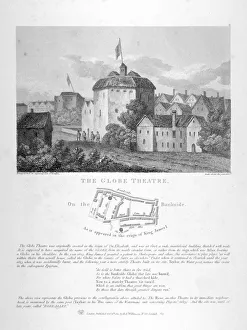
The Globe Theatre, Bankside, Southwark, London, 1810. View with a plan of surrounding streets and a description beneath
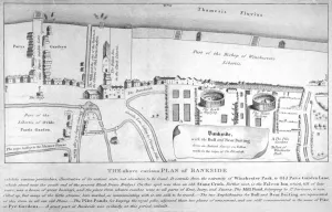
Plan of Bankside, Southwark, London, c1570. Showing the arenas for bull and bear baiting, the pike gardens and Winchester Park
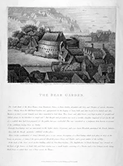
The Bear Garden, Southwark, London, 1810. ArtistThe Bear Garden, Southwark, London, 1810. The site of bear-baiting on Bankside, the Bear Garden stood near the Globe Theatre on the south bank of the Thames. With a description beneath
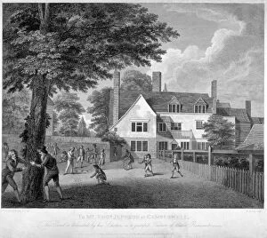
The Camberwell Free Grammar School, Camberwell, London, 1795. ArtistThe Camberwell Free Grammar School, Camberwell, London, 1795. View of the school with children playing in front
View of St Olaves School, Tooley Street, Bermondsey, London, c1820. ArtistView of St Olaves School, Tooley Street, Bermondsey, London, c1820
London and Greenwich Railway bridge over the Neckinger Road, Bermondsey, London, 1836
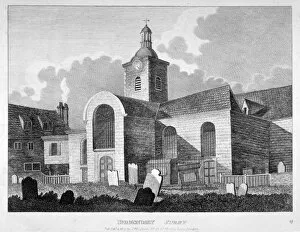
View of the Church of St Mary Magdalen, Bermondsey, London, 1809
View of people attending Peckham Fair, London, c1820. Artist: George ShepherdView of people attending Peckham Fair, London, c1820
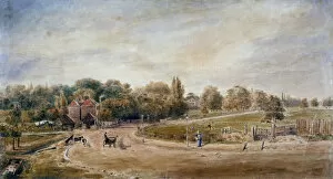
Court Lane and Lordship Lane, Dulwich, London, 1860. Artist: JC MandyCourt Lane and Lordship Lane, Dulwich, London, 1860. View showing cattle grazing and horse-drawn vehicles passing on the road
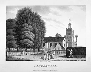
Church of St Giles, Camberwell, London, 1792
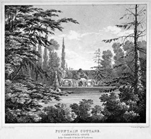
Fountain Cottage, Camberwell Grove, Camberwell, London, c1825. Fountain Cottage belonged to John Coakley Lettsom, a famous physician, botanist
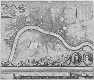
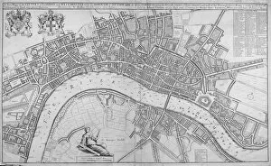
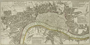
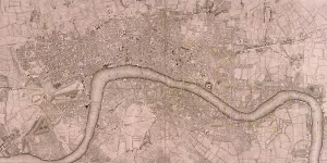
Map of the City of London, City of Westminster, River Thames, Lambeth and Southwark, 1736. Top left shows two elevations of Banqueting House and Treasury
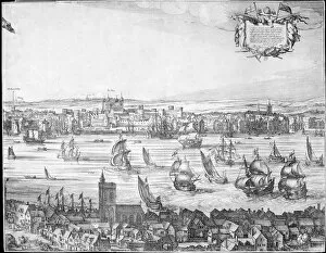
Panorama of London, 1616. Artist: ClaesPanorama of London, 1616. Panoramic view of London from the South Bank looking across the River Thames towards the Tower of London
View of the London Bridge Station, Bermondsey, London, 1845. ArtistView of the London Bridge Station, Bermondsey, London, 1845
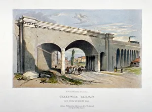
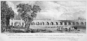
London and Greenwich Viaduct, Bermondsey, London, 1835. ArtistLondon and Greenwich Viaduct, Bermondsey, London, 1835. View of the portion of the London and Greenwich Viaduct which crosses Corbetts Lane
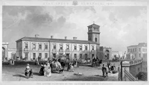
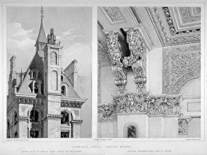
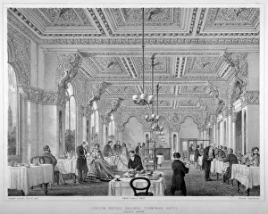
London Bridge Station, Bermondsey, London, 1860. ArtistLondon Bridge Station, Bermondsey, London, 1860. The upper part of the south-east angle of the London Bridge Terminus Hotel on the left, and interior decorations in the coffee room on the right
The coffee room in the London Bridge Railway Terminus Hotel, Bermondsey, London, 1860Interior view of the coffee room in the London Bridge Railway Terminus Hotel, Bermondsey, London, 1860. The hotel, on the south side of the station
View of the Church of St John Horsleydown, Bermondsey, London, 1799
View of King Johns Gate in the Abbey of St Saviour, Bermondsey, London, 1807
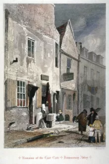
View of the east gate remains of the Abbey of St Saviour, Bermondsey, London, 1851. Also showing figures and household items on the street
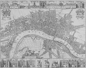
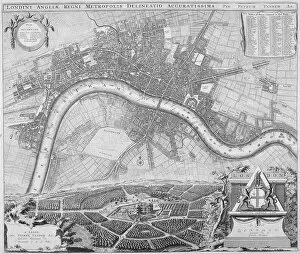
Map of London, 1690. Artist: Johannes de RamMap of London, 1690 Map with a panorama in the lower margin, portraits of William III and Mary II and putti carrying various devices including the City of London and Royal arms
Map of the Cities of London and Westminster, Southwark and the suburbs, 1680. ArtistMap of the Cities of London and Westminster, Southwark and the suburbs, 1680. With the royal arms at top left, a key top right and a female figure holding dividers seated above the scale
Map of the Cities of London and Westminster and Southwark, 1690. With views of buildings and portraits of William III and Mary II in an oval in the top margin and gates
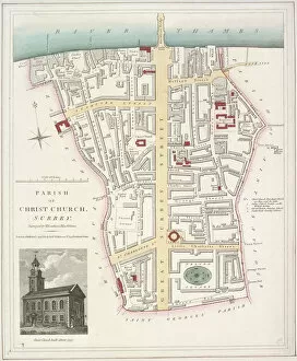
Map of the Parish of Christ Church in Southwark, London, 1821. With an image of the church inset in the bottom left corner
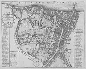
Map of the Parishes of St Georges and St Saviours, Southwark, London, 1755. ArtistMap of the Parishes of St Georges and St Saviour s, Southwark, London, 1755. With keys to the buildings and streets
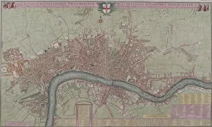
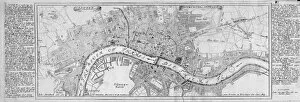
Map of London, 1753. Map of Westminster, the City of London, Southwark, the River Thames and surrounding areas, with two tables detailing Hackney coach fares and watermens fares
Map of London, 1690. The upper section shows a map of the City of London, City of Westminster, River Thames, Lambeth and Southwark. The lower section shows a view of Westwood Park, Worcestershire
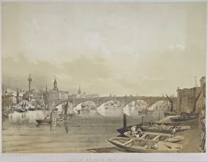
London Bridge, 1852. Artist: William SimpsonLondon Bridge, 1852. View with boats on the River Thames. In the foreground there are boats moored on the south bank with the River Thames at low tide
Map of London, 1725. Map of the City of London, City of Westminster, River Thames, Lambeth, Southwark and surrounding areas
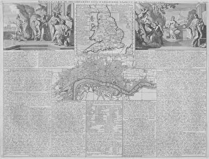
Maps of England, Wales and London, 1718. A map of England, Wales and part of Scotland is placed between two groups of allegorical figures
Map of London, 1700. Artist: Augustae VindelicorumMap of London, 1700. The City of London, City of Westminster, River Thames, Lambeth, Southwark and surrounding areas; either side contains text in German
View of London Bridge from the west with boats on the River Thames, 1829. ArtistView of London Bridge from the west with boats on the River Thames, 1829
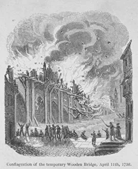
Fire on London Bridge, 1758. View of the fire on 11 April 1758, which destroyed a temporary wooden walkway spanning the centre of London Bridge (shown here on the east side)
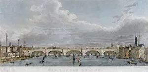
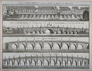
London bridges, 1760. Views of London Bridge before and after the houses on it were pulled down. Also showing views of Westminster Bridge and Blackfriars Bridge
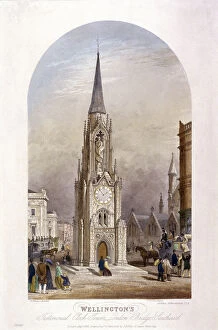
Wellington Clock Tower at the southern end of Southwark Bridge, London, 1854. ArtistWellington Clock Tower at the southern end of Southwark Bridge, London, 1854. With figures and vehicles around it, the clock tower is now at Swanage in Dorset
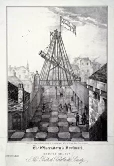
View of The Observatory in Southwark, London, 1835. Artist: Charles BellamyView of The Observatory in Southwark, London, 1835. The Observatory was erected in 1835 for the British Parallactic Society
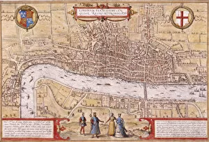
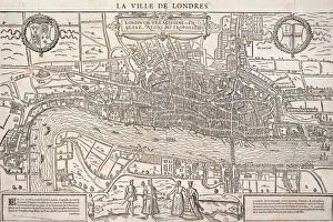
Map of the City of London, Southwark and part of Westminster, 1572
Map of the London showing Civil War fortifications, 1749. Artist: Isaac BasireMap of the City of Westminster, City of London, River Thames and Southwark, 1749. The red line shows Civil War fortifications
Map of the City of London and City of Westminster with four figures in the foreground, (c1572?). Heraldic shield on left depicts the Tudor royal arms and shield on left depicts the City of London arms
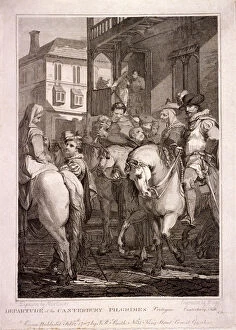
Departure of the Canterbury Pilgrims, Borough High Street, Southwark, London, 1787. An 18th century illustration of Chaucers Canterbury Tales
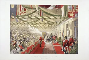
Princess Alexandras arrival at Bricklayers Arms Station, Bermondsey, London, 1863. Princess Alexandra arrives in London for her marriage to King Edward VII
Loyal London Volunteers, 1804. A handwriting broadsheet showing the Loyal London Volunteers embarking from Blackfriars Bridge for a grand field day
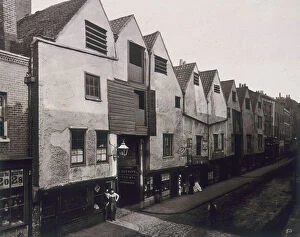
Bermondsey Street, Southwark, London, 1881. Artist: Henry DixonView of figures and shops on Bermondsey Street, Southwark, London, 1881