mail_outline sales@mediastorehouse.com
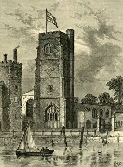
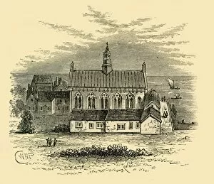
Lambeth Church (1825), (c1878). Creator: UnknownLambeth Church (1825), (c1878). The church of St Mary-at-Lambeth, next to Lambeth Palace on the south bank of the River Thames in London. The stone tower dates from the late 14th century
Old Windmills at Lambeth, about 1750, (c1878). Creator: UnknownOld Windmills at Lambeth, about 1750, (c1878). View of mills in the village of Lambeth on the south bank of the River Thames, now part of greater London
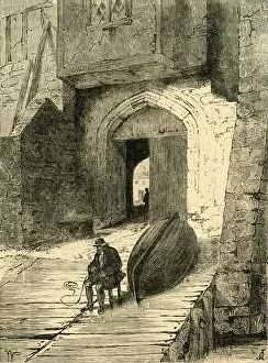
Old Whitehall Stairs, (c1878). Creator: UnknownOld Whitehall Stairs, (c1878). Steps down to the River Thames in London. From Old and New London: A Narrative of Its History, Its People, And Its Places
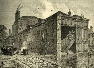
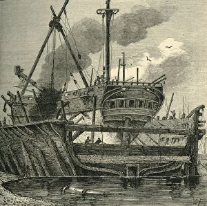
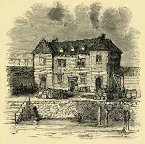
Searles Boat-Yard in 1830, (c1878). Creator: UnknownSearles Boat-Yard in 1830, (c1878). A City barge being repaired at Searles boatyard in Lambeth, south London. From Old and New London: A Narrative of Its History, Its People, And Its Places
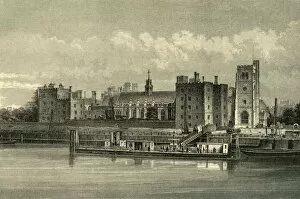
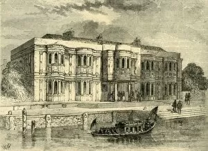
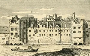
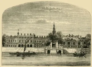
Lambeth Palace, (c1878). Creator: UnknownLambeth Palace, (c1878). View of Lambeth Palace, the church of St Mary-at-Lambeth, and pier on the River Thames. The Palace, on the south bank of the Thames in London
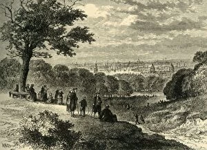
View from One-Tree Hill, Greenwich Park, in 1846, (c1878). Creator: UnknownView from One-Tree Hill, Greenwich Park, in 1846, (c1878). People enjoying the view of the River Thames and the City from a hill in Greenwich Park in what is now south-east London
Crown and Sceptre Inn, Greenwich, (c1878). Creator: UnknownCrown and Sceptre Inn, Greenwich, (c1878). Public house on the River Thames at Greenwich, now part of south London. In the foreground are two Greenwich Pensioners
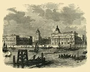
Greenwich Hospital, from the River, (c1878). Creator: UnknownGreenwich Hospital, from the River, (c1878). The Royal Hospital for Seamen at Greenwich, on the River Thames in London, was designed by Sir Christopher Wren and his assistant Nicholas Hawksmoor
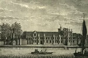
A View of the Ancient Royal Palace Called Placentia, (c1878). Creator: UnknownA View of the Ancient Royal Palace Called Placentia, (c1878). The Palace of Placentia was a palace built on the banks of the Thames at Greenwich by Humphrey, Duke of Gloucester in 1447
Placentia, 1560, (c1878). Creator: UnknownPlacentia, 1560, (c1878). The Palace of Placentia was a palace built on the banks of the Thames at Greenwich by Humphrey, Duke of Gloucester in 1447
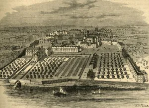
Floating Dock, Deptford (1820), (c1878). Creator: UnknownFloating Dock, Deptford (1820), (c1878). The Royal Navy Dockyard at Deptford on the River Thames operated from the mid-16th to the late 19th century
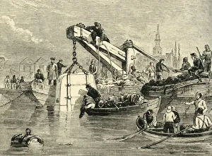
Diving-Bell Used in the Construction of the Thames Tunnel, (c1878). Creator: UnknownDiving-Bell Used in the Construction of the Thames Tunnel, (c1878). Diving bell being used to plug a hole in the bottom of the River Thames
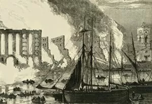
The Great Fire at Cottons Wharf Tooley Street, 1861, (c1878). Creator: UnknownThe Great Fire at Cottons Wharf Tooley Street, 1861, (c1878). Depiction of the Tooley Street fire at Cottons Wharf on the south bank of the River Thames in Bermondsey, London
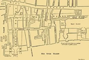
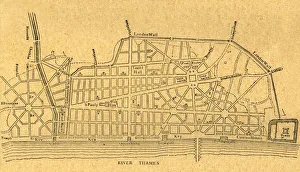
Plan of a Portion of Westminster Between 1734 and 1748 - Before the Erection of Parliament Street, (1881). Map of the area around the Houses of Parliament in London, showing New Palace Yard
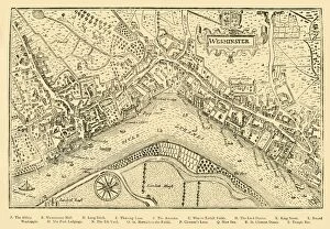
Plan of Westminster. (From Nordens Survey, taken in Queen Elizabeths Reign, 1593), (1881). Birds eye view, by cartographer John Norden (c1547-1625), of the village of Westminster on the River Thames
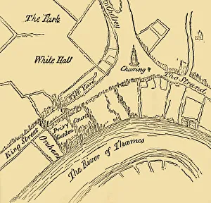
Whitehall in the Reign of Henry VIII, (1881). Creator: UnknownWhitehall in the Reign of Henry VIII, (1881). Map showing the Palace of Whitehall in the village of Westminster (now part of London), in the 16th century
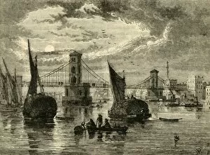
Hungerford Suspension Bridge, 1850, (1881). Creator: UnknownHungerford Suspension Bridge, 1850, (1881). View of the bridge and boats on the River Thames in London, with Nelsons Column in the distance
The Savoy in 1650, (1881). Creator: UnknownThe Savoy in 1650, (1881). The Savoy Palace was built on the banks of the River Thames in the 13th century. In the 14th century it was the London home of John of Gaunt
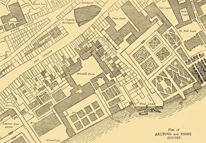
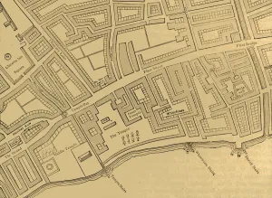
Plan of Arundel and Essex Houses, (1881). Creator: UnknownPlan of Arundel and Essex Houses, (1881). In the Middle Ages Arundel House was the town house of the Bishops of Bath and Wells
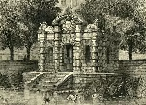
Buckingham Gate in 1830, (1881). Creator: UnknownBuckingham Gate in 1830, (1881). Buckingham Gate, also known as the York Watergate, was built in 1626 and gave access to the River Thames from York House, a mansion on the Strand in London
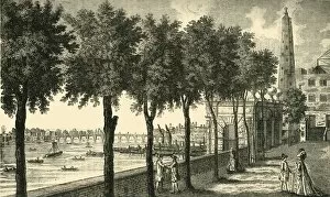
York Stairs and the Water Tower, (1881). Creator: UnknownYork Stairs and the Water Tower, (1881). 18th-century view of York Watergate, Buckingham Street, Westminster, London. Built in 1626 by Nicholas Stone (1586-1647)
Somerset House and Stairs, (1881). Creator: UnknownSomerset House and Stairs, (1881). View of Somerset House, on the north bank of the River Thames in London, with steps down to the river
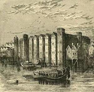
Hall of Winchester House, (c1878). Creator: UnknownHall of Winchester House, (c1878). Winchester Palace on the south bank of the River Thames, (now south London), was the seat of the bishops of Winchester. The great hall was built in c1136
South End of Old London Bridge, with Shot Tower and St. Olaves Church, in 1820, (c1878). View of the south bank of the River Thames in London showing the shot tower (later burned down)
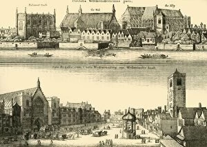
Two Views of Westminster, (1881). Creator: UnknownTwo Views of Westminster, (1881). The village of Westminster, now part of greater London, and the River Thames. Landmarks and buildings shown include: Parliament House, Westminster Hall
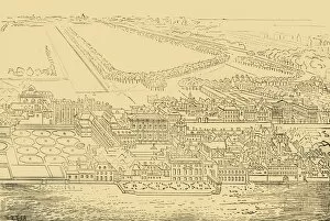
Whitehall and Westminster. (From Aggas Map), (1881). Creator: UnknownWhitehall and Westminster. (From Aggas Map), (1881). Birds eye view, by cartographer Ralph Agas (c1540-1621), of Whitehall Palace in the village of Westminster on the River Thames
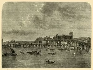
Westminster Bridge, (1881). Creator: UnknownWestminster Bridge, (1881). Bridge across the River Thames at Westminster in London, with the Abbey on the right. From Old and New London: A Narrative of Its History, Its People, and Its Places
Whitehall, from the River, (1881). Creator: UnknownWhitehall, from the River, (1881). The Palace of Whitehall at Westminster, then a village outside London, was the main residence of the English monarchs from 1530 until 1698
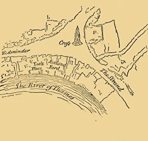
York Place, (1881). Creator: UnknownYork Place, (1881). Map of a part of Westminster in London, showing York Place, Scotland Yard, the Eleanor Cross, The Strand and the River Thames
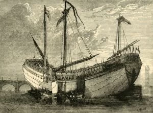
The Chinese Junk, (1881). Creator: UnknownThe Chinese Junk, (1881). The Keying was the first Chinese junk to travel from China to Europe. She sailed from China around the Cape of Good Hope to the United States and Britain between 1846
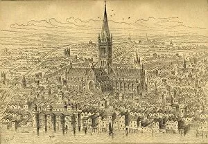
St. Pauls and Neighbourhood, (1897). Creator: UnknownSt. Pauls and Neighbourhood, (1897). Map based on Aggass plan of 1563, showing St Pauls Cathedral in the City of London. Also marked are the old city walls and Ludgate
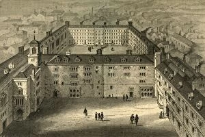
Bridewell as Rebuilt after the Fire, from an old print, (1897). Creator: UnknownBridewell as Rebuilt after the Fire, from an old print, (1897). View of Bridewell as it was during the 18th century. Bridewell Palace
The Custom House - Time of Elizabeth, (c1872). Creator: UnknownThe Custom House - Time of Elizabeth, (c1872). The Custom House in the City of London, depicted during the reign of Queen Elizabeth I (1558-1603). From Old and New London, Vol
The Temple in 1671. (From an old bird s-eye view in the inner temple), (1897). View showing the buildings and gardens at the Inns of Court known as Temple, one of the main legal districts in London
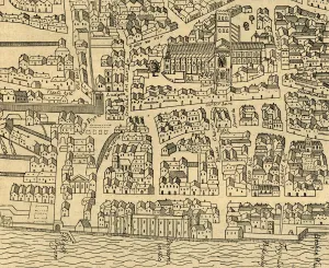
Fleet Street, The Temple, Etc. (1897). Creator: UnknownFleet Street, The Temple, Etc. (1897). Map showing London as it was in the 16th century or so. On the right is Bridewell, on the banks of the Fleet River between Fleet Street and the River Thames
Tower Street Ward, (c1872). Creator: UnknownTower Street Ward, (c1872). Map dating from 1773, of part of the City of London, showing Custom House and ships on the River Thames. From Old and New London, Vol
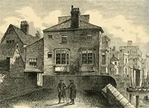
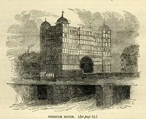
Nonsuch House, (c1872). Creator: UnknownNonsuch House, (c1872). Nonsuch House on old London Bridge was originally constructed in the Netherlands, taken apart and shipped to London in pieces in 1578
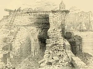
Remains of the Chapel of St. Thomas, Old London Bridge, (c1872). Creator: UnknownRemains of the Chapel of St. Thomas, Old London Bridge, (c1872). The Chapel of St Thomas on the Bridge was built in 1209. In 1548, during the Reformation
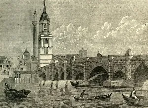
London Bridge, c1872. Creator: UnknownLondon Bridge, c1872. View of the Church of St Magnus the Martyr and the Monument in the City of London. The new bridge over the River Thames was opened in 1831. From Old and New London, Vol
The City of London, c1872. Creator: UnknownThe City of London, c1872. View of the Embankment and the River Thames, Blackfriars road and railway bridges, with St Pauls Cathedral in the distance
Wrens Plan for Rebuilding London, (1897). Creator: UnknownWrens Plan for Rebuilding London, (1897). After the Great Fire of London in 1666, Christopher Wren was among several people to draw up plans for a new capital city
Baynards Castle, from a view published in 1790, (1897). Creator: UnknownBaynards Castle, from a view published in 1790, (1897). Baynards Castle refers to buildings on two neighbouring sites fronting the River Thames in the City of London
Fleet Street, The Temple, Etc. From a Map of London, Published 1720, (1897). Map showing the Inns of Court at Temple and Lincolns Inn, Whitefriars, the River Fleet, Bridewell
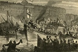
Lord Mayors Water Procession, 1897. Creator: UnknownLord Mayors Water Procession, 1897. Barges of the various livery companies on the River Thames in the City of London. From Old and New London, Volume I, by Walter Thornbury
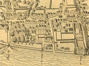
St. Pauls and the Neighbourhood in 1540, (1897). Creator: UnknownSt. Pauls and the Neighbourhood in 1540, (1897). This view shows London as it would have been in the 16th century; the medieval cathedral of St Pauls surrounded by fields
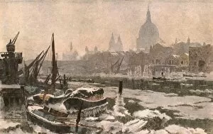
The Thames: A Severe Winter, (c1900). Creator: UnknownThe Thames: A Severe Winter, (c1900). Ice-covered boats on the River Thames in London, with St Pauls Cathedral in the distance. Print after a late-19th century painting by Herbert Menzies Marshall
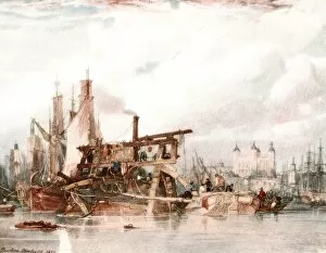
The Tower of London, c1827, (c1900). Creator: UnknownThe Tower of London, c1827, (c1900). A steam-powered ballast dredger on the River Thames in London, with the Tower of London in distance. Print after a painting by Clarkson Stanfield
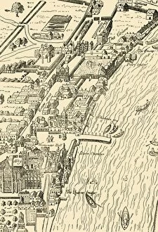
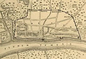
Plan of Roman London, (1897). Creator: UnknownPlan of Roman London, (1897). Map showing the area of what is now the City of London, as it might have looked during the Roman period