mail_outline sales@mediastorehouse.com
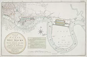
Proposed canals and docks, London, 1800. Plan of a proposed canal and wet docks for the Isle of Dogs, to aid West India trade
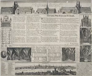
St Pauls Cathedral, City of London, 1725. Artist: David LogganSt Pauls Cathedral, City of London, 1725. Composite image containing exterior and interior views of old and new St Pauls Cathedral
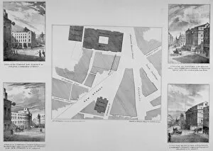
Plan of proposals for King William Street, City of London, 1832. Artist: BladesPlan of proposals for King William Street, City of London, 1832. Showing the streets relationship with the surrounding area. Also incorporating four views of how it would appear
Church of St Mary le Bow, City of London, 1850. Artist: John Le KeuxChurch of St Mary le Bow, City of London, 1850. Section, north elevation and plans of St Mary le Bows steeple designed by Sir Christopher Wren; the elevation also shows figures below on Cheapside
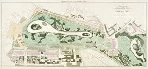
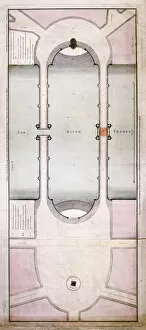
Plan of St Jamess Park, Westminster, London, 1710
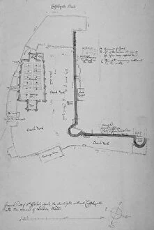
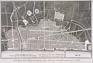
Church of St Giles without Cripplegate, City of London, 1779. Artist: John CarterChurch of St Giles without Cripplegate, City of London, 1779. Plan showing St Giles without Cripplegate, the churchyard and the remains of London Wall
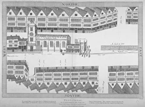
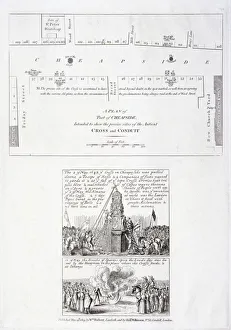
Cheapside, City of London, 1585 (1814). Artist: Bartholomew HowlettCheapside, City of London, 1585 (1814). Plan of Cheapside or Westcheap, as it appeared in 1585; showing houses, St Michael le Querne and the Little Conduit
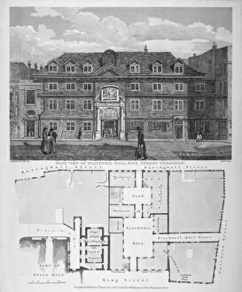
Blackwell Hall, King Street, City of London, 1820. West view of Blackwell Hall, with figures and a plan including part of the Guildhall, Basinghall Street, Cateaton Street
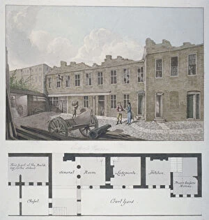
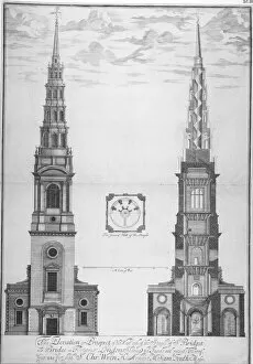
Ludgate Prison with a plan of the London Workhouse, Bishopsgate, beneath, City of London, 1818
St Brides Church, Fleet Street, City of London, 1700. Elevation, section and ground plan of the west end of St Brides steeple
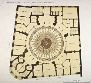
Ground plan of the New Coal Exchange in Lower Thames Street, City of London, 1849. The building was opened by Prince Albert in 1849
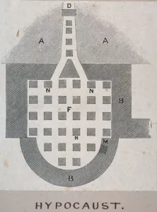
Plan of a Roman hypocaust found on the site of the Coal Exchange, City of London, 1848
Section, elevation and ground plan of St Brides Church, Fleet Street, City of London, 1840. Built in 1672, St Brides is one of Christopher Wrens churches built to replace those destroyed by the Great
Two views of the tower of St Antholin, City of London, 1875; one of the tower erected in 1685, the other of a design of 1875. Between the two is a plan of the church
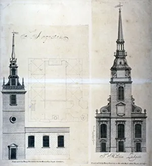
Elevation and plan of St Augustine, Watling Street, City of London, 1740. ArtistElevation and plan of St Augustine, Watling Street, City of London, 1740. Shown next to elevation of St Martin within Ludgate, City of London
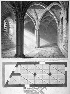
St Michaels Crypt, Aldgate, London, 1816. Artist: William WiseSt Michaels Crypt, Aldgate, London, 1816. Interior view of St Michaels Crypt, Aldgate Street, including an illustration of the groined arches and a street plan
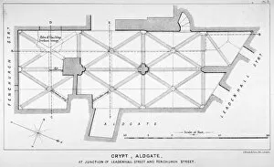
Plan of the groining for St Michaels Crypt, Aldgate Street, London, c1830(?). ArtistPlan of the groining for St Michaels Crypt, Aldgate Street, London, c1830(?)
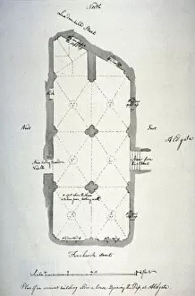
Plan of vaulting in St Michaels Crypt, Aldgate, London, 1784. Artist: John CarterPlan of vaulting in St Michaels Crypt, Aldgate, London, 1784. Plan of vaulting in St Michaels Crypt, Aldgate Street
Plan of tenements in Addle Street, Aldermanbury and Philip Lane, London, c1666. Tenements held in lease by the Brewers Company
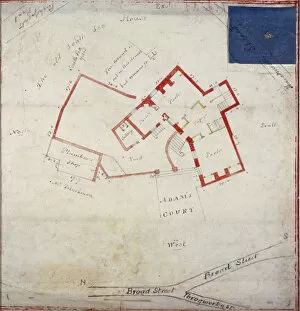
Plan of premises in Adams Court off Old Broad Street, London, c1800
Proposed plan for the rebuilding of the City of London after the Great Fire in 1666
The destruction of the Cheapside Cross, London, 1809. The middle image of three, showing the destruction of the Cheapside Cross in 1643, with a description
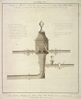
Elevation plan of a receiver and distributor at the London Bridge Waterworks, 1780 (1788)Elevation plan of a receiver and distributor at the London Bridge Waterworks, Southwark, London, 1780 (1788)
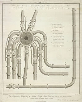
Plan of a receiver and distributor at the London Bridge Waterworks, 1780 (1788). ArtistPlan of a receiver and distributor with pipes from several mains, on each of which there is a communicating cock together with the leading pipe from a fire engine
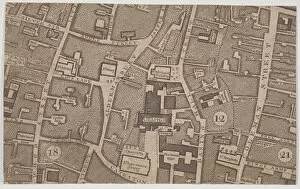
Plan of Guildhall and the neighbourhood around Guildhall, London, 1747
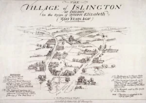
Islington, London, c1860; bird s-eye view of the village of Islington in the reign of Queen Elizabeth I
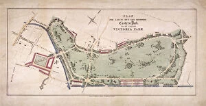
Proposed plan for Victoria Park, Hackney, London, c1845
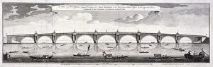
Design for Blackfriars Bridge, London, 1760. Artist: Robert Mylne IIDesign for Blackfriars Bridge, London, 1760. Robert Mylnes accepted design for Blackfriars Bridge, London with barges on the River Thames
New Royal Exchange, City of London, 1839. View showing an alteration to the west front of design no 43 for the new Royal Exchange. Also showing figures and adjacent buildings. Below is a ground plan
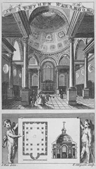
Church of St Stephen Walbrook, City of London, 1770. Artist: Edward RookerChurch of St Stephen Walbrook, City of London, 1770. The top image is an interior view of St Stephen Walbrook with figures; the bottom image is a ground plan
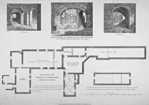
Plan and two views of the Crosby Hall vaults at no 36 Bishopsgate, City of London, 1816. The third central view shows the east entrance of Crosby Square from St Helens
Royal Exchange, London, 1838Design for the new Royal Exchange by JB Bunning, following the destruction of the previous building by fire in 1838
Map of LondonUpper panel shows the City of London from Southwark before the Great Fire of London in 1666; middle panel shows the same view after the Great Fire
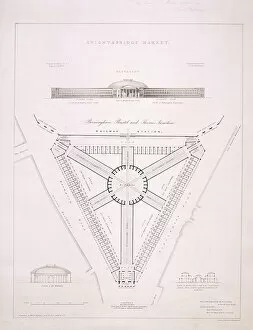
Design for Knightsbridge Market, London, c1840. Artist: JR JobbinsDesign for Knightsbridge Market, at the junction of Brompton Road and Knightsbridge, London, c1840. At the top is an elevation view of the building, with two section views in the bottom corners
Summer Fashions for 1844 ; view of figures in Surrey Gardens, Southwark, London. The background consists of a scene in the Surrey Zoological Gardens and features the lake
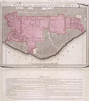
Plan for the proposed London Docks, Stepney, 1799, with text in the lower margin
Plan and longitudinal section of the Thames Tunnel, London, 1842. The Thames Tunnel, connecting Wapping and Rotherhithe, was the first underwater tunnel in the world
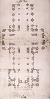
Plan of St Pauls Cathedral, London, 1758. Artist: John GwynPlan of St Pauls Cathedral, London, 1758
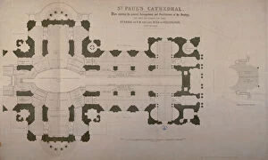
Plan of seating arrangements for the Duke of Wellingtons funeral, 1852Plan showing the seating arrangements for the funeral of the Duke of Wellington, 1852 in St Pauls Cathedral, London
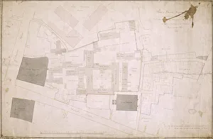
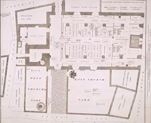
Plan of Christs Hospital, Newgate Street, London and its adjoining estate, 1819. The individual buildings are identified
Plan of the shop fronts on Old and New Bond Street, London, c1838. Several of the buildings are named and the streets leading off Old and New Bond Street are identified
Plan of part of Christs Hospital, Newgate Street and St Bartolomews Hospital, London, 1818Plan of part of Christs Hospital, Newgate Street, London and part of St Bartholomews Hospital, London, 1818, showing the proposed line of division between them
Plan of the Church of St Peter upon Cornhill, London, 1815, including its cemetery and identifying surrounding streets
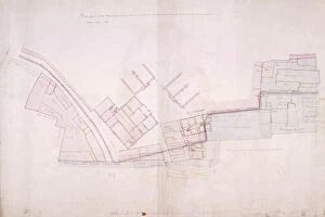
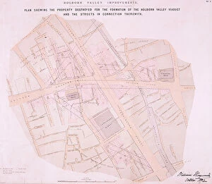
Holborn Viaduct, London, 1869. Artist: William HaywoodHolborn Viaduct, London, 1869. Plan showing the demolitions undertaken for Holborn Viaduct over the Fleet Valley
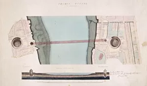
Plan of the old and new London Bridge, 1800
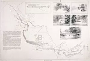
A plan of Hyde Park, Green Park and St Jamess Park, c1827. Showing the proposed canal, together with insets depicting views in the parks after the improvements have been completed
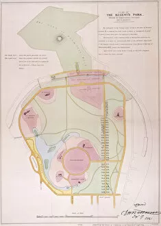
Plan of Regents Park, 1841. Showing the sites for twenty six villas to be built within the parks area and some surrounding streets
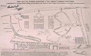
Plan of Hyde Park, 1867. Plan showing the intended alterations in The Peoples (formerly Hyde ) Park. A comment on Beales and the Reform League, who in 1867 attempted to hold a meeting in the park