mail_outline sales@mediastorehouse.com
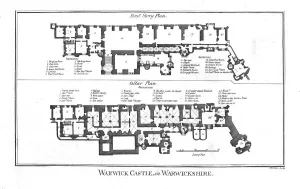
Warwick Castle, in Warwickshire. late 18th century. Artist: ThorntonWarwick Castle, in Warwickshire. late 18th century. Plan of the castle which was first fortified in c915. William I ordered the castle to be extended in 1086
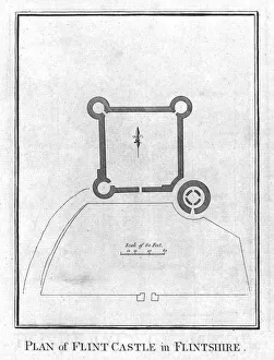
Plan of Flint Castle in Flintshire. c1800. Flint Castle, on the north-east coast of Wales, dates from 1277. Its single Donjon tower, (bottom right), isolated from the rest of the inner ward
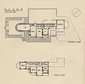
House at Burn Bridge by The Late John Procter, F. R. I. B. A. 1942House at Burn Bridge by The Late John Procter, F.R.I.B.A. - Plan, 1942. Situated above a wooded valley in Yorkshire. Plan of Ground Floor and First Floor
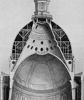
A sectional drawing of Sir Christopher Wrens great dome, c1934A sectional drawing of Sir Christopher Wrens great dome, showing how the stone lantern with its ball and cross are supported on a conical wall built between the outer and inner domes, c1934
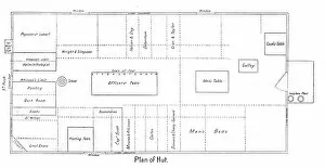
Plan of Hut, c1910–1913, (1913)Plan of Hut, c1910– 1913, (1913). Diagram showing that class distinctions were still maintained despite the difficult conditions, with separate officers and mens quarters
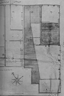
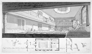
Ground Plan of Lloyds Coffee House (No. 16 Lombard Street) in 1773, (1928)Ground Plan of Lloyds Coffee House (No. 16 Lombard Street) in 1773, 1928. From A History of Lloyd s, by Charles Wright and C. Ernest Fayle. [Macmillan and Company Limited, London, 1928]
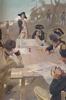
Bonaparte Explaining His Plan for the Taking of Toulon, 1793, (1896). Typogravure after the painting by Andre Castaigne. From Life of Napoleon Bonaparte, Volume I, by William Milligan Sloane
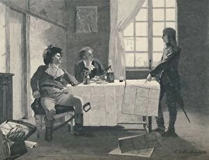
Bonaparte, Turreau, and Volney at Nice in 1793, (1896). Artist: E. G. H. Del OrmeBonaparte, Turreau, and Volney at Nice in 1793, (1896). Bonaparte laid before the others the plan of campaign in Italy which he executed as general in chief, three years later
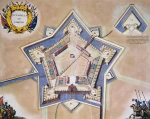
Plan of the citadel of Turin in 1664
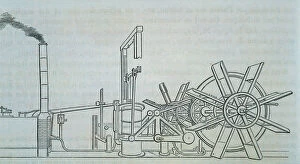
Plan and perspective of the steam engine and wheels tree of the Clermont ship, built by Robert Fulton in 1807
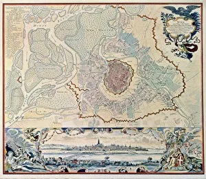
Plan of the city of Vienna following an engraving of 1720
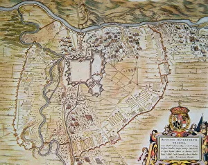
Plan of the citadel of Turin during the siege of 1640
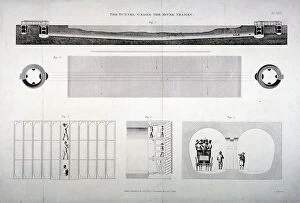
Plan, sections and elevations of the Thames Tunnel, London, 1835. Artist: E TurrellPlan, sections and elevations of the Thames Tunnel, London, 1835. The Thames Tunnel, connecting Wapping and Rotherhithe, was the first underwater tunnel in the world
Plan of a proposal to construct a dock on the site of St Katharines Hospital, London, c1825. St Katharines Dock opened in October 1828
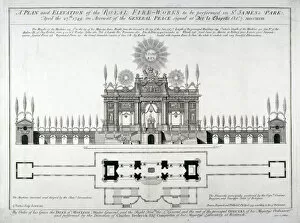
Plan and elevation of the royal fireworks to be performed in St Jamess Park, London, 1749. The display, held on 27 April 1749, was to celebrate the end of the War of the Austrian Succession
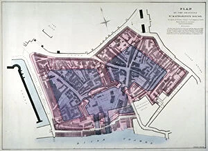
Ground plan of St Bartholomews Priory, Smithfield, City of London, 1821Ground plan of St Bartholomews Priory, Smithfield and vicinity. Also shown is the conventual seal and a key
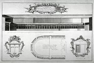
Windsor Castle, Berkshire, c1740. Elevation and plan of the Canons Cloisters and details of two doors
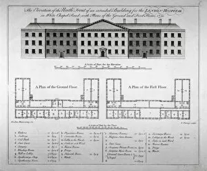
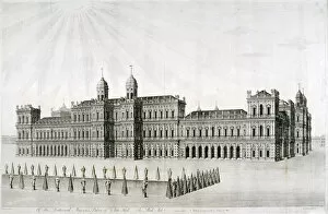
Elevation of the north front and plans of London Hospital, Whitechapel, London, 1752. The hospital, which was founded in 1740, moved into this building in 1757
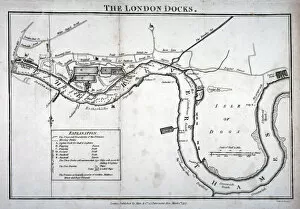
Plan of the River Thames showing the London Docks and the Isle of Dogs, 1797
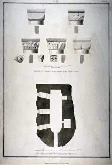
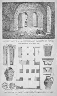
Plan of the cells under the chapel of the White Tower, Tower of London, 1815. ArtistPlan of the cells under the chapel of the White Tower, Tower of London, 1815. Above are details and sections of column capitals
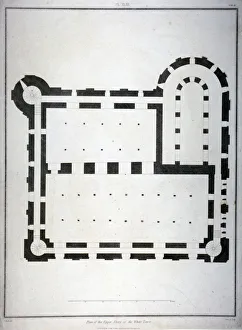
Plan of the upper storey of the White Tower, Tower of London, 1815. Work on the White Tower probably began in around 1077 after William the Conqueror, having occupied London
Elevation of proposed houses in Victoria Street, Westminster, London, c1845. ArtistElevation of proposed houses in Victoria Street, Westminster, London, c1845
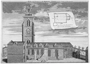
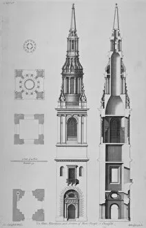
Church of St Martin-in-the-Fields, Westminster, London, c1720. Artist: George VertueChurch of St Martin-in-the-Fields, Westminster, London, c1720. View looking north, with a plan in the sky to the right. Designed by James Gibbs, the church was built in the 1720s
View of Queens Gate, Hyde Park, Kensington, London, 1857. Artist: Day & SonView of Queens Gate, Hyde Park, Kensington, London, 1857
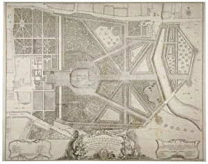
Plan of Kensington Palace and gardens, London, 1736. The gardens were laid out between 1728 and 1738 by Henry Wise and Charles Bridgeman for Queen Caroline
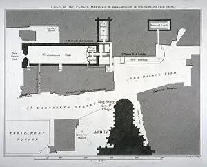
Plan of the public offices and buildings at Westminster, London, 1810
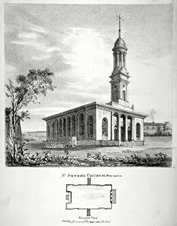
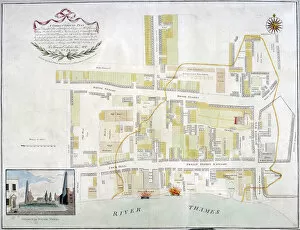
View and ground plan of the Church of St Peter Newington, Southwark, London, 1824
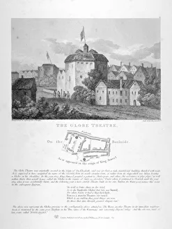
The Globe Theatre, Bankside, Southwark, London, 1810. View with a plan of surrounding streets and a description beneath
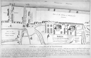
Plan of Bankside, Southwark, London, c1570. Showing the arenas for bull and bear baiting, the pike gardens and Winchester Park
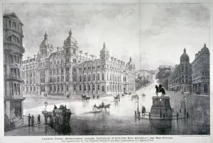
View of an improvement scheme for the area around Charing Cross, Westminster, London, c1860
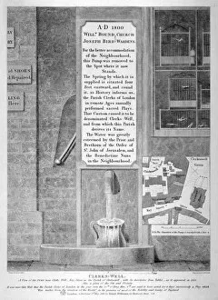
View of the pump near Clerks Well in Ray Street, Finsbury, London, 1822. ArtistView of the pump near Clerks Well in Ray Street, Finsbury, London, 1822. Above the pump is a descriptive iron tablet accompanied by a plan of the site; in the upper left a collection of caged birds
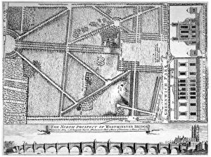
Plan of Greenwich Park, Greenwich, London, 1749. With a south view of the Rangers House or Queens House, a north view of Flamsteed House, and the north prospect of Westminster Bridge in the margins
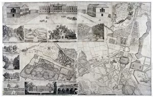
Plan and views of Wanstead House and Park in the borough of Redbridge, London, 1735
Inigo Joness intended Whitehall Palace, London, 1749. Artist: DM MullerInigo Joness intended Whitehall Palace, London, 1749. View showing the palace, designed in 1638, as it would have appeared from St Jamess Park
Plan of the fire that took place at Ratcliff in Stepney, London, in 1794. ArtistPlan of the fire that took place at Ratcliff in Stepney, London, in 1794. The area was devastated by the worst of many fires which constantly swept through the riverside hamlet
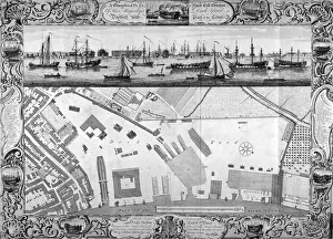
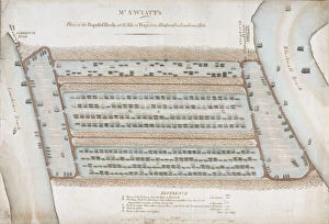
Deptford Docks, London, 1753. ArtistDeptford Docks, London, 1753. Plan of the Dock Yard at Deptford including the surrounding area. In the upper section is a view of the River Thames with water vessels
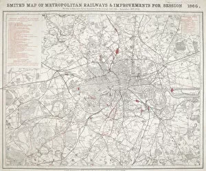
Map of Greater London showing the Metropolitan Railways and improvements in 1866. With a table inset listing the proposed lines
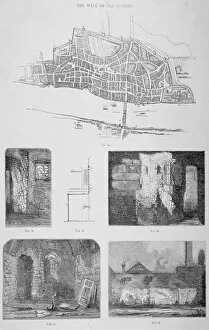
Wall of London, 1820. Plan showing the wall of London with five images of the wall below
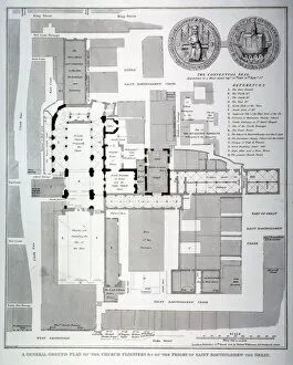
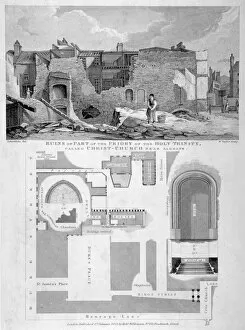
Holy Trinity Priory, City of London, 1826. ArtistHoly Trinity Priory, City of London, 1826. Composite image showing the ruins of the Priory of Holy Trinity, Aldgate, at the top with a plan of the vicinity beneath
Three Cranes Lane Chapel, Upper Thames Street, City of London, 1818. Plan, flanked by building details, surmounted by an interior view of the chapel with two women cleaning it
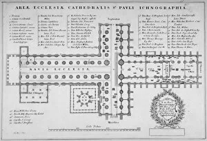
Plan of the old St Pauls Cathedral, City of London, 1657. Artist: J HarrisPlan of the old St Pauls Cathedral, City of London, 1657
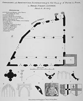
Iconography, architectural details and sections of the Church of St Peter-le-Poer, London, 1807Iconography, architectural details and sections of the Church of St Peter-le-Poer, City of London, 1807
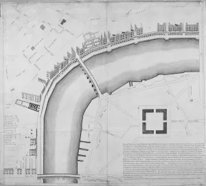
Proposed Thames embankment, London, 1760. ArtistProposed Thames embankment, London, 1760. An embankment from Westminster Bridge to Blackfriars proposed by John Lacy. The scheme would have provided a continuous quay
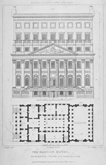
Mansion House, City of London, 1826. Artist: George GladwinMansion House, City of London, 1826. Elevation of Mansion Houses front with a ground plan below
Interior view of the remains of the Church of St Martins le Grand, City of London, 1825. With details and ground plan underneath
Plans, elevations and section of the Church of St Mary-le-Bow, Cheapside, City of London, 1725
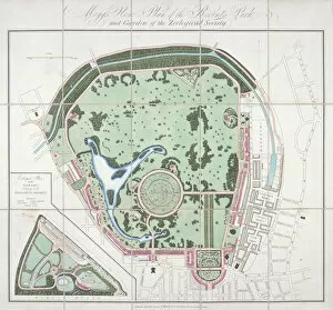
Plan of the Zoological Gardens, Regents Park, St Marylebone, London, 1828. ArtistPlan of the Zoological Gardens, Regents Park, St Marylebone, London, 1828
Plan of proposed docks at the Isle of Dogs, now the site of West India Docks, London, 1820