mail_outline sales@mediastorehouse.com
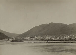
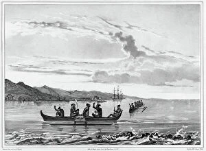
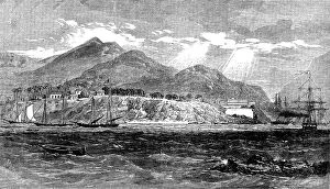
General View of Petropavlovsk, 1889. Creator: UnknownGeneral View of Petropavlovsk, 1889. From a collection consisting of an album and individual photographs that document the Arctic voyage in 1889 of the clipper ship Razboinik (Pirate)
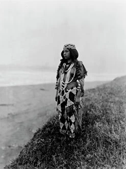
On the shores of the Pacific-Tolowa, c1923. Creator: Edward Sheriff CurtisOn the shores of the Pacific-Tolowa, c1923. Dorothy Lopez Williams standing on hillside looking out over the Pacific Ocean
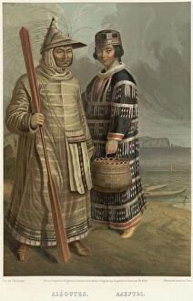
Aleuts, 1862. Creator: Karlis HunsAleuts, 1862. Sheet 61 from the album "Description ethnographique des peuples de la Russie", volume 1. Description ethnographique des peuples de la Russie
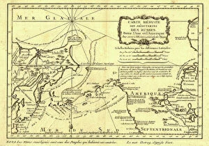
Carte re´duite des de´couvertes des Russes, entre l'Asie et l'Amerique, (1747?). This French map of Alaska, Siberia, and the North Pacific, published in 1747
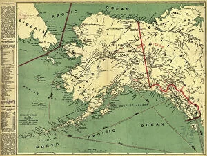
Millroy's map of Alaska and the Klondyke gold fields, 1897. Creator: J. J. MillroyMillroy's map of Alaska and the Klondyke gold fields, 1897. The Klondike Gold Rush of 1898 began in earnest within 18 months of a major gold strike on Bonanza Creek
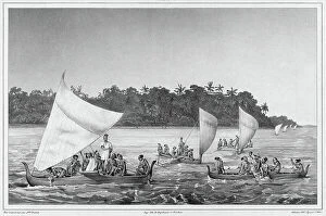
Navigation, Lower Caroline Islands, Lukunor Group, 19th century. Creators: Alexander Postels, Victor AdamNavigation, Lower Caroline Islands, Lukunor Group, 19th century. One of 65 lithographs that were included in the volume of maps published after the round-the-world voyage of the corvette Seniavin
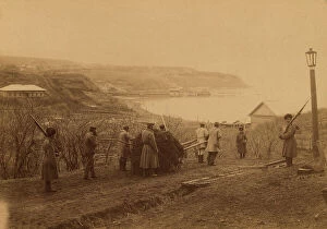
Exiled Captives Carting Manure at Korsakov Post in Southern Sakhalin, 1880-1899. From an album created on Sakhalin Island in the 1890s
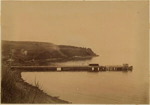
The Gulf of Aniva The Wharf at the Korsakov Prison, 1880-1899. Creator: Innokenty Ignatievich PavlovskyThe Gulf of Aniva The Wharf at the Korsakov Prison, 1880-1899. From an album created on Sakhalin Island in the 1890s. Sakhalin was used by imperial Russia as a penal colony
View of the Port of La Coquille In Kosrae Island, Caroline Islands, 19th century. One of 65 lithographs that were included in the volume of maps published after the round-the-world voyage of
Map of the United States, the British provinces, Mexico &c. 1849. Creator: John M. AtwoodMap of the United States, the British provinces, Mexico &c. 1849. Shows California's gold region and western trails. Includes illustration of "Pyramid Lake
The Alaska Line, 1934. Creator: Alaska Steamship CoThe Alaska Line, 1934. This map, published in 1934 for the tourist market with colorful images and motifs, shows various shipping routes of the Alaska Line
Due Coal Mine Alekseevsky Drift, 1880-1899. Creator: Innokenty Ignatievich PavlovskyDue Coal Mine Alekseevsky Drift, 1880-1899. From an album created on Sakhalin Island in the 1890s. Sakhalin was used by imperial Russia as a penal colony and place of exile for criminals
View of Auckland Harbour, New Zealand...the race of the Maori war-canoes, 1862. Creator: UnknownView of Auckland Harbour, New Zealand, from a drawing by Major Stack, taken during the regatta of January, 1862: the race of the Maori war-canoes, 1862
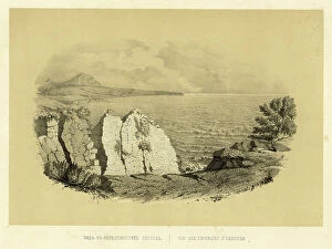
View of the entrance to Avacha Bay, taken from Starichkov Island, 19th century. One of 65 lithographs that were included in the volume of maps published after the round-the-world voyage of
Town and port of Acapulco, on the west coast of Mexico, with the English and French squadron...1862 Creator: UnknownTown and port of Acapulco, on the west coast of Mexico, with the English and French squadron lying in the harbour, 1862. Engraving from a sketch by Mr. Boyle of the Termagant
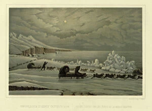
Winter Road Along the Shore of the Sea of Okhotsk, 1856. Creator: Ivan Dem'ianovich BulychevWinter Road Along the Shore of the Sea of Okhotsk, 1856. From Puteshestviye po Vostochnoy Sibiri I. Bulychova. Chast 1-ya
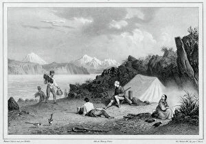
Landscape of the Vicinity of Okhotsk, 1856. Creator: Ivan Dem'ianovich BulychevLandscape of the Vicinity of Okhotsk, 1856. From Puteshestviye po Vostochnoy Sibiri I. Bulychova. Chast 1-ya. Poyezdka v Kamchatku (A journey across eastern Siberia: Part 1, Trip to Kamchatka)
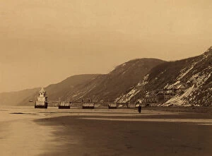
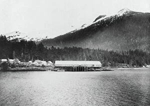
View of Ketchikan, c1899. Creator: UnknownView of Ketchikan, c1899
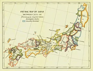
Feudal Map of Japan between 1573 -83, (1903). Creator: UnknownFeudal Map of Japan between 1573 -83, (1903). The feudal period of Japanese history was a time when powerful families (daimyo) and military warlords (shogun) ruled Japan
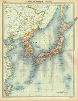
Political map of the Japanese Empire, early 20th century. Korea was under Japanese rule from 1910-1945. Japanese forces invaded and occupied Sakhalin during the Russo-Japanese War in 1905
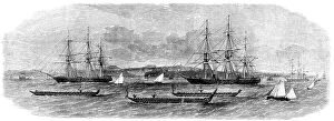
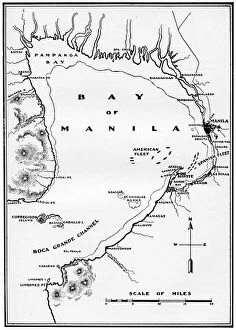
Battle of Manila Bay, Philippines, Spanish-American War, 1898. The battle, the first major engagement of the war, resulted in the destruction of the Spanish Pacific Squadron by the US Navys Asiatic
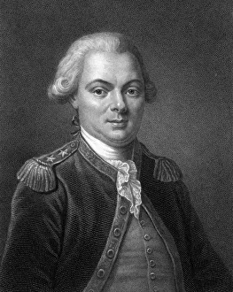
Comte de La Perouse, 18th century French navigator, astronomer and explorer, c1834Jean Francois de Galaup, Comte de La Perouse, 18th century French navigator, astronomer and explorer, c1830. La Perouse (1741-1788) spent four years (1785-1788)
Bay of St. Vincent, New Caledonia; Some Account of New Caledonia, 1875. Creator: UnknownBay of St. Vincent, New Caledonia; Some Account of New Caledonia, 1875. From, Illustrated Travels by H.W. Bates. [Cassell, Petter, and Galpin, c1880, London]
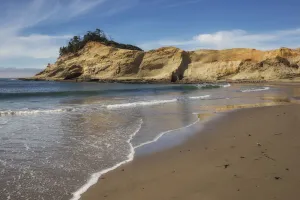
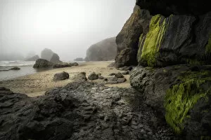
Cape Kiwanda. Creator: Joshua JohnstonCape Kiwanda
Iguana Paradise. Creator: Joshua JohnstonIguana Paradise
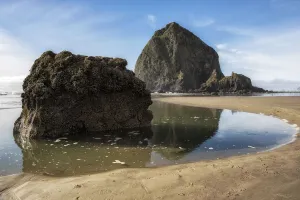
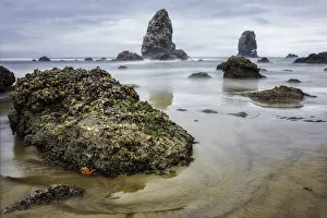
Haystack Rock. Creator: Joshua JohnstonHaystack Rock
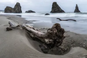
Final Resting Place. Creator: Joshua JohnstonFinal Resting Place
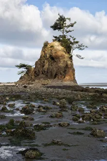
Chief Kiawanda Rock. Creator: Joshua JohnstonChief Kiawanda Rock
What Does a Starfish Dream Of. Creator: Joshua JohnstonWhat Does a Starfish Dream Of
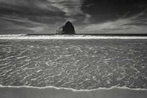
Cannon Beach. Creator: Joshua JohnstonCannon Beach
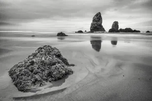
Three Brothers. Creator: Joshua JohnstonThree Brothers
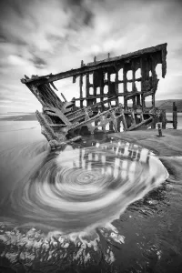
The Vortex of Peter Iredale. Creator: Joshua JohnstonThe Vortex of Peter Iredale
Oregon Coast. Creator: Joshua JohnstonOregon Coast
Apollo 11 Recovery Area, 1969. Creator: NASAApollo 11 Recovery Area, 1969. Pararescueman Lt. Clancy Hatleberg closes the Apollo 11 spacecraft hatch as astronauts Neil Armstrong, Michael Collins, and Buzz Aldrin, Jr
Cooper and Faith 7 recovery, 1963. Creator: NASACooper and Faith 7 recovery, 1963. US Navy divers install a stabilizing flotation collar around Gordon Coopers Mercury space capsule nicknamed " Faith 7" shortly after splashdown
Apollo 13 Recovery Area, 1970. Creator: NASAApollo 13 Recovery Area, 1970. Astronaut John L. Swigert Jr. command module pilot, is lifted aboard a helicopter in a Billy Pugh helicopter rescue net while astronaut James A. Lovell Jr
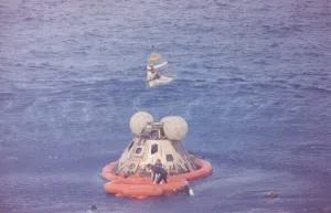
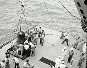
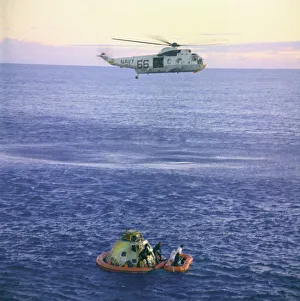
Gordon Cooper and capsule on deck, Pacific Ocean, 1963. Creator: NASAGordon Cooper and capsule on deck, Pacific Ocean, 1963. Recovery personnel bring the Mercury space capsule " Faith 7" onboard the recovery ship U.S.S
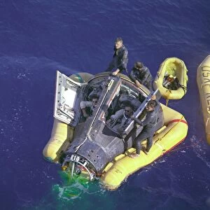
Gemini VIII splashdown, Armstrong and Scott with hatches open, March 16, 1966. Astronauts Neil A. Armstrong and David R. Scott sit with their spacecraft while awaiting the arrival of the recovery
Apollo 17 Pacific Recovery Area, 1972. Creator: NASAApollo 17 Pacific Recovery Area, 1972. The Apollo 17 spacecraft, containing astronauts Eugene A. Cernan, Ronald E. Evans, and Harrison H
Apollo 8 Recovery, 1968. Creator: NASAApollo 8 Recovery, 1968. A team of U.S. Navy underwater demolition swimmers prepares the Apollo 8 command module for being hoisted aboard the carrier U.S.S
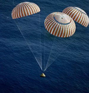
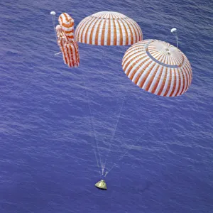
Apollo 17 splashdown, Pacific Ocean, December 19, 1972. Creator: NASAApollo 17 splashdown, Pacific Ocean, December 19, 1972. The Apollo 17 Command Module (CM) " America", with astronauts Eugene A. Cernan, Ronald E. Evans and Harrison H
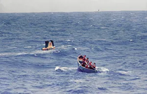
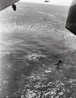
Navy frogmen swim to spacecraft to begin retrieval, Pacific Ocean, 1963. Creator: NASANavy frogmen swim to spacecraft to begin retrieval, Pacific Ocean, 1963. U.S. Navy frogman, deployed from the hovering helicopter, swims next to the spacecraft and makes contact with astronaut L
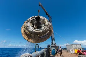
LDSD retrieval, June 28, 2014. Creator: NASALDSD retrieval, June 28, 2014. NASAs Low-Density Supersonic Decelerator (LDSD) is lifted aboard the Kahana recovery vessel. The LDSD launch tested technologies for landing large payloads on Mars
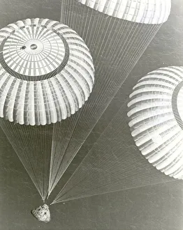
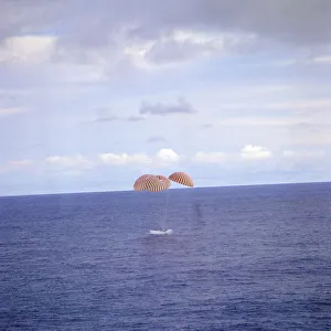
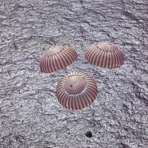
Apollo 13 Splashdown, 1970. Creator: NASAApollo 13 Splashdown, 1970. A perilous space flight comes to a smooth ending with the safe splashdown of the Apollo 13 Command Module (CM) in the south Pacific Ocean
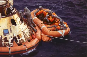
Apollo 11 Crew in Raft before Recovery, 1969. Creator: NASAApollo 11 Crew in Raft before Recovery, 1969. The Apollo 11 crew await pickup by a helicopter from the USS Hornet, prime recovery ship for the historic Apollo 11 lunar landing mission
Endeavour Nears Splashdown, 1971. Creator: NASAEndeavour Nears Splashdown, 1971. The Apollo 15 Command Module " Endeavour", with Astronauts David R. Scott, Alfred M. Worden and James B
Apollo 10 Helicopter Recovery, 1969. Creator: NASAApollo 10 Helicopter Recovery, 1969. A Navy helicopter arrivies to recover the Apollo 10 astronauts, seen entering a life raft
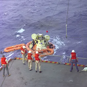
Apollo 16 Recovery, 1972. Creator: NASAApollo 16 Recovery, 1972. The Apollo 16 command module, with astronauts John W. Young, Thomas K. Mattingly II and Charles M. Duke Jr