mail_outline sales@mediastorehouse.com
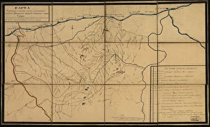
Karta I?A?kutskoi? oblasti chasti Olekminskago okruga i Irkutskoi? guberni¯i? Kirenskogo... 1853. Creator: UnknownKarta I?A?kutskoi? oblasti chasti Olekminskago okruga i Irkutskoi? guberni¯i? Kirenskogo [sic] chast okrugas pokazani¯em zolotosoderzhashchikh pri¯i?skov razrabatyvaemyi?a? : gg
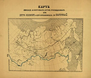
[Karty pochtovykh soobshcheni¯i? uchrezhdennykh v Rossi¯i?skoi? Imperi¯i pri T?S?ari?e... (186-?). Creator: Unknown[Karty pochtovykh soobshcheni¯i? uchrezhdennykh v Rossi¯i?skoi? Imperi¯i pri T?S?ari?e? Aleksi?e?i?e? Mikhailovichi?e? i ego preemnikakh do Ekateriny II], (186-?)
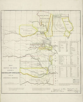
Map showing the lands assigned to emigrant Indians west of Arkansas and Missouri, 1836. Creator: Topographical BureauMap showing the lands assigned to emigrant Indians west of Arkansas and Missouri, 1836. Following passage of the Indian Removal Act in 1830
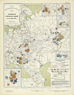
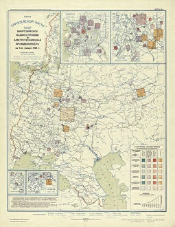
Industry of binding building materials on January 1, 1933, 1934. Creator: Mikhail Alekseevich TSvetkovIndustry of binding building materials on January 1, 1933, 1934. From the atlas "Industry of the USSR at the beginning of the 2nd Five-Year Plan
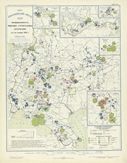
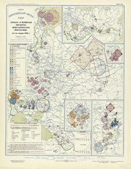
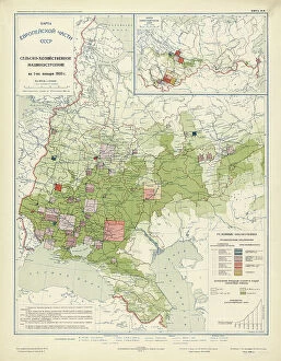
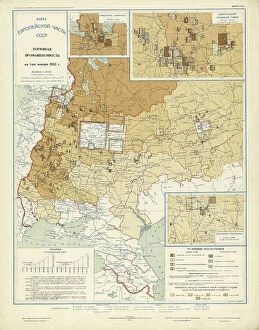
Extraction and primary processing of non-metallic minerals as of January 1, 1933, 1934. From the atlas "Industry of the USSR at the beginning of the 2nd Five-Year Plan
Production of refractory products on January 1, 1933, 1934. Creator: Mikhail Alekseevich TSvetkovProduction of refractory products on January 1, 1933, 1934. From the atlas "Industry of the USSR at the beginning of the 2nd Five-Year Plan
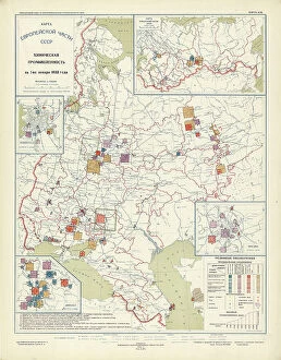
Chemical industry of the USSR on January 1, 1933, 1934. Creator: Mikhail Alekseevich TSvetkovChemical industry of the USSR on January 1, 1933, 1934. From the atlas "Industry of the USSR at the beginning of the 2nd Five-Year Plan
Precision mechanics on January 1, 1933, 1934. Creator: Mikhail Alekseevich TSvetkovPrecision mechanics on January 1, 1933, 1934. From the atlas "Industry of the USSR at the beginning of the 2nd Five-Year Plan
Agricultural engineering as of January 1, 1933, 1934. Creator: Mikhail Alekseevich TSvetkovAgricultural engineering as of January 1, 1933, 1934. From the atlas "Industry of the USSR at the beginning of the 2nd Five-Year Plan
Power engineering and electrical industry as of January 1, 1933, 1934. Creator: Mikhail Alekseevich TSvetkovPower engineering and electrical industry as of January 1, 1933, 1934. From the atlas "Industry of the USSR at the beginning of the 2nd Five-Year Plan
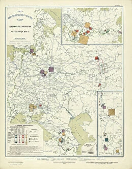
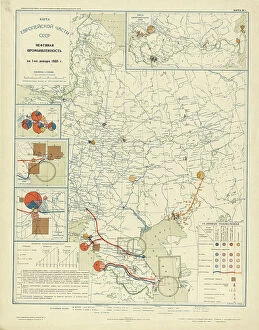
Non-ferrous metallurgy on January 1, 1933, 1934. Creator: Mikhail Alekseevich TSvetkovNon-ferrous metallurgy on January 1, 1933, 1934. From the atlas "Industry of the USSR at the beginning of the 2nd Five-Year Plan
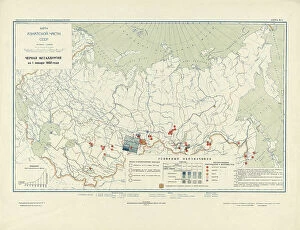
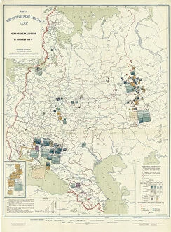
Ferrous metallurgy on January 1, 1933, 1934. Creator: Mikhail Alekseevich TSvetkovFerrous metallurgy on January 1, 1933, 1934. From the atlas "Industry of the USSR at the beginning of the 2nd Five-Year Plan
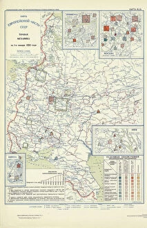
Peat industry on January 1, 1933, 1934. Creator: Mikhail Alekseevich TSvetkovPeat industry on January 1, 1933, 1934. From the atlas "Industry of the USSR at the beginning of the 2nd Five-Year Plan
Oil industry on January 1, 1933, 1934. Creator: Mikhail Alekseevich TSvetkovOil industry on January 1, 1933, 1934. From the atlas "Industry of the USSR at the beginning of the 2nd Five-Year Plan
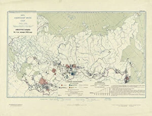
Coal industry on January 1, 1933, 1934. Creator: Mikhail Alekseevich TSvetkovCoal industry on January 1, 1933, 1934. From the atlas "Industry of the USSR at the beginning of the 2nd Five-Year Plan
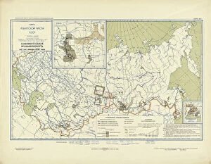
Power plants on January 1, 1933, 1934. Creator: Mikhail Alekseevich TSvetkovPower plants on January 1, 1933, 1934. From the atlas "Industry of the USSR at the beginning of the 2nd Five-Year Plan
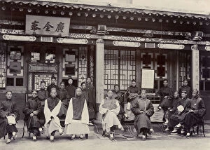
Chinese merchants in Maimachen, 1900. Creator: Nikolai Nikolaevich PetrovChinese merchants in Maimachen, 1900. From a collection of 71 items (photographs and negatives on glass) made in the late 19th century and early 20th century by the famous revolutionary-populist
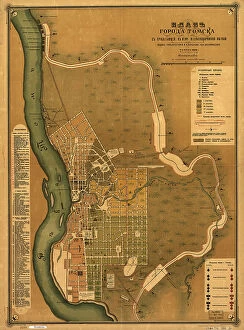
Plan goroda Tomskas prilegai?u?shchei? k nemu zheli?e?znodorozhnoi? vi?e?tv'i?u?, 1898. Creators: M. NPlan goroda Tomskas prilegai?u?shchei? k nemu zheli?e?znodorozhnoi? vi?e?tv'i?u?, 1898. Scale 1:16, 800; Relief shown by land form drawings. Russian. Shows wards and fire districts
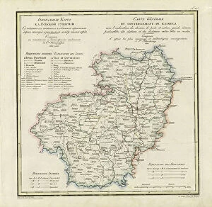
General Map of Kaluga Province: Showing Postal and Major Roads, Stations and... 1822General Map of Kaluga Province: Showing Postal and Major Roads, Stations and the Distance in Versts between Them, 1822. This 1822 map of Kaluga Province is from a larger work
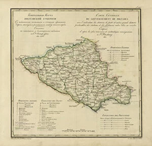
General Map of Poltava Province: Showing Postal and Major Roads, Stations and... 1821General Map of Poltava Province: Showing Postal and Major Roads, Stations and the Distance in Versts between Them, 1821. This 1821 map of Poltava Provinceis from a larger work
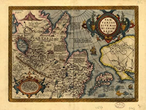
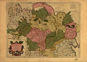
Tartariae sive Magni Chami Regni ty¨pus, 1603. Creators: Abraham Ortelius, Jan Baptist VrientsTartariae sive Magni Chami Regni ty¨pus, 1603. Covers northern Asia. Relief shown pictorially. From Abraham Ortelius's atlas: Theatrvm Orbis Terrarvm, 1603 ed. Hand col
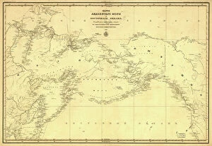
Karta Ledovitago mori?a? i Vostochnago okeana, 1844. Creator: UnknownKarta Ledovitago mori?a? i Vostochnago okeana, 1844. Depths shown by soundings in coastal waters. Also covers Russian Far East and Alaska
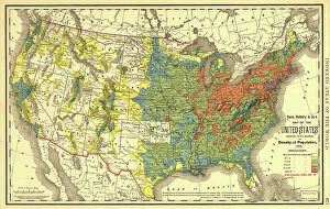
Rand, McNally & Co.'s map of the United States showing, in six degrees the density of pop... 1890Rand, McNally & Co.'s map of the United States showing, in six degrees the density of population, 1890, (1892). This map, published in 1892 by the Chicago-based Rand McNally and Company
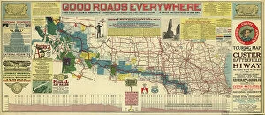
Touring map of the Custer Battlefield Hiway: the scenic route to the west, 1925. Creators: John C. Mulford, C. CTouring map of the Custer Battlefield Hiway: the scenic route to the west, 1925. The Custer Battlefield Highway was created in 1925 as a scenic route between Iowa and Montana
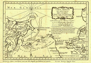
Carte re´duite des de´couvertes des Russes, entre l'Asie et l'Amerique, (1747?). This French map of Alaska, Siberia, and the North Pacific, published in 1747
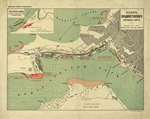
Plan Vladivostokskago torgovago porta, 1916. Creator: Ministerstvo torgovli i promyshlennostiPlan Vladivostokskago torgovago porta, 1916. Karta t?s?vetnai?a?, nakleena na tkan'. Dop. karta: Likhternai?a? gavan na beregu Amurskago zal. u Pervoi? rechki. M. [1:8 400]
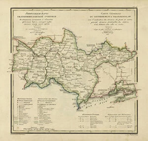
General Map of Ekaterinoslav Province: Showing Postal and Major Roads, Stations and the... 1821General Map of Ekaterinoslav Province: Showing Postal and Major Roads, Stations and the Distance in Versts between Them, 1821
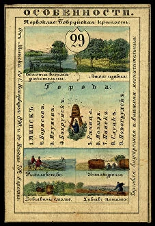
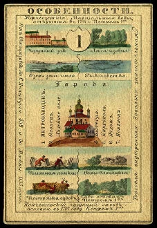
Minsk Province, 1856. Creator: UnknownMinsk Province, 1856. This card is one of a souvenir set of 82 illustrated cards-one for each province of the Russian Empire as it existed in 1856
Millroy's map of Alaska and the Klondyke gold fields, 1897. Creator: J. J. MillroyMillroy's map of Alaska and the Klondyke gold fields, 1897. The Klondike Gold Rush of 1898 began in earnest within 18 months of a major gold strike on Bonanza Creek
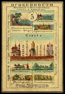
Estland Province, 1856. Creator: UnknownEstland Province, 1856. This card is one of a souvenir set of 82 illustrated cards-one for each province of the Russian Empire as it existed in 1856
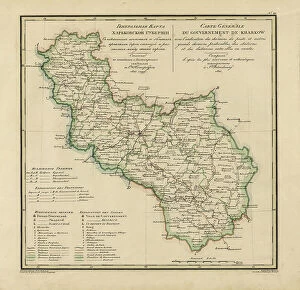
General Map of Kharkiv Province: Showing Postal and Major Roads, Stations and the... 1821General Map of Kharkiv Province: Showing Postal and Major Roads, Stations and the Distance in Versts between Them, 1821. This 1821 map of Kharkiv Provinceis from a larger work
Carte de Tartarie, 1706. Creator: Guillaume DelisleCarte de Tartarie, 1706
General Map of Vladimir Province: Showing Postal and Major Roads, Stations and the... 1822General Map of Vladimir Province: Showing Postal and Major Roads, Stations and the Distance in Versts between Them, 1822. This 1822 map of Vladimir Provinceis from a larger work
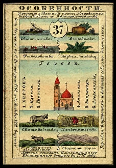
Kherson Province, 1856. Creator: UnknownKherson Province, 1856. This card is one of a souvenir set of 82 illustrated cards-one for each province of the Russian Empire as it existed in 1856
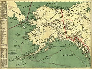
Russian-American possessions, 1856. Creator: UnknownRussian-American possessions, 1856. This card is one of a souvenir set of 82 illustrated cards-one for each province of the Russian Empire as it existed in 1856
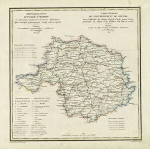
General Map of Kursk Province: Showing Postal and Major Roads, Stations and the... 1822General Map of Kursk Province: Showing Postal and Major Roads, Stations and the Distance in Versts between Them, 1822. This 1822 map of Kursk Provinceis from a larger work
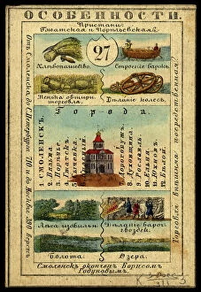
Smolensk Province, 1856. Creator: UnknownSmolensk Province, 1856. This card is one of a souvenir set of 82 illustrated cards-one for each province of the Russian Empire as it existed in 1856
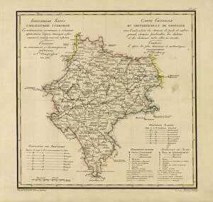
General Map of Moscow Province: Showing Postal and Major Roads, Stations and the.. 1821General Map of Moscow Province: Showing Postal and Major Roads, Stations and the Distance in Versts between Them, 1821. This 1821 map of Smolensk Provinceis from a larger work
Saint Petersburg Province, 1856. Creator: UnknownSaint Petersburg Province, 1856. This card is one of a souvenir set of 82 illustrated cards-one for each province of the Russian Empire as it existed in 1856
General Map of Tver Province: Showing Postal and Major Roads, Stations and the... 1821General Map of Tver Province: Showing Postal and Major Roads, Stations and the Distance in Versts between Them, 1821. This 1821 map of Tver Provinceis from a larger work
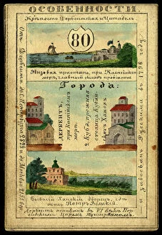
Derbent Province, 1856. Creator: UnknownDerbent Province, 1856. This card is one of a souvenir set of 82 illustrated cards-one for each province of the Russian Empire as it existed in 1856
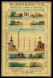
Nyland Province, 1856. Creator: UnknownNyland Province, 1856. This card is one of a souvenir set of 82 illustrated cards-one for each province of the Russian Empire as it existed in 1856
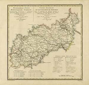
General Map of Novgorod Province: Showing Postal and Major Roads, Stations and the... 1821General Map of Novgorod Province: Showing Postal and Major Roads, Stations and the Distance in Versts between Them, 1821. This 1821 map of Novgorod Provinceis from a larger work
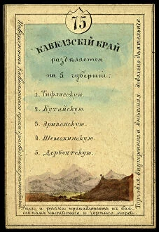
Caucasus Region, 1856. Creator: UnknownCaucasus Region, 1856. This card is one of a souvenir set of 82 illustrated cards-one for each province of the Russian Empire as it existed in 1856
Map of the Alaskan gold fields, 1897. Creator: T. S. LeeMap of the Alaskan gold fields, 1897. Beginning in the mid-19th century, gold was discovered in a succession of strikes along the western coast of the United States in an ascending arc
Olonetsk Province, 1856. Creator: UnknownOlonetsk Province, 1856. This card is one of a souvenir set of 82 illustrated cards-one for each province of the Russian Empire as it existed in 1856
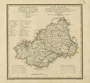
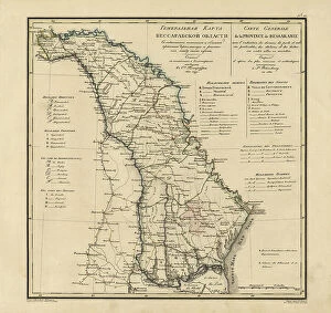
General Map of Bessarabia: Showing Postal and Major Roads, Stations and the... 1821General Map of Bessarabia: Showing Postal and Major Roads, Stations and the Distance in Versts between Them, 1821. This 1821 map of Bessarabia is from a larger work