mail_outline sales@mediastorehouse.com
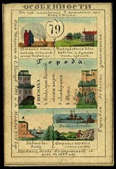
Shemakhinsk Province, 1856. Creator: UnknownShemakhinsk Province, 1856. This card is one of a souvenir set of 82 illustrated cards-one for each province of the Russian Empire as it existed in 1856
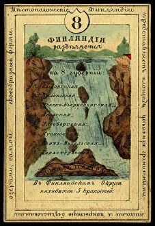
The Grand Duchy of Finland, 1856. Creator: UnknownThe Grand Duchy of Finland, 1856. This card is one of a souvenir set of 82 illustrated cards-one for each province of the Russian Empire as it existed in 1856
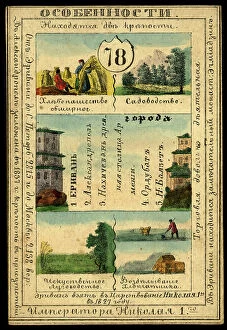
Erivan Province, 1856. Creator: UnknownErivan Province, 1856. This card is one of a souvenir set of 82 illustrated cards-one for each province of the Russian Empire as it existed in 1856
The Five-Year Plan of New Construction of Industry of the USSR: Map of the Asiatic Part... 1930 Creator: I. AThe Five-Year Plan of New Construction of Industry of the USSR: Map of the Asiatic Part of the USSR, 1930. Supplement to the map of the Five-Year plan of the European part of the USSR
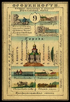
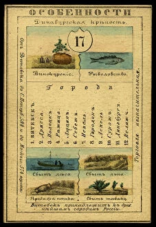
Vyborg Province, 1856. Creator: UnknownVyborg Province, 1856. This card is one of a souvenir set of 82 illustrated cards-one for each province of the Russian Empire as it existed in 1856
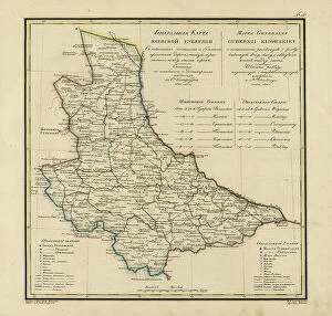
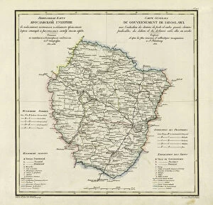
General Map of Minsk Province: Showing Postal and Major Roads, Stations and the... 1821General Map of Minsk Province: Showing Postal and Major Roads, Stations and the Distance in Versts between Them, 1821. This 1821 map of Minsk Province is from a larger work
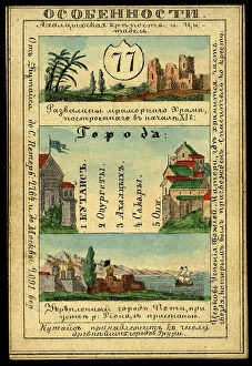
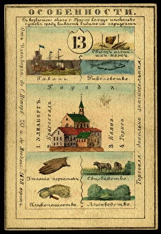
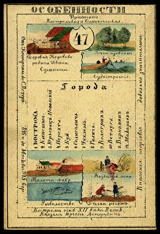
Kutaisi Province, 1856. Creator: UnknownKutaisi Province, 1856. This card is one of a souvenir set of 82 illustrated cards-one for each province of the Russian Empire as it existed in 1856
Abosko-B'erneborg Province, 1856. Creator: UnknownAbosko-B'erneborg Province, 1856. This card is one of a souvenir set of 82 illustrated cards-one for each province of the Russian Empire as it existed in 1856
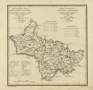
General Map of Vitebsk Province: Showing Postal and Major Roads, Stations and the... 1820General Map of Vitebsk Province: Showing Postal and Major Roads, Stations and the Distance in Versts between Them, 1820. This 1820 map of Vitebsk Provinceis from a larger work
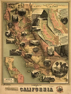
The unique map of California, 1888. Creator: E. McD. JohnstoneThe unique map of California, 1888. It was issued in 1888 by the Southern Pacific Railroad Company and the California State Board of Trade as part of a campaign to promote the economic, cultural
Tiflis Province, 1856. Creator: UnknownTiflis Province, 1856. This card is one of a souvenir set of 82 illustrated cards-one for each province of the Russian Empire as it existed in 1856
Vaasa Province, 1856. Creator: UnknownVaasa Province, 1856. This card is one of a souvenir set of 82 illustrated cards-one for each province of the Russian Empire as it existed in 1856
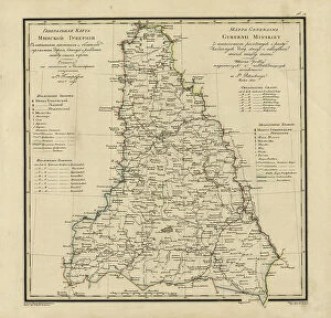
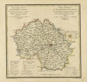
General Map of Moscow Province: Showing Postal and Major Roads, Stations and... 1821General Map of Moscow Province: Showing Postal and Major Roads, Stations and the Distance in Versts between Them, 1821. This 1821 map of Moscow Province is from a larger work
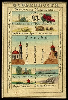
Stavropol Province, 1856. Creator: UnknownStavropol Province, 1856. This card is one of a souvenir set of 82 illustrated cards-one for each province of the Russian Empire as it existed in 1856
Uleaborg Province, 1856. Creator: UnknownUleaborg Province, 1856. This card is one of a souvenir set of 82 illustrated cards-one for each province of the Russian Empire as it existed in 1856
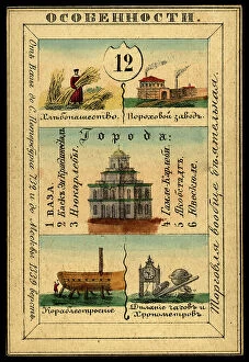
Yaroslavl Province, 1856. Creator: UnknownYaroslavl Province, 1856. This card is one of a souvenir set of 82 illustrated cards-one for each province of the Russian Empire as it existed in 1856
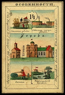
Kuopio Province, 1856. Creator: UnknownKuopio Province, 1856. This card is one of a souvenir set of 82 illustrated cards-one for each province of the Russian Empire as it existed in 1856
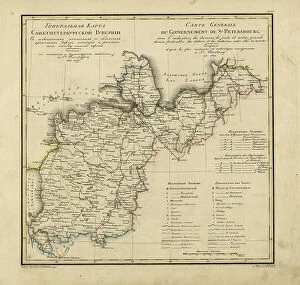
General Map of Saint Petersburg Province: Showing Postal and Major Roads, Stations and the... 1820General Map of Saint Petersburg Province: Showing Postal and Major Roads, Stations and the Distance in Versts between Them, 1820
Chernigov Province, 1856. Creator: UnknownChernigov Province, 1856. This card is one of a souvenir set of 82 illustrated cards-one for each province of the Russian Empire as it existed in 1856
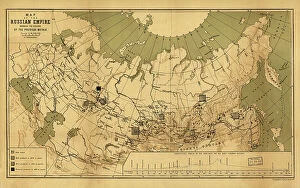
Map of the Russian Empire showing the regions of the precious metals, 1890. Creator: A. JlyneMap of the Russian Empire showing the regions of the precious metals, 1890
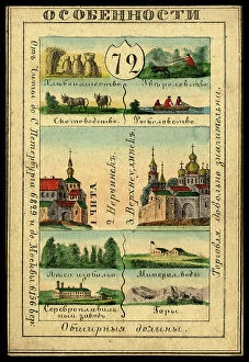
Transbaikal Region, 1856. Creator: UnknownTransbaikal Region, 1856. This card is one of a souvenir set of 82 illustrated cards-one for each province of the Russian Empire as it existed in 1856
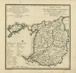
General Map of Livland Province: Showing Postal and Major Roads, Stations and the... 1820General Map of Livland Province: Showing Postal and Major Roads, Stations and the Distance in Versts between Them, 1820. This 1820 map of Livland Provinceis from a larger work
Russiae, Moskoviae et Tartariae descriptio, 1562. Creator: Anthony JenkinsonRussiae, Moskoviae et Tartariae descriptio, 1562. No. 1 Karta iz izdaniia: Atlas Aziatskoi Rossii.- SPb. Pereselencheskoe Upravlenie, kartogr. art. Zav. A.F. Marks, 1914
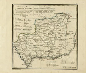
General Map of Kherson Province: Showing Postal and Major Roads, Stations and... 1821General Map of Kherson Province: Showing Postal and Major Roads, Stations and the Distance in Versts between Them, 1821. This 1821 map of Kherson Provinceis from a larger work
Land of the Black Sea Cossacks, 1856. Creator: UnknownLand of the Black Sea Cossacks, 1856. This card is one of a souvenir set of 82 illustrated cards-one for each province of the Russian Empire as it existed in 1856
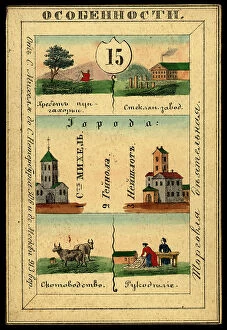
Saint Mikkel Province, 1856. Creator: UnknownSaint Mikkel Province, 1856. This card is one of a souvenir set of 82 illustrated cards-one for each province of the Russian Empire as it existed in 1856
Kostroma Province, 1856. Creator: UnknownKostroma Province, 1856. This card is one of a souvenir set of 82 illustrated cards-one for each province of the Russian Empire as it existed in 1856
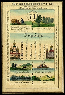
Yakutsk Region, 1856. Creator: UnknownYakutsk Region, 1856. This card is one of a souvenir set of 82 illustrated cards-one for each province of the Russian Empire as it existed in 1856
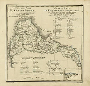
General Map of Courland Province: Showing Postal and Major Roads, Stations and the... 1820General Map of Courland Province: Showing Postal and Major Roads, Stations and the Distance in Versts between Them, 1820. This 1820 map of Courland Province is from a larger work
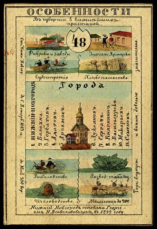
Nizhegorod Province, 1856. Creator: UnknownNizhegorod Province, 1856. This card is one of a souvenir set of 82 illustrated cards-one for each province of the Russian Empire as it existed in 1856
Vitebsk Province, 1856. Creator: UnknownVitebsk Province, 1856. This card is one of a souvenir set of 82 illustrated cards-one for each province of the Russian Empire as it existed in 1856
General Map of Kiev Province: Showing Postal and Major Roads, Stations and.. 1821General Map of Kiev Province: Showing Postal and Major Roads, Stations and the Distance in Versts between Them, 1821. This 1821 map of Kiev Province is from a larger work
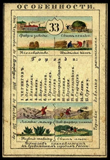
Kursk Province, 1856. Creator: UnknownKursk Province, 1856. This card is one of a souvenir set of 82 illustrated cards-one for each province of the Russian Empire as it existed in 1856
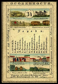
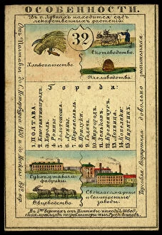
Poltava Province, 1856. Creator: UnknownPoltava Province, 1856. This card is one of a souvenir set of 82 illustrated cards-one for each province of the Russian Empire as it existed in 1856
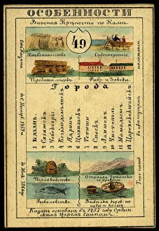
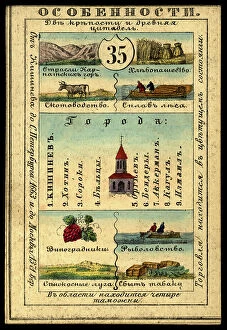
Kazan Province, 1856. Creator: UnknownKazan Province, 1856. This card is one of a souvenir set of 82 illustrated cards-one for each province of the Russian Empire as it existed in 1856
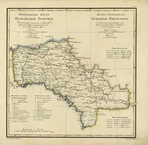
General Map of Podolsk Province: Showing Postal and Major Roads, Stations and the... 1820General Map of Podolsk Province: Showing Postal and Major Roads, Stations and the Distance in Versts between Them, 1820. This 1820 map of Podolsk Provinceis from a larger work
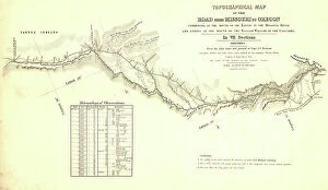
Topographical map of the road from Missouri to Oregon, commencing at the mouth of the Kansas...1846 CreatorsTopographical map of the road from Missouri to Oregon, commencing at the mouth of the Kansas in the Missouri River and ending at the mouth of the Walla-Wallah in the Columbia, 1846
Bessarabia Province, 1856. Creator: UnknownBessarabia Province, 1856. This card is one of a souvenir set of 82 illustrated cards-one for each province of the Russian Empire as it existed in 1856
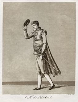
"L'Habit d'Ekolsund" - Lord in Gustaf III's so-called Ekolsundsdräkt, 1780s. Creator: J F Martin"L'Habit d'Ekolsund" - Lord in Gustaf III's so-called Ekolsundsdrakt, 1780s. Probably after drawing by J A Aleander, 1780s
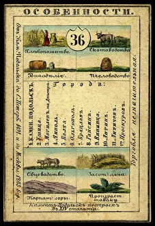
Kamenets-Podolsk Province, 1856. Creator: UnknownKamenets-Podolsk Province, 1856. This card is one of a souvenir set of 82 illustrated cards-one for each province of the Russian Empire as it existed in 1856
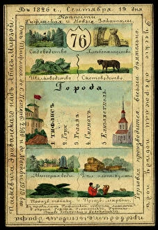
General Map of Yaroslavl Province: Showing Postal and Major Roads, Stations and the... 1822General Map of Yaroslavl Province: Showing Postal and Major Roads, Stations and the Distance in Versts between Them, 1822
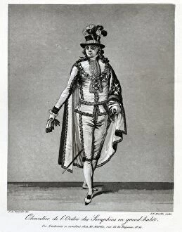
"Chevalier de l'Ordre des Seraphins en grand habit", 1780s. Creator: J F Martin"Chevalier de l'Ordre des Seraphins en grand habit", 1780s. Knight of the Order of Seraphim in grand habit - The Great Seraphim Robe
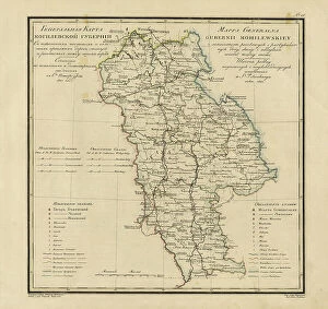
General Map of Mogilev Province: Showing Postal and Major Roads, Stations and... 1821General Map of Mogilev Province: Showing Postal and Major Roads, Stations and the Distance in Versts between Them, 1821. This 1821 map of Mogilev Provinceis from a larger work
Saratov Province, 1856. Creator: UnknownSaratov Province, 1856. This card is one of a souvenir set of 82 illustrated cards-one for each province of the Russian Empire as it existed in 1856
Tavastia Province, 1856. Creator: UnknownTavastia Province, 1856. This card is one of a souvenir set of 82 illustrated cards-one for each province of the Russian Empire as it existed in 1856
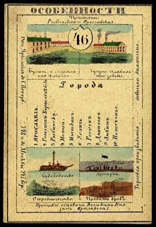
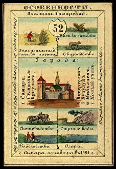
Samara Province, 1856. Creator: UnknownSamara Province, 1856. This card is one of a souvenir set of 82 illustrated cards-one for each province of the Russian Empire as it existed in 1856
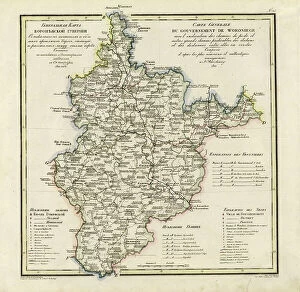
General Map of Voronezh Province: Showing Postal and Major Roads, Stations and the... 1822General Map of Voronezh Province: Showing Postal and Major Roads, Stations and the Distance in Versts between Them, 1822. This 1822 map of Voronezh Provinceis from a larger work
Kaunas Province, 1856. Creator: UnknownKaunas Province, 1856. This card is one of a souvenir set of 82 illustrated cards-one for each province of the Russian Empire as it existed in 1856