mail_outline sales@mediastorehouse.com
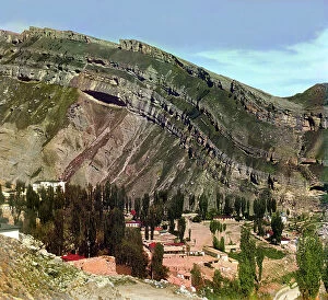
Village of Nizhnii Gunib in Dagestan, between 1905 and 1915. Creator: Sergey Mikhaylovich Prokudin-GorskyVillage of Nizhnii [or Nizhny] Gunib in Dagestan, between 1905 and 1915. {/33310/}, leader of the Chechen and Daghestani tribes, made his last stand against the Russians at Ghunib
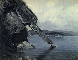
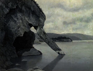
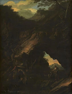
Cliff "Trunk" and Shaman's Rock, 1880-1897. Creator: Pavel Mikhailovich KosharovCliff "Trunk" and Shaman's Rock, 1880-1897. From a collection of paintings, lithographs, sketches, studies, and drawings
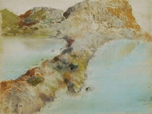
Rocky coast, about 1890/1892. Creator: Edgar DegasRocky coast, about 1890/1892
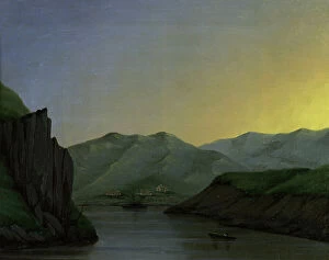
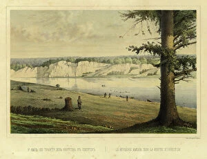
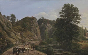
The River Irtysh Between the Fortress of Bukhtarminsk and the Town of Ust'-Kamenogorsk, 1880-1897. From a collection of paintings, lithographs, sketches, studies, and drawings
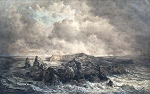
The island of St. Paul in the Indian Ocean, undated. (c1850s) Creator: Joseph SellenyThe island of St. Paul in the Indian Ocean, undated. (c1850s)
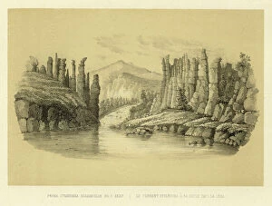
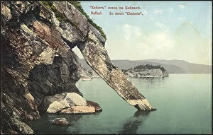
"Khabit" (Khobot) Rock and the Shaman's Stone at 4 Versts From the Village of Kaltuk... 1850-1899"Khabit" (Khobot) Rock and the Shaman's Stone at 4 Versts From the Village of Kaltuk- Lake Baikal, 1850-1899
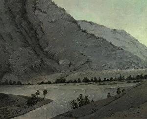
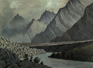
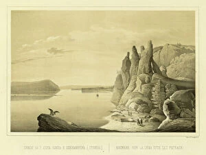
Crossing Over the River Katun Above Angudaia. View From the North. Altai, 1850-1899. From a collection of paintings, lithographs, sketches, studies, and drawings
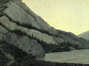
Mountain Landscape. Altai, 1850-1899. Creator: Pavel Mikhailovich KosharovMountain Landscape. Altai, 1850-1899. From a collection of paintings, lithographs, sketches, studies, and drawings, which capture various remote corners of the Siberian wilderness
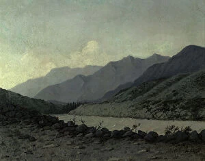
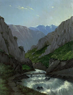
View of the Katun River Valley, 1850-1899. Creator: Pavel Mikhailovich KosharovView of the Katun River Valley, 1850-1899. From a collection of paintings, lithographs, sketches, studies, and drawings, which capture various remote corners of the Siberian wilderness
Jasper quarry on the Korgon River, 1880-1897. Creator: Pavel Mikhailovich KosharovJasper quarry on the Korgon River, 1880-1897. From a collection of paintings, lithographs, sketches, studies, and drawings, which capture various remote corners of the Siberian wilderness
White Bom on the Chu River View From the South West Altai, 1880-1897. Creator: Pavel Mikhailovich KosharovWhite Bom on the Chu River View From the South West Altai, 1880-1897. From a collection of paintings, lithographs, sketches, studies, and drawings
The Stolbovka Flowing into the Lena River, 1856. Creator: Ivan Dem'ianovich BulychevThe Stolbovka Flowing into the Lena River, 1856. From Puteshestviye po Vostochnoy Sibiri I. Bulychova. Chast 1-ya. Poyezdka v Kamchatku (A journey across eastern Siberia: Part 1, Trip to Kamchatka)
The Amga River on the Route from Yakutsk to Okhotsk, 1856. Creator: Ivan Dem'ianovich BulychevThe Amga River on the Route from Yakutsk to Okhotsk, 1856. From Puteshestviye po Vostochnoy Sibiri I. Bulychova. Chast 1-ya
Cliff Overhang Above the Lena River, 1856. Creator: Ivan Dem'ianovich BulychevCliff Overhang Above the Lena River, 1856. From Puteshestviye po Vostochnoy Sibiri I. Bulychova. Chast 1-ya. Poyezdka v Kamchatku (A journey across eastern Siberia: Part 1, Trip to Kamchatka)
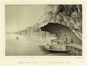
View of the Lena River at Ursk Gate, 1856. Creator: Ivan Dem'ianovich BulychevView of the Lena River at Ursk Gate, 1856. From Puteshestviye po Vostochnoy Sibiri I. Bulychova. Chast 1-ya. Poyezdka v Kamchatku (A journey across eastern Siberia: Part 1, Trip to Kamchatka)
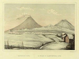
Klyuchevskoi Volcano, 1856. Creator: Ivan Dem'ianovich BulychevKlyuchevskoi Volcano, 1856. From Puteshestviye po Vostochnoy Sibiri I. Bulychova. Chast 1-ya. Poyezdka v Kamchatku (A journey across eastern Siberia: Part 1, Trip to Kamchatka)
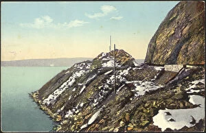
Lake Baikal, rock and excavation near the pier of Mysovaya station, 1904-1917. Creator: UnknownLake Baikal, rock and excavation near the pier of Mysovaya station, 1904-1917. National Library of Russia
"Trunk" rock on Lake Baikal, 1904-1917. Creator: Unknown. "Trunk" rock on Lake Baikal, 1904-1917"Trunk" rock on Lake Baikal, 1904-1917. National Library of Russia
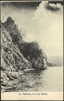
Lake Baikal, 1904-1914. Creator: UnknownLake Baikal, 1904-1914. This postcard is from the "Lake Baikal" series. National Library of Russia
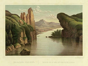
Cliffs (the Pillars) Above the Lena River near the City of Olekminsk, 1856. Creator: Ivan Dem'ianovich BulychevCliffs (the Pillars) Above the Lena River near the City of Olekminsk, 1856. From Puteshestviye po Vostochnoy Sibiri I. Bulychova. Chast 1-ya
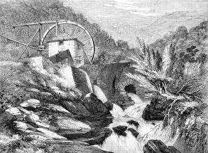
The Vigra Gold Mines, North Wales: the Crushing Mill, 1862. Creator: UnknownThe Vigra Gold Mines, North Wales: the Crushing Mill, 1862. The Vigra gold mines are situated in a most picturesque and mountainous range in the parish of Llanabar
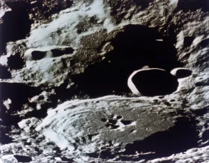
Craters on the Moon. Creator: NASACraters on the Moon
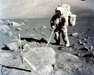
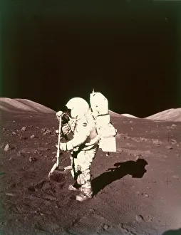
Harrison Schmitt works the scoop on the lunar surface, Apollo 17 mission, December 1972. US astronaut Harrison Schmitt (born 1935), the 12th man to walk on the Moon
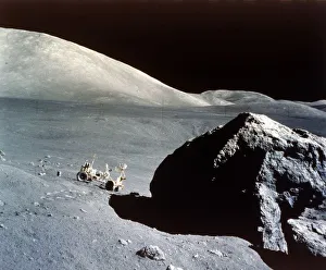
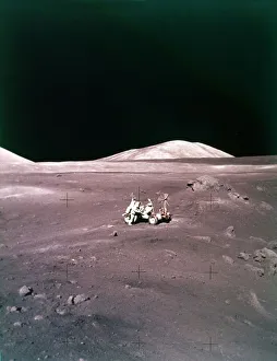
The Rover is dwarfed by a giant rock on the lunar surface, Apollo 17 mission, December 1972. US astronauts Eugene Cernan and Harrison Schmitt collected samples and drove the Lunar Roving Vehicle
Harrison Schmitt collects lunar rake samples, Apollo 17 mission, December 1972. Creator: NASAHarrison Schmitt collects lunar rake samples, Apollo 17 mission, December 1972. US astronaut Harrison Schmitt (born 1935), the 12th man to walk on the Moon
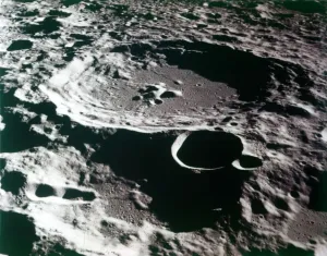
Close-up view of a crater on the surface of the Moon. Creator: NASAClose-up view of a crater on the surface of the Moon
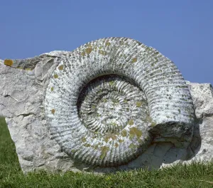
Giant fossil ammoniteA 70cm diameter fossil ammonite embedded in limestone, from Portland Stone Quarries in Dorset
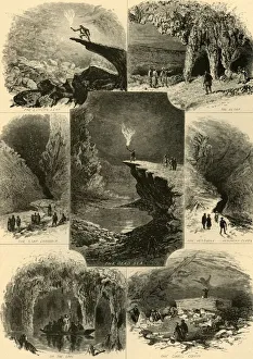
Scenes in Mammoth Cave, 1874. Creator: Alfred WaudScenes in Mammoth Cave, 1874. Tourists visit limestone caverns in Kentucky, USA, the longest cave system known in the world: The Lovers Leap; The Altar; The Star Chamber; The Dead Sea; The Vestibule
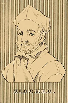
Kircher, (1602-1680), 1830. Creator: UnknownKircher, (1602-1680), 1830. Athanasius Kircher (1602-1680) German Jesuit scholar and polymath who published works on comparative religion, geology, and medicine
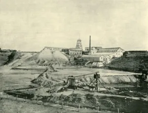
Gold Miners Near Beechworth, 1901. Creator: UnknownGold Miners Near Beechworth, 1901. Beechworth in the north-east of Victoria, Australia, saw major growth during the gold rush of the mid-1850s. From " Federated Australia"
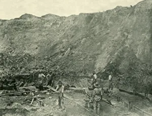
Star of the East Gold Mine, Ballarat, 1901. Creator: UnknownStar of the East Gold Mine, Ballarat, 1901. Ballarat on the Yarrowee River in the Central Highlands of Victoria, was transformed during the Victorian gold rush. From " Federated Australia"
Gold Diggers at Work near Beechworth, Victoria, 1901. Creator: UnknownGold Diggers at Work near Beechworth, Victoria, 1901. Beechworth in the north-east of Victoria, Australia, saw major growth during the gold rush of the mid-1850s
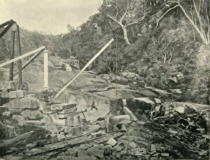
Granite Quarries, Trawool, Victoria, 1901. Creator: UnknownGranite Quarries, Trawool, Victoria, 1901. Trawool in central Victoria, on the middle reaches of the Goulburn River, first explored by Hume and Hovell in 1824, was later settled as a sheep station
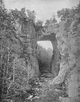
Natural Bridge, Virginia, c1897. Creator: UnknownNatural Bridge, Virginia, c1897. Natural arch in limestone gorge of Cedar Creek in Rockbridge County, Virginia purchased by Thomas Jefferson from King George III of England for 20 shillings in 1774
The Taurus-Littrow landing site, Apollo 17 mission, December 1972. Creator: NASAThe Taurus-Littrow landing site, Apollo 17 mission, December 1972. US astronauts Eugene Cernan and Harrison Schmitt collected samples and drove the Lunar Roving Vehicle on the Moon
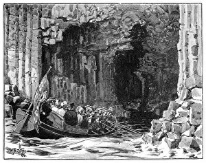
The Royal Visit to Fingals Cave, Staffa, Scotland, 1847, (1900). Artist: William Barnes WollenThe Royal Visit to Fingals Cave, Staffa, Scotland, 1847, (1900). Queen Victoria and Prince Albert visited the sea-cave on the uninhabited island of Staffa, in the Inner Hebrides of Scotland
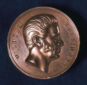
Wilhelm Haidinger, Austrian mineralogist, geologist and physicist, c1871Wilhelm Haidinger, Austrian mineralogist, geologist and physicist, 1871. In 1840 Haidinger (1795-1871) was appointed Counsellor of Mines, in Vienna
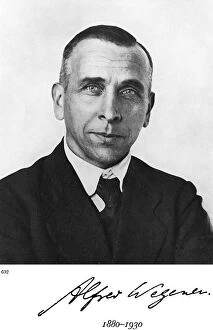
Alfred Lothar Wegener, German geophysicist and meteorologist. Wegener (1880-1930) formulated the theory of Continental Drift (Wegener Hypothesis), published in 1915
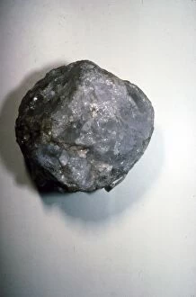
Paleolithic Quartz Pebble Tool, Olduvai, 1 to 2 million years old
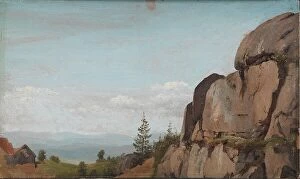
Norwegian Landscape with Rocks in the Foreground, 1830. Creator: Martinus RorbyeNorwegian Landscape with Rocks in the Foreground, 1830
Plauenscher Grund at Dresden, 1818. Creator: Johan Christian DahlPlauenscher Grund at Dresden, 1818
Landscape with an "Arco Naturale", 1630-1673. Creator: Salvator RosaLandscape with an "Arco Naturale", 1630-1673
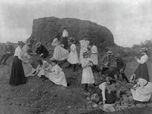
Washington, D.C. public schools field trip - 3rd Div. children examining rocks, (1899?)
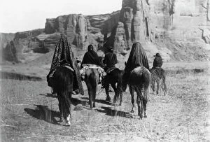
March through Tesacod Canyon, c1905. Creator: Edward Sheriff CurtisMarch through Tesacod Canyon, c1905. Rear view of Navajo Indians on horseback making their way over the sparse, dry, grassy floor of Tesacod Canyon
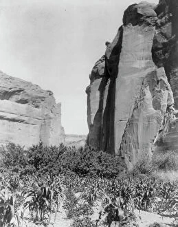
A Navaho farm, c1906. Creator: Edward Sheriff CurtisA Navaho farm, c1906. Patches of corn in garden between canyon walls
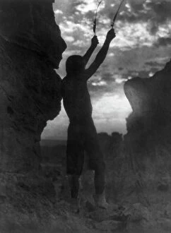
Offering to the sun-San Ildefonso, c1927. Creator: Edward Sheriff CurtisOffering to the sun-San Ildefonso, c1927. Barechested Tewa man with hands raised skyward, each holding a feather, as he faces the sun
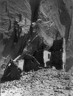
Antelope Ruin, Cañon del Muerto-Navaho, c1907. Creator: Edward Sheriff CurtisAntelope Ruin, Canon del Muerto-Navaho, c1907. Antelope House is an ancient pueblo named for nearby Navajo drawings in the Canyon de Chelly