mail_outline sales@mediastorehouse.com
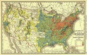
Rand, McNally & Co.'s map of the United States showing, in six degrees the density of pop... 1890Rand, McNally & Co.'s map of the United States showing, in six degrees the density of population, 1890, (1892). This map, published in 1892 by the Chicago-based Rand McNally and Company
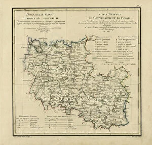
General Map of Pskov Province: Showing Postal and Major Roads, Stations and the Distance... 1820General Map of Pskov Province: Showing Postal and Major Roads, Stations and the Distance in Versts between Them, 1820. This 1820 map of Pskov Provinceis from a larger work
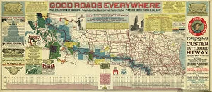
Touring map of the Custer Battlefield Hiway: the scenic route to the west, 1925. Creators: John C. Mulford, C. CTouring map of the Custer Battlefield Hiway: the scenic route to the west, 1925. The Custer Battlefield Highway was created in 1925 as a scenic route between Iowa and Montana
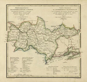
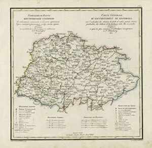
General Map of Ekaterinoslav Province: Showing Postal and Major Roads, Stations and the... 1821General Map of Ekaterinoslav Province: Showing Postal and Major Roads, Stations and the Distance in Versts between Them, 1821
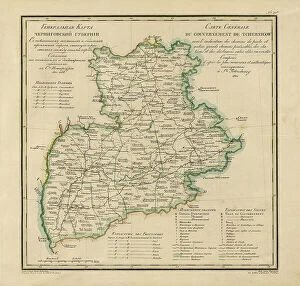
General Map of Chernigov Province: Showing Postal and Major Roads, Stations and... 1821General Map of Chernigov Province: Showing Postal and Major Roads, Stations and the Distance in Versts between Them, 1821
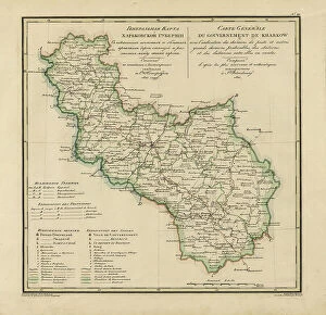
General Map of Kharkiv Province: Showing Postal and Major Roads, Stations and the... 1821General Map of Kharkiv Province: Showing Postal and Major Roads, Stations and the Distance in Versts between Them, 1821. This 1821 map of Kharkiv Provinceis from a larger work
General Map of Vladimir Province: Showing Postal and Major Roads, Stations and the... 1822General Map of Vladimir Province: Showing Postal and Major Roads, Stations and the Distance in Versts between Them, 1822. This 1822 map of Vladimir Provinceis from a larger work
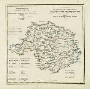
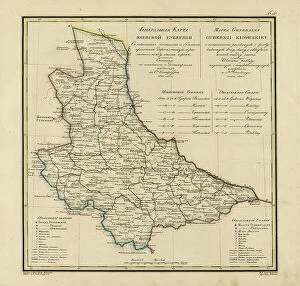
General Map of Kursk Province: Showing Postal and Major Roads, Stations and the... 1822General Map of Kursk Province: Showing Postal and Major Roads, Stations and the Distance in Versts between Them, 1822. This 1822 map of Kursk Provinceis from a larger work
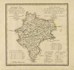
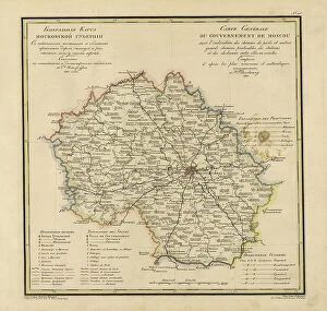
General Map of Moscow Province: Showing Postal and Major Roads, Stations and the.. 1821General Map of Moscow Province: Showing Postal and Major Roads, Stations and the Distance in Versts between Them, 1821. This 1821 map of Smolensk Provinceis from a larger work
General Map of Tver Province: Showing Postal and Major Roads, Stations and the... 1821General Map of Tver Province: Showing Postal and Major Roads, Stations and the Distance in Versts between Them, 1821. This 1821 map of Tver Provinceis from a larger work
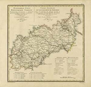
General Map of Novgorod Province: Showing Postal and Major Roads, Stations and the... 1821General Map of Novgorod Province: Showing Postal and Major Roads, Stations and the Distance in Versts between Them, 1821. This 1821 map of Novgorod Provinceis from a larger work
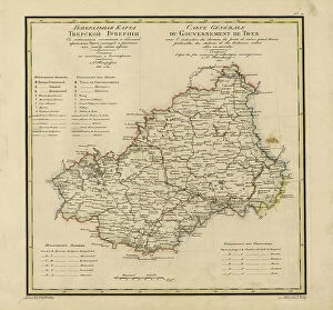
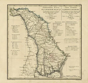
General Map of Bessarabia: Showing Postal and Major Roads, Stations and the... 1821General Map of Bessarabia: Showing Postal and Major Roads, Stations and the Distance in Versts between Them, 1821. This 1821 map of Bessarabia is from a larger work
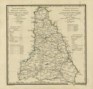
General Map of Minsk Province: Showing Postal and Major Roads, Stations and the... 1821General Map of Minsk Province: Showing Postal and Major Roads, Stations and the Distance in Versts between Them, 1821. This 1821 map of Minsk Province is from a larger work
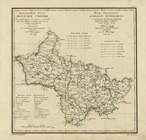
General Map of Vitebsk Province: Showing Postal and Major Roads, Stations and the... 1820General Map of Vitebsk Province: Showing Postal and Major Roads, Stations and the Distance in Versts between Them, 1820. This 1820 map of Vitebsk Provinceis from a larger work
General Map of Moscow Province: Showing Postal and Major Roads, Stations and... 1821General Map of Moscow Province: Showing Postal and Major Roads, Stations and the Distance in Versts between Them, 1821. This 1821 map of Moscow Province is from a larger work
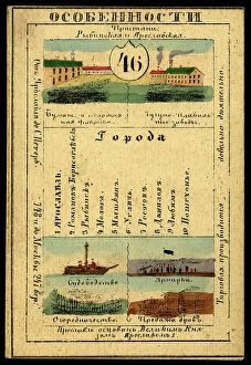
Yaroslavl Province, 1856. Creator: UnknownYaroslavl Province, 1856. This card is one of a souvenir set of 82 illustrated cards-one for each province of the Russian Empire as it existed in 1856
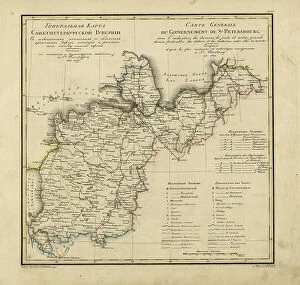
General Map of Saint Petersburg Province: Showing Postal and Major Roads, Stations and the... 1820General Map of Saint Petersburg Province: Showing Postal and Major Roads, Stations and the Distance in Versts between Them, 1820
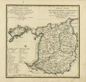
General Map of Livland Province: Showing Postal and Major Roads, Stations and the... 1820General Map of Livland Province: Showing Postal and Major Roads, Stations and the Distance in Versts between Them, 1820. This 1820 map of Livland Provinceis from a larger work
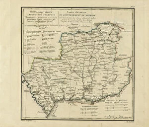
General Map of Kherson Province: Showing Postal and Major Roads, Stations and... 1821General Map of Kherson Province: Showing Postal and Major Roads, Stations and the Distance in Versts between Them, 1821. This 1821 map of Kherson Provinceis from a larger work
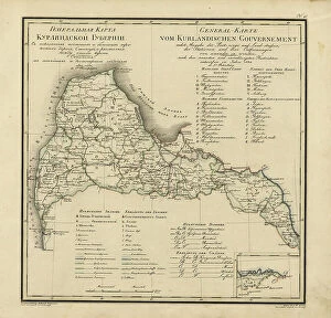
General Map of Courland Province: Showing Postal and Major Roads, Stations and the... 1820General Map of Courland Province: Showing Postal and Major Roads, Stations and the Distance in Versts between Them, 1820. This 1820 map of Courland Province is from a larger work
General Map of Kiev Province: Showing Postal and Major Roads, Stations and.. 1821General Map of Kiev Province: Showing Postal and Major Roads, Stations and the Distance in Versts between Them, 1821. This 1821 map of Kiev Province is from a larger work
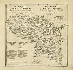
General Map of Vilnius Province: Showing Postal and Major Roads, Stations and the... 1820General Map of Vilnius Province: Showing Postal and Major Roads, Stations and the Distance in Versts between Them, 1820. This 1820 map of Vilnius Provinceis from a larger work
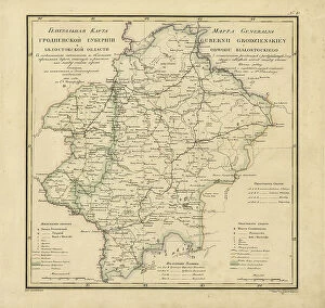
General Map of Grodno Province and the Belostok Region: Showing Postal and Major Roads... 1820General Map of Grodno Province and the Belostok Region: Showing Postal and Major Roads, Stations and the Distance in Versts between Them, 1820
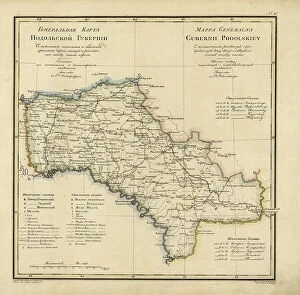
General Map of Podolsk Province: Showing Postal and Major Roads, Stations and the... 1820General Map of Podolsk Province: Showing Postal and Major Roads, Stations and the Distance in Versts between Them, 1820. This 1820 map of Podolsk Provinceis from a larger work
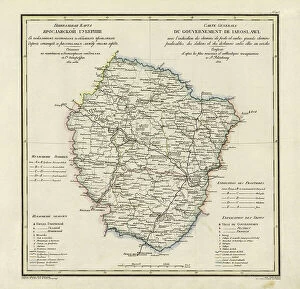
General Map of Yaroslavl Province: Showing Postal and Major Roads, Stations and the... 1822General Map of Yaroslavl Province: Showing Postal and Major Roads, Stations and the Distance in Versts between Them, 1822
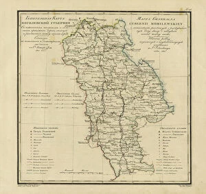
General Map of Mogilev Province: Showing Postal and Major Roads, Stations and... 1821General Map of Mogilev Province: Showing Postal and Major Roads, Stations and the Distance in Versts between Them, 1821. This 1821 map of Mogilev Provinceis from a larger work
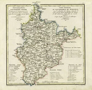
General Map of Voronezh Province: Showing Postal and Major Roads, Stations and the... 1822General Map of Voronezh Province: Showing Postal and Major Roads, Stations and the Distance in Versts between Them, 1822. This 1822 map of Voronezh Provinceis from a larger work
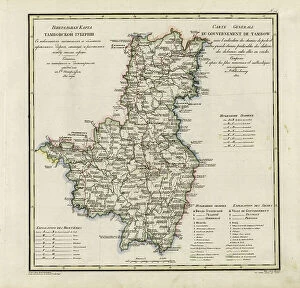
General Map of Tambov Province: Showing Postal and Major Roads, Stations and the... 1822General Map of Tambov Province: Showing Postal and Major Roads, Stations and the Distance in Versts between Them, 1822. This 1822 map of Tambov Provinceis from a larger work
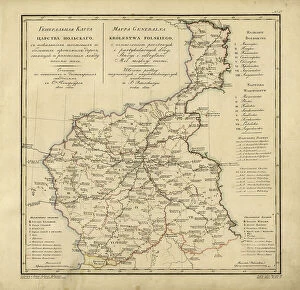
General Map of the Polish Empire: Showing Postal and Major Roads, Stations and the... 1820General Map of the Polish Empire: Showing Postal and Major Roads, Stations and the Distance in Miles Between Them, 1820. This 1820 map of the Polish Empire, then part of the Russian Empire
General Map of Kostroma Province: Showing Postal and Major Roads, Stations and... 1822General Map of Kostroma Province: Showing Postal and Major Roads, Stations and the Distance in Versts between Them, 1822. This 1822 map of Kostroma Provinceis from a larger work
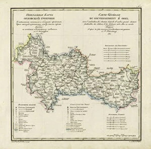
General Map of Orel Province: Showing Postal and Major Roads, Stations and... 1822General Map of Orel Province: Showing Postal and Major Roads, Stations and the Distance in Versts between Them, 1822. This 1822 map of Orel Province is from a larger work
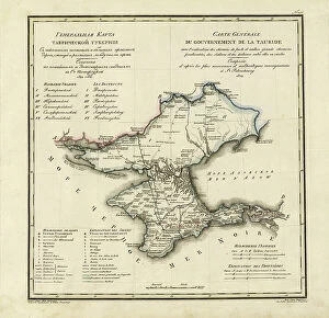
General Map of Taurida Province: Showing Postal and Major Roads, Stations and.. 1822General Map of Taurida Province: Showing Postal and Major Roads, Stations and the Distance in Versts between Them, 1822. This 1822 map ofTaurida Provinceis from a larger work
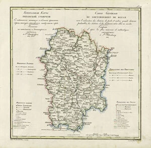
General Map of Ryazan Province: Showing Postal and Major Roads, Stations and... 1822General Map of Ryazan Province: Showing Postal and Major Roads, Stations and the Distance in Versts between Them, 1822. This 1822 map of Ryazan Provinceis from a larger work
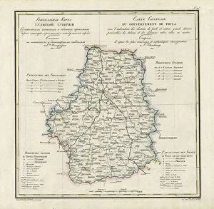
General Map of Tula Province: Showing Postal and Major Roads, Stations and... 1822General Map of Tula Province: Showing Postal and Major Roads, Stations and the Distance in Versts between Them, 1822. This 1822 map of Tula Provinceis from a larger work
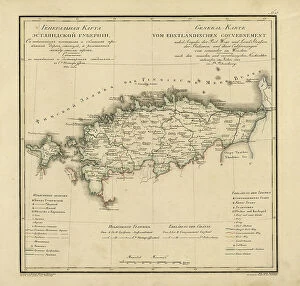
General Map of Estland Province: Showing Postal and Major Roads, Stations and... 1820General Map of Estland Province: Showing Postal and Major Roads, Stations and the Distance in Versts between Them, 1820. This 1820 map of Estland Province is from a larger work
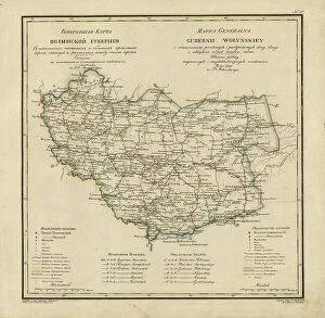
General Map of Volhynia Province: Showing Postal and Major Roads, Stations... 1820General Map of Volhynia Province: Showing Postal and Major Roads, Stations and the Distance in Versts between Them, 1820. This 1820 map of Volhynia Provinceis from a larger work
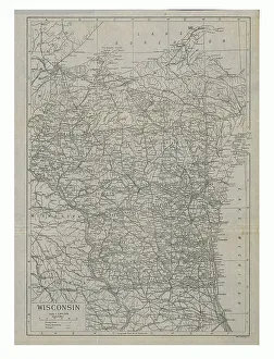
Map of Wisconsin, c1900. Artist: Carl HentschelMap of Wisconsin, c1900
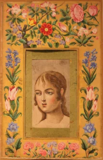
Painting of a Young Beauty, 1740s-50s. Creators: Muhammad Sadiq, Ali AkbarPainting of a Young Beauty, 1740s-50s
Devanandas Fourteen Auspicious Dreams Foretelling the Birth of Mahavira... ca. 1465Devanandas Fourteen Auspicious Dreams Foretelling the Birth of Mahavira: Folio from a Kalpasutra Manuscript, ca. 1465
Gobelins tapestry and lacework, France and Germany, early 19th century, (1898). Creator: UnknownGobelins tapestry and lacework, France and Germany, early 19th century, (1898). Fig 1: Panel of a Screen by Saint-Ange. Figs 2-5
Map of the Battle of Gravelotte, 18 August 1870, (c1872). Creator: R. WalkerMap of the Battle of Gravelotte, 18 August 1870, (c1872). Map: Drawn under the Superintendance of Captain Hozier, showing the enemy positions
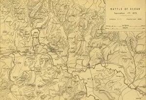
Map of the Battle of Sedan, 1 September 1870, (c1872). Creator: R. WalkerMap of the Battle of Sedan, 1 September 1870, (c1872). Map: Drawn under the Superintendance of Captain Hozier, showing the enemy positions
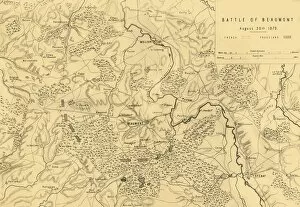
Map of the Battle of Beaumont, 30 August 1870, (c1872). Creator: R. WalkerMap of the Battle of Beaumont, 30 August 1870, (c1872). Map: Drawn under the Superintendance of Captain Hozier, showing the enemy positions
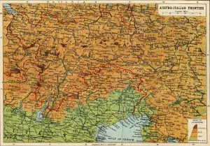
Map of the Austro-Italian frontier, First World War, (c1920). Creator: John Bartholomew & SonMap of the Austro-Italian frontier, First World War, (c1920). Mountainous area between Salzburg, Trieste and Cremona, showing the Tyrol
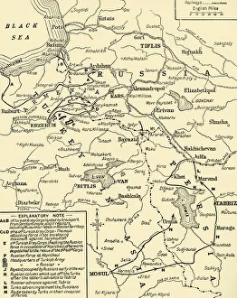
Map of the border between Russia and Turkey, First World War, (c1920). Creator: UnknownMap of the border between Russia and Turkey, First World War, (c1920). Map illustrating Turkeys disastrous Advance in the Caucasus and her Invasion of Persia - December, 1914 - January, 1915
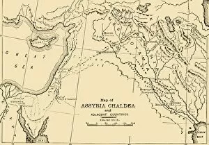
Map of Assyria, Chaldea and Adjacent Countries, 1890. Creator: UnknownMap of Assyria, Chaldea and Adjacent Countries, 1890. Assyria was a Mesopotamian kingdom from 25th century BC to 612 BC- 609 BC
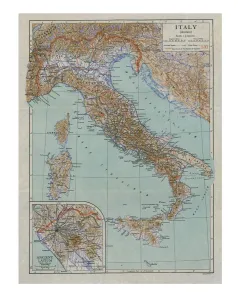
Map of Ancient Italy, c1910s. Artist: Emery Walker LtdMap of Ancient Italy, c1910s
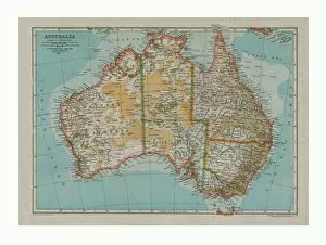
Map of Australia, c1910. Artist: Gull Engraving CompanyMap of Australia, c1910. [Encyclopaedia Britannica Co]