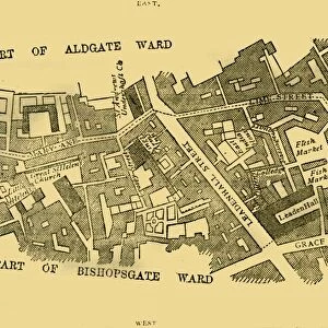
Cripplegate and Neighbourhood, (c1872). Creator: Unknown
. Creator: Unknown")
![]()
Wall Art and Photo Gifts from Heritage Images
Cripplegate and Neighbourhood, (c1872). Creator: Unknown
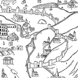
Cripplegate and Neighbourhood, (c1872). Map of part of the City of London dating from before the development of Finsbury Square in 1777. This area was previously a green space to the north of the City, here shown as Finsburie Fyeld (Finsbury Field). Also shown are the old Roman walls and More gate (Moorgate). From Old and New London, Vol. II: A Narrative of Its History, Its People, and Its Places, by Walter Thornbury. [Cassell, Petter, Galpin & Co. London, Paris & New York]
Media ID 18096799
© The Print Collector / Heritage-Images
Cassell Company Ltd City Walls Cripplegate Galpin Co Galpin Company George Walter George Walter Thornbury Neighbourhood Old And New London Petter Publisher Street Plan Thornbury Town Wall Urbanisation Walled City Walls
MADE IN THE UK
Safe Shipping with 30 Day Money Back Guarantee
FREE PERSONALISATION*
We are proud to offer a range of customisation features including Personalised Captions, Color Filters and Picture Zoom Tools
SECURE PAYMENTS
We happily accept a wide range of payment options so you can pay for the things you need in the way that is most convenient for you
* Options may vary by product and licensing agreement. Zoomed Pictures can be adjusted in the Basket.