Athelney & Ethandun 878, (1935)
")
![]()
Wall Art and Photo Gifts from Heritage Images
Athelney & Ethandun 878, (1935)
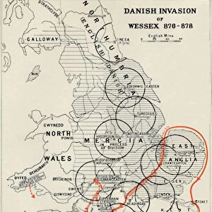
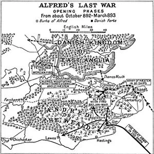
Athelney & Ethandun 878, (1935). Map of part of the west of England (modern Somerset, Dorset, Wiltshire and Hampshire), showing Athelney, which was once the fortress hiding place of King Alfred the Great. From there he went on to defeat the Danes at the Battle of Edington (or Ethandun) in May 878. The map also shows Roman roads and tracks, Alfreds Burhs (Old English fortifications), Danish forts, and significant sites during the period of Viking invasion. From A History of the Anglo-Saxons, Vol. II, by R. H. Hodgkin. [The Clarendon Press, Oxford, 1935]
Media ID 15466700
© The Print Collector / Heritage-Images
9th Century Aelfred Alfred I Alfred The Great Anglo Saxon County Dorset Hampshire King Alfred King Alfred The Great King Of Wessex Somerset Wessex Wiltshire
MADE IN THE UK
Safe Shipping with 30 Day Money Back Guarantee
FREE PERSONALISATION*
We are proud to offer a range of customisation features including Personalised Captions, Color Filters and Picture Zoom Tools
SECURE PAYMENTS
We happily accept a wide range of payment options so you can pay for the things you need in the way that is most convenient for you
* Options may vary by product and licensing agreement. Zoomed Pictures can be adjusted in the Basket.