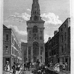
Moorfields and its Neighbourhood (From a Map of about 1720), (c1872). Creator: Unknown
, (c1872). Creator: Unknown")
![]()
Wall Art and Photo Gifts from Heritage Images
Moorfields and its Neighbourhood (From a Map of about 1720), (c1872). Creator: Unknown
Moorfields and its Neighbourhood (From a Map of about 1720), (c1872). Map of part of the City of London, showing the Moorfields, one of the last pieces of open land in the City. Also shown are Bunn Hill Fields, the Artillery Ground, Old Street, Hoxton Square and Shoreditch. From Old and New London, Vol. II: A Narrative of Its History, Its People, and Its Places, by Walter Thornbury. [Cassell, Petter, Galpin & Co. London, Paris & New York]
Media ID 18096787
© The Print Collector / Heritage-Images
Cassell Company Ltd Galpin Co Galpin Company George Walter George Walter Thornbury Hackney Moorfields Old And New London Old Street Petter Publisher Shoreditch Spitalfields Street Plan Thornbury Tower Hamlets Urbanisation
MADE IN THE UK
Safe Shipping with 30 Day Money Back Guarantee
FREE PERSONALISATION*
We are proud to offer a range of customisation features including Personalised Captions, Color Filters and Picture Zoom Tools
SECURE PAYMENTS
We happily accept a wide range of payment options so you can pay for the things you need in the way that is most convenient for you
* Options may vary by product and licensing agreement. Zoomed Pictures can be adjusted in the Basket.