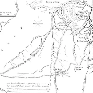
Map of the Country between Newcastle and the Transvaal, c1880

![]()
Wall Art and Photo Gifts from Heritage Images
Map of the Country between Newcastle and the Transvaal, c1880
Map of the Country between Newcastle and the Transvaal, c1880. From British Battles on Land and Sea, Vol. IV, by James Grant. [Cassell Petter & Galpin, London, Paris & Melbourne, c1880]
Media ID 14991929
© The Print Collector
Anglo Zulu Wars British Battles On Land And Sea Cassell Petter Galpin Grant Imperialism James Grant Kwazulu Natal Military Operation Newcastle Petter Galpin Plan South Africa South African Strategy Transvaal Zulu Wars
MADE IN THE UK
Safe Shipping with 30 Day Money Back Guarantee
FREE PERSONALISATION*
We are proud to offer a range of customisation features including Personalised Captions, Color Filters and Picture Zoom Tools
SECURE PAYMENTS
We happily accept a wide range of payment options so you can pay for the things you need in the way that is most convenient for you
* Options may vary by product and licensing agreement. Zoomed Pictures can be adjusted in the Basket.