
Topography Collection (page 2)

Background imageTopography Collection: The Shors demonstrate the main tools for cultivating the land (hoe - 'abyl', harrow) and..., 1913

The Shors demonstrate the main tools for cultivating the land (hoe - "abyl", harrow) and..., 1913
The Shors demonstrate the main tools for cultivating the land (hoe - "abyl", harrow) and grain (hand winnower, mortar, millstone), 1913

Background imageTopography Collection: Group of Shoria Men with Members of the Land-Management Expedition, 1913. Creator: GI Ivanov

Group of Shoria Men with Members of the Land-Management Expedition, 1913. Creator: GI Ivanov
Group of Shoria Men with Members of the Land-Management Expedition on the Shore - Gornaia Shoria Ulus Gathering, 1913. From a collection of 109 photographs taken during a 1913 topographic expedition

Background imageTopography Collection: Softening Leather, 1913. Creator: GI Ivanov

Softening Leather, 1913. Creator: GI Ivanov
Softening Leather, 1913. From a collection of 109 photographs taken during a 1913 topographic expedition to the Gornaia Shoria in the Altai region

Background imageTopography Collection: Shoria Women Making Shoes, 1913. Creator: GI Ivanov

Shoria Women Making Shoes, 1913. Creator: GI Ivanov
Shoria Women Making Shoes, 1913. From a collection of 109 photographs taken during a 1913 topographic expedition to the Gornaia Shoria in the Altai region

Background imageTopography Collection: Shoria Family Dressed in the 'City' Type Clothes, 1913. Creator: GI Ivanov

Shoria Family Dressed in the "City" Type Clothes, 1913. Creator: GI Ivanov
Shoria Family Dressed in the "City" Type Clothes, 1913. From a collection of 109 photographs taken during a 1913 topographic expedition to the Gornaia Shoria in the Altai region

Background imageTopography Collection: Old Woman Collecting Wood, 1913. Creator: GI Ivanov

Old Woman Collecting Wood, 1913. Creator: GI Ivanov
Old Woman Collecting Wood, 1913. From a collection of 109 photographs taken during a 1913 topographic expedition to the Gornaia Shoria in the Altai region

Background imageTopography Collection: Old Shoria Woman Collecting Wood; The Kumys Ulus, 1913. Creator: GI Ivanov

Old Shoria Woman Collecting Wood; The Kumys Ulus, 1913. Creator: GI Ivanov
Old Shoria Woman Collecting Wood; The Kumys Ulus, 1913. From a collection of 109 photographs taken during a 1913 topographic expedition to the Gornaia Shoria in the Altai region

Background imageTopography Collection: Shoria Men and Women Working on Cutting in the Woods, 1913. Creator: GI Ivanov

Shoria Men and Women Working on Cutting in the Woods, 1913. Creator: GI Ivanov
Shoria Men and Women Working on Cutting in the Woods, 1913. From a collection of 109 photographs taken during a 1913 topographic expedition to the Gornaia Shoria in the Altai region

Background imageTopography Collection: Cutting Through the Woods, 1913. Creator: GI Ivanov

Cutting Through the Woods, 1913. Creator: GI Ivanov
Cutting Through the Woods, 1913. From a collection of 109 photographs taken during a 1913 topographic expedition to the Gornaia Shoria in the Altai region

Background imageTopography Collection: Young Shoria Women with Children, 1913. Creator: GI Ivanov

Young Shoria Women with Children, 1913. Creator: GI Ivanov
Young Shoria Women with Children, 1913. From a collection of 109 photographs taken during a 1913 topographic expedition to the Gornaia Shoria in the Altai region

Background imageTopography Collection: Shoria Women, 1913. Creator: GI Ivanov

Shoria Women, 1913. Creator: GI Ivanov
Shoria Women, 1913. From a collection of 109 photographs taken during a 1913 topographic expedition to the Gornaia Shoria in the Altai region

Background imageTopography Collection: Shoria Woman Carrying a Load, 1913. Creator: GI Ivanov

Shoria Woman Carrying a Load, 1913. Creator: GI Ivanov
Shoria Woman Carrying a Load, 1913. From a collection of 109 photographs taken during a 1913 topographic expedition to the Gornaia Shoria in the Altai region

Background imageTopography Collection: Garden pavilion 'The Cave' at Jakobsdal (now Ulriksdal Palace), 1668. Creator: Adam Perelle

Garden pavilion "The Cave" at Jakobsdal (now Ulriksdal Palace), 1668. Creator: Adam Perelle
Garden pavilion "The Cave" at Jakobsdal (now Ulriksdal Palace), 1668

Background imageTopography Collection: La plaine de Monastir et son Cadre de Montagnes, 1916. Creator: Unknown

La plaine de Monastir et son Cadre de Montagnes, 1916. Creator: Unknown
La plaine de Monastir et son Cadre de Montagnes, 1916. From "Collection de la Guerre IV. L'Illustration Tome CXLVIII

Background imageTopography Collection: 'Source de la Tugela; Afrique Australe, 1914. Creator: Unknown

'Source de la Tugela; Afrique Australe, 1914. Creator: Unknown
'Source de la Tugela; Afrique Australe, 1914. From "Grande Geographie Bong Illustree", 1914

Background imageTopography Collection: 'Une vue des Drakensbergen; Afrique Australe, 1914. Creator: Unknown

'Une vue des Drakensbergen; Afrique Australe, 1914. Creator: Unknown
'Une vue des Drakensbergen; Afrique Australe, 1914. From "Grande Geographie Bong Illustree", 1914

Background imageTopography Collection: L'Heure de la Roumanie; La frontiere roumaine des Carpathes et des Alpes de Transylvanie, 1916

L'Heure de la Roumanie; La frontiere roumaine des Carpathes et des Alpes de Transylvanie, 1916. Creator: Julietta
L'Heure de la Roumanie; La frontiere roumaine des Carpathes et des Alpes de Transylvanie, 1916. From "Collection de la Guerre IV. L'Illustration Tome CXLVIII

Background imageTopography Collection: Topographic, Geographic and Music Engraving, from Encyclopédie, 1762/77. Creators: A. J

Topographic, Geographic and Music Engraving, from Encyclopédie, 1762/77. Creators: A. J. Defehrt, Madame de Lusse
Topographic, Geographic and Music Engraving, from Encyclopedie, 1762/77

Background imageTopography Collection: The author and research traveler Sven Hedin, 1897. Creator: Unknown

The author and research traveler Sven Hedin, 1897. Creator: Unknown
The author and research traveler Sven Hedin, 1897

Background imageTopography Collection: Touring map of the Custer Battlefield Hiway: the scenic route to the west, 1925. Creators: John C

Touring map of the Custer Battlefield Hiway: the scenic route to the west, 1925. Creators: John C. Mulford, C. C
Touring map of the Custer Battlefield Hiway: the scenic route to the west, 1925. The Custer Battlefield Highway was created in 1925 as a scenic route between Iowa and Montana

Background imageTopography Collection: Topographical sketch of the gold & quicksilver district of California, 1848. Creator: Edward Ord

Topographical sketch of the gold & quicksilver district of California, 1848. Creator: Edward Ord
Topographical sketch of the gold & quicksilver district of California, 1848. Published in July 1848 after the first gold strikes at Sutter's Mill on the American River in northern California

Background imageTopography Collection: Map of the mining district of California, 1850. Creator: William A. Jackson

Map of the mining district of California, 1850. Creator: William A. Jackson
Map of the mining district of California, 1850. The California gold rush of 1849 began with the strikes at Sutter's Mill on the American River near Sacramento

Background imageTopography Collection: Topographical map of the road from Missouri to Oregon, commencing at the mouth of

Topographical map of the road from Missouri to Oregon, commencing at the mouth of the Kansas...1846 Creators
Topographical map of the road from Missouri to Oregon, commencing at the mouth of the Kansas in the Missouri River and ending at the mouth of the Walla-Wallah in the Columbia, 1846

Background imageTopography Collection: Markly, 1835. Creator: Charles Mottram

Markly, 1835. Creator: Charles Mottram
Markly, (1835). Markly House, Warbleton, Sussex, ancestral home of the Darby family. John Darby was said to have profited as a merchant from naval contracts in the Napoleonic wars

Background imageTopography Collection: Frant Church, 1835. Creator: Unknown

Frant Church, 1835. Creator: Unknown
Frant Church, 1835. St. Albans Church in the Parish of Frant, Sussex. From " The History, Antiquities, and Topography of the County of Sussex, Volume the First", by Thomas Walker Horsfield

Background imageTopography Collection: The Temple Grammar School, Brighton, 1835. Creator: Henry Alexander Ogg

The Temple Grammar School, Brighton, 1835. Creator: Henry Alexander Ogg
The Temple Grammar School, Brighton, 1835. View of the Temple built by Thomas Read Kemp on Montpelier Road. Steel engraving by Henry Alexander Ogg after George Earpe

Background imageTopography Collection: Uckfield Lake, 1835. Creator: Henry Alexander Ogg

Uckfield Lake, 1835. Creator: Henry Alexander Ogg
Uckfield Lake, 1835. Antique line engraving by Henry Alexander Ogg after Thomas Henwood. From " The History, Antiquities, and Topography of the County of Sussex, Volume the First"

Background imageTopography Collection: Nash Court in Boughton, in the County of Kent, from Edward Hasted s, The History and To

Nash Court in Boughton, in the County of Kent, from Edward Hasted s, The History and To... 1777-90. Creator: Anon
Nash Court in Boughton, in the County of Kent, from Edward Hasted s, The History and Topographical Survey of the County of Kent, vols. 1-3, 1777-90

Background imageTopography Collection: Antiquities Dug up at Different Times in Crock-field near Newington, from Edward Hasted

Antiquities Dug up at Different Times in Crock-field near Newington, from Edward Hasted... 1777-90. Creator: Anon
Antiquities Dug up at Different Times in Crock-field near Newington, from Edward Hasted s, The History and Topographical Survey of the County of Kent, vols. 1-3, 1777-90

Background imageTopography Collection: Sutton Place, near Dartford, in the County of Kent, taken in the year 1766, before the... 1777-90

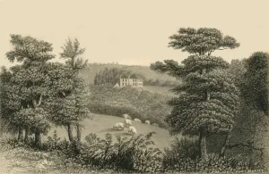
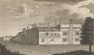
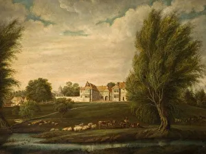
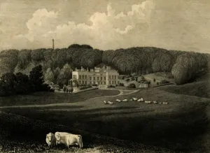
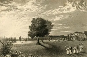
Sutton Place, near Dartford, in the County of Kent, taken in the year 1766, before the... 1777-90. Creator: Anon
Sutton Place, near Dartford, in the County of Kent, taken in the year 1766, before the alterations, from Edward Hasted s, The History and Topographical Survey of the County of Kent, vols. 1-3, 1777-90

Background imageTopography Collection: West Wickham Court in the County of Kent, from Edward Hasted s, The History and Topogra

West Wickham Court in the County of Kent, from Edward Hasted s, The History and Topogra... 1777-90. Creator: Anon
West Wickham Court in the County of Kent, from Edward Hasted s, The History and Topographical Survey of the County of Kent, vols. 1-3, 1777-90

Background imageTopography Collection: Solihull Church, 1870. Solihull, West Midlands. Creator: Unknown

Solihull Church, 1870. Solihull, West Midlands. Creator: Unknown
Solihull Church, 1870. Solihull, West Midlands

Background imageTopography Collection: Distant View Of Birdingbury Hall, Warwickshire, 1800. Creator: Unknown

Distant View Of Birdingbury Hall, Warwickshire, 1800. Creator: Unknown
Distant View Of Birdingbury Hall, Warwickshire, 1800

Background imageTopography Collection: Birdingbury Hall, Warwickshire, 1800. Creator: Unknown

Birdingbury Hall, Warwickshire, 1800. Creator: Unknown
Birdingbury Hall, Warwickshire, 1800

Background imageTopography Collection: Vera Effigies Guilielmi Burton / L. L. Baccalaurei, 1657-58. Creator: Wenceslaus Hollar

Vera Effigies Guilielmi Burton / L. L. Baccalaurei, 1657-58. Creator: Wenceslaus Hollar
Vera Effigies Guilielmi Burton / L.L. Baccalaurei, 1657-58

Background imageTopography Collection: Topographic Plan (Porto Ercole?) in the Shape of a Fan. Creator: Unknown

Topographic Plan (Porto Ercole?) in the Shape of a Fan. Creator: Unknown
Topographic Plan (Porto Ercole?) in the Shape of a Fan. Former attribution Stefano della Bella

Background imageTopography Collection: Title to Topographia Variarum Regionum, 1614. Creator: Simon Wynhoutsz Frisius

Title to Topographia Variarum Regionum, 1614. Creator: Simon Wynhoutsz Frisius
Title to Topographia Variarum Regionum, 1614

Background imageTopography Collection: Day 322, Survey U, Sectors 15 and 16, 1967. Creators: NASA

Day 322, Survey U, Sectors 15 and 16, 1967. Creators: NASA
Day 322, Survey U, Sectors 15 and 16, 1967

Background imageTopography Collection: Hevelius, (1611-1687), 1830. Creator: Unknown

Hevelius, (1611-1687), 1830. Creator: Unknown
Hevelius, (1611-1687), 1830. Johannes Hevelius (1611-1687) Polish councillor, mayor of Danzig and astronomer. From " Biographical Illustrations", by Alfred Howard. [Thomas Tegg, R

Background imageTopography Collection: Warnham Court, 1835. Creators: Unknown, Dean Wolstenholme

Warnham Court, 1835. Creators: Unknown, Dean Wolstenholme
Warnham Court, 1835. Grade II listed Jacobean mansion in Horsham, East Sussex built by Henry Tredcroft. Antique engraving by Dean Wolstenholm after Thomas Henwood

Background imageTopography Collection: Coolhurst, 1835. Creator: Charles J Smith

Coolhurst, 1835. Creator: Charles J Smith
Coolhurst, 1835. Coolhurst mansion and estate near Horsham in West Sussex. Antique line engraving by CJ Smith after Lady E Dickens

Background imageTopography Collection: Knepp Castle, 1835. Creator: Charles J Smith

Knepp Castle, 1835. Creator: Charles J Smith
Knepp Castle, 1835. Castellated mansion in West Grinstead, built c1808 by John Nash under the commission of Sir Charles M Burrell. Engraving by Charles J Smith after a drawing by Lady Burrell

Background imageTopography Collection: Dulany Cottage, 1835. Creator: Henry Alexander Ogg

Dulany Cottage, 1835. Creator: Henry Alexander Ogg
Dulany Cottage, 1835. Dulany House in Patching, West Sussex, leased by Sir Richard Hunter until 1848. Engraved by Henry A Ogg after a drawing by Thomas Henwood

Background imageTopography Collection: Muntham, 1835. Creator: Charles J Smith

Muntham, 1835. Creator: Charles J Smith
Muntham, 1835. Manor house in Horsham, home of FW Frankland until 1840. Antique engraving by CJ Smith after drawing by Thomas Henwood

Background imageTopography Collection: Climping Church, 1835. Creator: Charles J Smith

Climping Church, 1835. Creator: Charles J Smith
Climping Church, 1835. Grade I listed Church of St Mary in Climping, West Sussex. Antique line engraving by CJ Smith after JC Buckler

Background imageTopography Collection: Westdean House, 1835. Creator: Henry Alexander Ogg

Westdean House, 1835. Creator: Henry Alexander Ogg
Westdean House, 1835. West Dean House, Grade II listed country estate commissioned to architect James Wyatt by Lord Selsey. Antique engraving by Henry Alexander Ogg from a drawing by Thomas Henwood

Background imageTopography Collection: Sennicots, 1835. Creator: Henry Alexander Ogg

Sennicots, 1835. Creator: Henry Alexander Ogg
Sennicots, 1835. Sennicotts estate near Chichester, West Sussex, built in 1809 by Charles Baker who retired after serving in Madras with the British East India Company

Background imageTopography Collection: Heathfield Park, (1835). Creator: Charles Mottram

Heathfield Park, (1835). Creator: Charles Mottram
Heathfield Park, 1835. Georgian country estate of Charles Richard Blunt purchased after his return to England from collectorship in Dhaka


All Professionally Made to Order for Quick Shipping