mail_outline sales@mediastorehouse.com
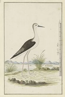
Himantopus himantopus ? (Black-winged stilt), 1777-1786. Creator: Robert Jacob GordonHimantopus himantopus ? (Black-winged stilt), 1777-1786
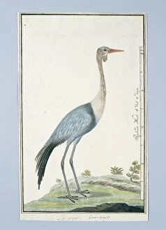
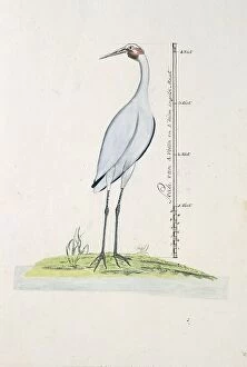
Grus carunculatus/ Bugeranus carunculatus (Wattled crane, 1777-1786. Creator: Robert Jacob Gordon)Grus carunculatus/ Bugeranus carunculatus (Wattled crane, 1777-1786
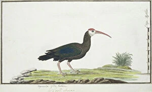
Geronticus calvus (Southern bald ibis), c.1778. Creator: Robert Jacob GordonGeronticus calvus (Southern bald ibis), c.1778
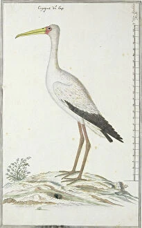
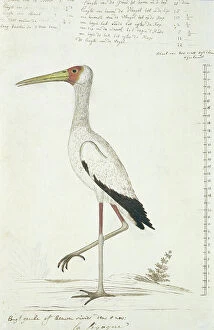
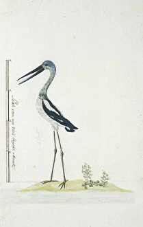
Mycteria ibis (Yellow-billed stork or Wood stork), c.1778. Creator: Robert Jacob GordonMycteria ibis (Yellow-billed stork or Wood stork), c.1778
Mycteria ibis (Yellow-billed stork), 1778. Creator: Robert Jacob GordonMycteria ibis (Yellow-billed stork), 1778
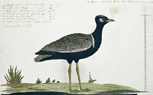
Afrotis afra (Southern black korhaan), 1778. Creator: Robert Jacob GordonAfrotis afra (Southern black korhaan), 1778
Struthio camelus (Common ostrich), 1777-1786. Creator: Robert Jacob GordonStruthio camelus (Common ostrich), 1777-1786
Creatophora cinerea (Wattled starling), 1777-1786. Creator: Robert Jacob GordonCreatophora cinerea (Wattled starling), 1777-1786
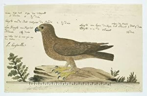
Hieraaetus pennatus (Booted eagle), 1777-1786. Creator: Robert Jacob GordonHieraaetus pennatus (Booted eagle), 1777-1786
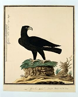
Aquila verreauxii (Verreaux's eagle), 1777-1786. Creator: Robert Jacob GordonAquila verreauxii (Verreaux's eagle), 1777-1786
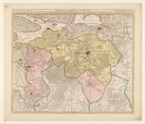
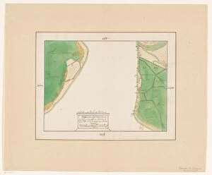
Map of the Baronie van Breda, c.1780. Creator: Nicolaes VisscherMap of the Baronie van Breda, c.1780. At the top left list of towns and villages. At the top right the scale in German and French miles
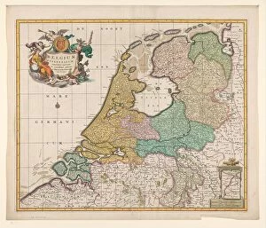
Map of the Republic of the Seven United Netherlands, 1677-1679. Creator: Nicolaes VisscherMap of the Republic of the Seven United Netherlands, 1677-1679. At the bottom right, the Maas from Maastricht to Wessem. At the top left the title in a cartouche surrounded by putti
Map of South Holland, c.1675. Creator: Nicolaes VisscherMap of South Holland, c.1675. With the west above. Scale in Dutch and French miles. Warships in a naval battle on the North Sea, the mouths of the Haringvliet and the Maas
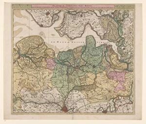
Map of North Flanders, c.1695. Creator: Nicolaes VisscherMap of North Flanders, c.1695. Showing part of Zeeland. Top right the scale in German and French miles
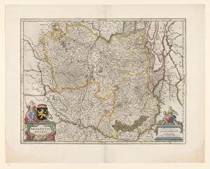
Map of Brabant, 1631. Creator: Willem BlaeuMap of Brabant, 1631. Map of the Duchy of Brabant. At the bottom right the scale in German miles. Bottom left the title between sphinxes, above it the coat of arms and woman with staff
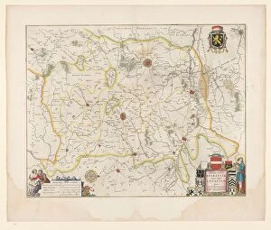
Map of Brabant, 1635. Creator: Michael van LangrenMap of Brabant, 1635. Prima pars Brabantiae cuius caput Lovanivm'. Top right: a coat of arms; bottom right: title in a cartouche with King David playing the harp
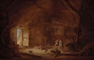
Interior of a Stable with three Children, 1642. Creator: Isaac van OstadeInterior of a Stable with three Children, 1642
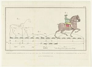
Movement of a horse from walking to trotting, with scale showing distances, 1739-1812. A precursor of Eadweard Muybridge, analysing stepping and pace
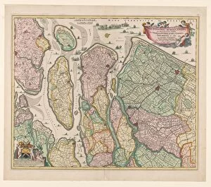
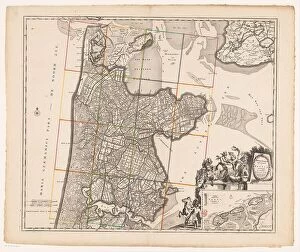
Map of Noord-Holland and part of Friesland, 1726-1750. Creator: AnonMap of Noord-Holland and part of Friesland, 1726-1750. At the bottom right the title cartouche with figures around it including a man with a horse, satyrs, putti
Men Bathing, 1650-1674. Creator: Gerbrand van den EeckhoutMen Bathing, 1650-1674
Macropus sp. (Kangaroo), 1788. Creator: John HunterMacropus sp. (Kangaroo), 1788. From Port Jackson (present-day Sydney, Australia)
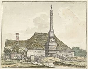
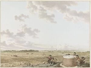
The milestone or ban pole at Halfweg, 1780. Creator: Jacques KuyperThe milestone or ban pole at Halfweg, 1780. Stone distance marker at Halfweg (halfway)
View of Table Mountain at Blaricum, with Craayloos Bosch on the left, c.1795. Creator: Jacob CatsView of Table Mountain at Blaricum, with Craayloos Bosch on the left, c.1795. In the 17th century, a stone orientation table was installed on the Tafelberg, a man-made hill
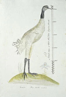
Antigone rubicunda (Brolga, or Australian Crane), 1770-1780. Creator: George RaperAntigone rubicunda (Brolga, or Australian Crane), 1770-1780
Grus rubicunda (Brolga or Australian crane), 1770-1780. Creator: George RaperGrus rubicunda (Brolga or Australian crane), 1770-1780
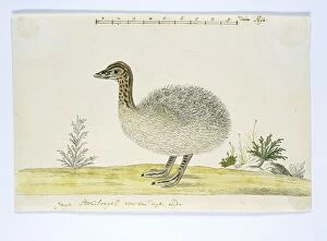
Dromaius novaehollandiae (Emu), 1770-1780. Creator: George RaperDromaius novaehollandiae (Emu), 1770-1780
Map of Eierland and West-Vlieland, 1688 or later. Creator: AnonMap of Eierland and West-Vlieland, 1688 or later. At the top right: scale of 800 rods Rijnlantsche size. At the bottom right the title
Map of East-Vlieland and West-Terschelling, 1688 or later. Creator: AnonMap of East-Vlieland and West-Terschelling, 1688 or later. At the bottom right the title with a scale of 900 Rijnlantse rods above it
Map of Den Helder and part of Texel with the intervening Marsdiep, in or after 1688. Creator: AnonMap of Den Helder and part of Texel with the intervening Marsdiep, in or after 1688. Scale of 500 Rijnlantse rods. Orientation: the north left
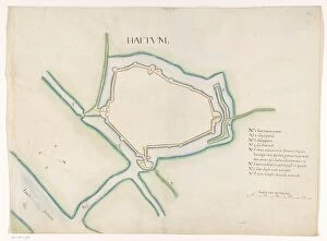
Hattem fortress map, c.1650-c.1799. Creator: AnonHattem fortress map, c.1650-c.1799. Key on the right; underneath a scale: range of 50 rods
Map of Elburg, c.1650-c.1799. Creator: AnonMap of Elburg, c.1650-c.1799. Key on the right; underneath a scale: range of 50 rods
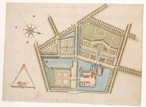
Map of Rosendael Castle, c.1650-before 1722. Creator: AnonMap of Rosendael Castle, c.1650-before 1722. Map of the castle and the gardens. Bottom left a compass with a scale: Rijnlande rods
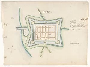
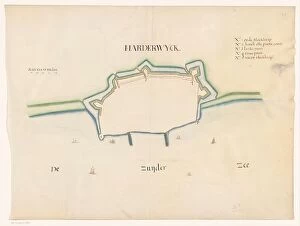
Plan of Harderwijk Fortress, c.1650-c.1799. Creator: AnonPlan of Harderwijk Fortress, c.1650-c.1799. On the left a scale: range of 50 rods
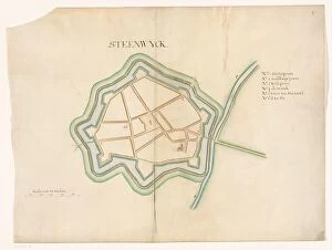
Map of Steenwijk Fortress, c.1650-c.1799. Creator: AnonMap of Steenwijk Fortress, c.1650-c.1799. Bottom left a scale: range of 50 rods. At the top right an inscription
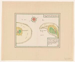
Map of Kuinre Fortification, c.1650-c.1799. Creator: AnonMap of Kuinre Fortification, c.1650-c.1799. Key bottom left; at bottom right a scale: range of 30 rods
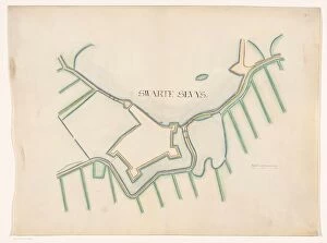
Map of Zwartsluis Fortification, c.1650-c.1799. Creator: AnonMap of Zwartsluis Fortification, c.1650-c.1799. On the right a scale: range of 30 rods
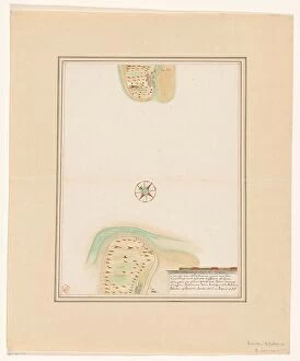
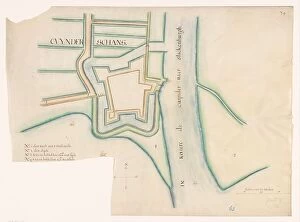
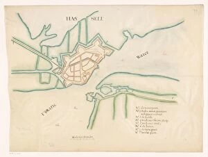
Map of Hasselt fortress, c.1650-c.1799. Creator: AnonMap of Hasselt fortress, c.1650-c.1799. Bottom left a scale: range of 80 rods. At the bottom right an inscription
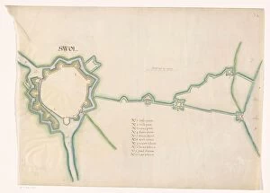
Map of Zwolle fortress, c.1650-c.1799. Creator: AnonMap of Zwolle fortress, c.1650-c.1799. In the centre a scale: range of 80 rods. Below that an inscription
Map of Thionville, c.1710. Creator: AnonMap of Thionville, c.1710. Map of the Fortress of Thionville (here spelled Theonville) on the Moselle. A scale at the bottom left
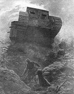
Le "Tank"; premiere apparition d'un des nouveaux cuirasses de terre de l'armee... 1916Le "Tank"; premiere apparition d'un des nouveaux cuirasses de terre de l'armee britannique au milieu des positions allemandes, a l'attaque du village de Flers
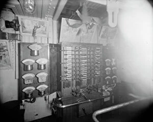
U.S.S. Oregon switchboard in dynamo room, between 1896 and 1901. Creator: Edward H HartU.S.S. Oregon switchboard in dynamo room, between 1896 and 1901
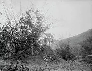
Bamboos on the Temasopa [sic], between 1880 and 1897. Creator: William H. JacksonBamboos on the Temasopa [sic], between 1880 and 1897
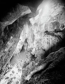
Interior, Choy Cave, Mexico, between 1880 and 1897. Creator: William H. JacksonInterior, Choy Cave, Mexico, between 1880 and 1897
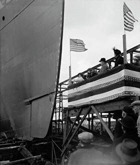
Str. Seeandbee, the christening, 1912 Nov 9. Creator: William H. JacksonStr. Seeandbee, the christening, 1912 Nov 9
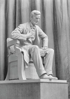
Sculpture of Abraham Lincoln by Mr. Haig Patigian, 1927 Creator: Arnold GentheSculpture of Abraham Lincoln by Mr. Haig Patigian, 1927
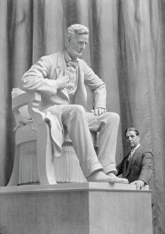
Patigian, Haig, Mr. with his Abraham Lincoln sculpture, portrait photograph, 1927 Creator: Arnold GenthePatigian, Haig, Mr. with his Abraham Lincoln sculpture, portrait photograph, 1927
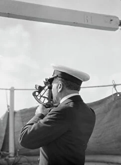
Vourekas, Captain, on his ship, 1929 Creator: Arnold GentheVourekas, Captain, on his ship, 1929
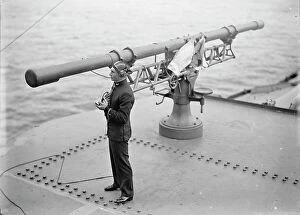
Target Practice - Range Finding Device, 1913. Creator: UnknownTarget Practice - Range Finding Device, 1913