mail_outline sales@mediastorehouse.com
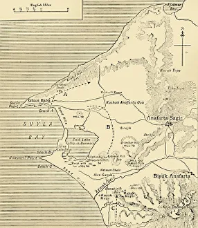
Map of Suvla Bay, Gallipoli peninsula, First World War, 1915, (c1920). Creator: UnknownMap of Suvla Bay, Gallipoli peninsula, First World War, 1915, (c1920). After the Suvla Bay Landing: Approximate Positions of General Stopfords Divisions on the night of August 7, 1915
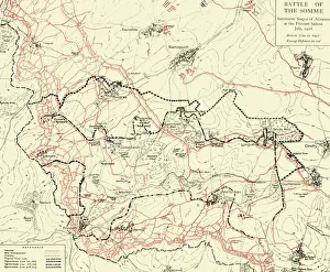
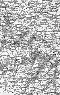
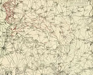
Battle of the Somme, First World War, July 1916, (c1920). Creator: UnknownBattle of the Somme, First World War, July 1916, (c1920). Map of northern France showing Successive Stages of Advance at the Fricourt Salient...British line in black, Enemy Defences [Germans] in red
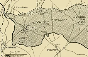
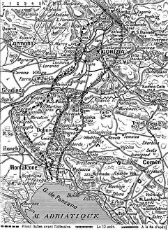
Map showing approximately the area gained on the Thiepval Ridge... 1916, (c1920)Map showing approximately the area gained on the Thiepval Ridge between September 14 and October 31, 1916, (c1920). The British line in northern France during the Battle of the Somme
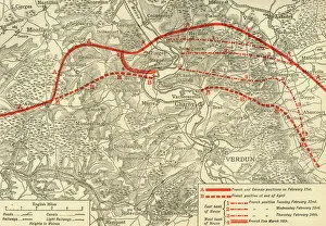
positions in the Battle of Verdun, northern France, First World War, 1916, (c1920)French and German positions in the Battle of Verdun, northern France, First World War, 1916, (c1920). Solid red line indicates French
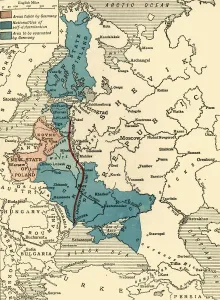
Map illustrating the Brest-Litovsk Treaties, First World War, c1918, (c1920). Creator: UnknownMap illustrating the Brest-Litovsk Treaties, First World War, c1918, (c1920). Pink: Areas taken by Germany ; dark blue: Nationalities of self-determination ; light blue
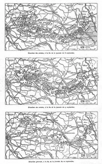
'Les Jours decisifs de la Marne; 8, 9, 10 septembre, 1914. Creator: Unknown'Les Jours decisifs de la Marne; 8, 9, 10 septembre, 1914. From "L'Album de la Guerre 1914-1919: Volume I". [L'Illustration, Paris, 1926]
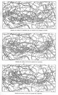
'Les Jours decisifs de la Marne; 5, 6, 7, septembre, 1914. Creator: Unknown'Les Jours decisifs de la Marne; 5, 6, 7 septembre, 1914. From "L'Album de la Guerre 1914-1919: Volume I". [L'Illustration, Paris, 1926]
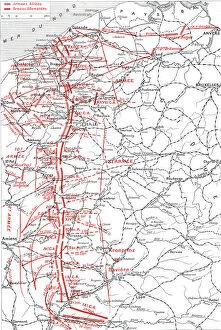
'La Course a la Mer; Les positions successives des armes alliees, du septembre au 17 october, 1914 Creator: Unknown'La Course a la Mer; Les positions successives des armes alliees, du septembre au 17 october, 1914. From "L'Album de la Guerre 1914-1919: Volume I". [L'Illustration, Paris, 1926]
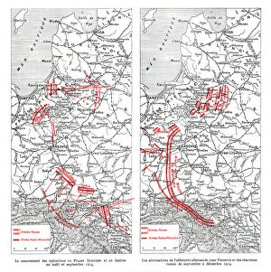
'Les operations du front oriental, 1914. Creator: Unknown'Les operations du front oriental, 1914. From "L'Album de la Guerre 1914-1919: Volume I". [L'Illustration, Paris, 1926]
'La Bataille de la Marne; Le mouvement de la bataille du 6 au 13 septembre, 1914. Creator: Unknown'La Bataille de la Marne; Le mouvement de la bataille du 6 au 13 septembre, 1914. From "L'Album de la Guerre 1914-1919: Volume I". [L'Illustration, Paris, 1926]
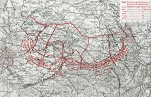
La grande attaque du Carso (aout 1916); La progression italienne sur le Carso, 1916. Creator: UnknownLa grande attaque du Carso (aout 1916); La progression italienne sur le Carso, 1916. From "Collection de la Guerre IV. L'Illustration Tome CXLVIII
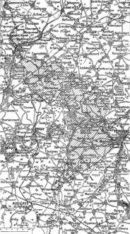
Ensemble du terrain des offensives franco-britanniques au Nord et au Sud de la Somme, 1916. Creator: UnknownEnsemble du terrain des offensives franco-britanniques au Nord et au Sud de la Somme. Le grise indique l'avance realisee a la date 5 septembre
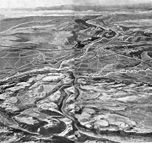
Les Italiens a Gorizia; Croquis perspectif de la vallee de l'Isonzo, 1916. Creator: UnknownLes Italiens a Gorizia; Croquis perspectif de la vallee de l'Isonzo des environs de Gorizia et du Carso, 1916. From "Collection de la Guerre IV. L'Illustration Tome CXLVIII
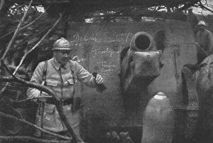
L'offensive de la Somme: L'attaque du juillet 1916; le general B, 1916. Creator: UnknownL'offensive de la Somme: L'attaque du juillet 1916; le general B, commandant une division coloniale, visite une batterie allemande, qui etait encore en position et fut prise par ses troupes
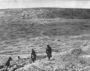
L'offensive de la Somme: L'attaque du juillet 1916; les premieres lignes allemandes, 1916. Creator: UnknownL'offensive de la Somme: L'attaque du juillet 1916; le terrain des premieres lignes allemandes (region de Curlu), completement bouleverse par notre artillerie, 1916
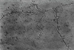
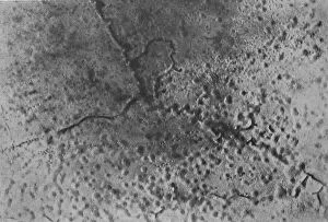
L'offensive de la Somme: L'attaque du 1er juillet 1916 observee d'un aeroplane, 1916. Creator: UnknownL'offensive de la Somme: L'attaque du 1er juillet 1916 observee d'un aeroplane; La tranchee allemande de Stuttgart, au Nord de la route de Foucaucourt a Estrees
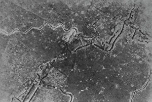
L'offensive de la Somme: L'attaque du 1er juillet 1916 observee d'un aeroplane, 1916. Creator: UnknownL'offensive de la Somme: L'attaque du 1er juillet 1916 observee d'un aeroplane; Nos fantassins occupent la tranchee allemande de Landsberg, a 500 metres au Sud de Fay, 1916
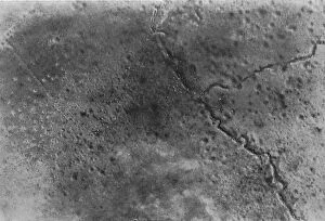
L'offensive de la Somme; la preparation d'une bataille: L'attaque du 1er juillet 1916, 1916L'offensive de la Somme; la preparation d'une bataille: L'attaque du 1er juillet 1916 observee d'un aeroplane; Tranchee allemande a un kilometre au Sud-Ouest de Fay
L'offensive de la Somme; la preparation d'une bataille: L'attaque du 1er juillet 1916, 1916L'offensive de la Somme; la preparation d'une bataille: L'attaque du 1er juillet 1916 observee d'un aeroplane; Tranchees de depart garnies de troupes
La Guerre 20-26 juillet 1916; Carte-croquis du terrain au Nord et au Sud de la Somme, 1916. Creator: UnknownLa Guerre 20-26 juillet 1916; Carte-croquis du terrain au Nord et au Sud de la Somme. Le grise indique l'avance franco-britannique a la date du 26 juillet, 1916
La Guerre 20-26 juillet 1916; cartes des ouvrages allemands d'Ovillers a Hardecourt, 1916. Creator: UnknownLa Guerre 20-26 juillet 1916; cartes des ouvrages allemands d'Ovillers a Hardecourt, communiquee officiellement a la presse britannique
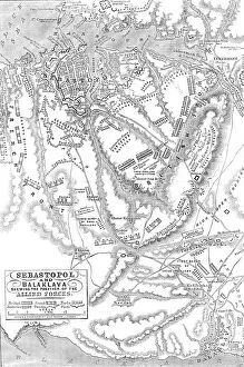
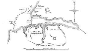
Sebastopol and Balaclava shewing the position of the Allied Forces, 1854. Creator: John DowerSebastopol and Balaclava shewing the position of the Allied Forces, 1854. Crimean War. The severe and costly battles of Balaclava and Inkerman
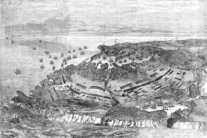
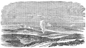
The Siege of Sebastopol - general view, 1854. Creator: UnknownThe Siege of Sebastopol - general view, 1854. Crimean War. Map showing the Russian-held ports of Sebastopol and Balaclava, harbours and warships
The Siege of Sebastopol - portion of redoubt, occupied and evacuated by the Russians, 1854. Creator: UnknownThe Siege of Sebastopol - portion of redoubt, occupied and evacuated by the Russians, 1854. Crimean War. As our cavalry moved on, supported by our artillery
The Coast North of Sebastopol, and New Earth Batteries, 1854. Creator: UnknownThe Coast North of Sebastopol, and New Earth Batteries, 1854. Crimean War. Map of the strategic Black Sea port, ...sketched on board H.M.S
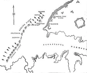
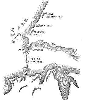
New Russian Works, 1854. Creator: UnknownNew Russian Works, 1854. Crimean War. Map showing the besieged Black Sea port of Sebastopol. English, French and Turkish ships are ranged across the entrance to the harbour
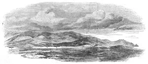
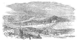
The Siege of Sebastopol - Valley of Inkerman, 1854. Creator: UnknownThe Siege of Sebastopol - Valley of Inkerman, 1854. Crimean War. Landscape around the besieged Black Sea port, showing: English Sentries; Ruins of Inkerman; Cossack Field Guns; River Inkerman...The
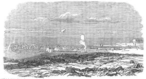
Sebastopol during the Siege - general view, 1854. Creator: UnknownSebastopol during the Siege, 1854. Crimean War: the Black Sea, the battlefield, allied and Russian positions: "Twelve Apostles" (three-decker [warship]); Barracks; Gordon's Battery
Sebastopol during the Siege - general view, 1854. Creator: UnknownSebastopol during the Siege - general view, 1854. Crimean War. View of warships on the Black Sea, the battlefield, and positions of the allies and the Russians
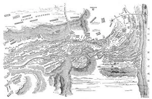
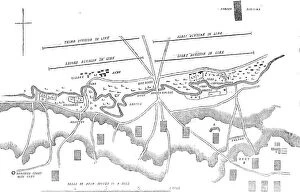
Plan of the Battle of the Alma, 1854. Creator: UnknownPlan of the Battle of the Alma, 1854. Crimean War. The accompanying plan has been drawn by Major Hopkins, K.H. The different armies are represented by the variety of lines of shade
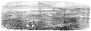
British Outposts, near Sebastopol, 1854. Creator: UnknownBritish Outposts, near Sebastopol, 1854. Crimean War: panorama showing Cossacks; Fort; English Steamer; Russian Soldiers Camp Cooking Houses
Official Plan of the Battle of the Alma - Distribution of the British Troops at the... 1854. Creator: UnknownOfficial Plan of the Battle of the Alma - Distribution of the British Troops at the Commencement of the Action, 1854. Crimean War. A. Battery of twelve heavy guns (24 lbs); B. Four heavy guns; C
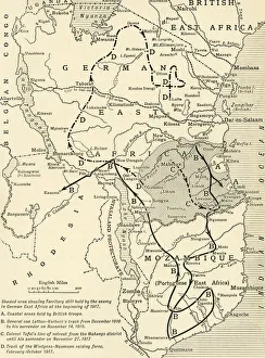
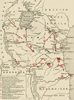
Map illustrating the Closing Phases of the East African Campaign, 1917-18, (c1920). European powers in Africa during the First World War
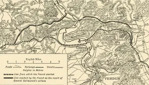
Map illustrating the Operations at Verdun, First World War, August-November, 1917, (c1920). Map of the area around the town of Verdun in northern France, showing Line from which the French started
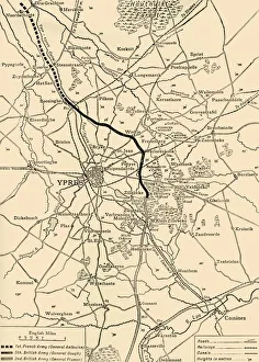
Map of Ypres, West Flanders, Belgium, First World War, (c1920). Creator: UnknownMap of Ypres, West Flanders, Belgium, First World War, (c1920). The Ypres Salient before the Battle of July 31, 1917: map showing the approximate positions of the Franco-British Line
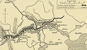
The Allies Line facing the Bulgarians in the closing Campaign of 1916, (c1920). Map of Salonika (Thessaloniki) in Greece, showing Allied positions during the First World War: Russian, French
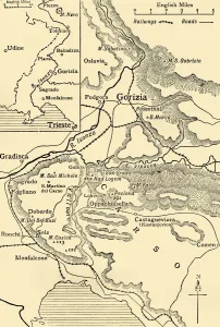
Gorizia and the Carso: map illustrating the Italian advance towards Trieste in 1916, (c1920). Italian lines in northern Italy during the First World War
Colonial possessions in East Africa during the First World War, c1916, (c1920). Creator: UnknownColonial possessions in East Africa during the First World War, c1916, (c1920). Map showing German East Africa, British East Africa, the Belgian Congo, Rhodesia, Uganda
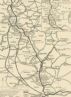
Map illustrating the German Retirement after the Battle of the Somme, (c1920). Creator: UnknownMap illustrating the German Retirement after the Battle of the Somme, (c1920). The First World War Battle of the Somme, fought between the armies of the British Empire
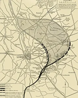
The Ypres Salient before and after the Second Battle of Ypres... First World War, 1915, (c1920)The Ypres Salient before and after the Second Battle of Ypres, April 22-May 13, First World War, 1915, (c1920). Map showing positions of the allied forces around Ypres in Belgium: French
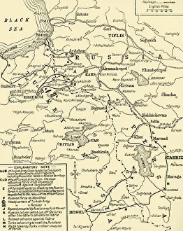
Map of the border between Russia and Turkey, First World War, (c1920). Creator: UnknownMap of the border between Russia and Turkey, First World War, (c1920). Map illustrating Turkeys disastrous Advance in the Caucasus and her Invasion of Persia - December, 1914 - January, 1915
Plan of the Attack at 5.30pm, when these were almost exclusively the Ships engaged with the... 1854 Creator: UnknownPlan of the Attack at 5.30pm, when these were almost exclusively the Ships engaged with the Forts, 1854. Crimean War. Map showing the besieged Black Sea port of Sebastopol
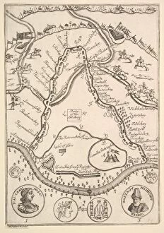
Parke of the Artillary (Aubry de La Mottrayes "Travels throughout EuropeParke of the Artillary (Aubry de La Mottrayes " Travels throughout Europe, Asia and into Part of Africa... " London, 1724, vol. II, pl. 26B), 1723-24
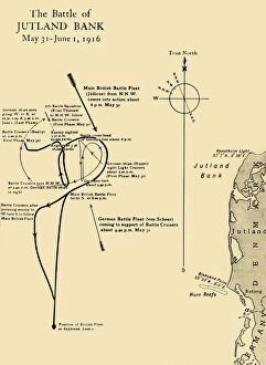
The Battle of Jutland Bank, May 31-June 1, 1916, (c1920). Creator: UnknownThe Battle of Jutland Bank, May 31-June 1, 1916, (c1920). Map showing the Approximate Positions of the British and German Fleets at Various Stages of the Battle
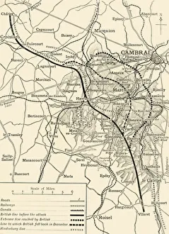
Map illustrating the First Battles of Cambrai, November-December 1917, (c1920). Creator: UnknownMap illustrating the First Battles of Cambrai, November-December 1917, (c1920). Note - Hill shading is shown only in the area covered by the sphere of operations described
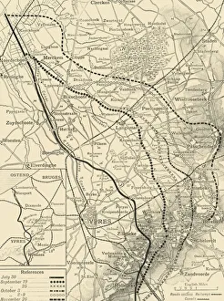
The Battles of the Flanders Ridges, July 30-November 26, 1917, (c1920). Creator: UnknownThe Battles of the Flanders Ridges, July 30-November 26, 1917, (c1920)....map illustrating successive stages of the Allies advance...inset
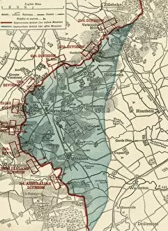
Map to illustrate the Battle of Messines, First World War, June 1917, (c1920). Creator: UnknownMap to illustrate the Battle of Messines, First World War, June 1917, (c1920). The blue area shows ground gained from the Germans by the British under General Sir Herbert Plumer, 7-14 June 1917
Battle of the Somme, First World War, 1916, (c1920). Creator: UnknownBattle of the Somme, First World War, 1916, (c1920). Successive Lines of Advance, North of the Somme: 1st July till 30th November, 1916