mail_outline sales@mediastorehouse.com
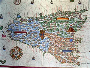
Atlas of Joan Martines, Messina, 1582. Portulan chart of the island of Sicily
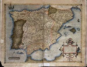
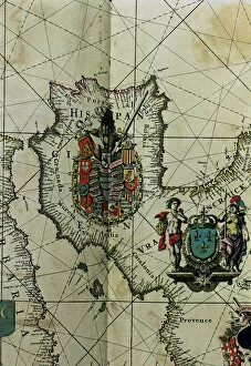
Theatrum Orbis Terrarum by Abraham Ortelius, Antwerp, 1574. Map of the Iberian Peninsula
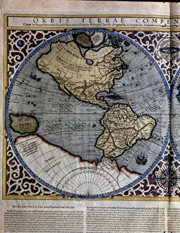
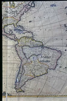
Atlas of Gerardus Mercator, 1595, map of the Americas and part of Antarctica
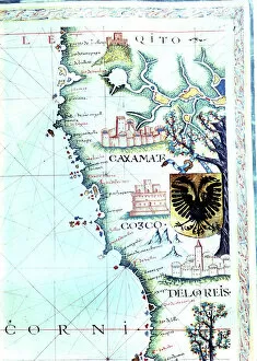
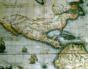
Map of the Pacific coast along the present nations of Ecuador and Peru, with villages of Quito, Cajamarca, Cuzco and Lima, detail of a map of the Atlas
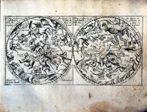
Heavenly Globes, name and figures of the celestial constellations and signs of the Arctic and Antarctic Poles. French engraving of 1667
Map of Spain with all their kingdoms, Portugal and the Country of Llenguadoc. Atlas by Frederick de Witt
Map of South America, West Indies, Central America and east coast of North America Atlas
Map of the current Central America, the Caribbean and northern South America, in the Theatrum Orbis Terrarum of 1574 by Abraham Ortelius
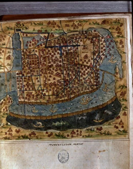
Map of Tenochtitlan, Mexico, 1560, in the work General Islands of the World, by the chronicler and cosmographer Alonso de Santa Cruz
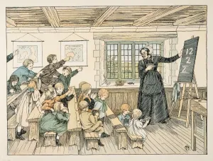
The Dame, from Four and Twenty Toilers, pub. 1900 (colour lithograph). accompanies verse by E.V. Lucas (Edward Verrall Lucas) (1868 – 1938);
Map of Nagasaki, c1801(Map of Nagasaki, c 1801 (colour woodcut)
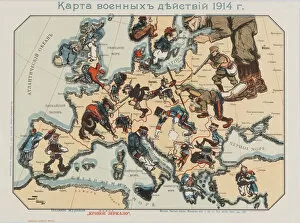
Map of the 1914 war activities, edited by the Moscow magazine New Distorted Mirror, 1914-1915. Found in the collection of State Hermitage, St. Petersburg
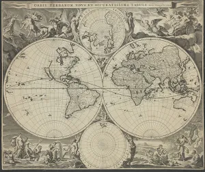
Orbis terrarum nova et accuratissima tabula, ca 1690. Artist: Visscher, Nicolaes (1618-1679)Orbis terrarum nova et accuratissima tabula, ca 1690. Private Collection
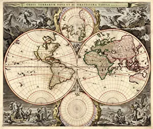
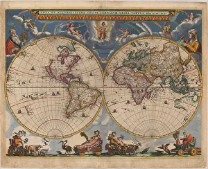
Double hemisphere map of the World, 1662. Artist: Blaeu, Joan (1596-1673)Double hemisphere map of the World, 1662. Private Collection
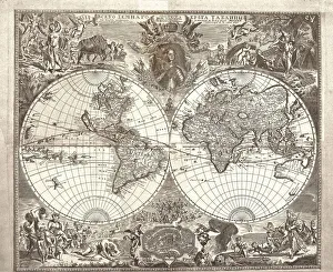
Double hemisphere map of the World, 1713. Artist: Kiprianov, Vasily Anufrievich (1669-after 1723)Double hemisphere map of the World, 1713. Found in the collection of Russian National Library, St. Petersburg
Double hemisphere map of the World, 1707. Artist: Kiprianov, Vasily Anufrievich (1669-after 1723)Double hemisphere map of the World, 1707. Found in the collection of Russian National Library, St. Petersburg
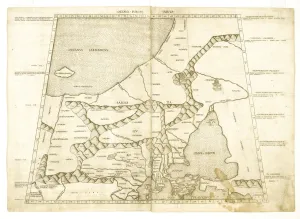
Map of Muscovy by Ptolemy (Octava Europe Tabula). Artist: Anonymous masterMap of Muscovy by Ptolemy (Octava Europe Tabula). Private Collection
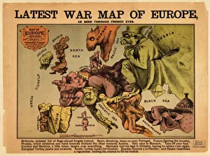
Latest war map of Europe: as seen through French eyes. Artist: Hadol, Paul (1835-1875)Latest war map of Europe: as seen through French eyes. Private Collection
The Odessa Map. Artist: AnonymousThe Odessa Map. Private Collection
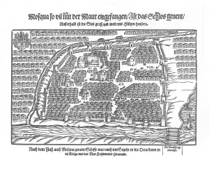
The Moscow Map (From Moscouiter wunderbare Historien by Sigmund von Herberstein), 1567. Artist: AnonymousThe Moscow Map (From Moscouiter wunderbare Historien by Sigmund von Herberstein), 1567. Found in the collection of the State History Museum, Moscow
Ptolemy World map. Artist: Germanus, Donnus Nicolaus (ca. 1420-ca. 1490)Ptolemy World map. Private Collection
Double hemisphere map of the World. Artist: Blaeu, Joan (1596-1673)Double hemisphere map of the World. Private Collection
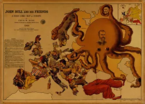
John Bull and his Friends. A Serio-Comic Map of Europe. Artist: Fred W. Rose (active End of 19th cen. )John Bull and his Friends. A Serio-Comic Map of Europe. Private Collection
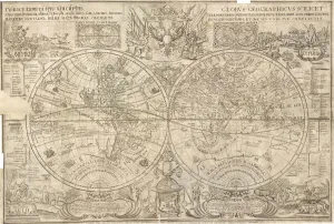
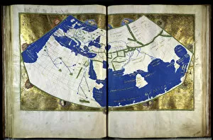
Geographia by Ptolemy, ca 1454. Artist: Anonymous masterGeographia by Ptolemy, ca 1454. Found in the collection of the Biblioteca Nazionale Marciana, Venice
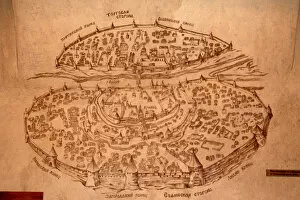
The Novgorod Map, 17th century. Artist: Historical DocumentThe Novgorod Map, 17th century. Found in the collection of the State Open-air Museum of History and Architecture Novgorodian Kremlin, Novgorod
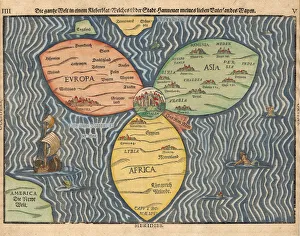
The three continents with Jerusalem in the center of the World, 1581. Artist: Bunting, Heinrich (1545-1606)The three continents with Jerusalem in the center of the World, 1581. Private Collection
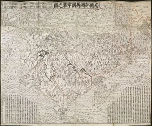
The Buddhist world map, 1710. Artist: Rokashi Hotan, Zuda (1654-1738)The Buddhist world map, 1710. Private Collection
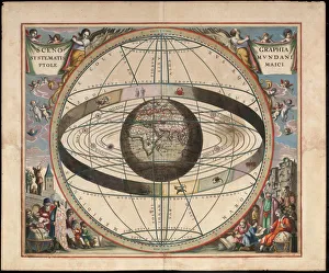
Scenography of the Ptolemaic cosmography (From Andreas Cellarius Harmonia Macrocosmica), c. 1660. From a private collection