mail_outline sales@mediastorehouse.com
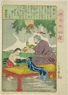
Huang Xiang (Ko Kyo), from the series "Twenty-four Paragons of Filial Piety in China... c. 1848/50Huang Xiang (Ko Kyo), from the series "Twenty-four Paragons of Filial Piety in China (Morokoshi nijushiko)", c. 1848/50
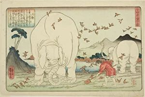
Dashun (Taishun), from the series "Twenty-four Paragons of Filial Piety as a Mirror for... c. 1843Dashun (Taishun), from the series "Twenty-four Paragons of Filial Piety as a Mirror for Children (Nijushiko doji kagami)", c. 1843
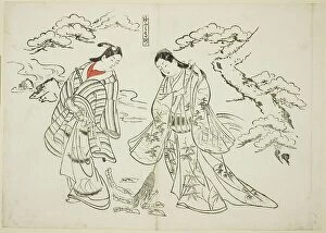
Sleeve-Letter Takasago (Sodefumi Takasago), no. 2 from a series of 12 prints...plays, c. 1716/35Sleeve-Letter Takasago (Sodefumi Takasago), no. 2 from a series of 12 prints depicting parodies of plays, c. 1716/35
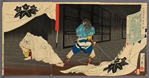
Tokimune (Soga Goro) Sneaking into Yoritomo's Residence (Tokimune...), Japan, 1891. Creator: Migita ToshihideTokimune (Soga Goro) Sneaking into Yoritomo's Residence (Tokimune Kamakura-dono no kariya o sawagasu), Japan, 1891
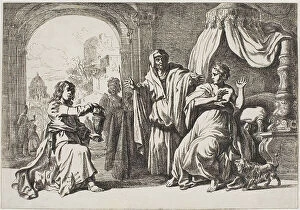
Sophonisba Receiving the Poisoned Cup, n.d. Creator: Pieter LastmanSophonisba Receiving the Poisoned Cup, n.d
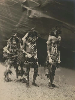
Yeibichai war gods, 1904, c1905. Creator: Edward Sheriff CurtisYeibichai war gods, 1904, c1905. Photograph shows three Natives: Tonenili, Tobadzischini, and Nayenezgani, in ceremonial dress, photographed against dark rock background
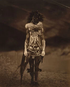
Nayenezgani-Navaho, 1904, c1905. Creator: Edward Sheriff CurtisNayenezgani-Navaho, 1904, c1905. Indian, full-length portrait, standing, facing front, wearing dark leather mask, fur ruff, cloth girdle, silver concho belt and necklaces
Nayenezgani-Navaho, 1904, c1905. Creator: Edward Sheriff CurtisNayenezgani-Navaho, 1904, c1905. Indian, half-length portrait, facing front, wearing dark mask, fur ruff, paint on torso
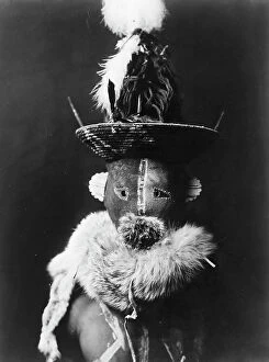
Zahadolzha-Navaho, 1904, c1905. Creator: Edward Sheriff CurtisZahadolzha-Navaho, 1904, c1905. Indian, head-and-shoulders portrait, facing front, wearing leather mask with basket cap, fur ruff, torso painted with white lines
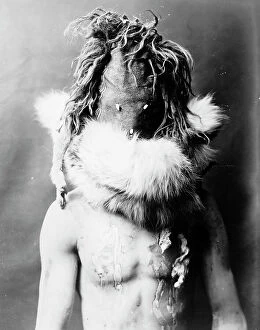
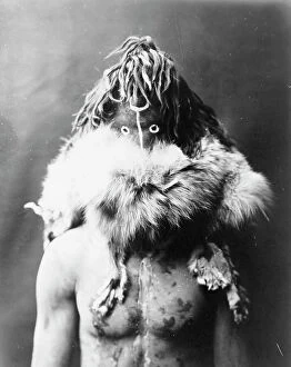
Haschezhini-Navaho, 1904, c1905. Creator: Edward Sheriff CurtisHaschezhini-Navaho, 1904, c1905. Photo shows a Native American man, half-length portrait, facing front, wearing dark leather mask, fur ruff, torso painted with black and white splotches
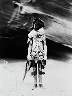
Nayenezgani, c1904. Creator: Edward Sheriff CurtisNayenezgani, c1904. Nayenezgani, a Navajo deity, full-length portrait, facing front, wearing body paints and other adornments
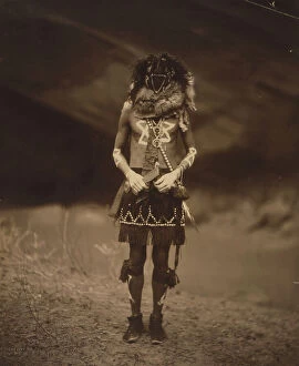
Tobadzischini-Navaho, c1904. Creator: Edward Sheriff CurtisTobadzischini-Navaho, c1904. Navajo man in ceremonial dress as Tobadzischini, Yebichai war god
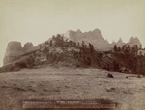
Crow Butte Near Ft Robinson, Neb and FE & MV RR -- In battle, the Indians drove the "Crows" up on the mountain and camped on the only approach
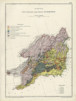
Map of the Nerchinsk Region from the Office of His Majesty, 1914. CreatorMap of the Nerchinsk Region from the Office of His Majesty, 1914. From the atlas "Atlas of Asian Russia."
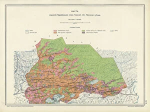
Map on the drainage of the Barabinsk steppe in the Tomsk province, Kainsk district, 1914. From the atlas "Atlas of Asian Russia."
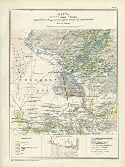
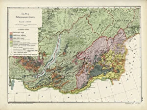
Map of the barren steppe of the Khodzhentsk distric, Samarkand region, with its environs, 1914. From the atlas "Atlas of Asian Russia."
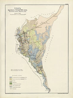
Plan Murgabskogo Gosudareva imeniia, Zakaspiiskoi oblasti, Mervskogo uezda, 1914. From the atlas "Atlas of Asian Russia."
Map of the Altai Region from the Office of His Majesty, 1914. Creator: Resettlement Department of the Land RegulationMap of the Altai Region from the Office of His Majesty, 1914. From the atlas "Atlas of Asian Russia."
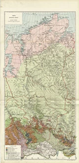
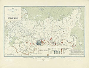
Map of Zabaikal Province, 1914. Creator: Resettlement Department of the Land Regulation and Agriculture AdministrationMap of Zabaikal Province, 1914. From the atlas "Atlas of Asian Russia."
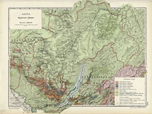
Map of Enisei Province, 1914. Creator: Resettlement Department of the Land Regulation and Agriculture AdministrationMap of Enisei Province, 1914. From the atlas "Atlas of Asian Russia."
Map of Irkutsk Province, 1914. Creator: Resettlement Department of the Land Regulation and Agriculture AdministrationMap of Irkutsk Province, 1914. From the atlas "Atlas of Asian Russia."
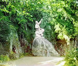
In Monrepos Park in Vyborg, between 1905 and 1915. Creator: Sergey Mikhaylovich Prokudin-GorskyIn Monrepos Park in Vyborg, between 1905 and 1915. The Vainamoinen Monument - sculpture of Vainamoinen, hero of the epic Kalevala, playing a kantele
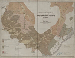
Geognostic Map of the Localities of Irkutsk, Verkholensk, and Balagansk Districts, 1873. The first geological (geognostic) maps in Russia were produced in the 1850s
Projecting Plan of a District City Tomsk, Made in 1872, 1873. Creator: UnknownProjecting Plan of a District City Tomsk, Made in 1872, 1873
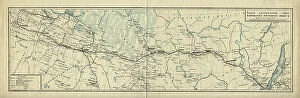
Map of the Route of the Siberian Railway Line, 1891-1916.. Creator: UnknownMap of the Route of the Siberian Railway Line, 1891-1916
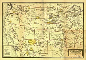
Indian Reservations west of the Mississippi River, 1923. Creator: Office of Indian AffairsIndian Reservations west of the Mississippi River, 1923. This map, created by the Office of Indian Affairs in 1923, shows the location of Indian reservations west of the Mississippi River
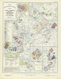
Extraction and primary processing of non-metallic minerals as of January 1, 1933, 1934. From the atlas "Industry of the USSR at the beginning of the 2nd Five-Year Plan
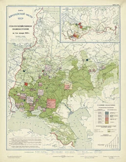
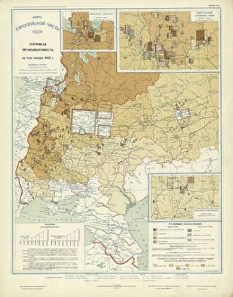
Agricultural engineering as of January 1, 1933, 1934. Creator: Mikhail Alekseevich TSvetkovAgricultural engineering as of January 1, 1933, 1934. From the atlas "Industry of the USSR at the beginning of the 2nd Five-Year Plan
Automotive and tractor manufacturing on January 1, 1933, 1934. Creator: Mikhail Alekseevich TSvetkovAutomotive and tractor manufacturing on January 1, 1933, 1934. From the atlas "Industry of the USSR at the beginning of the 2nd Five-Year Plan
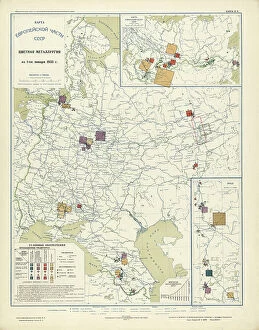
Non-ferrous metallurgy on January 1, 1933, 1934. Creator: Mikhail Alekseevich TSvetkovNon-ferrous metallurgy on January 1, 1933, 1934. From the atlas "Industry of the USSR at the beginning of the 2nd Five-Year Plan
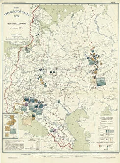
Ferrous metallurgy on January 1, 1933, 1934. Creator: Mikhail Alekseevich TSvetkovFerrous metallurgy on January 1, 1933, 1934. From the atlas "Industry of the USSR at the beginning of the 2nd Five-Year Plan
Peat industry on January 1, 1933, 1934. Creator: Mikhail Alekseevich TSvetkovPeat industry on January 1, 1933, 1934. From the atlas "Industry of the USSR at the beginning of the 2nd Five-Year Plan
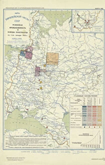
Coal industry on January 1, 1933, 1934. Creator: Mikhail Alekseevich TSvetkovCoal industry on January 1, 1933, 1934. From the atlas "Industry of the USSR at the beginning of the 2nd Five-Year Plan
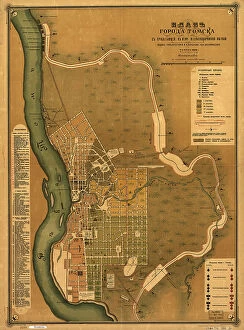
Plan goroda Tomskas prilegai?u?shchei? k nemu zheli?e?znodorozhnoi? vi?e?tv'i?u?, 1898. Creators: M. NPlan goroda Tomskas prilegai?u?shchei? k nemu zheli?e?znodorozhnoi? vi?e?tv'i?u?, 1898. Scale 1:16, 800; Relief shown by land form drawings. Russian. Shows wards and fire districts
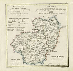
General Map of Kaluga Province: Showing Postal and Major Roads, Stations and... 1822General Map of Kaluga Province: Showing Postal and Major Roads, Stations and the Distance in Versts between Them, 1822. This 1822 map of Kaluga Province is from a larger work
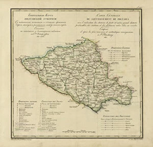
General Map of Poltava Province: Showing Postal and Major Roads, Stations and... 1821General Map of Poltava Province: Showing Postal and Major Roads, Stations and the Distance in Versts between Them, 1821. This 1821 map of Poltava Provinceis from a larger work
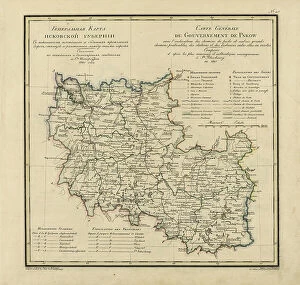
General Map of Pskov Province: Showing Postal and Major Roads, Stations and the Distance... 1820General Map of Pskov Province: Showing Postal and Major Roads, Stations and the Distance in Versts between Them, 1820. This 1820 map of Pskov Provinceis from a larger work
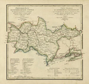
General Map of Ekaterinoslav Province: Showing Postal and Major Roads, Stations and the... 1821General Map of Ekaterinoslav Province: Showing Postal and Major Roads, Stations and the Distance in Versts between Them, 1821
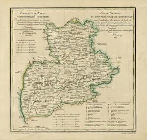
General Map of Chernigov Province: Showing Postal and Major Roads, Stations and... 1821General Map of Chernigov Province: Showing Postal and Major Roads, Stations and the Distance in Versts between Them, 1821
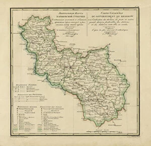
General Map of Kharkiv Province: Showing Postal and Major Roads, Stations and the... 1821General Map of Kharkiv Province: Showing Postal and Major Roads, Stations and the Distance in Versts between Them, 1821. This 1821 map of Kharkiv Provinceis from a larger work
General Map of Vladimir Province: Showing Postal and Major Roads, Stations and the... 1822General Map of Vladimir Province: Showing Postal and Major Roads, Stations and the Distance in Versts between Them, 1822. This 1822 map of Vladimir Provinceis from a larger work
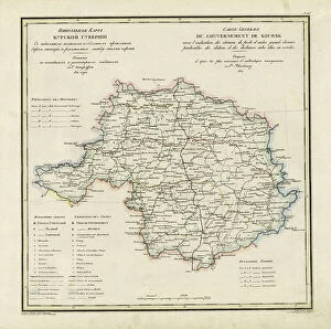
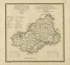
General Map of Kursk Province: Showing Postal and Major Roads, Stations and the... 1822General Map of Kursk Province: Showing Postal and Major Roads, Stations and the Distance in Versts between Them, 1822. This 1822 map of Kursk Provinceis from a larger work
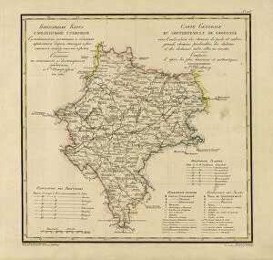
General Map of Moscow Province: Showing Postal and Major Roads, Stations and the.. 1821General Map of Moscow Province: Showing Postal and Major Roads, Stations and the Distance in Versts between Them, 1821. This 1821 map of Smolensk Provinceis from a larger work
General Map of Tver Province: Showing Postal and Major Roads, Stations and the... 1821General Map of Tver Province: Showing Postal and Major Roads, Stations and the Distance in Versts between Them, 1821. This 1821 map of Tver Provinceis from a larger work
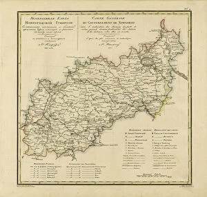
General Map of Novgorod Province: Showing Postal and Major Roads, Stations and the... 1821General Map of Novgorod Province: Showing Postal and Major Roads, Stations and the Distance in Versts between Them, 1821. This 1821 map of Novgorod Provinceis from a larger work
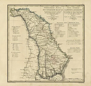
General Map of Bessarabia: Showing Postal and Major Roads, Stations and the... 1821General Map of Bessarabia: Showing Postal and Major Roads, Stations and the Distance in Versts between Them, 1821. This 1821 map of Bessarabia is from a larger work
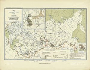
The Five-Year Plan of New Construction of Industry of the USSR: Map of the Asiatic Part... 1930 Creator: I. AThe Five-Year Plan of New Construction of Industry of the USSR: Map of the Asiatic Part of the USSR, 1930. Supplement to the map of the Five-Year plan of the European part of the USSR