mail_outline sales@mediastorehouse.com
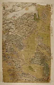
The Selden Map of China. Artist: Chinese MasterThe Selden Map of China. Found in the collection of the Bodleian Library, Oxford
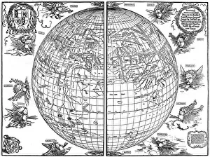
Johannes Stabius map of the world, 1515, (1936). Artist: Albrecht DurerJohannes Stabius map of the world, 1515, (1936). A print from Durer, Und Seine Zeit, by Wilhelm Waetzoldt, Grosse Phaidon Ausgabe, 1936
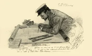
A Hansen, first officer on the Knivsberg, 1898. Creator: Christian Wilhelm AllersA Hansen, first officer on the Knivsberg, 1898. Portrait of a German crew member using compasses and parallel rulers to plot the course of the SS Knivsberg through the South China Sea
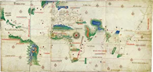
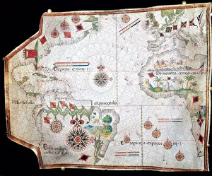
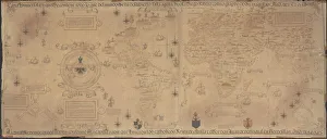
The Cantino planisphere, 1502. Artist: Anonymous masterThe Cantino planisphere, 1502. Found in the collection of the Biblioteca Estense Universitaria, Modena
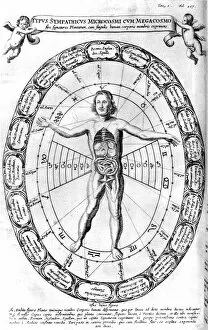
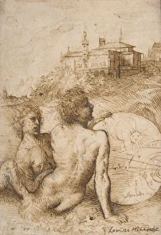
Influence of the Universe, the Macrocosm, on Man, the Microcosm, 1678. From Mundus Subterraneus by Athanasius Kircher. (Amsterdam, 1678)
Map of Magellans round the world voyage, 1519-1521. A Portuguese-born navigator sponsored by Spain, Ferdinand Magellan (c1480-1521)
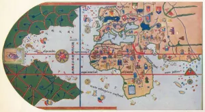
Map of Britain and Ireland, 10th century AH/AD 16th century. Creator: UnknownMap of Britain and Ireland, 10th century AH/AD 16th century. Page from an early Ottoman illuminated and illustrated maritime atlas, referred to as the Walters Deniz atlasi
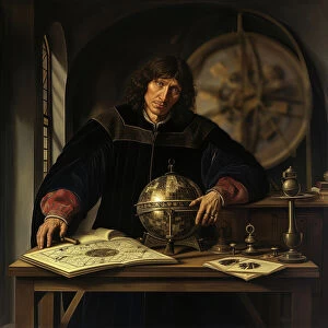
AI IMAGE - Portrait of Nicolaus Copernicus, early 16th century, (2023). Creator: Heritage ImagesAI IMAGE - Portrait of Nicolaus Copernicus, early 16th century, (2023). Copernicus (1473-1543) was a Polish Renaissance polymath, active as a mathematician, astronomer, and Catholic canon
The North West Passage, after John Everett Millais, Esq. R.A. 1874. c1880-83. Creator: A Mongin'The North West Passage, after John Everett Millais, Esq. R.A. 1874. From "Modern Artists" by F.G.Dumas. [J.S.Virtue & Co Ltd, London, c1880]
Bid Board Office of Supplies & Accounts Navy Dept, between 1915 and 1920. Creator: Harris & EwingBid Board Office of Supplies & Accounts Navy Dept, between 1915 and 1920. USA. Graph with prices in pounds and hundredweights for Pittsburgh steel in sheet, galvanised and bar form
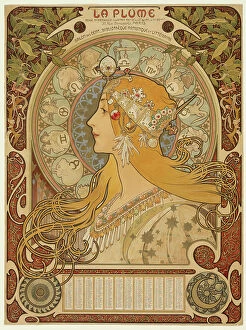
Zodiaque ("La Plume"), 1896-97. Creator: Alphonse Mucha. Zodiaque ("La Plume"), 1896-97Zodiaque ("La Plume"), 1896-97
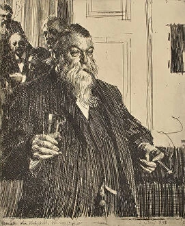
Portrait, 1893. Creator: Anders Leonard ZornPortrait, 1893. Gentleman in full beard, fitted with cigar and goggles. In the background four more gentlemen can be seen in the adjoining room
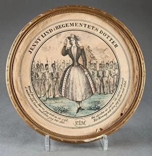
Jenny Lind in The Regiment's Daughter, (c1850s). Creator: UnknownJenny Lind in The Regiment's Daughter, (c1850s)
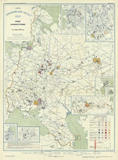
General mechanical engineering on January 1, 1933, 1934. Creator: Mikhail Alekseevich TSvetkovGeneral mechanical engineering on January 1, 1933, 1934. From the atlas "Industry of the USSR at the beginning of the 2nd Five-Year Plan
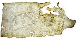
Carta Pisana, ca 1275-1300. Artist: Anonymous masterCarta Pisana, ca 1275-1300. Found in the collection of the Bibliotheque Nationale de France
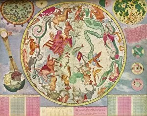
Star Chart for the Southern Hemisphere, End of the Year 1700, c1700, (1936). Artist: Carel AllardStar Chart for the Southern Hemisphere, End of the Year 1700, c1700, (1936). Made and published by C. Allard, Amsterdam. From The Connoisseur, Vol. 98, edited by H. Granville Fell
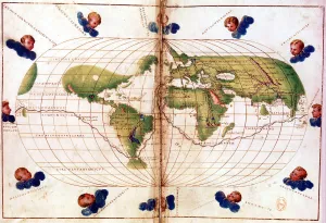
The First map to Show America, (1500) 1912The First map to Show America, 1500 (1912). After the map of Juan de la Cosa (c1450-1510), 1500. The map or chart is a mappa mundi painted on parchment
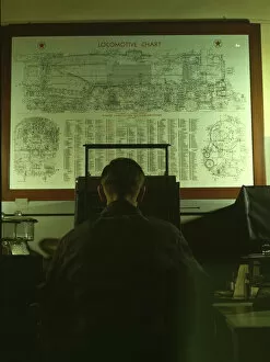
Locomotive lubrication chart in the laboratory of the C & NW R s, Chicago, Ill, 1942. Creator: Jack DelanoLocomotive lubrication chart in the laboratory of the Chicago and Northwestern [i.e. North Western] Railroad. The laboratory assistant in foreground is working at a precision balance. Chicago, Ill
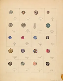
Buttons, c. 1937. Creator: Gertrude LembergButtons, c. 1937
Captain Charles Stewart, 1811-1812. Creator: Thomas SullyCaptain Charles Stewart, 1811-1812
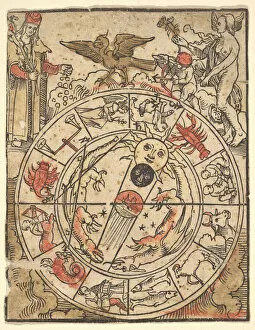
Chart of the Signs of the Zodiac with Venus, Cupid, and a Bishop Saint
Two Satyrs in a Landscape, ca. 1505-10. Creator: TitianTwo Satyrs in a Landscape, ca. 1505-10
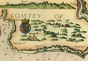
Chart showing windmills as landmarks on the north-east coast of England, 1588, (1947). Places marked include Hartlepool, Easington and Sunderland
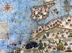
Portolan chart of the Mediterranean Sea, the Black Sea, Sea of Azov…, 16th centuryPortolan chart of the Mediterranean Sea, the Black Sea, Sea of Azov and Atlantic coasts of Europe and Africa, 16th century. Found in the Collection of Biblioteca Nacional, Madrid
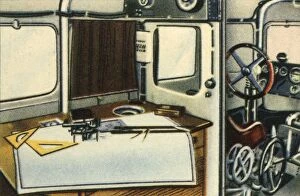
Dornier Do X flying boat navigation room, 1920s, (1932). Creator: UnknownDornier Do X flying boat navigation room, 1920s, (1932). Interior of the German Dornier Do X, the largest, heaviest, and most powerful flying boat in the world when it was produced by the Dornier
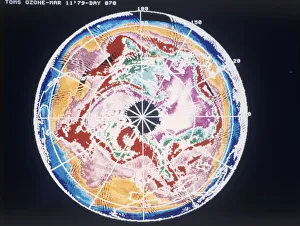
North Pole total ozone maps with meteorological chart, March 1979. Creator: NASANorth Pole total ozone maps with meteorological chart, March 1979
Nautical world map. (Australia is suggested but still unknown territory and, California is shown as an island), 1634. Found in the Collection of Bibliothe que Nationale de France
Control Centre of the Empress of Britain, chart-room and wheel-house, 1936The Control Centre of the Empress of Britain, comprises the chart-room and the wheel-house, 1936. From Shipping Wonders of the World, Vol. 1, edited by Clarence Winchester
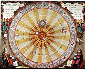
Planisphere by Copernicus, illustration in Harmonia Macrocosmica, 1660 by Andreas Cellarius
Catalan Atlas (1375). Detail of Spain and North Africa. Reproduction of the original which is located in the National Library in Paris
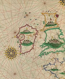
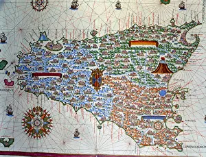
Atlas of Joan Martines, Messina, 1582. Portulan chart of the island of Sicily
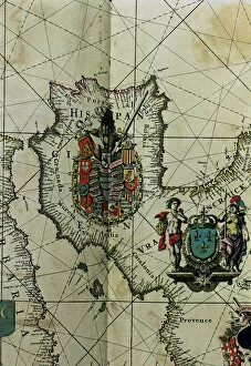
Map of Spain with all their kingdoms, Portugal and the Country of Llenguadoc. Atlas by Frederick de Witt
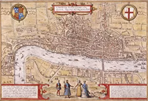
Map of the City of London, Southwark and part of Westminster, 1572
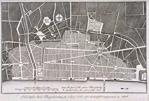
Proposed plan for the rebuilding of the City of London after the Great Fire in 1666
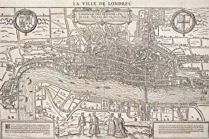
Map of the City of London and City of Westminster with four figures in the foreground, (c1572?). Heraldic shield on left depicts the Tudor royal arms and shield on left depicts the City of London arms
Victory at Pyongyang Castle, 1894Victory at Pyongyang Castle, pub. 1894 (colour woodcut)
Nautical chart, 1558. Found in the collection of British Museum
Nautical chart of the Mediterranean Sea, 1508. Found in the collection of Museo Maritimo, Barcelona
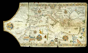
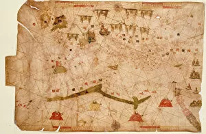
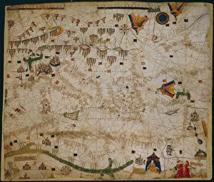
Nautical chart of the Mediterranean Sea and the Black Sea, 1440s. Artist: Rossell (Rosselli)Nautical chart of the Mediterranean Sea and the Black Sea, 1440s. Found in the collection of the Bibliotheque Nationale de France
World Map (Propoganda), 1529. Artist: Ribeiro, Diogo (?-1533)World Map (Propoganda), 1529. Found in the collection of the Biblioteca Apostolica Vaticana
Land! Land! Land!, Columbus arriving in America, 1492 (late 19th or early 20th century)Land! Land! Land!, Christopher Columbus arriving in America, 1492 (late 19th or early 20th century). Sponsored by Ferdinand and Isabella of Spain
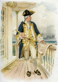
Admiral, 18th century (c1890-c1893). A print from Her Majestys Navy Including its Deeds and Battles, by Lieut Chas Rathbone Low, Volume I, JS Virtue & Co, London, 1890-1893
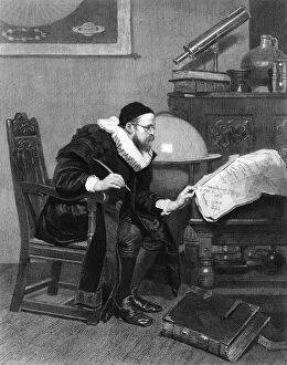
The Astrologer, c19th century. Artist: J DemannezThe Astrologer, c19th century. A Victorian view of a 16th-century practitioner of astrology
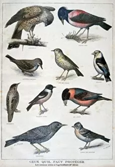
Birds that are protected, and helpful in agriculture, 1897. Artist: F MeaulleBirds that are protected, and helpful in agriculture, 1897. An illustration from Le Petit Journal, 31st January 1897
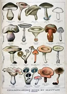
Good and bad mushrooms, 1896. An illustration from Le Petit Journal, 25th October 1896
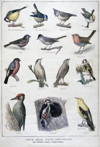
Useful birds in agriculture, 1896. Artist: A ClementUseful birds in agriculture, 1896. An illustration from Le Petit Journal, 13th December 1896
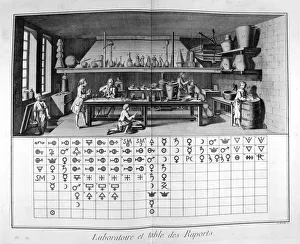
Laboratory and chart, 1751-1777. A print from the Encyclopedie, ou Dictionnaire Raisonne des Sciences, des Arts et des Metiers by Diderot & d Alembert, 1751-1777. Private Collection
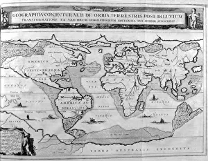
Geographic chart of the world after the deluge, 1675. Artist: Athanasius KircherGeographic chart of the world after the deluge, 1675. A print from Arca Noe, Amsterdam, 1675. Found in the collection of Jean Claude Carriere