mail_outline sales@mediastorehouse.com
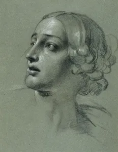
Head study for "Arindal and Daura", around 1820/1855. Creator: Johann Peter KrafftHead study for "Arindal and Daura", around 1820/1855
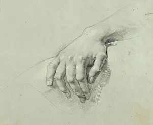
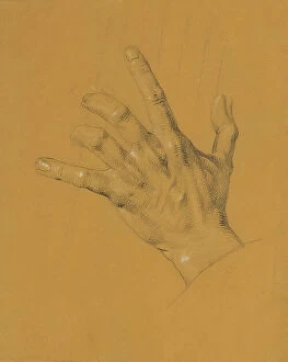
Hand study for "Arindal and Daura", around 1820/1855. Creator: Johann Peter KrafftHand study for "Arindal and Daura", around 1820/1855
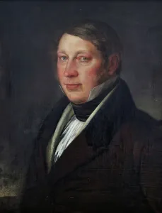
Wholesaler Gustaf Adolf Elfstrand, c1820s) Creator: Per Krafft the YoungerWholesaler Gustaf Adolf Elfstrand, (c1820s)
Michael Benedicks, 1822. Creator: Fredric WestinMichael Benedicks, 1822
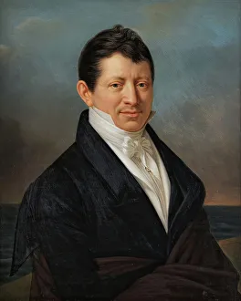
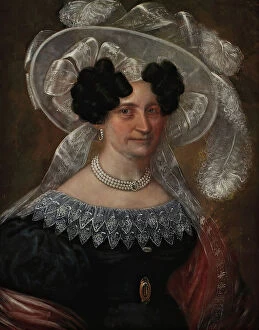
Portrait of B.C. Rettig, b. Jaderholm, (c1820s). Creator: Carl Peter LehmannPortrait of B.C. Rettig, b. Jaderholm, (c1820s)
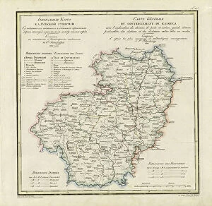
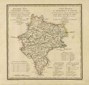
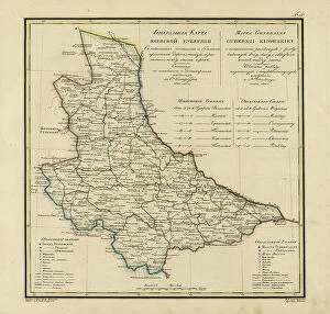
General Map of Kaluga Province: Showing Postal and Major Roads, Stations and... 1822General Map of Kaluga Province: Showing Postal and Major Roads, Stations and the Distance in Versts between Them, 1822. This 1822 map of Kaluga Province is from a larger work
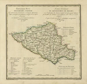
General Map of Poltava Province: Showing Postal and Major Roads, Stations and... 1821General Map of Poltava Province: Showing Postal and Major Roads, Stations and the Distance in Versts between Them, 1821. This 1821 map of Poltava Provinceis from a larger work
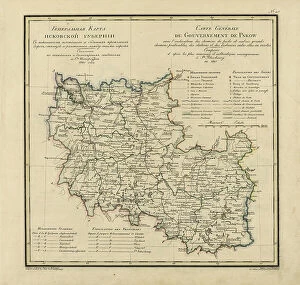
General Map of Pskov Province: Showing Postal and Major Roads, Stations and the Distance... 1820General Map of Pskov Province: Showing Postal and Major Roads, Stations and the Distance in Versts between Them, 1820. This 1820 map of Pskov Provinceis from a larger work
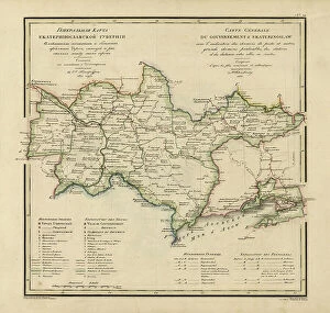
General Map of Ekaterinoslav Province: Showing Postal and Major Roads, Stations and the... 1821General Map of Ekaterinoslav Province: Showing Postal and Major Roads, Stations and the Distance in Versts between Them, 1821
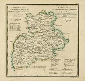
General Map of Chernigov Province: Showing Postal and Major Roads, Stations and... 1821General Map of Chernigov Province: Showing Postal and Major Roads, Stations and the Distance in Versts between Them, 1821
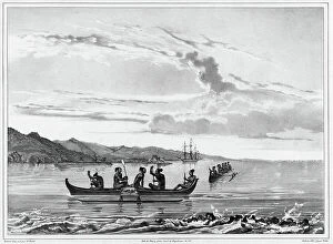
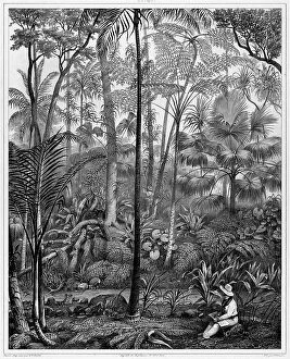
View Taken in the Woods, Guam Island, Mariana Islands, 19th century. Creators: Alexander Postels, Godefroy EngelmannView Taken in the Woods, Guam Island, Mariana Islands, 19th century. One of 65 lithographs that were included in the volume of maps published after the round-the-world voyage of the corvette Seniavin
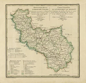
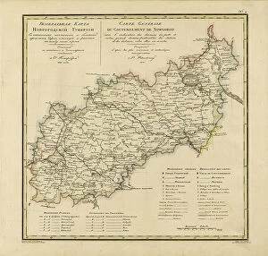
General Map of Kharkiv Province: Showing Postal and Major Roads, Stations and the... 1821General Map of Kharkiv Province: Showing Postal and Major Roads, Stations and the Distance in Versts between Them, 1821. This 1821 map of Kharkiv Provinceis from a larger work
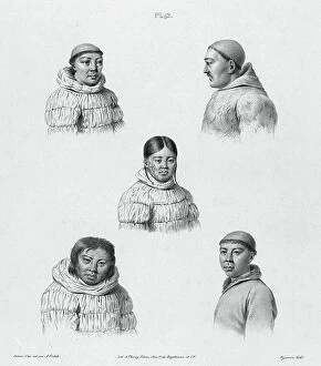
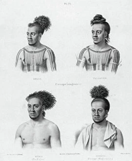
Inhabitants of the Country of the Chukchis, Northeast Coast of Asia, 19th century. One of 65 lithographs that were included in the volume of maps published after the round-the-world voyage of
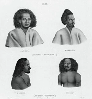
Inhabitants of the lower Caroline Islands, 19th century. Creators: Alexander Postels, Godefroy EngelmannInhabitants of the lower Caroline Islands, 19th century. One of 65 lithographs that were included in the volume of maps published after the round-the-world voyage of the corvette Seniavin
General Map of Vladimir Province: Showing Postal and Major Roads, Stations and the... 1822General Map of Vladimir Province: Showing Postal and Major Roads, Stations and the Distance in Versts between Them, 1822. This 1822 map of Vladimir Provinceis from a larger work
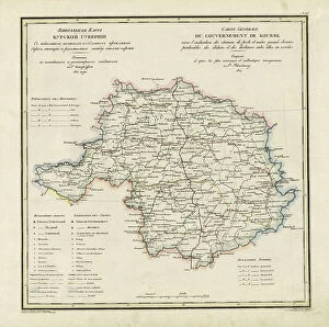
General Map of Kursk Province: Showing Postal and Major Roads, Stations and the... 1822General Map of Kursk Province: Showing Postal and Major Roads, Stations and the Distance in Versts between Them, 1822. This 1822 map of Kursk Provinceis from a larger work
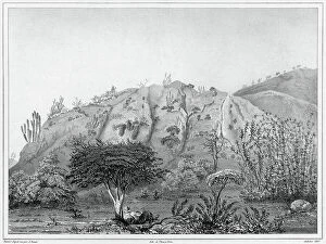
View Taken in the Forests of Peel Island, Bonin Islands, 19th century. Creators: Alexander Postels, Godefroy EngelmannView Taken in the Forests of Peel Island, Bonin Islands, 19th century. One of 65 lithographs that were included in the volume of maps published after the round-the-world voyage of the corvette
General Map of Moscow Province: Showing Postal and Major Roads, Stations and the.. 1821General Map of Moscow Province: Showing Postal and Major Roads, Stations and the Distance in Versts between Them, 1821. This 1821 map of Smolensk Provinceis from a larger work
View of the Outskirts of Valparaiso, Chile, 19th century. Creators: Alexander Postels, Leon Jean-Baptiste SabatierView of the Outskirts of Valparaiso, Chile, 19th century. One of 65 lithographs that were included in the volume of maps published after the round-the-world voyage of the corvette Seniavin
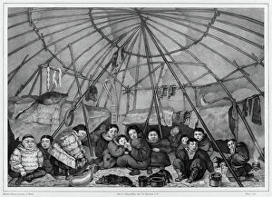
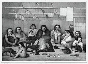
Interior of a Chukchi Hut, Northeast Coast of Asia, 19th century. Creators: Alexander Postels, Godefroy EngelmannInterior of a Chukchi Hut, Northeast Coast of Asia, 19th century. One of 65 lithographs that were included in the volume of maps published after the round-the-world voyage of the corvette Seniavin
Interior of a clochan hut (Sitka island, north coast of America), 19th century. One of 65 lithographs that were included in the volume of maps published after the round-the-world voyage of
General Map of Tver Province: Showing Postal and Major Roads, Stations and the... 1821General Map of Tver Province: Showing Postal and Major Roads, Stations and the Distance in Versts between Them, 1821. This 1821 map of Tver Provinceis from a larger work
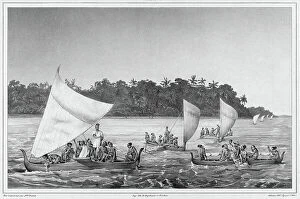
Navigation, Lower Caroline Islands, Lukunor Group, 19th century. Creators: Alexander Postels, Victor AdamNavigation, Lower Caroline Islands, Lukunor Group, 19th century. One of 65 lithographs that were included in the volume of maps published after the round-the-world voyage of the corvette Seniavin
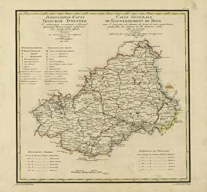
General Map of Novgorod Province: Showing Postal and Major Roads, Stations and the... 1821General Map of Novgorod Province: Showing Postal and Major Roads, Stations and the Distance in Versts between Them, 1821. This 1821 map of Novgorod Provinceis from a larger work
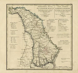
General Map of Bessarabia: Showing Postal and Major Roads, Stations and the... 1821General Map of Bessarabia: Showing Postal and Major Roads, Stations and the Distance in Versts between Them, 1821. This 1821 map of Bessarabia is from a larger work
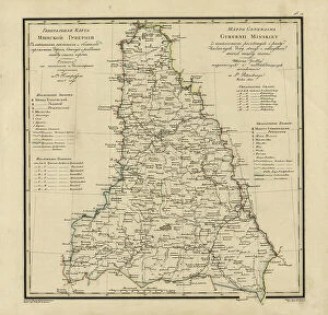
General Map of Minsk Province: Showing Postal and Major Roads, Stations and the... 1821General Map of Minsk Province: Showing Postal and Major Roads, Stations and the Distance in Versts between Them, 1821. This 1821 map of Minsk Province is from a larger work
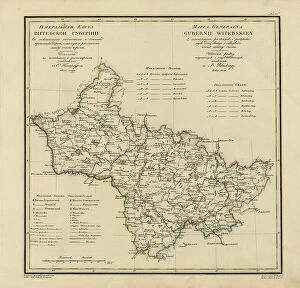
General Map of Vitebsk Province: Showing Postal and Major Roads, Stations and the... 1820General Map of Vitebsk Province: Showing Postal and Major Roads, Stations and the Distance in Versts between Them, 1820. This 1820 map of Vitebsk Provinceis from a larger work
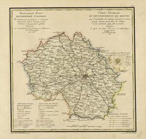
General Map of Moscow Province: Showing Postal and Major Roads, Stations and... 1821General Map of Moscow Province: Showing Postal and Major Roads, Stations and the Distance in Versts between Them, 1821. This 1821 map of Moscow Province is from a larger work
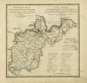
General Map of Saint Petersburg Province: Showing Postal and Major Roads, Stations and the... 1820General Map of Saint Petersburg Province: Showing Postal and Major Roads, Stations and the Distance in Versts between Them, 1820
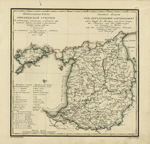
General Map of Livland Province: Showing Postal and Major Roads, Stations and the... 1820General Map of Livland Province: Showing Postal and Major Roads, Stations and the Distance in Versts between Them, 1820. This 1820 map of Livland Provinceis from a larger work
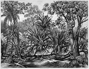
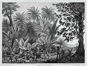
View Taken in the Forests of Guam Island, Mariana Islands, 19th century. Creators: Alexander PostelsView Taken in the Forests of Guam Island, Mariana Islands, 19th century. One of 65 lithographs that were included in the volume of maps published after the round-the-world voyage of the corvette
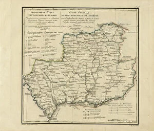
General Map of Kherson Province: Showing Postal and Major Roads, Stations and... 1821General Map of Kherson Province: Showing Postal and Major Roads, Stations and the Distance in Versts between Them, 1821. This 1821 map of Kherson Provinceis from a larger work
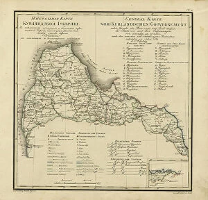
General Map of Courland Province: Showing Postal and Major Roads, Stations and the... 1820General Map of Courland Province: Showing Postal and Major Roads, Stations and the Distance in Versts between Them, 1820. This 1820 map of Courland Province is from a larger work
General Map of Kiev Province: Showing Postal and Major Roads, Stations and.. 1821General Map of Kiev Province: Showing Postal and Major Roads, Stations and the Distance in Versts between Them, 1821. This 1821 map of Kiev Province is from a larger work
View of the Port of La Coquille In Kosrae Island, Caroline Islands, 19th century. One of 65 lithographs that were included in the volume of maps published after the round-the-world voyage of
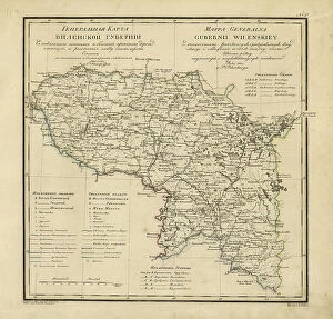
General Map of Vilnius Province: Showing Postal and Major Roads, Stations and the... 1820General Map of Vilnius Province: Showing Postal and Major Roads, Stations and the Distance in Versts between Them, 1820. This 1820 map of Vilnius Provinceis from a larger work
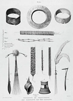
Ornaments and instruments of the inhabitants of the Caroline Islands, 19th century. One of 65 lithographs that were included in the volume of maps published after the round-the-world voyage of
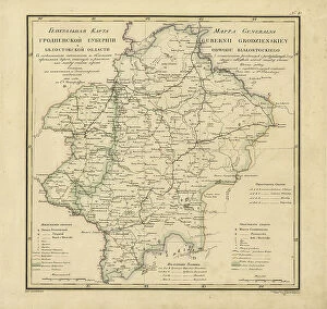
General Map of Grodno Province and the Belostok Region: Showing Postal and Major Roads... 1820General Map of Grodno Province and the Belostok Region: Showing Postal and Major Roads, Stations and the Distance in Versts between Them, 1820
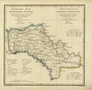
General Map of Podolsk Province: Showing Postal and Major Roads, Stations and the... 1820General Map of Podolsk Province: Showing Postal and Major Roads, Stations and the Distance in Versts between Them, 1820. This 1820 map of Podolsk Provinceis from a larger work
View Taken in the Woods, Bonin Islands, 19th century. Creators: Alexander Postels, Godefroy EngelmannView Taken in the Woods, Bonin Islands, 19th century. One of 65 lithographs that were included in the volume of maps published after the round-the-world voyage of the corvette Seniavin commissioned
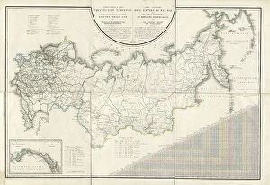
General Map of the Russian Empire and the Neighboring Polish.. 1827. Creators: Vasilii Petrovich Piadyshev, IereminGeneral Map of the Russian Empire and the Neighboring Polish Empire and Grand Duchy of Finland: With the Distance in Versts on Postal Roads between Provincial Cities;
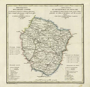
General Map of Yaroslavl Province: Showing Postal and Major Roads, Stations and the... 1822General Map of Yaroslavl Province: Showing Postal and Major Roads, Stations and the Distance in Versts between Them, 1822
View of Lukunor Island, Lower Caroline Islands, 19th century. Creators: Alexander Postels, Godefroy EngelmannView of Lukunor Island, Lower Caroline Islands, 19th century. One of 65 lithographs that were included in the volume of maps published after the round-the-world voyage of the corvette Seniavin
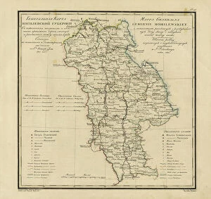
General Map of Mogilev Province: Showing Postal and Major Roads, Stations and... 1821General Map of Mogilev Province: Showing Postal and Major Roads, Stations and the Distance in Versts between Them, 1821. This 1821 map of Mogilev Provinceis from a larger work
Hand study for "Ossian and Malvina", before 1821. Creator: Johann Peter KrafftHand study for "Ossian and Malvina", before 1821