mail_outline sales@mediastorehouse.com
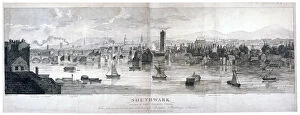
Southwark, London, 1807. Panoramic view of Southwark with St Georges Fields and part of Lambeth, from an elevated position at the back of Beaufort Buildings, Strand
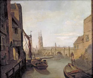
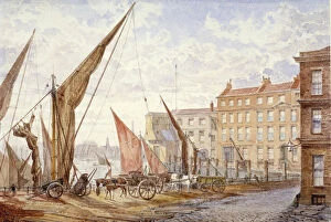
London Bridge from Pepper Alley Stairs, 1788
Near Brewers Quay, c1930. Artist: Samuel Harry HancockNear Brewers Quay, c1930. View showing figures on barges in the foreground and Tower Bridge in the distance
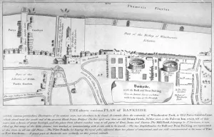
Plan of Bankside, Southwark, London, c1570. Showing the arenas for bull and bear baiting, the pike gardens and Winchester Park
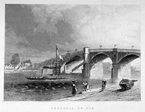
View of Vauxhall Bridge with a steamboat on the Thames, London, c1847
View of a sand vessel on the River Thames at Vauxhall, London, c1820
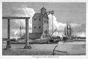
Brunswick Dock, Blackwall, London, c1800. View with Perrys Mast House which held a crane for raising or fitting masts to ships
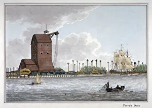
Brunswick Dock, Blackwall, London, 1801. Artist: Charles TomkinsBrunswick Dock, Blackwall, London, 1801. View with the Perrys Mast House on the left, which held a crane for raising or fitting masts to ships
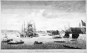
Blackwall, Poplar, London, 1750. Artist: John BoydellBlackwall, Poplar, London, 1750. View of Blackwall, looking towards Greenwich, with ships, boats and barges on the Thames
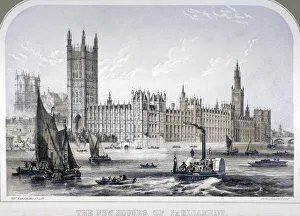
Palace of Westminster, London, c1860. Artist: Roberts GroomPalace of Westminster, London, c1860. View of the Palace of Westminster from the River Thames showing sailing boats, steam boats and rowing boats
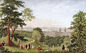
Greenwich Park, Greenwich, London, c1840. View of London from Greenwich Park, with the River Thames and Greenwich Hospital in the middle distance and figures in the foreground
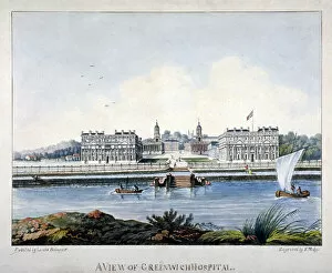
View of Greenwich Hospital from the Isle of Dogs, London, c1800. Artist:s MalgoView of Greenwich Hospital from the Isle of Dogs, London, c1800
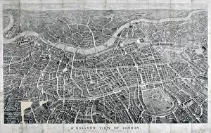
View of London from the north as seen from a balloon, 1851
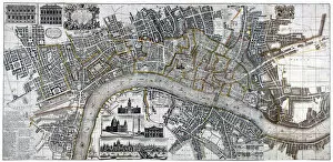
Map of the City of London, City of Westminster, River Thames, Lambeth and Southwark, 1736. Top left shows two elevations of Banqueting House and Treasury
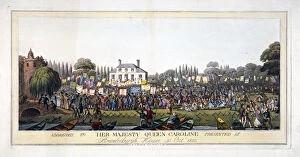
Brandenburgh House, Hammersmith, London, 1820 (1821). View of Brandenburgh House during the addresses declaring loyalty to Queen Caroline during the governmental attempts to deprive her of her title
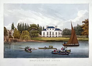
Brandenburgh House, Hammersmith, London, 1820. Artist: F VincentBrandenburgh House, Hammersmith, London, 1820. View of the house with water craft on the River Thames
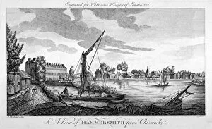
View of Hammersmith from Chiswick, London, c1770. Artist: John RoyceView of Hammersmith from Chiswick, London, c1770. View showing the River Thames and boats in the foreground
Plan of the fire that took place at Ratcliff in Stepney, London, in 1794. ArtistPlan of the fire that took place at Ratcliff in Stepney, London, in 1794. The area was devastated by the worst of many fires which constantly swept through the riverside hamlet
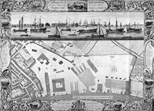
Deptford Docks, London, 1753. ArtistDeptford Docks, London, 1753. Plan of the Dock Yard at Deptford including the surrounding area. In the upper section is a view of the River Thames with water vessels
Cheyne Walk, Chelsea, London, c1846. ArtistCheyne Walk, Chelsea, London, c1846. Design for the improvement of Cheyne Walk, Chelsea, from Oakley Street to Battersea Bridge
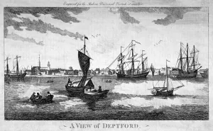
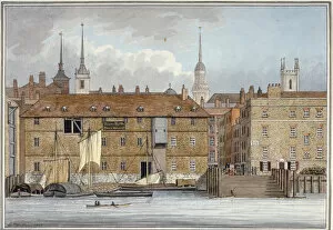
View of Deptford across the River Thames, London, c1790. ArtistView of Deptford across the River Thames, London, c1790
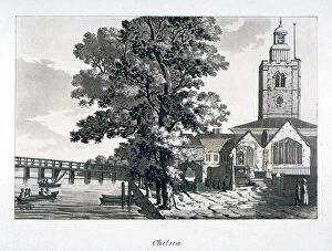
View of Chelsea Old Church with the River Thames on the left, London, c1800
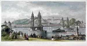
View of the suspension bridge at Chelsea, London, 1852. In the foreground figures watch water vessels passing underneath the bridge
View of the Adam and Eve Inn, Chelsea, London, c1900
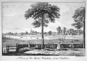
View of the River Thames from Chelsea, London, 1750. In the foreground a woman guides a child along the top of a wall
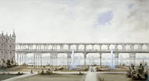
Temple Gardens, City of London, c1840. ArtistTemple Gardens, City of London, c1840. Proposal for a covered riverside promenade in the Temple Gardens which would leave the gardens open to the Thames
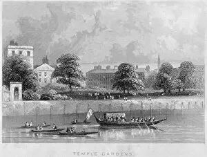
View of Temple Gardens from the Thames with boats on the river, City of London, c1850
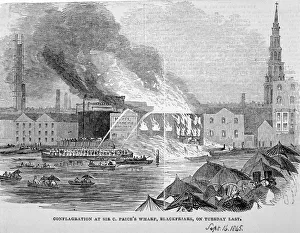
Destruction of Sir C Prices oil warehouse and wharf, William Street, Blackfriars, London, 1845. In the foreground figures stand sheltering under umbrellas watching the event
Panorama of London, 1616. Artist: ClaesPanorama of London, 1616. Panoramic view of London from the South Bank looking across the River Thames towards the Tower of London
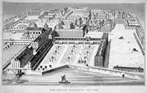
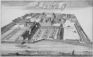
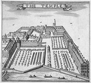
Inner and Middle Temple, City of London, 1720. Birds eye view of Inner Temple and Middle Temple showing their proximity to the River Thames
Inner and Middle Temple, City of London, 1700. Birds eye view of Inner Temple and Middle Temple showing their proximity to the River Thames
Temple, City of London, 1750. ArtistTemple, City of London, 1750. Birds eye view of Inner Temple and Middle Temple showing their proximity to the River Thames
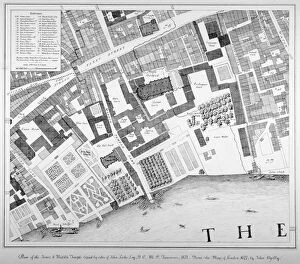
Middle and Inner Temple, City of London, 1871. ArtistMiddle and Inner Temple, City of London, 1871. Plan of Middle Temple and Inner Temple showing their proximity to the River Thames
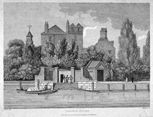
Temple Stairs, Middle Temple Lane, City of London, 1801. ArtistTemple Stairs, Middle Temple Lane, City of London, 1801. View of Temple Stairs, with boats on the River Thames and figures on the riverbank
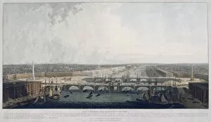
Proposed London Bridge, London, 1802. ArtistProposed London Bridge, London, 1802. View of the proposed improvements to the Port of London showing George Dances proposed double bridge as a replacement to the old London Bridge
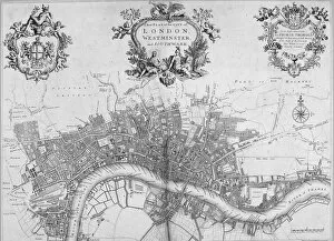
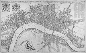
Map of Westminster, the City of London and Southwark, 1720. With the City arms in an ornamental cartouche with Mercury, the title in an ornamental cartouche with Victory, Appollo and Athena
View of Maidstone Wharf, Queenhithe, City of London, 1865. Artist: Alfred SlocombeView of Maidstone Wharf, Queenhithe, City of London, 1865
Queenhithe flour wharf, City of London, 1801. Artist: Charles TomkinsQueenhithe flour wharf, City of London, 1801
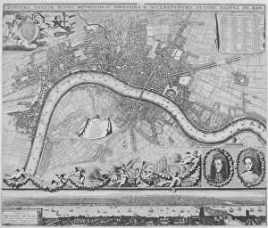
Map of London, 1690. Artist: Johannes de RamMap of London, 1690 Map with a panorama in the lower margin, portraits of William III and Mary II and putti carrying various devices including the City of London and Royal arms
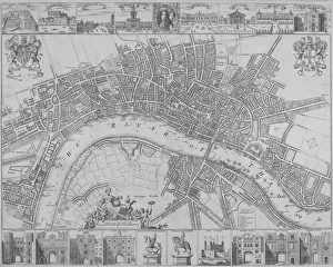
Map of the Cities of London and Westminster, Southwark and the suburbs, 1680. ArtistMap of the Cities of London and Westminster, Southwark and the suburbs, 1680. With the royal arms at top left, a key top right and a female figure holding dividers seated above the scale
Map of the Cities of London and Westminster and Southwark, 1690. With views of buildings and portraits of William III and Mary II in an oval in the top margin and gates
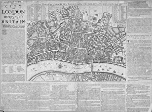
Map of the City of London surrounded by descriptive text, 1676
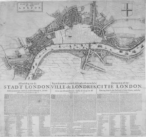
Map of London showing the destruction caused by the Great Fire, 1666. With a description in Dutch, French and English below
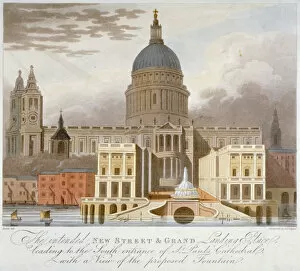
Proposed riverfront access to St Pauls Cathedral, City of London, 1826. ArtistProposed riverfront access to St Pauls Cathedral, City of London, 1826. Proposal for a new street and ground landing place, with fountain, leading to the south entrance of the cathedral
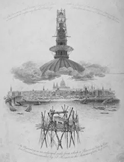
St Pauls Cathedral, City of London, 1822. Artist: Samuel RawleSt Pauls Cathedral, City of London, 1822. The top and bottom images show an observatory erected over the cross of the cathedral
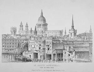
St Pauls Cathedral from Southwark Bridge, City of London, 1835. View with wharves in the foreground and signs for Bull Wharf, RW Kennard, Iron Wharf and W and F White, Kennet Wharf
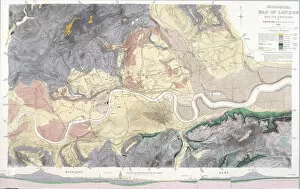
Geological map of London and the surrounding area, 1871. Artist: T WalshGeological map of London and the surrounding area, 1871. Map with geological information shown in colours and a vertical scale in the bottom margin
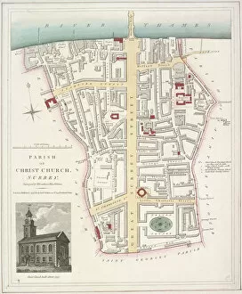
Map of the Parish of Christ Church in Southwark, London, 1821. With an image of the church inset in the bottom left corner