mail_outline sales@mediastorehouse.com
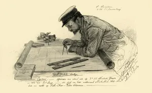
A Hansen, first officer on the Knivsberg, 1898. Creator: Christian Wilhelm AllersA Hansen, first officer on the Knivsberg, 1898. Portrait of a German crew member using compasses and parallel rulers to plot the course of the SS Knivsberg through the South China Sea
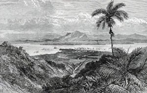
Georgetown, Penang, near Perak, in the Malay Peninsula, 1876. Creator: E. HastieGeorgetown, Penang, near Perak, in the Malay Peninsula, 1876. The nearest British settlement to Perak is that of Pulo Penang, or Prince of Wales's Island
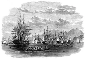
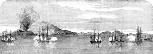
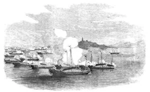
The Combined Fleet in China - transports in Cowloong Bay preparing to get under way for... 1860. Creator: UnknownThe Combined Fleet in China - transports in Cowloong Bay preparing to get under way for the north - from a sketch by our special artist at Hong-Kong, 1860. British warships at anchor
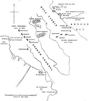
Plan of the Attack on the Forts and Batteries of Canton, Nov.12 and 13, 1856, (1857). Creator: UnknownPlan of the Attack on the Forts and Batteries of Canton, Nov.12 and 13, 1856, (1857). British naval officer:..we have had a job to take some forts called the Bocca Tigris
Chinese Pirate-boat at Canton - from a drawing by a Chinese artist, 1857. Creator: UnknownChinese Pirate-boat at Canton - from a drawing by a Chinese artist, 1857. The river swarms with pirates...and they carry on their depredations unchecked in the very teeth of the forts...The pirate
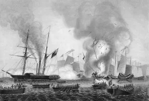
Capture of Bocca Tigris Forts by the English Squadron - the Attack on North and South Wantung, 1857The War with China - Capture of Bocca Tigris Forts by the English Squadron - the Attack on North and South Wantung, 1857. Encounter, North Wantung, Nankin, South Aminghoy, Hornet, South Wantung
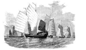
The War in China - Fleet of Chinese Pirates Preparing to Attack, 1857. Creator: UnknownThe War in China - Fleet of Chinese Pirates Preparing to Attack, 1857. One of the greatest evils the merchants commerce of the China Seas has to contend with is the immense number of pirate craft
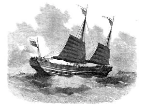
The War in China - Chinese War Junks of the Old Style, 1857. Creator: UnknownThe War in China - Chinese War Junks of the Old Style, 1857. Twenty years ago their ships of war were short, misshapen masses of timber, quaint and ungainly in appearance, almost unmanageable
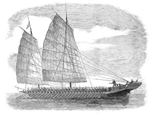
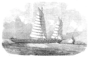
The War in China - Chinese Modern First-Class Junk of War, 1857. Creator: UnknownThe War in China - Chinese Modern First-Class Junk of War, 1857. Second Opium War....the junks of the first class carry guns between decks, like our frigates
The War in China - Chinese Modern Junk of War: Second Class, 1857. Creator: UnknownThe War in China - Chinese Modern Junk of War: Second Class, 1857. Opium Wars....the progress of naval architecture in China has advanced far beyond what the people of that country might have been
Chinese Smuggling Craft, Strait of Formosa, 1857. Creator: UnknownChinese Smuggling Craft, Strait of Formosa, 1857. Ship in the Taiwan Strait, South China Sea. From "Illustrated London News", 1857
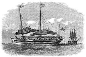
Attempt to Capture the Passenger-steamer "Fei Ma" ("Flying Horse") by 53 Imperial Junks... 1857Attempt to Capture the Passenger-steamer "Fei Ma" ("Flying Horse") by 53 Imperial Junks, in Canton River
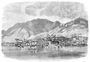
Hong-Kong: Central Portion of the Town of Victoria, 1857. Creator: UnknownHong-Kong: Central Portion of the Town of Victoria, 1857. General view showing...the central part of the town of Victoria, lying at the base of the lofty hills
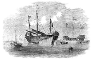
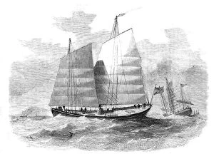
Chinese Merchants Lorchas, Canton River, 1857. Creators: Edwin Weedon, UnknownChinese Merchants Lorchas, Canton River, 1857. Second Opium War. The lorcha is used in the coasting trade of China by the English
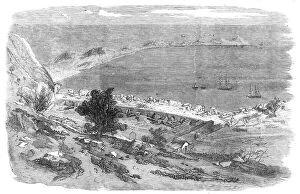
The War with China - Interior of the Anunghoy Bogue Forts, sketched after their demolition... 1857. Creator: UnknownThe War with China - Interior of the Anunghoy Bogue Forts, sketched after their demolition by the "Nankin" and the "Calcutta", 1857
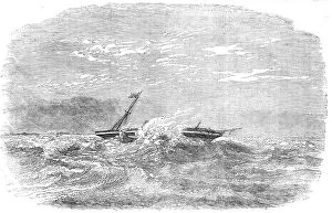
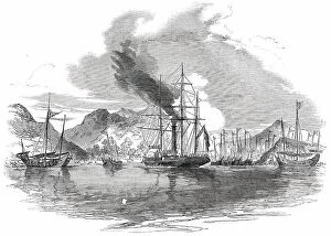
Wreck of "The Douro" steam-ship, on the Paracels, in the China Sea, 1854. Creator: UnknownWreck of "The Douro" steam-ship, on the Paracels, in the China Sea, 1854. Ship runs aground in bad weather between from Hong-Kong
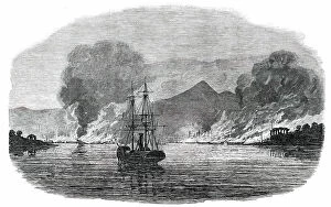
Destruction of Shap-'Ng-Tsai's Piratical Fleet, by the British, in the Gulf of Tonquin, 1850. Creator: UnknownDestruction of Shap-'Ng-Tsai's Piratical Fleet, by the British, in the Gulf of Tonquin, 1850. "It must be remembered that it is not the policy of any piratical force to become assailants
Capture and Destruction of Thirteen Piratical Chinese Junks... 1850. Creator: UnknownCapture and Destruction of Thirteen Piratical Chinese Junks, in Mir's Bay, by H.M. Steamer "Medea", 1850. "It must be remembered that it is not the policy of any piratical force to
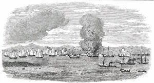
Destruction of a Piratical Chinese Fleet at Pinghoy, 1850. Creator: UnknownDestruction of a Piratical Chinese Fleet at Pinghoy, 1850....the burning of the pirate's fleet at Pinghoy, on the night of October 1
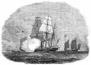
H.M.S. "Reynard" Capturing Two Piratical Junks off Hong Kong, 1850. Creator: Unknown. H.M.SH.M.S. "Reynard" Capturing Two Piratical Junks off Hong Kong, 1850. "It must be remembered that it is not the policy of any piratical force to become assailants against vessels of war;
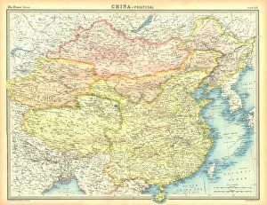
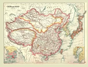
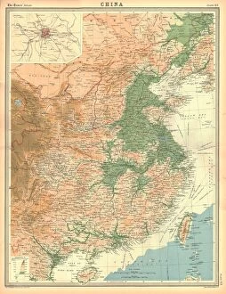
Political map of China. Map showing China, Mongolia, East Turkestan, Tibet and the Korean peninsula. Plate 62 from The Times Atlas
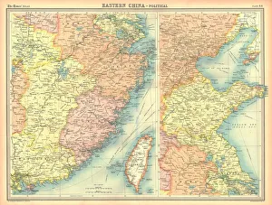
Political map of Eastern China, showing Taiwan, Tianjin and the Bohai Sea. Plate 64 from The Times Atlas
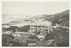
Swatow, c. 1868. Creator: John ThomsonSwatow, c. 1868. A work made of collotype, pl. vi from the album " illustrations of china and its people, volume ii" (1873)
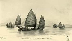
Chinese junks at the entrance to Hong Kong Harbour, 1898. Creator: Christian Wilhelm AllersChinese junks at the entrance to Hong Kong Harbour, 1898. Chinesische Dschunken vor dem Einfahrt in den Hafen von Hongkong
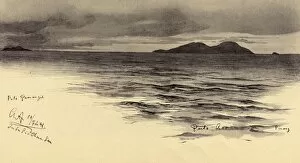
Pemanggil Island, Malaya, 1898. Creator: Christian Wilhelm AllersPemanggil Island, Malaya, 1898. Pulo Pemangil, Pulo Aor, Pinang, South China Sea. From " Rund um die Erde" [Round the Earth], written and illustrated by C. W. Allers
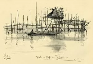
House on stilts and fishermen in Singapore Harbour, 1898. Creator: Christian Wilhelm AllersHouse on stilts and fishermen in Singapore Harbour, 1898. Fischer im Hafen von Singapore. From " Rund um die Erde" [Round the Earth], written and illustrated by C. W. Allers
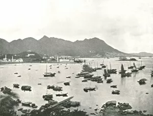
East Point showing Victoria Hills, Hong Kong, 1895. Creator: W &s LtdEast Point showing Victoria Hills, Hong Kong, 1895. Boats in the harbour of what was then a British colony, now part of mainland China
Map of China and Japan, 1902. Creator: UnknownMap of China and Japan, 1902. Showing Mongolia, Eastern Turkestan and Tibet, with insets of Hong Kong and Tokyo Bay. From The Century Atlas of the World. [John Walker & Co, Ltd. London, 1902]
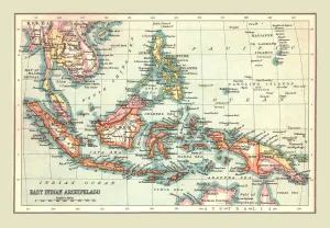
Map of the East Indian Archipelago, 1902. Creator: UnknownMap of the East Indian Archipelago, 1902. Showing Java, Sumatra, Borneo, Siam, The Philippines, Papua New Guinea and the South China Sea. From The Century Atlas of the World. [John Walker & Co, Ltd
Geographical map of China. Plate 63 from The Times Atlas
The destruction of the Chinese war junk in Ansons Bay, 7 January 1841 (c1857). Artist: George GreatbatchThe destruction of the Chinese war junk in Ansons Bay, 7 January 1841 (c1857). The East India Companys steamer Nemesis, and the boats of the Sulphur
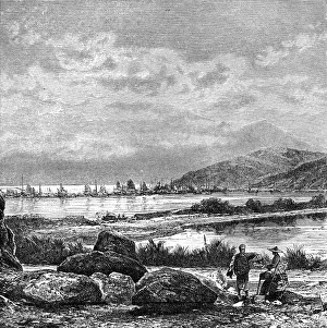
Hong Kong, view from Kowlun, c1890. Hong Kong seen from Kowloon, China. Illustration from The Universal Geography with Illustrations and Maps, Division XIII, (Virtue & Co Limited, London, c1890)