mail_outline sales@mediastorehouse.com
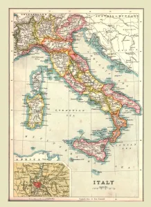
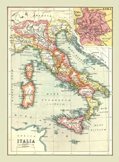
Map of Italy, 1902. Creator: UnknownMap of Italy, 1902. Showing the various administrative regions, the islands of Sardinia and Sicily, with inset of Rome. From The Century Atlas of the World. [John Walker & Co, Ltd. London, 1902]
Allegory of the Tyranny of the Duke of Alba in the Netherlands, c.1622-c.1630. Creator: AnonAllegory of the Tyranny of the Duke of Alba in the Netherlands, c.1622-c.1630
The Dairy Cow: The Dutch Provinces, Revolting against the Spanish King Philip II, Are Led by Prince Creator: AnonThe Dairy Cow: The Dutch Provinces, Revolting against the Spanish King Philip II, Are Led by Prince William of Orange, The States General Entreat Queen Elizabeth I for Aid, c.1633-c.1639
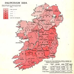
The Graphic Statistical Maps of Ireland; Pauperism 1884, 1886. Creator: UnknownThe Graphic Statistical Maps of Ireland; Pauperism 1884, 1886. From "The Graphic. An Illustrated Weekly Newspaper Volume 33. January to June, 1886"
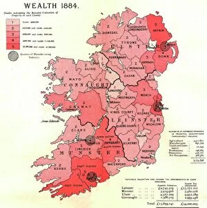
The Graphic Statistical Maps of Ireland; Wealth 1884, 1886. Creator: UnknownThe Graphic Statistical Maps of Ireland; Wealth 1884, 1886. From "The Graphic. An Illustrated Weekly Newspaper Volume 33. January to June, 1886"
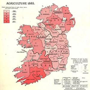
The Graphic Statistical Maps of Ireland; Agriculture 1885, 1886. Creator: UnknownThe Graphic Statistical Maps of Ireland; Agriculture 1885, 1886. From "The Graphic. An Illustrated Weekly Newspaper Volume 33. January to June, 1886"
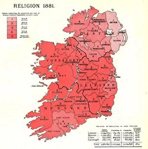
The Graphic Statistical Maps of Ireland; Religion 1881, 1886. Creator: UnknownThe Graphic Statistical Maps of Ireland; Religion 1881, 1886. From "The Graphic. An Illustrated Weekly Newspaper Volume 33. January to June, 1886"
The Graphic Statistical Maps of Ireland; Education 1881, 1886. Creator: UnknownThe Graphic Statistical Maps of Ireland; Education 1881, 1886. From "The Graphic. An Illustrated Weekly Newspaper Volume 33. January to June, 1886"
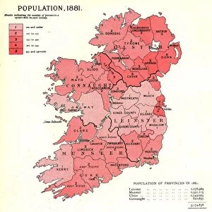
The Graphic Statistical Maps of Ireland; Population 1881, 1886. Creator: UnknownThe Graphic Statistical Maps of Ireland; Population 1881, 1886. From "The Graphic. An Illustrated Weekly Newspaper Volume 33. January to June, 1886"
Crossing the Forty-eight Rapids on Akiba Road in Totomi Province (Akiba kaido shijuhachi... 1852)Crossing the Forty-eight Rapids on Akiba Road in Totomi Province (Akiba kaido shijuhachi segoshi, Totomi), section of sheet no
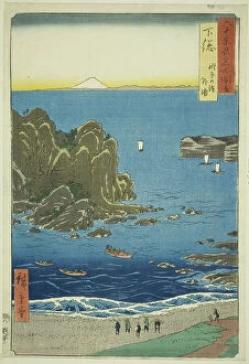
Inaba Province: Karo, Koyama (Inaba, Karo Koyama), from the series "Famous Places... 1853Inaba Province: Karo, Koyama (Inaba, Karo Koyama), from the series "Famous Places in the Sixty-odd Provinces (Rokujuyoshu meisho zue)", 1853
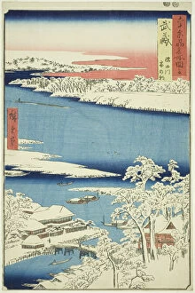
Musashi Province: Morning after Snow on the Sumida River (Musashi, Sumidagawa yuki no ashi... 1853)Musashi Province: Morning after Snow on the Sumida River (Musashi, Sumidagawa yuki no ashita), from the series "Famous Places in the Sixty-odd Provinces (Rokujuyoshu meisho zue)", 1853
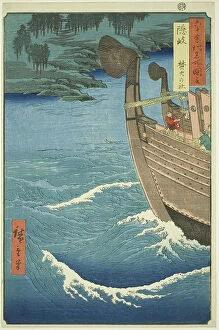
Oki Province: Takuhi Shrine (Oki, Takuhi no yashiro), from the series "Famous Places in... 1853Oki Province: Takuhi Shrine (Oki, Takuhi no yashiro), from the series "Famous Places in the Sixty-odd Provinces (Rokujuyoshu meisho zue)", 1853
Shimosa Province: The Outer Bay at Choshi Beach (Shimosa, Choshi no hama Toura), from the... 1853Shimosa Province: The Outer Bay at Choshi Beach (Shimosa, Choshi no hama Toura), from the series "Famous Places in the Sixty-odd Provinces (Rokujuyoshu meisho zue)", 1853
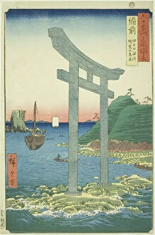
Bizen Province: The Torii of Yugasan near the Beach of Tanokuchi (Bizen, Tanokuchi... 1853. Creator: Ando Hiroshige)Bizen Province: The Torii of Yugasan near the Beach of Tanokuchi (Bizen, Tanokuchi kaihin Yugasan torii), from the series "Famous Places in the Sixty-odd Provinces (Rokujuyoshu meisho zue)
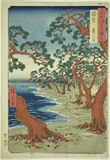
Harima Province: Maiko Beach (Harima, Maiko no hama), from the series "Famous Places... 1853Harima Province: Maiko Beach (Harima, Maiko no hama), from the series "Famous Places in the Sixty-odd Provinces (Rokujuyoshu meisho zue)", 1853
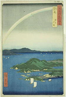
Tsushima Province: Clear Evening on the Coast (Tsushima, Kaigan yubare), from the series "... 1856Tsushima Province: Clear Evening on the Coast (Tsushima, Kaigan yubare), from the series "Famous Places in the Sixty-odd Provinces (Rokujuyoshu meisho zue)", 1856
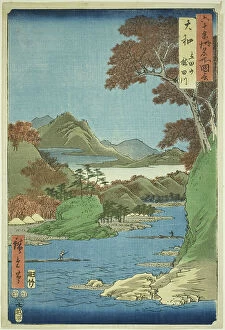
Yamato Province: Tatsuta Mountain and Tatsuta River (Yamato, Tatsutayama, Tatsutagawa), fr... 1853Yamato Province: Tatsuta Mountain and Tatsuta River (Yamato, Tatsutayama, Tatsutagawa), from the series "Famous Places in the Sixty-odd Provinces (Rokujuyoshu meisho zue)", 1853
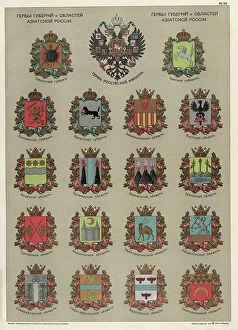
Seals of the Provinces and Oblasts of Asiatic Russia, 1914. Creator: Resettlement Department of the Land RegulationSeals of the Provinces and Oblasts of Asiatic Russia, 1914. From the atlas "Atlas of Asian Russia."
Map of Italia, (1902). Creator: UnknownMap of Italia, (1902). Showing the Italian peninsula during the Roman period, with place names in Latin, and inset of Rome. From The Century Atlas of the World. [John Walker & Co, Ltd. London, 1902]
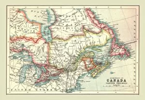
Map of the Dominion of Canada, Eastern Provinces, 1902. Creator: UnknownMap of the Dominion of Canada, Eastern Provinces, 1902. Showing Newfoundland, Nova Scotia, the Gulf of St Lawrence and the Great Lakes. From The Century Atlas of the World. [John Walker & Co, Ltd
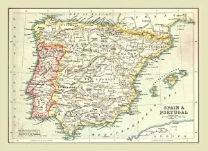
Map of Spain and Portugal, 1902. Creator: UnknownMap of Spain and Portugal, 1902. Showing the various provinces, and the Balearic Islands. From The Century Atlas of the World. [John Walker & Co, Ltd. London, 1902]
Map of the Dominion of Canada, 1902. Creator: UnknownMap of the Dominion of Canada, 1902. Showing the various provinces. From The Century Atlas of the World. [John Walker & Co, Ltd. London, 1902]
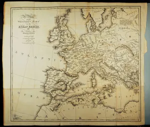
Map of the Roman provinces in times of Hadrian, printed in London in 1815