mail_outline sales@mediastorehouse.com
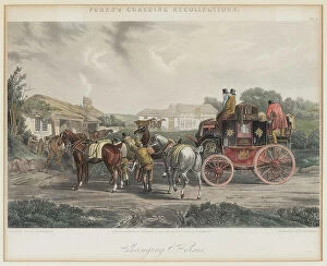
Changing Horses. Creator: Papprill, Henry A. (1816-1903)Changing Horses. Private Collection
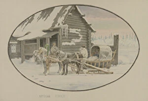
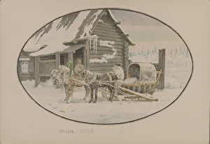
Postal station, 1862-1887. Creator: Mikhail ZnamenskyPostal station, 1862-1887. From an album of 32 original watercolors from the library of Tsar Nicholas II. The subjects include scenes from Tobol'sk, Berezov, Obdorsk (present-day Salekhard)
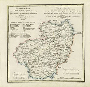
General Map of Kaluga Province: Showing Postal and Major Roads, Stations and... 1822General Map of Kaluga Province: Showing Postal and Major Roads, Stations and the Distance in Versts between Them, 1822. This 1822 map of Kaluga Province is from a larger work
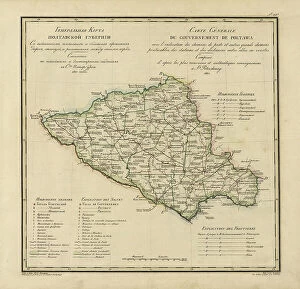
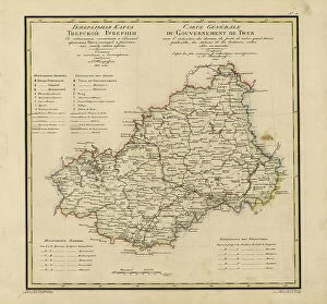
General Map of Poltava Province: Showing Postal and Major Roads, Stations and... 1821General Map of Poltava Province: Showing Postal and Major Roads, Stations and the Distance in Versts between Them, 1821. This 1821 map of Poltava Provinceis from a larger work
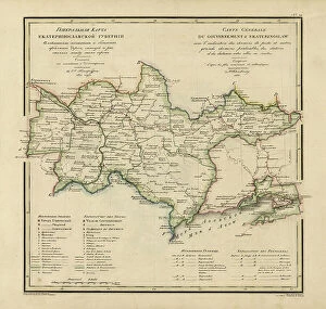
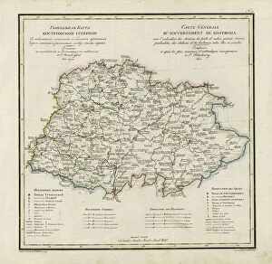
General Map of Ekaterinoslav Province: Showing Postal and Major Roads, Stations and the... 1821General Map of Ekaterinoslav Province: Showing Postal and Major Roads, Stations and the Distance in Versts between Them, 1821
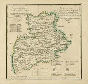
General Map of Chernigov Province: Showing Postal and Major Roads, Stations and... 1821General Map of Chernigov Province: Showing Postal and Major Roads, Stations and the Distance in Versts between Them, 1821
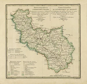
General Map of Kharkiv Province: Showing Postal and Major Roads, Stations and the... 1821General Map of Kharkiv Province: Showing Postal and Major Roads, Stations and the Distance in Versts between Them, 1821. This 1821 map of Kharkiv Provinceis from a larger work
General Map of Vladimir Province: Showing Postal and Major Roads, Stations and the... 1822General Map of Vladimir Province: Showing Postal and Major Roads, Stations and the Distance in Versts between Them, 1822. This 1822 map of Vladimir Provinceis from a larger work
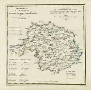
General Map of Kursk Province: Showing Postal and Major Roads, Stations and the... 1822General Map of Kursk Province: Showing Postal and Major Roads, Stations and the Distance in Versts between Them, 1822. This 1822 map of Kursk Provinceis from a larger work
General Map of Tver Province: Showing Postal and Major Roads, Stations and the... 1821General Map of Tver Province: Showing Postal and Major Roads, Stations and the Distance in Versts between Them, 1821. This 1821 map of Tver Provinceis from a larger work
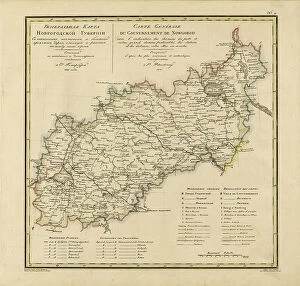
General Map of Novgorod Province: Showing Postal and Major Roads, Stations and the... 1821General Map of Novgorod Province: Showing Postal and Major Roads, Stations and the Distance in Versts between Them, 1821. This 1821 map of Novgorod Provinceis from a larger work
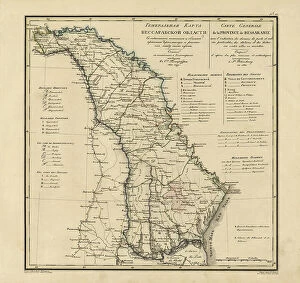
General Map of Bessarabia: Showing Postal and Major Roads, Stations and the... 1821General Map of Bessarabia: Showing Postal and Major Roads, Stations and the Distance in Versts between Them, 1821. This 1821 map of Bessarabia is from a larger work
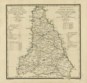
General Map of Minsk Province: Showing Postal and Major Roads, Stations and the... 1821General Map of Minsk Province: Showing Postal and Major Roads, Stations and the Distance in Versts between Them, 1821. This 1821 map of Minsk Province is from a larger work
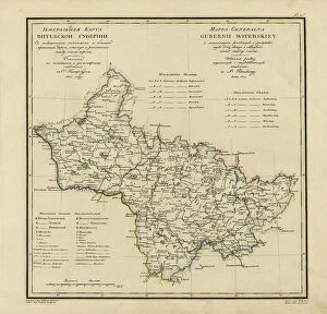
General Map of Vitebsk Province: Showing Postal and Major Roads, Stations and the... 1820General Map of Vitebsk Province: Showing Postal and Major Roads, Stations and the Distance in Versts between Them, 1820. This 1820 map of Vitebsk Provinceis from a larger work
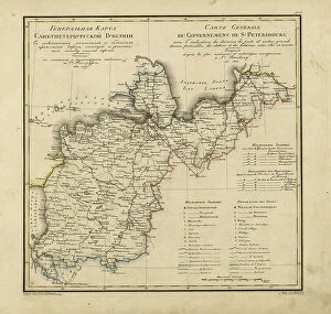
General Map of Saint Petersburg Province: Showing Postal and Major Roads, Stations and the... 1820General Map of Saint Petersburg Province: Showing Postal and Major Roads, Stations and the Distance in Versts between Them, 1820
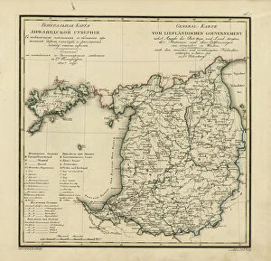
General Map of Livland Province: Showing Postal and Major Roads, Stations and the... 1820General Map of Livland Province: Showing Postal and Major Roads, Stations and the Distance in Versts between Them, 1820. This 1820 map of Livland Provinceis from a larger work
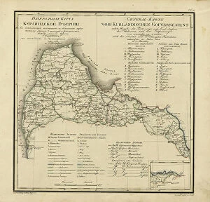
General Map of Courland Province: Showing Postal and Major Roads, Stations and the... 1820General Map of Courland Province: Showing Postal and Major Roads, Stations and the Distance in Versts between Them, 1820. This 1820 map of Courland Province is from a larger work
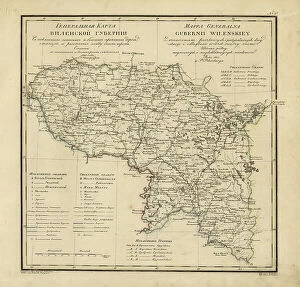
General Map of Vilnius Province: Showing Postal and Major Roads, Stations and the... 1820General Map of Vilnius Province: Showing Postal and Major Roads, Stations and the Distance in Versts between Them, 1820. This 1820 map of Vilnius Provinceis from a larger work
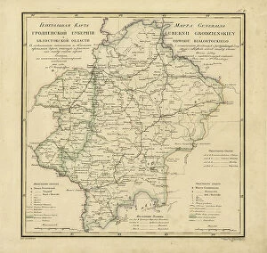
General Map of Grodno Province and the Belostok Region: Showing Postal and Major Roads... 1820General Map of Grodno Province and the Belostok Region: Showing Postal and Major Roads, Stations and the Distance in Versts between Them, 1820
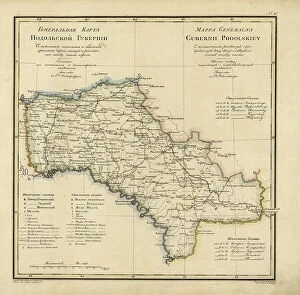
General Map of Podolsk Province: Showing Postal and Major Roads, Stations and the... 1820General Map of Podolsk Province: Showing Postal and Major Roads, Stations and the Distance in Versts between Them, 1820. This 1820 map of Podolsk Provinceis from a larger work
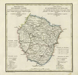
General Map of Yaroslavl Province: Showing Postal and Major Roads, Stations and the... 1822General Map of Yaroslavl Province: Showing Postal and Major Roads, Stations and the Distance in Versts between Them, 1822
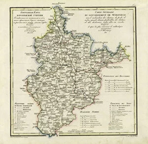
General Map of Voronezh Province: Showing Postal and Major Roads, Stations and the... 1822General Map of Voronezh Province: Showing Postal and Major Roads, Stations and the Distance in Versts between Them, 1822. This 1822 map of Voronezh Provinceis from a larger work
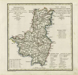
General Map of Tambov Province: Showing Postal and Major Roads, Stations and the... 1822General Map of Tambov Province: Showing Postal and Major Roads, Stations and the Distance in Versts between Them, 1822. This 1822 map of Tambov Provinceis from a larger work
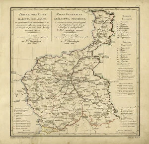
General Map of the Polish Empire: Showing Postal and Major Roads, Stations and the... 1820General Map of the Polish Empire: Showing Postal and Major Roads, Stations and the Distance in Miles Between Them, 1820. This 1820 map of the Polish Empire, then part of the Russian Empire
General Map of Kostroma Province: Showing Postal and Major Roads, Stations and... 1822General Map of Kostroma Province: Showing Postal and Major Roads, Stations and the Distance in Versts between Them, 1822. This 1822 map of Kostroma Provinceis from a larger work
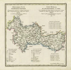
General Map of Orel Province: Showing Postal and Major Roads, Stations and... 1822General Map of Orel Province: Showing Postal and Major Roads, Stations and the Distance in Versts between Them, 1822. This 1822 map of Orel Province is from a larger work
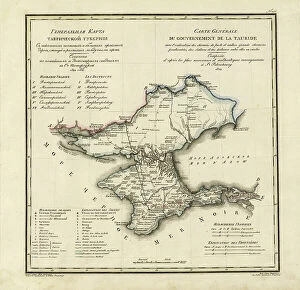
General Map of Taurida Province: Showing Postal and Major Roads, Stations and.. 1822General Map of Taurida Province: Showing Postal and Major Roads, Stations and the Distance in Versts between Them, 1822. This 1822 map ofTaurida Provinceis from a larger work
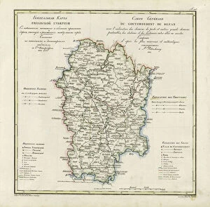
General Map of Ryazan Province: Showing Postal and Major Roads, Stations and... 1822General Map of Ryazan Province: Showing Postal and Major Roads, Stations and the Distance in Versts between Them, 1822. This 1822 map of Ryazan Provinceis from a larger work
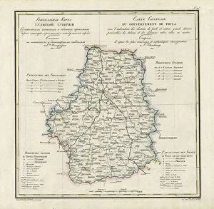
General Map of Tula Province: Showing Postal and Major Roads, Stations and... 1822General Map of Tula Province: Showing Postal and Major Roads, Stations and the Distance in Versts between Them, 1822. This 1822 map of Tula Provinceis from a larger work
Postal station, 1862. Creator: Znamensky, Mikhail Stepanovich (1833-1892)Postal station, 1862. Found in the Collection of the Russian State Library, Moscow